Survey of London: Volume 27, Spitalfields and Mile End New Town. Originally published by London County Council, London, 1957.
This free content was digitised by double rekeying. All rights reserved.
'The precinct of St. Mary Spital: The Old Artillery Ground', in Survey of London: Volume 27, Spitalfields and Mile End New Town, ed. F H W Sheppard (London, 1957), British History Online https://www.british-history.ac.uk/survey-london/vol27/pp24-38 [accessed 3 May 2025].
'The precinct of St. Mary Spital: The Old Artillery Ground', in Survey of London: Volume 27, Spitalfields and Mile End New Town. Edited by F H W Sheppard (London, 1957), British History Online, accessed May 3, 2025, https://www.british-history.ac.uk/survey-london/vol27/pp24-38.
"The precinct of St. Mary Spital: The Old Artillery Ground". Survey of London: Volume 27, Spitalfields and Mile End New Town. Ed. F H W Sheppard (London, 1957), British History Online. Web. 3 May 2025. https://www.british-history.ac.uk/survey-london/vol27/pp24-38.
In this section
CHAPTER III - The Precinct of St. Mary Spital: The Old Artillery Ground
The Old Artillery Ground had formed the southern part of the precinct of the Priory of St. Mary Spital. On 3 January 1537/8 it was leased, as the ’Tesell grounde’, by the prior to the ’Fraternyte or Guylde of Artyllary of longebowes, Crossebowes and handegonnes’ for 297 years at a yearly rent of 20s. (fn. 1) The Ground was described as adjoining the priory and lying within its precinct, the east, south and west sides enclosed by ’newe brycke walles’ and the northern part unenclosed. The east side measured 720 feet, the south side 171 feet and the south-west side 360 feet; the unenclosed northern part measured 360 feet in length and breadth. This corresponds approximately to the later dimensions of the Ground and Agas probably errs in placing the west wall considerably further east than its position in the later seventeenth century.
Stow explains the name of the Ground as deriving from the ’tasels’ (or teasels) planted there for the use of clothworkers, (fn. 2) who employed them to raise the nap on cloth. The continued validity of the lease granted less than a year before the priory's dissolution suggests that the ground had customarily been leased. (fn. 3) In view of the immience of the dissolution of the priory, the grant may have been made at the instance of the King (see William Thomas's suggestions in 1581–2, page 25).
On 25 August of the previous year the Fraternity had been incorporated by royal charter granted to ’Sir Cristofer Morres, Knight, Maister of our Ordenancs, Anthony Knevett and Peter Mewtes Gentlemen of our Preve Chambre Overseers of the Fraternitie or Guylde of Saint George’. It constituted them ’Overseers of the Science of Artillary that is to witt for Longe Bowes Crosbowes and Handgonnes etc.’ and the ’Rulers of the said Felliship of Artillary’. They were to ’founde … and establisshe a certeyne perpetuall Fraternitie of Saint George’ which was thereby incorporated as the ’Fraternitie or Guylde of Artillary of Longbowes, Crosbowes and Handegonnes’. The Fraternity was empowered to exercise at butts and ’at the Game of the Popinjaye and other Game or Games as at Fowle and Fowles’ in the City of London, its suburbs and elsewhere. (fn. 4) It is not clear whether the Society thus incorporated had existed previously or not. The charter does not designate the ’Tesell Ground’ as the headquarters of the Society but it is evident that it was to this corporation that the Ground was leased in 1537/8.
It has sometimes been supposed either that the lease of the Ground was made to the ’Gunners of the Tower’ for the exercise of ’great and small artillery’ and not to the Guild of St. George (from whom the Honourable Artillery Company claimed to derive (fn. n1) ) or that separate charters were granted in 1537 to the Guild of St. George and to the ’Fraternity of Artillery or Gunners of the Tower’. (fn. 5) Whether the corporation to which the charter and lease were granted was an independent society or an organization of royal servants, and whether its rights were inherited by the (Honourable) Artillery Company or the Tower Ordnance or by neither is uncertain. In the early seventeenth century the use and tenure of the Ground was constantly disputed, but neither the Company nor the Ordnance officers possessed the original lease or charter, or could establish a title to the Ground back to Henry VIII's reign. But apparently only one society was concerned in the transactions of 1537–8, a society at that time commanded by a Master of the Ordnance, at that time exercising only small arms, and owing its tenure of the Ground to its lease from the prior.
On the dissolution of the priory the ’Tesell Ground’ passed into the possession of the Crown and, unlike the rest of the precinct, remained the property of the Crown, except for the years 1550–3, until 1682.
In 1540–1 the Ministers' Accounts for the former priory mention ’le Tessell grounde’ as being held by the ’M[against]ro gubernatoribus de lez guners’ under the lease of 1537/8. (fn. 6)
In 1550 Edward VI granted ’le Tesell Grownde’ with other property to John, Earl of Warwick (later Duke of Northumberland). It returned to the Crown's possession in 1553 on Northumberland's attainder. (fn. n2) The grant of 1550 describes the Ground as in the tenure of the Company or Guild of the art of longbows, crossbows and hand-guns. (fn. 8)
Agas's map of c. 1560–70 shows gunnery practice in the Ground, which appears to be completely surrounded by walls.
In 1581 suggestions were made to the Privy Council, probably by William Thomas, the Master Gunner of England, for the better training of gunners for the service of the Crown. The writer stated that the guneners assembled once a year in the Artillery Garden (as the Ground was often called) to demonstrate their skill in great and small ordnance before the Master Gunner. He suggested that they should do so at least four times a year, in consideration that ’the said place comonly called the Artillerie garden was of purpose given by the prince of famouse memorie Kinge Henry the eight to th' office of th' ordinance for the trayning use and practize of Gonners’. (fn. 9) Probably the following year the Master Gunner claimed that a charter since lost was granted by Henry VIII to ’the fraternitie of Artillary in greate and small Ordenance’, and that ’th’ artillary gardein' was ’by his graces meanes appoineted, for the exercize of the same fraternitie’. He suggested that the missing charter should be replaced or confirmed by another to be made to a ’Fraternitye Companye and Fellowship of Artillerye of greate and smale ordenaunce’, with specific provision for the use of the Ground. (fn. 10) No new charter was, however, granted.
The writer seems to have erred in implying that a right to the Artillery Ground in particular had been conferred by Henry VIII on the Fraternity of Artillery and that the Fraternity was one exercising, as did the Ordnance Office, both small and great artillery. It appears from the writer's words that the gunners of the Ordnance Office did not then use the Ground frequently. By 1598 they used it weekly (see below).
In 1591 the Privy Council wrote to the Lord Mayor and Corporation requiring ’that whereas the artillery yarde belonginge to the cittie beinge erected for the trayninge of yonge gentlemen in London first broughte in by Mr. capten Allen Lewis, servante to the Lord Chamberlen, hathe bin of late discontynued, that [sic] the same maie forthwith upon the receipte hereof be renewed’. (fn. 11) This request probably refers to the use of the Artillery Ground by the Trained Bands of the City since 1585. The reference to the Ground as belonging to the City, repeated in later Privy Council orders, is difficult to explain.
Seven years later, in 1598, Stow speaks of the Ground as a large close formerly planted with ’Tasels’ and ’since letten to the Crosse-bow-makers, wherein they used to shoote for games at the Popinejay, now the same being inclosed with a brick wall, serveth to be an Artillerie yard, whereunto the Gunners of the Tower doe weekely repaire, namely everie Thursday, and there levelling certaine Brasse peeces of great Artillerie against a But of earth, made for that purpose, they discharge them for their exercise’. (fn. 2) The mention of the cross-bow makers shooting at ’the Popinjay’ by right of a lease seems to be an inaccurate reference to the Fraternity receiving the charter and lease of 1537–8. Stow appears to distinguish that Society from the gunners of the Tower exercising great artillery, and to suggest that the earlier Society no longer occupied the Ground.
On 3 July 1612 the Privy Council made an order allowing a ’Companie of Cittizens’ to be trained in arms in the Artillery Garden or elsewhere, the Council recalling ’a pressident [precedent] of certaine worthie Cittizens of London heretofor exercisinge Armes’. The number of members was limited to 250, increased to 500 in 1614. (fn. 12) In May 1613 the election by the Aldermen of officers of the Society practising arms in the Artillery Garden was approved by the City, (fn. 13) but subsequently there were disputes over the right of the City to elect officers without the approval of the Privy Council. In 1615 the Council approved the use of the Artillery Garden by the Middlesex Trained Bands. (fn. 14)
In 1616 the grant of the Lieutenancy of the Ordnance made to Sir Richard Morrison included the custody of the Artillery Garden. (fn. 15)
In the meantime, on 30 September 1612 James I had granted ’the Tessill ground’ to William Hammond (or Hamon), the Master Gunner. (fn. 16) But on an appeal in 1616 from the Society exercising arms in the Artillery Ground, the Council ordered Hammond to allow them free use of the Ground. (fn. 17) In 1620 an order of the Privy Council mentioned that the lease obtained by Hammond in 1612 had been acknowledged by him to be void ’for manifest imperfeccions found out by … Sir Edwarde Coke’, and had been surrendered. It was ordered that ’the said Artillery Yard’ should in future be ’restored to the publicke use for which it had formerly been imployed’, and ’not be from henceforth alienated’. (fn. 18) In 1622 the Society again complained of encroachments by Hammond, who had enclosed ’certain cabbage gardens’ and excluded the Society from the use of a butt. The Council ordered the gardens to be laid open again and made available for a ’butt and marke’. (fn. 19)
The Society joined to their complaint a request for permission to build on the ground a new armoury, the old being ruinous. The Council permitted this, ’so as the same be made of bricke and stone and in suche manner as may bee least subject to surprize’. (fn. 19) The armoury is said to have been completed in November 1622. (fn. 20) In 1631 the Company (as the Society is now described) claimed that building the ’Armoury and Forte’ had cost them £1,000. (fn. 21) Some verses were composed on the new armoury by the Marshal of the Artillery Company, Henry Petowe, indicating the Company's double dependence on royal and civic support. After celebrating the gallantry of the Company and the beauty of the building, they acknowledge a grant received from the City towards its cost.
Our City London is a Royal Thing,
For it is call'd The Chamber of our King:
Whose worthy Senate we must not forget;
Their Grant and our Request together met:
They cherish us, and we do honour them:
Where Soliders find true Love, they'll love again.
The lease of the teasel ground by the prior in 1537/8 is then mentioned, as if it were regarded as the Company's title to the Ground. The royal and conciliar favour is acknowledged.
Now have the noble Council of the King
Confirm'd the same, and, under Charles his Wing,
We now do exercise, and of that little
Teasel of Ground, we enlarge St. Mary Spittle.
Trees we cut down, and Gardens added to it.
Thanks be the Lords, that gave us Leave to do it. (fn. 22)
It is unlikely that the external dimensions of the Artillery Ground were enlarged at this time. Trees are shown on the Ground in the sixteenth-century maps of Agas and of Braun and Hogenberg, and the ’Gardens’ may have been those rescued from William Hammond and now taken into the armoury site or exercise ground. The site of the armoury, which appears on a plan of 1680/1 as the ’Great Storehouse’ (Plate 54c), is now the northern corner of Sandys Row and Artillery Passage. Pictorial representations of the armoury, not very accurately sited, appear on Ryther's map of c. 1640, Faithorne and Newcourt's map published in 1658, and Hollar's plan of 1667, but they agree only in suggesting a building of some size and consequence. In 1658 the buildings erected by the Company were described as an armoury, court house and workhouse, all of brick. (fn. 23) In 1660 the armoury was described as a room sixty-three feet long and twenty-four feet wide, with some other rooms adjoining. (fn. 24)
In 1623 a report was made to the Privy Council by officers of the Tower on certain abuses in its administration. With reference to the order made in 1620 that the Ground should be restored to public use, the invalidity of the grant of 1612 ’unadvisedly and indirectly procured by the said Hammond’ was acknowledged; nevertheless, it was argued that ’during all this time, and long before, and since, the Lieutenants of the Ordnance, and the Master Gunners of England under them, had and still held and enjoyed the said Garden for His Majesty's service, and so for the public, as anciently, beyond the memory of man, had been always customary’. But ’the citizens of London’ in building ’a fair house’ for their armoury had pulled down some of His Majesty's buildings. The Ordnance officers now suggested that ’there might be an acknowledgement from the City made and entered in the office of the Ordnance, that they hold it only by favour’, and that they should erect other houses to replace those demolished. (fn. 25)
The following year, 1624, the Lieutenant of the Ordnance claimed that the Lieutenant and Master Gunner held the Ground partly by the lease of 1537/8 and partly by the King's grant of the custody of the Ground to the Lieutenants of the Ordnance when appointing them; the Master Gunner had always trained scholars in gunnery there. The citizens of London, exercising there by virtue of leave granted to them twelve or thirteen years previously, had made a gate into ’the Ordinance way’, where the scholars were taught by the Master Gunner (presumably the ’Artillery Parke’ shown on the plan of 1680/1, Plate 54c), and had attempted to eject the scholars. They had also lately petitioned Parliament to ’gain the inheritance of the said garden to themselves’, and so deprive the Ordnance officers of their ancient right, ’never controverted, but only by theise unthanckfull guestes, lately and unadvisedly admitted only out of favour’. (fn. 26)
It is not known what effect, if any, these representations had. The dispute was, however, still in progress in April 1631, when the Council recommended that times be fixed for the use of the Ground by the two parties, and that a servant of the Company should keep the door of the Ground on the days of their exercise. (fn. 27) The following month the Master Gunner asked for the Company to be excluded from the ’Ordnance way’. The Council, however, specifically allowed the Company the key to the door of the platform where the butt was, on Mondays and Tuesdays, their days of exercise. (fn. 28) The Master Gunner had pleaded a verbal command from the King not to allow the Company access to the ’Ordnance way’. But the following year, the Company having experienced internal dissensions, the King wrote to the President commending the Company, asking them not to dissolve, and inviting them to have direct access to him in case of difficulty. (fn. 29) At the same time he declared his intention of taking the election of the Captain of the Company into his own hands. (fn. 30) In 1634 the election of officers was divided between the King, the City Corporation and the Company itself. (fn. 31)
The disputes over the use of the Ground induced the Company to look for headquarters elsewhere. In 1635 the Court of Aldermen ordered a view of a site in Bunhill Fields, the Company having applied for a piece of ground for their exclusive use. (fn. 32) In 1638 and 1640 similar orders were made. On 24 March 1640/1 a lease of part of Bunhill Fields was approved by the Court of Common Council. (fn. 33)
After the acquisition of the site in Finsbury the Company appear to have transferred most of their activities there. In 1649 it is called the New Artillery Ground, and the site east of Bishopsgate the Old Artillery Ground. (fn. 34) The Company did not, however, wholly sever its connexion with the Old Ground until 1658. On 11 September 1657 the Company ordered a march from the Old Artillery Ground to the New Ground. (fn. 35) On 29 December it was agreed that Mr. Wollaston, the Master Gunner, should purchase the Company's armoury in the Old Artillery Ground for £300. The removal of the arms had already been ordered. (fn. 36) On 29 September the clerk of the Artillery Company signed a receipt for £300 received from Richard Wollaston ’for the Armoury with the Courthouse, and all other the structures and buildings belonginge to the said Company, scituate and beinge in the Old Artillery Garden …’ (fn. 37) The receipt refers only to the grant of the building, (fn. n3) but henceforward the Artillery Company appear to have relinquished the Ground and its use for gunnery purposes was confined to the Ordnance Office of the Tower.
The property at the southern end of the Ground did not pass immediately into the actual possession of the Ordnance Office. Its purchase by the Master Gunner was apparently on behalf of a congregation of Baptists. In October 1658 William Kiffin, the Baptist divine, and others petitioned the Council (evidently without success) on behalf of themselves and their congregation for a ninety-nine-year lease of the Ground, except the proof-house and the use of the gun range. (fn. 38) The report made on this petition by the Ordnance Office stated that the armoury and other buildings erected by the Artillery Company had already been sold by the Ordnance Office to the petitioners. (fn. 39) Apparently the actual purchasers of these buildings included Hanserd Knollys, with whom Kiffin had previously associated in the propagation of Baptist tenets. (fn. 40) In July 1660 Knollys petitioned the Crown for a ninety-nine-year lease of the Ground, claiming that the conveyance from the Company to the Master Gunner had been in trust for Knollys, who had provided the £300, and that Wollaston had subsequently assigned the premises to him: Kiffin is not mentioned. Knollys had repaired the premises ’and builded a dwelling house where ye Court house was … And by compesition with the said rich: Wollaston hath paled and fenced in a little screed or parcell of ground for a Garden at his owne cost.’ (fn. n4) Knollys used the buildings ’for his conveniency of teaching schoole and boarding scholars’. According to the Surveyor General's report Knollys also preached ’to a Congregation of persons of his owne opinion in the said Roome or Armory House’. (fn. 41)
In January 1660/1 Lord Treasurer Southampton ordered a thirty-one-year lease to be made to Knollys, agreeing with the Master of the Ordnance in doubting ’that there is any great use of the said Armory Roome for his Majesties Service, and [he] wisheth as I doe that the said Artillary ground were exchanged for some other peece of ground lying more near to the Tower’. (fn. 42) But the Master Gunner thought the armoury useful for storing ’the Carriages of his Cannon’, and Knollys was evicted from the armoury. (fn. 24)
In 1670/1 Knollys petitioned the King for a confirmation of his purchase in 1658. (fn. 43) A report dated June 1674, on a further petition from Knollys, stated that the Ground could not be leased to him, being of use to the Ordnance Office and being granted to the Lieutenant of the Tower in his patent, ’and soe in the manner annexed to the office of the ordinance’. (fn. 44) Knollys should be compensated for his loss. In 1679 a further petition from Knollys, ’a very poor and aged minister’, was referred to the Surveyor General, who recommended him to the King's benevolent charity. (fn. 45)
With the Restoration the Old Artillery Ground had thus become limited to the use of the Ordnance Office. Some rebuilding or re-arrangement of the buildings at the south end of the Ground may have taken place at that time, as there is a reference in 1668 to the ’new storehouse’ and to the train of artillery it contained. (fn. 46) On 20 April 1669 Pepys visited the Ground, ’where I never was before, but now, by Captain Deane's invitation did go to see his new gun tryed, this being the place where the Officers of the Ordnance do try all their great guns’. (fn. 47) The will of Captain Valentine Pyne, (fn. 48) Master Gunner of England, living in the Old Artillery Ground, made in 1670, shows that the Master Gunner's dwelling-house was then in fact occupied by him. (fn. n5) The position is shown on the plan of 1680/1 (and is further confirmed by a later deed) to have been on the north side of the future Fort Street where it turned towards the north-east. (fn. 50)
In 1673 Lord Grandison (fn. n6) : asked for a long lease of the Ground, to build on the same. The Ordnance officers claimed that the buildings were necessary for His Majesty's service and that the gun range ’called a Parke’ was used for exercising a hundred feed gunners (fn. n7) and by the Master Gunner for training scholars in gunnery. The proof-house, used for proving small guns, was then lately repaired. (fn. 52) Earlier, in 1661, Charles, Lord Gerard of Brandon (fn. n8) had petitioned for a lease of two acres in the Ground. (fn. 53) In 1681 the Ordnance officers commented that the Ground had formerly ’runn some hazard of being beggd of his Majestie’, but had hitherto been preserved by arguments as to its usefulness in the King's service. (fn. 54)
Nevertheless the neighbourhood was being built up and the inducement to sell the Ground for building was growing. On 5 March 1668/9 the inhabitants of Spitalfields had petitioned against a brick-kiln being built in their midst by one John Pike, which among other disadvantages would ’endanger the lives and fortunes of the said inhabitants if any sparke of fyre should happen on the powder which is frequently laid a drying in the sun in ye old artillery ground neare adjoyning to the said fields, there being usually kept great quantitys of Powder in the storehouses there’. Sir John Robinson, Lieutenant of the Tower, reported that Pike's digging for brick-earth endangered the foundations of the Artillery Ground wall, and that ’there is a rowe of new buildings erected and erecting upon new foundations so neare his Majesty's stoares, that if fyre should happen, it will endanger the said Stoares, besides making the said artillery ground unusefull as to ye practise of shooting there’. (fn. 55) This refers to the building of Crispin Street.
Early in 1681 the sale of the Ground for building land was in contemplation. In March 1680/1 a plan of the Ground is said to have been prepared (fn. 52) and is probably that now in the Public Record Office (fn. 56) (Plate 54c). On 2 April 1681 the Ordnance officers reported that the usefulness of the Ground to the Crown was for the exercise of the ’fee'd gunner's and the proof of small guns; the Lieutenant General of the Ordnance held the Ground ’and consequently the benefit of the herbage and the rent of the other houses thereon standing’. But the Ground might be disposed of if other convenient places could be found in its stead. (fn. 54)
On 11 May 1681 William Harbord, the Surveyor General of Crown Lands, reported on the value of the Old Artillery Ground, built and unbuilt, and on what improvements might be made. The building in the south-west corner and the garden north of it were valued at £30 per annum. Adjoining this eastward was a great brick storehouse used for ’laying up Match & return'd bedding, Tents & other utensills’, valued, with a garden, at £20 per annum. Two other tenements with gardens eastward of the storehouse were valued at £30 per annum. At the north end of the Ground was the Master Gunner's dwelling-house with stables, coach-house, porter's lodge, two powder houses, a long house used for ’proving of small Gunns, and keeping of Stores’, and a charging house; all these were valued at £70 per annum. The remainder of the unbuilt ground contained nearly five acres, all walled with a high brick wall and valued at £10 per annum. The whole ground was thus valued at £160 per annum. (fn. 52)
Most of these features can be discerned on the map in the Public Record Office (Plate 54c), on which the total area of the Old Artillery Ground is given as 5 acres, 0 roods, 22 perches. This plan also shows the ’Artillery Parke’ along the east wall, apparently lined with trees or bushes on its west side, with a platform for guns at the southern end and a ’high earthen butt’ and wooden butts at the north end; the earthern butt is mentioned in a building lease of ground in Gun Street in 1682, and described as ’a piece of ground there now or heretofore called the Mount’. (fn. 57) The powder houses are shown halfway along the west side of the ’Artillery Parke’ (perhaps so placed to be as far as possible from danger of fire from other buildings), and adjoining an apparently artificial pond, also probably a precaution against fire. ’Raystd ground’ is shown south of the Master Gunner's house and the proving house. The plan was carefully made, but erroneously shows Goodman's Fields to the east instead of Spitalfields (perhaps by confusion with the Minories, another liberty used by the Ordnance). The denomination of the lane on the south-west of the Ground (later Sandys Row) as ’Gravell Lane’ is also probably an error.
On 6 December 1681 Sir Christopher Wren was asked to certify the Ground's value improved by building, and to attempt to find a purchaser. (fn. 58) A week later the Treasury asked the Ordnance Commissioners whether the Master Gunner could be found a house elsewhere. (fn. 54) On 23 December the Treasury inquired whether a market could be granted to a purchaser of the Ground, ’being the King's antient Inheritance and having been alwayes a Priviledged Place … if the same should prove to be within the liberties of the City’. (fn. 59) On the same day a letter was sent to Sir William Warren, Mr. Neale (probably Thomas Neale, the building speculator), Mr. Barebon (Dr. Nicholas Barbon), Sir Christopher Wren and Mr. Kille-grew, specifying that no proposal under £4,000 would be accepted for the Old Artillery Ground or under £5,200 if a market right were annexed to the grant. A regulation regarding the sale of the other Tower Liberty of Well close was made similarly. (fn. 59) The proximity to the City and the expansion of this part of London made it possible for the Crown to hope for considerable remuneration from the grant of a market, but in the end no such right was appended to the grant of the Ground, perhaps because the Ground's connexion with the parish of St. Botolph Bishopsgate was thought to bring it ’within the liberties of the City’, or because the City objected to it as an infringement of their market monopoly. The market right granted in 1682 was to the owner of the adjoining Spital Field in the hamlet of Spitalfields (fn. c1)
On 10 January 1681/2 the Treasury Lords required to have reserved for their use the money to be paid by Dr. Barbon for the purchase of Well Close and the Old Artillery Ground. (fn. 60) Barbon was characteristically slow in paying the purchase money and was sent two peremptory letters on 23 and 16 January from the Lords of the Treasury on the subject. (fn. 61) (fn. c2)
On 13 February 1681/2 the Old Artillery Ground was granted in perpetuity to George Bradbury and Edward Noell for £5,700, with licence to build new houses on the same. It was described as the Old Artillery Ground or Old Artillery Garden in or near the parish of St. Botolph's, Bishopsgate, and on the west side of fields or places commonly called Spitalfields, containing five acres and one rood, now encompassed with a brick wall; the buildings are described much as in l681. A rent of 6s. 8d. was reserved. (fn. 62) In subsequent deeds George Bradbury is described as of the Middle Temple, esquire, and Edward Noell as of the Inner Temple, gentleman. They were probably associated with Barbon in this grant, as the subsequent building leases were usually made by Bradbury and Noell together with Barbon and John Parsons. (fn. n9)
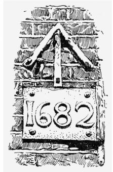
Boundary mark of Old Artillery Ground at No. 9 Brushfield Street
At the time of the grant the Crown set up metal broad-arrow marks at various points along the boundary; several of these marks can still be seen_at No. 43 Artillery Lane, No. 9 Artillery Passage, Nos. 9 and 14 Brushfield Street, as well as an incised mark, probably of later date, in George and Catherine Wheel Alley. The arrow at No. 9 Brushfield Street is marked 1682 (fig. 3); the arrow opposite at No. 14 may also be original, but both these must have been placed in their present positions when Union (now Brushfield) Street was cut through in the late eighteenth century. In 1943 a mark still existed at No. 42 Brushfield Street, (fn. 64) and in 1893 there was another dated 1682 at the corner of Artillery Lane and Sandys Row; (fn. 65) both these have now disappeared.
Building Development from 1682
The arrangement of the streets laid out when the Ground was built up was evidently determined by the relative lack of carriage-roads approaching the Ground (fig. 4). From Bishopsgate Street the only access street of any consequence was Artillery Lane (formerly Street) approaching the gateway near the south-west end of the Ground. On the east side streets led westward from the north and south ends of the Ground. A street was constructed continuing Artillery Lane in a southeasterly direction to the southern of these streets, Smock Alley (now the eastern end of Artillery Lane). The three main streets_the north-south part of Fort (formerly Duke) Street, Steward (formerly Stuart) Street, and Gun Street, which until the enlargement of Spitalfields Market stretched further north than it does now_were constructed running north and south and linked at the north end by the original Fort Street, a cross-street which led out or the Ground in a north-easterly direction to Lamb Street and the north side of Spitalfields. No access from the north-west corner of the Ground to Spital Yard was provided. Access by foot to the west side of the Ground from Bishopsgate Street seems to have been possible through George and Catherine Wheel Alley (called Rose Alley on Rocque's map). The limits of the ground available did not, however, allow the creation of east-west streets providing access from Bishopsgate Street to the market established in the same year as Bradbury and Noell's grant. Such direct access came only with the cutting of Union (now Brushfield) Street in the 1780's (see page 141). (fn. n10) A southward foot passage from Spital Square to Fort Street on the line of the northern arm of the Square, was
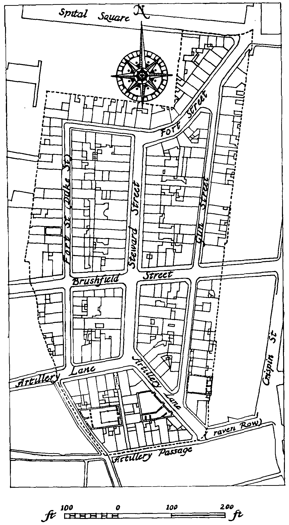
The Old Artillery Ground, lay-out plan. Based on the Ordnance Survey 1873–5 adumbrated in c. 1740, but not carried through (see page 69).
The names of Stuart and Duke Streets were evidently complimentary to the royal grantor and his brother: Gun Street runs approximately along the line of the gunnery range or ’Artillery Park’: Fort Street presumably refers either to the Ground's previous history as an enclosed place in military use (no fort seems to have stood near this site during the Civil War), or to the armoury.
The derivation of Parliament Court is not known. (fn. n11) It is called Parliament Alley in Rocque's map of 1746. It does not figure in the surviving deeds relating to the original building up of the Ground, but the French-congregation which had a chapel in Parliament Court existed there in about 1691 (see page 36), so the Court was presumably built with the other streets. It is mentioned in a deed of 1709 as ’the passage there left designed to lead to an intended Flesh-house’ this description may conceivably have been transferred from an earlier deed. (fn. 67)
The granting of building leases of the whole Ground, with the possible exception of Parliament Court, began soon after the transfer from the Crown. On 16 May 1682 a sixty-one-year lease was granted of ground on the west side of Fort (formerly Duke) Street by Bradbury, Noell, Bar bon and John Parsons of London, esquire, to Anglebreat Volezing; (fn. 68) on the same day a build ing lease for the same term of years was granted by Bradbury and Noell at the direction of Barbon and Parsons to John Nason of an angle plot on the east side of Gun Street at its south end, on which later stood two messuages and a meal shop. (fn. 57) On the third of the same month a plot on the south side of Artillery Lane in the Old Artillery Ground with a frontage of twenty-four feet had been leased, presumably in similar circumstances. (fn. 69)
There are records of building leases in June and July for sixty-one years from Bradbury, Noell, Bar bon and Parsons of two adjoining sites on the east side of Gun Street to Thomas Butler, citizen and plasterer, and to Thomas Burrowes, carpenter, of London, with frontages of some 16 feet and run ning back 40 feet to the Artillery wall; and also of two adjoining sites 108 feet in depth and possessing total frontages of 54 feet on the west side of Gun Street and the east side of Steward Street, to John Folltrop. (fn. 57) In August the same parties granted two sixty-one-year leases of adjoining sites on the north side of Artillery Passage (formerly Smock Alley), probably near the present site of Parlia ment Court, to William Parker, bricklayer, and John Goodman of St. Bartholomew's, carpenter. (fn. 70) On 3 January 1682/3 a sixty-one-year building lease was granted by the same to Thomas Denning of London, carpenter, of land described as fronting Fort Street on the south and Steward Street on the east; (fn. 71) the position of this plot is not very clear. But it is evident that by this time all the streets in the Ground were being constructed. In May 1683 ground facing Steward Street and Fort Street was described as abutting south on ground the foundations of which were ’bringing up by Nicholas Barbon of London, Doctor in Physick’. (fn. 72)
Other interests additional to those of Bradbury, Noell, Barbon and Parsons soon appear in the granting of building leases. Already in June and July 1682 four plots of land on the east side of Gun Street were leased by William Savill (fn. n12) to various persons of unspecified trades for terms slightly less than sixty-one years. (fn. 57) On 27 January 1682/3 he granted a lease of another plot on the east side of Gun Street to Edward Yates, citizen, tyler and bricklayer, for fifty-nine and three quarter years. (fn. 73) On 20 December 1684 other ground on the east side of Gun Street was leased by assignees of Savill, of whom one was Thomas Savage, citizen and glazier, to Rice Edwards of the Old Artillery Ground, sawyer, at a rent of a peppercorn and then £10 per annum. (fn. 74) Savage had on 9 January 1683/4 received the assignment of a lease of a frontage on the west side of Fort Street. These leases were presumably subsidiary to a lease held by Savill. (fn. 75)
After the first year Bradbury, Noell, Barbon and Parsons appear to have associated with others in the granting of building leases, and quite soon to have made some outright conveyances of un built land. On 1 May and 1 October 1683 these four, together with Sir James Ward of London, knight, William Morris of London, gentleman, and Samual Rawston of London, gentleman, granted building leases of a site facing Steward Street and Gun Street to Tobias Hardmeat of St. Ives, Hunts., grocer, (fn. 72) and of a site on the west side of Fort Street to William Prideaux of Lon don, gentleman. (fn. 75)
In the following year leases were granted by Barbon and Parsons in conjunction (perhaps by reason of a mortgage) with the Hon. Robert Sheffield (fn. n13) of Kensington, son of Dame Jane Sheffield, also of Kensington, who subsequently appears to have acquired the fee simple of part of the Ground, later owned by his descendants. On 19 July 1684 Robert Sheffield, by the direction and appointment of Barbon and Parsons, granted a building lease of a sixteen foot frontage on the west side of Gun Street to William Chapman of Whitechapel, carpenter. (fn. 79) On 6 June the same three had granted a building lease of ground with frontages of twenty feet on Gun Street and Steward Street to John Bloe, (fn. 57) elsewhere described as a carpenter. (fn. 80) On 10 February 1684/5 they granted two more leases of land between Gun Street and Steward Street. (fn. 57)
It appears that Robert Sheffield acquired the fee simple of part of the Ground at this time, for subsequent leases and conveyances of property in Gun Street and Steward Street were made by him alone. A Chancery suit brought by Sheffield throws light on the transference of interest and also on the interruptions to which the progress of such piecemeal estate developments were liable by reason of the limited resources of their executants. In a petition which he filed in Chan cery on 27 June 1692 Robert Sheffield stated that in 1684 he, together with Barbon and Parsons, had been and still was seized 'in his or their demesne as of fee’ of a piece of ground between Steward and Gun Streets with frontages of sixteen feet on each. On 19 July 1684 they had granted a building lease of this plot to William Sabine of St. Botolph's, Bishopsgate, joiner, for sixty-one years, Sabine covenanting to ’tyle and finish’ an intended brick messuage and make it fit for a tenant before 20 December next. Not doubting Sabine's performance of the covenant, Sheffield bought the ’interest and estate’ in the plot from Barbon and Parsons. Subsequently Sabine had conspired to claim some interest in the property and had neglected to complete the house. (fn. 80)
One of the defendants, William Bower, a scrivener, made answer on 17 August 1693. Sabine, wanting money to build and finish the house, had applied to Bower for a loan of £100. Through Bower he borrowed this sum from Anne Miller, a widow, to whom he leased the house on 18 September 1684 for sixty and a quarter years. Bower considered that the house, if completed, would have been a good security for the loan. Sabine, however, had neglected to com plete the house and Anne Miller, not wishing to do so herself, assigned the lease on 21 June 1686 to Edward Cooke of London, gentleman, for £50, which was the best price she could obtain. But she subsequently became dissatisfied at this loss of half her capital and Cooke also became unwilling for an unspecified reason to accept the assignment or to seal the counterpart, ’by which disagreement and otherwise the matter hath hung in suspence ever since’. The premises not being completed ’became more ruinous’, so that ’neither Anne Miller or her assignes do think it worth their while to meddle therewith’. Bower, disclaiming any active part in the affair, described Sabine as ’a very negligent person’. How the suit ended is not known. (fn. 81)
There are records of later leases granted by Sheffield alone, in 1687 and 1688, of sites on the east side of Steward Street and west side of Gun Street. (fn. 57) It is not known whether these were building leases, but on 10 May 1689 he granted a lease of a plot with a sixteen-foot frontage on the east side of Steward Street to Nicholas Lance of St. Martin in the Fields, plasterer, abutting south on a building (presumably that uncompleted) of William Sabine, in consideration of his costs and charges in building a new brick messuage there. (fn. 82)
In December 1709 Robert Sheffield was party to outright conveyances made to Peter Harley of the Old Artillery Ground, weaver, Adam Felsted of the same, weaver, and John Knowles, citizen and carpenter, and unspecified grants to Elizabeth Gibbon of London, widow. These included some 536 feet on the east side of Gun Street and the south-east side of Fort Street. (fn. 83)
On 21 February 1711/12 Sheffield made an outright grant of a further eighteen-foot frontage on the east side of Gun Street to Henry Allen, citizen and merchant tailor. (fn. 84) On 21 September 1714 he granted a bargain and sale for a year to Alexander Weller of Romford, Essex, gentleman. (fn. n14) This included frontages on the east side of Steward Street, both sides of Gun Street, the south-east side of Fort Street and the north-east side of Artillery Lane. (fn. 57) The conveyances of 1709, 1711 and 1714 together show that Sheffield was at this time seized of the entire east side of Gun Street as well as properties on the west side and in Steward Street.
It is not known whether the bargain and sale for a year to Alexander Weller was followed by a release to complete the conveyance. In 1744 Sir John Robinson, widower of Robert Sheffield's granddaughter and heiress, was in possession of seven adjoining messuages on the east side of Gun Street, which he leased for 4,998 years to Samuel Ireland, bricklayer, and William Curryer, car penter, both of Spitalfields. (fn. 85)
As will have appeared, a considerable number of builders were concerned with the development of this small area. The names of seventeen builders receiving building leases of ground within the Old Artillery Ground in the early years of development are known. (fn. n15) The houses usually had narrow fronts and the general quality of the build ing was probably not high. The Search Books of the Tylers' and Bricklayers' Company record that in June 1682 the Company ’Broke of Mr. Har wood's brickes in the Old Artillery Ground 250 fined at 6s. (fn. 86) The land of Ralph Harwood of Hackney was on the north side of Artillery Lane east of Duke (Fort) Street. Nothing of substance of the original buildings survives, although Nos. 3 and 9a Artillery Passage (Plate 54a), outside the Ground, probably represent the style of building within the Ground. Typical houses surviving in 1914 are shown in Plate 54b.
The greater part of the wall of the Old Artil lery Ground was preserved during the period of building development, although the leases included the parts of the wall upon which the various plots abutted. Some of the leases are known to have permitted buildings to be erected on or against the wall, but one building lease of 1684 of property on the east side of Gun Street specified that no breach should be made in the wall itself. (fn. 88) In 1725, however, a passage led from Gun Street into a wood-yard at the back of Crispin Street, necessarily passing through the wall. (fn. 89) The north-west corner of the wall existed in 1709 (fn. 50) and in 1755 premises in Crispin Street were described as abutting west on the Old Artillery wall. (fn. 90) In 1772 a considerable part of the wall was evidently still standing, as on 3 December the trustees of the liberty decided not to bear the cost of repairing damage to the part of the wall ’destroyed by Mr. Pitts’, as ’it would [form] a precedent for us to repair any other parts of our Town Wall if applied to by any of the Inhabi tants’. (fn. 91) It is not known how much longer the wall survived.
Later History of the Liberty
The grant of the Ground to private individuals did not mean the end of its existence as a ’privileged place’ and one of the Liberties of the Tower. On 10 June 1687 James II issued letters patent on account of differences that had arisen between the officers of the Tower and the authorities of the City of London and County of Middlesex. In this the Liberties of the Tower, including the cir cumference of the Tower, the Minories, Well Close and the Old Artillery Ground, were de clared to be immune from any jurisdiction of City or County. In a schedule the boundaries of the liberties were set out, including those of the Old Artillery Ground, (fn. 92) which continued to be included amongst the areas within the custody of the Lieutenant-General of the Ordnance into the eighteenth century. (fn. 93)
In the Act of 1774 establishing Trustees to regulate the poor and Commissioners to pave, cleanse, light and watch the ’Old Artillery Ground, within the Liberty of His Majesty's Tower of London’, the Constable and other officers of the Tower were included among the Commissioners, (fn. 94) and two wardens of the Tower joined in beating the bounds. (fn. 95) In 1834 the Gorund was, like the other Liberties of the Twoer, among the ’small parcels of land which enjoyed exemption from county rate without pro viding their own services’. (fn. 96) In 1852 its immunity from jurisdiction of City and County was suffi ciently appreciated forParticulars of the Privileges belonging to the Inhabitants of the Old Artillery Ground in the Liberty of His Majesty's Tower of London, containing copies of the grant of 1682 and George II's confirmation of the patent of 1687, to be published by a Bishopsgate printer. It was perhaps circulated among the ’Vestry’ or others, and contained the injunction: ’It is the Request of the Board, that any Gentleman leaving the Liberty, will return this Book, as it cannot benefit any but the Inhabitants.’ (fn. 97) In 1855 the liberty became part of the District of the Whitechapel Board of Works. The Vestry of the liberty in 1897 considered agitating for inclusion in the City of London, (fn. 98) but in 1900 it was constituted a part of the Borough of Stepney.
The nature and authority of the self-governing institutions of the liberty in the early and mid eighteenth century are not clear. There is no Local Act earlier than that of 1774. A minute book survives from 1729, by which it appears that the overseers of the poor laid business before annual meetings of the inhabitants. (fn. 99) These were perhaps held in the ’Parish House’ in Fort Street, listed in the earliest surviving sewer rate book of 1766, which was probably identical with the Vestry Hall existing in that street in 1873. (fn. 100)
The authority for raising money to finance the public services of the liberty before the Act of 1774 is not known. In 1735 a ’Town Meeting' decided that the streets should be better lit, ’so far as four shillings per house for ye Winter season will afford’. (fn. 101) By 1741 twenty-nine street-lamps were lit in the winter. (fn. 102) The Act of 1774 (fn. 94) authorized commissioners to levy a rate for paving, cleansing, lighting and watching the streets.
In the management of its poor the liberty's self sufficiency was limited by its small size. In 1731 a ’general meeting’ authorized the overseers to hire a house in Gun Street to accommodate the poor. (fn. 103) This was unsatisfactory or insufficient and in the same year a committee arranged with the Spitalfields overseers for the poor of the liberty to be received into the workhouse of that parish ’our said Precing being too small to Erect a Work-house’. (fn. 104) This arrangement probably con tinued until 1771 when another general meeting of inhabitants decided to hire a workhouse ’by way of Trial’, and to raise a subscription towards the expense of repairs and furnishings. (fn. 105) This work house was in Rose Lane, Spitalfields. (fn. 106) The Act of 1774 was thus giving statutory basis to an existing institution when it authorized trustees to acquire a workhouse. The poor were said to have ’lately much increased’ in the liberty while ’the same being situate in the Midst of the Silk and Woollen Manufactures’, the profit of the labours of the poor in the workhouse would lessen ’the heavy Taxes’ paid for their relief. (fn. 94) Some of the poor were nevertheless boarded-out at Lewisham. (fn. 106)
In 1792 the workhouse was transferred to a house hired at No. 29 Fort Street, where it re mained until 1813. (fn. 107) In the year 1802–3 some £455 was spent on maintenance in the workhouse and some £104 on outdoor relief. (fn. 108) In 1813 a resolution ’to farm out the Poor’ resulted in their being sent to ’Mr. Tipple’ at Hoxton, where they wound silk, but still had each ’a Pint of Porter on Holy Thursday according to Ancient Custom; when the bounds are beat’. (fn. 109) In 1815 a ’minute inspection of the House at Hoxton’ resulted in the poor being moved to Stepney, where the liberty authorities ’were well satisfied with the treatment etc.’ (fn. 110)
In 1837 the Old Artillery Ground was joined to the Whitechapel Union by an order of the Poor Law Commissioners.
The Old Artillery Ground was doubtless throughout its history a more uniformly poor area than the adjoining Liberty of Norton Folgate. It had few large houses, and was thickly inhabited. In 1801 its 185 inhabited houses accommodated I,428 people. (fn. 111) By 1881 its population had risen and with its 176 inhabited houses accommo dating 2,516 people (fn. 112) it was one of the most crowded areas dealt with in this volume.
The expansion of Spitalfields Market and war damage have almost completely destroyed its residential character.
No. 15 Gun Street
Demolished
Mark Gertler, the Jewish artist, was born here in 1891.
No. 3 Steward Street
Demolished
In 1763 and 1783 No. 3 Steward Street was occupied by Mason Chamberlin, a portrait painter and an original member of the Royal Academy. (fn. 113)
Nos. 24 and 25 Steward Street
Demolished
These were paired houses of early eighteenth century date, refronted around 1760 and other wise much altered. Each house was two rooms deep and contained a cellar-basement and four storeys. The tall plain fronts of yellow brick had three windows in each upper storey, all with gauged flat arches, stone sills, and recessed sashes with slender glazing bars. Between the fronts was a lead rainwater-pipe with a moulded box-head. The houses were uniformly finished inside, the rooms generally being lined with plain panelling, that in the best rooms being set in ovolo-moulded framing. Fluted Doric pilasters marked the junction of the narrow hall with the staircase com partment, and the staircase had cut strings, slender turned balusters, and a moulded handrail. Both houses were demolished towards the end of 1956.
Nos. 26 and 27 Steward Street
No. 26 demolished
These were paired houses of the late seventeenth century, both considerably altered. The front of No. 27 was rebuilt about 1870 and a coating of stucco hid the original brick front of No. 26, which was three storeys high with an added attic replacing the original roof garret. The ground storey had been altered, but each upper storey had three windows, that on the left a narrow one, with jambs and flat arches of red brick, which was also used for the band-courses between the storeys. The exposed flush frames of the original windows were furnished with modern sashes or casements. The back elevations were gabled and the original windows there had rough brick segmental arches. No. 26 was demolished towards the end of 1956.
No. 28 Steward Street
This house was built under a seventy-one-year building lease granted in May 1755 by T. B. Par son of Alldridge, Staffs., esquire, and Charles Lanoe of Twickenham, esquire, to Jacob and John Delamare, silk merchants. (fn. 114) The lessees undertook to build ’one good new substantial brick messuage’, with well-made bricks and mor tar, on the site of two existing houses which had been occupied by them and by Abraham Dela mare. The use of the house for the trade of brewer, dyer, hot presser, distiller, or tallow chand ler, was forbidden by covenant. The site abutted west on ground in Fort Street leased by Parson and Lanoe to Samuel Ireland, bricklayer, who was to share the cost of the erection of the party wall dividing the properties. (fn. 115)
In 1836 the house was occupied by Peter Bed ford, silk merchant and Quaker philanthropist, who was one of the early supporters of the soup kitchen in Brick Lane. (fn. 116)
Until 1880, when it was leased to a yeast mer chant, the house was occupied by silk merchants or manufacturers.
It is a large double-fronted house, with a cellar basement and four storeys, each with at least four rooms. The back elevation and interior features suggest an earlier date than 1755; the front, how ever, is typical of this date. It is built of fine grained bricks, yellow and pink in colour. The design is very austere, and has been made more so by the removal of a moulded cornice that must have underlined the attic storey, where there is now a plain cement band. The ground storey has a central doorway with two windows on either side, the extreme left one now converted into a doorway, and there are five windows evenly spaced in each upper storey. The plain rectangular openings have flat arches of gauged bricks, stone sills, and shallow reveals to the exposed frames. Except for the right-hand pair of ground-storey windows, all the sashes are modern. There is an excellent doorcase of wood, rather tall in propor tion, with a six-panelled door and fanlight framed by a straight-headed Classical architrave, flanked by plain narrow jambs and surmounted by a triangular ped ment resting on enriched vertical consoles. The back elevation is of yellow brick and the win dows have rough segmental arches and flush frames. The ground-floor room south of the staircase has a projecting semi-circular bow, con taining a three-light window with fluted mullions of wood under an unusually wide flat arch finely worked in gauged bricks.
The entrance-hall is lined with plain panelling set in ovolo-moulded framing. Six-panelled doors open to the rooms on each side, and Doric pilasters with triglyphed entablature-blocks mark the junc tion with the staircase compartment. The very spacious staircase is of early eighteenth-century character, and rises round a narrow oblong well. The moulded cut strings are embellished with boldly carved brackets, and the moulded handrail rests on turned balusters of stout section, one to each tread. Such panelling as remains in the dilapidated rooms is plain and generally set in ovolo-moulded framing on the ground and first floors, and in plain framing elsewhere.
Sandys Row Synagogue
Formerly Parliament Court Chapel
In about 1691 Jacques Laborie, a proselyte and possibly a former Roman Catholic priest, opened a French church in Parliament Court, near Artillery Lane, under the name of l'Eglise de l'Artillerie Lane, apparently with the permission of the Archbishop of Canterbury. (fn. 117) The church broke up three or four years later because of Laborie's conduct. The greater part of the con gregation moved to Crispin Street, and Laborie started a new church in Pearl Street. (fn. 117) Their building in Parliament Court was taken over in 1695 by a congregation which had been formed in about 1691 in or near Petticoat Lane. They now took the name of l'Eglise de l'Artillerie, and re mained in Parliament Court until 1786. (fn. 118) The freehold of the site was purchased in 1763 (fn. 119) and a new church was built. This building, which survives in a much altered form, was opened on 23 November 1766. One of the ministers of the church was Jacob Bourdillon, who took office on Christmas Day, 1731, and served for over fifty years. (fn. 120) In 1770 the congregation entered a union with La Patente, Brown's Lane (see page 191), and in 1786 both churches joined the Walloon church in Threadneedle Street. (fn. 118)
The building in Parliament Court was leased in 1792 to a Universalist Baptist church under Elhanan Winchester of Philadelphia. (fn. 121) When Winchester returned to the United States a few years later, the church was taken over by William Vidler, who had been associated with Winchester since 1794. When Vidler declared himself to be a Unitarian in 1801, a large part of his congregation seceded. (fn. 121) Vidler continued to lead a congrega tion in Parliament Court until his death in 1816. He was succeeded by William Johnson Fox, who in 1824 took the church to Finsbury where it eventually became an Ethical Society. (fn. 122)
In 1824 a congregation of Scottish Baptists under S. Stennett and J. Winning came from Cateaton Street. (fn. 123) In 1833 the building was called 'Salem Chapel', (fn. 124) and in 1836 listed as of unspecified denomination. (fn. 125)
In 1867 the French Church in Soho Square (originally the Threadneedle Street Church) leased the chapel in Artillery Lane to a congrega tion of Dutch Ashkenazi Jews who had been meeting since 1854 in a house in White's Row, and in Zetland Hall, Mansell Street. Changes were made to the interior, and a new entrance and vestry provided in Sandys Row, from the designs of N. S. Joseph. The building was consecrated as a synagogue on 6 November 1870. (fn. 126) In 1904 further alterations were made by Lewis Solomon, F.R.I.B.A. (fn. 127) The freehold was purchased by the congregation in 1923. (fn. 126)
The plan of the building is a simple rectangle, forty-eight feet in length east to west and thirty six feet wide, with a gallery extending round the north, south and west sides, reached by open stair cases in the north-west and south-west angles. The stock brick exterior is completely utilitarian and of no interest, but the interior is well designed in a style reminiscent of the Great Synagogue in Fournier Street, also built as a French Protestant church. Again, the plain plastered walls and the flat ceiling are joined by a quadrant cove springing from a cornice, here with brackets, and there are groined intersections over the arched heads of the windows, four on each side, two at the west end, and three at the east end. The gallery front, too, is underlined by a triglyphed frieze, supported by widely-spaced Doric plain-shafted columns. The Ark recess, which is modern, forms an eastern apse with a Baroque frontispiece of Corinthian plain-shafted pilasters supporting an entablature, surmounted by an elaborated pediment.
Artillery Lane Synagogue
Formerly Artillery Lane Chapel
Between Nos. 48 and 50 Artillery Lane is a much altered building, formerly a chapel; its exact date of erection and full history are uncer tain. Many congregations of Nonconformists have met in Artillery Lane, and it is often uncer tain which of them used this building; the evidence suggests that there may have been another place of worship in the same street.
Although a French Charity House, under the sign of the Pelican, was situated in Artillery Lane in 1695, (fn. 128) it seems probable that the Artillery Lane Chapel did not originate as a French church. In a deed of 1729 (fn. 129) two chapels are mentioned in or near the Artillery Ground, one a French chapel, the other a dissenting meeting-house. The former would be l'Eglise de l'Artillerie in Par liament Court, and the latter presumably stood on or near the site of the existing building. Rocque shows a chapel in this position on his map of 1746. If a second meeting-house existed in Artillery Lane at this time, as the evidence suggests, (fn. 130) it must have occupied a house or some other smaller premises which escaped Rocque's notice.
In 1707 a Baptist congregation under Nathaniel Hodges had come to Artillery Lane, perhaps from Loriner's Hall, Basinghall Street. They re mained until at least 1739, when their afternoon service was moved to Pinners' Hall, Broad Street, (fn. 131) but as a Baptist meeting in Artillery Lane is recorded until 1757, (fn. 132) it is possible that they may not have entirely severed their con nexion with Artillery Lane until some years later.
In the late 1740's an Independent congregation under the Rev. Mordecai Andrews came to Artillery Lane from Boar's Head Yard, Petticoat Lane. (fn. 133) It is probable that they occupied the chapel shown by Rocque. In about 1755 An drews's successor, Edward Hitchin, built a new chapel in White's Row (see page 147), which was in use by 1759. (fn. 134) The stylistic evidence suggests that the building in Artillery Lane, the facade of which survived until recently, was of mid eighteenth-century date. It is possible that Hitchin's congregation moved to White's Row partly because of the dilapidation of their chapel in Artillery Lane, and that this was rebuilt by a congregation of Independents under the Rev. John Richardson, who by 1760 were worshipping in Artillery Lane. (fn. 135) They remained there under his leadership until at least 1773. (fn. 136) (fn. c3) In 1810 there was a Calvinist (possibly Independent) meet ing in Artillery Lane, (fn. 137) and between 1811 and 1813 a short-lived Baptist church was situated in the same street. (fn. 138)
In 1833 another Baptist congregation settled in Artillery Lane. (fn. 139) In 1836 they were under the leadership of ’G. Moyll’. (fn. 140) More Baptists came between 1838 and 1841, and probably joined with them. (fn. 141) This congregation, said in 1848 to be under the ’Rev. George Moyl’, was situated on the east side of Artillery Lane, at No. 10 (now No. 41), which was previously occupied by the Lon don Dispensary and the Infirmary for Asthma. (fn. 142) ’G. Moyle’ left Artillery Lane in 1847, but the congregation appears to have continued to meet there for a number of years. (fn. 143)
In 1854 the freehold of the existing chapel was purchased by the Rev. James W. Massie, (fn. 144) possibly the ’J. Messer’ who opened a Baptist chapel called ’Ebenezer’ in Artillery Lane in 1856. (fn. 145) Massie sold the property in 1861. (fn. 144) If he used the building as a Baptist chapel, it is difficult to account for its being listed between 1856 and 1860 as an Independent chapel under the Rev. Julius J. Steinitz, (fn. 142) and on Stanford's map of c.1860 as a Congregational chapel.
Between 1861 and 1864 the existing chapel building was taken over by a Baptist congregation from Zetland Hall, Mansell Street. They left in 1895 to join Commercial Street Baptist Church. (fn. 146) In 1868 the Baptist church which had originally been led by Hanserd Knollys before 1660 in the Old Artillery Ground, returned to Artillery Lane, and remained there until 1876. (fn. 147) There is no evidence that this group met in the existing chapel with the Baptists who had come between 1861 and 1864.
In 1896 the Artillery Lane building was leased to a Jewish congregation, (fn. 144) and opened shortly afterwards as a synagogue. (fn. 142) It remained a synagogue until 1948, when the freehold was sold, (fn. 144) and the structure converted into a ware house.
The site of the building is irregular, roughly a truncated triangle, so that the front wall (north east) lies obliquely to the back wall (west) which is, more or less, at right angles to the side walls, the north being only half as long as the south (Plate 42d, fig. 5). Constructional evidence suggests that the two storeys of rooms on the south side were formed within the original meeting-room, reduc ing its width and probably eliminating one side of the gallery, of which the north-east and north sides survived until 1950. This gallery of four steppings was supported by widely spaced Doric columns of wood, and approached by staircases in the north east and south-east angles. The preacher's desk was placed against the windowless west wall. The ceiling is the only surviving feature of interest, its flat expanse broken in the centre by a large saucer dome rising to an octagonal lantern.
The front, of brick with a later face of stucco, was a single composition of seven bays, two storeys high, its architectural character suggesting a mid eighteenth-century date. From the left, the first, fourth and sixth bays contained doorways, each having a triangular-pedimented doorcase of wood.
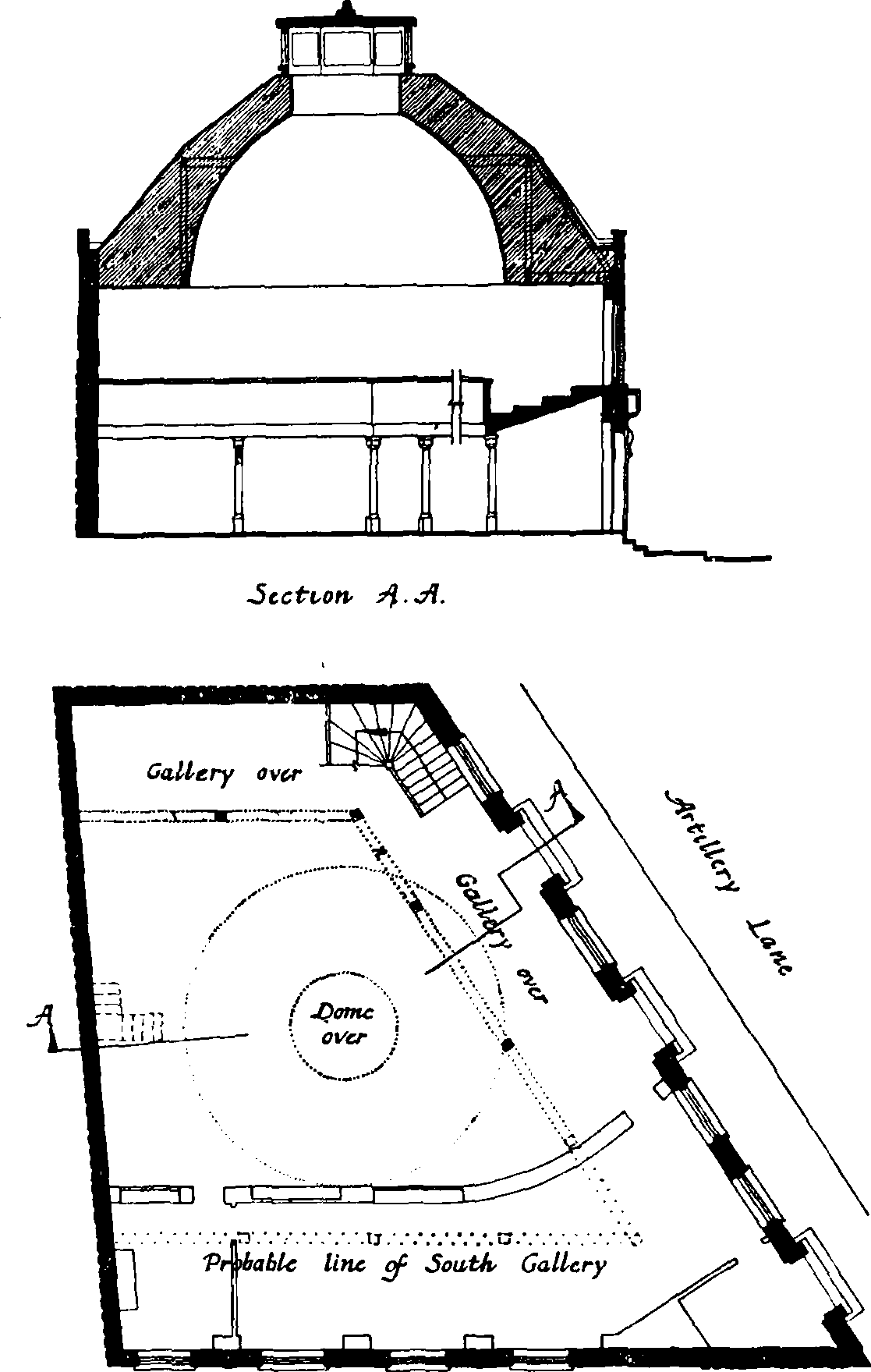
Artillery Lane Synagogue, formerly Chapel, plan and section
In each of the other bays was a segmental-headed window of squat proportion. Above was a range of seven arch-headed windows, those in the fourth and sixth bays being blind recesses. In 1950 this front was demolished and replaced by one of nondescript character.