A History of the County of Chester: Volume 5 Part 2, the City of Chester: Culture, Buildings, Institutions. Originally published by Victoria County History, London, 2005.
This free content was digitised by double rekeying. All rights reserved.
J S Barrow, J D Herson, A H Lawes, P J Riden, M V J Seaborne, 'Major buildings: City walls and gates', in A History of the County of Chester: Volume 5 Part 2, the City of Chester: Culture, Buildings, Institutions, ed. A T Thacker, C P Lewis (London, 2005), British History Online https://www.british-history.ac.uk/vch/ches/vol5/pt2/pp213-225 [accessed 30 April 2025].
J S Barrow, J D Herson, A H Lawes, P J Riden, M V J Seaborne, 'Major buildings: City walls and gates', in A History of the County of Chester: Volume 5 Part 2, the City of Chester: Culture, Buildings, Institutions. Edited by A T Thacker, C P Lewis (London, 2005), British History Online, accessed April 30, 2025, https://www.british-history.ac.uk/vch/ches/vol5/pt2/pp213-225.
J S Barrow, J D Herson, A H Lawes, P J Riden, M V J Seaborne. "Major buildings: City walls and gates". A History of the County of Chester: Volume 5 Part 2, the City of Chester: Culture, Buildings, Institutions. Ed. A T Thacker, C P Lewis (London, 2005), British History Online. Web. 30 April 2025. https://www.british-history.ac.uk/vch/ches/vol5/pt2/pp213-225.
In this section
CITY WALLS AND GATES
Roman Defences (fn. 1)
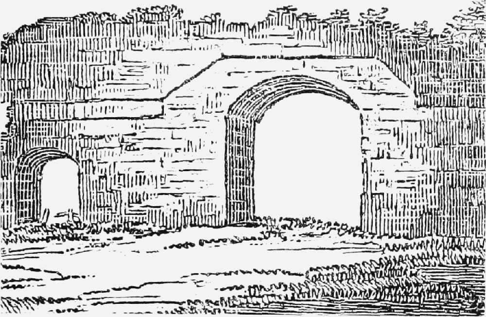
When first built in the 70s and 80s, the legionary fortress was defended by an earth rampart topped by a wooden palisade and provided with wooden gates and towers spaced at regular intervals. The double turfrevetted rampart appears to have been constructed in a modular fashion on a base c. 6 m. wide and to a height of c. 3 m. Its core was composed of earth dug from the defensive ditches alongside, the whole structure being set on a log corduroy base and held together by layers of branches and brushwood. The wooden towers, set at intervals of c. 50 m., were c. 4. 5 m. square and probably c. 7.5 m. high. The four main gates, undoubtedly also of timber, were probably similar to those at Inchtuthil on the river Tay.
The advent of the Twentieth Legion at the end of the 1st century saw the beginnings of a general reconstruction in stone. The work bears close similarities in design to the roughly contemporary walls at Gloucester and perhaps Inchtuthil, both also associated with the Twentieth. The rebuilding was abandoned, incomplete, in the early 2nd century and eventually finished over a hundred years later. Despite the hiatus, the walls were completed largely in accordance with the original intentions.
The stone curtain wall was not free-standing but rather a revetment of the earlier earthen rampart. A single face of masonry, it was built in a modular fashion: the wall walk, for example, was set c. 4.9 m. above the base, and was augmented by interval towers approximately twice that in height. The new wall, which was clearly designed to impress, was built of opus quadratum set on a chamfered plinth and base course and surmounted by a remarkable and as yet unparalleled decorative cornice. Above the cornice there was a course of rounded rebated blocks in which was set the breastwork, topped with capstones, some of which were ornamented.
The north gate seems to have been a relatively simple single arch, while the east, south, and west gates were more elaborate with twin portals. The east gate, forming the main entrance, was especially impressive; perhaps of three storeys, it was built of opus quadratum adorned with elaborate cornices. Parts of it survived, embedded in the fabric of its medieval successor, until the 18th century. (fn. 2)
The stone defences were probably not extensively remodelled in Roman times and seem never to have acquired the projecting bastions typical of fortress walls of the late 3rd and 4th century. Maintenance continued to the end of the 4th century.
Throughout the Middle Ages the north and east walls appear to have been maintained wherever they survived in reasonable condition. In 2000 a particularly fine stretch survived to the level of the cornice in the north wall east of the Northgate. Even where the medieval fabric was completely replaced in the 18th and 19th centuries, the Roman foundations survived and Roman masonry was on occasion reused. In general the medieval walls diverged from the line of the Roman ones only where the latter had collapsed outwards and could not be retained as the base of a new superstructure.
City walls and gates, plan
Like the east gate, the north gate may well have survived largely intact within its medieval successor, disappearing only in the early 19th century. The interval towers were apparently less well designed; although at least one, that at Abbey Green, was still largely intact in the early 10th century, none appears to have survived above ground after A.D. 1000.
Medieval and Later Walls
The extent to which the Roman defences were refused when Æthelflæd refortified Chester in 907 remains uncertain. One possibility is that she adopted the north and east walls, extending them to the river and creating thereby an L-shaped landward defence, (fn. 3) but there are also indications that the entire Roman enceinte was used. (fn. 4) Substantial sections of the north wall and portions of the east and west walls were repaired in early medieval times, in part with carved and inscribed Roman memorial stones. (fn. 5) Nevertheless, the likely length of the Anglo-Saxon defences, c. 1,700 yd., accords better with the L-shape than with the full legionary enceinte, and even if the Roman walls were refurbished it remains possible that the manned defences comprised only the northern and eastern sides of the fortress, extended to the river perhaps by earth walls. (fn. 6)
Whatever their form, the walls were probably complete by Edward the Elder's time (899-924), and were perhaps commemorated on a coin type apparently minted at Chester early in his reign, the reverse of which shows a tower. (fn. 7) They were kept in repair by the men of Cheshire at the rate of one man for every hide of the shire's assessment, an arrangement in force in 1066. (fn. 8)
The intrusion of the castle in the late 11th century probably involved the final abandonment of the south and west walls of the legionary fortress and the construction of an enlarged enceinte. Shipgate, in the southern riverside wall, seems to have been built by the 1120s, (fn. 9) and the line of the western defences may have been moved further west about then to form the full medieval circuit, still standing almost in its entirety in 2000. (fn. 10) The considerable building activity which took place in 1160–2 perhaps marked the completion of the defences. (fn. 11) By Earl Ranulph III's time (1181–1232) all four principal gates had been constructed, (fn. 12) and in the 1190s the parish church of St. Mary on the Hill and the nunnery, both located near the castle and outside the line of the Roman fortress, were said to stand inside the walls. (fn. 13)
As elsewhere, upkeep was largely financed by murages, occasional duties on merchandise entering and leaving the city, levied by the city authorities under royal grant. (fn. 14) The first recorded murage occurred in 1249 and was for five years, the money being collected by two officials called murengers. (fn. 15) Further murages were granted in 1290, 1297, and 1299, for three, five, and seven years respectively. (fn. 16) Royal permission was also needed to breach the defences: in 1246, for example, Henry III allowed the Franciscans to penetrate the walls to bring in building materials. (fn. 17)
In 1264 the defences were strengthened by the construction of the town ditch on the north and east, an action which involved the destruction of property outside the Northgate and the taking of land near the Eastgate. (fn. 18) It was perhaps then that the drum tower and the Saddlers' Tower were built, at points on the east wall where the Roman wall had collapsed or been robbed, and on a line slightly behind the Roman defences. (fn. 19)
The principal gates were in the charge of hereditary serjeants or keepers, who by the late 13th century had responsibility for organizing watches on the walls and collecting tolls. (fn. 20)
In 1321 a murage was granted for two years, and in 1322 the citizens contracted with John of Helpston, a royal mason, for a new riverside tower in the northwest of the city (Fig. 123, p. 216). (fn. 21) Further murages were granted in 1329, 1352, 1355, 1358, and 1363, with work continuing under royal master masons and in 1339 under the temporary supervision of a royal controller of murage. (fn. 22)
New Tower (left), spur wall, and Bonewaldesthorne Tower in later 18th century
In 1387 Richard II authorized the city to use the murage to rebuild the Dee Bridge, and perhaps because of that by 1395 the walls were claimed to be in great disrepair. (fn. 23) Succeeding murages in 1395 and 1397 were devoted to their restoration, and no further money was diverted to the bridge until 1407. (fn. 24) It was evident that the defences could still assume a military importance during the Ricardian rising in 1400, when the rebels seized the keys to the gates, and again in 1408–9, when attempts were made to enforce the watch on the walls. (fn. 25)
Although in the earlier 15th century royal officials continued to supervise repairs, (fn. 26) care of the fortifications became increasingly a local affair. In 1409 Prince Henry as earl of Chester allowed the mayor and commonalty to take murages for the repair of the walls, gates, and bridge, (fn. 27) and thereafter they were frequently imposed. (fn. 28) After 1466 the murengers, who by then had a regular income from customs levied on goods entering and leaving the city, served for two years rather than one, one retiring each year. (fn. 29) In 1506 murages became a permanent custom under the administration of two annually elected officials. (fn. 30)
Such developments did not, however, bring much improvement in the upkeep of the walls. In 1410, 1452, and c. 1531 men were indicted for breaking them down and carrying off stones. (fn. 31) By then the full circuit included some eight or nine watch towers, the four principal gates, and at least six posterns. The whole was embattled. Outside, to the north and east, lay the town ditch, and inside, except in the abbey precinct and between Eastgate and Newgate, a roadway to provide access. (fn. 32) In the later 16th or early 17th century the ditch was filled in. (fn. 33)
By the mid 16th century with the decline of Chester's trade the murengers' income had become inadequate. Some of the principal towers were rented and maintained as meeting places by the city's craft guilds, but the walls themselves were in poor condition. (fn. 34) In 1538–9 the city authorities agreed to pay a mason, Thomas Wosewall, 40s. a year and provide materials and two labourers to keep the entire circuit in repair. (fn. 35) Extensive renovations were undertaken in 1555–6, and in 1562 the contract was renewed, (fn. 36) but the results were not satisfactory: in 1569 a portion of the wall between the New Tower and the Watergate fell down, and in 1589 the entire defences were described as ruinous. In 1590 Wosewall surrendered his patent because he was unable to keep the walls in repair. (fn. 37) The murengers were increasingly reliant on special levies: in 1589 they were granted an assessment of £100 and in 1599 the profits from one year's toll on corn. (fn. 38) Even so, in 1600 the walls still endangered those walking on them, and a further assessment of £100 was ordered. (fn. 39) A 'great breach' between the New Tower and Watergate required £80 in 1608 and 100 marks in 1620. (fn. 40) Further assessments for repairs were levied in 1621, 1625, and 1629, but there appears to have been some resistance to their collection, and yields probably continued low, for the walls were still called ruinous in 1641. (fn. 41)
With the growing prospect of a civil war, measures were taken to improve the city's defences. (fn. 42) In September 1640 the corporation ordered repairs to the Eastgate, Newgate, and Bridgegate, and in 1641 it allocated all customs duties on wine imports (prisage) to the renovation of the walls. An additional assessment of 100 marks was granted in 1642. (fn. 43) In 1643, with the growing likelihood of a siege, new outer fortifications were built. They initially followed a line from the north wall near the Goblin Tower northwards to a point between Parkgate and Liverpool roads, and thence east to Flookersbrook Hall; from there they ran south and then east to Boughton, terminating at the river. The new works comprised trenches, mud walls, mounts, and pitfalls. Newgate and the New Tower were walled up, and the former ditch outside the Eastgate was perhaps re-excavated. In 1644 the line of the defences was brought back nearer the city to a turnpike at Cow Lane (later Frodsham Street), abandoning the enclosure of Flookersbrook; escarpments were deepened and widened, parapets raised, and new mounts thrown up around Cow Lane. (fn. 44) Finally, in February 1645 the fortifications assumed the form they had until the end of the siege: the outworks were brought back from the Cow Lane turnpike to Cow Lane Gate, and Morgan's Mount was constructed on the northern city wall near the Goblin Tower. (fn. 45)
The medieval defences suffered from the parliamentary bombardment during the siege. Two important breaches were made, a large one near the Newgate and a smaller one between the Goblin and New Towers, both in places where the fabric had already crumbled and been strengthened by earthen ramparts. (fn. 46) Modest disbursements were made in the later 1640s and 1650s to patch up the great breach near the Newgate and further breaches on either side of the Northgate. Major work costing over £120 was done near the Watergate between 1659 and 1661, and in the 1660s and early 1670s spending on repairs continued to be fairly heavy. (fn. 47) Yet the condition of the walls remained precarious. Although the antiquary Ralph Thoresby could describe them as in excellent condition in 1682, another opinion in 1686 was that they were 'far out of repair'. (fn. 48) In 1690 the corporation granted £160 for renovations, but there were still breaches in 1694. By 1700 the murage duties were in arrears. (fn. 49)
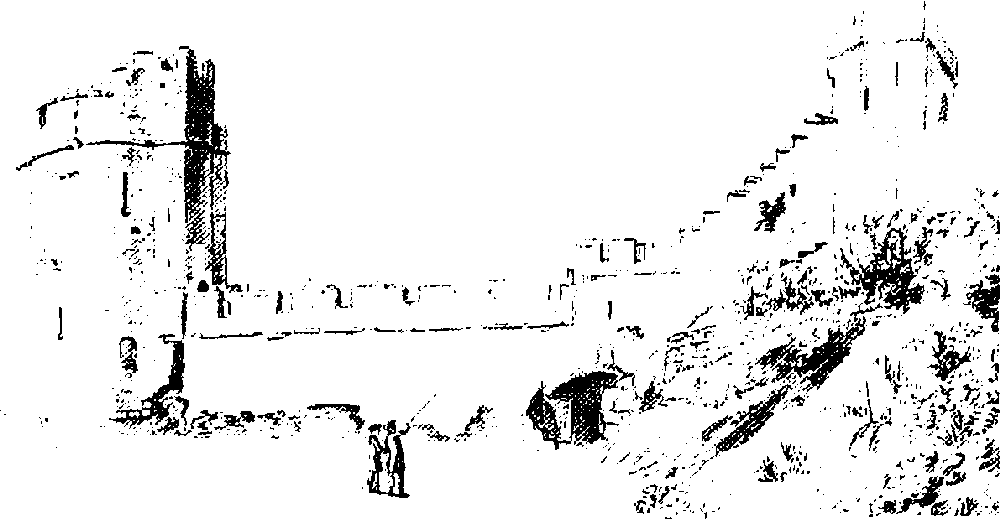
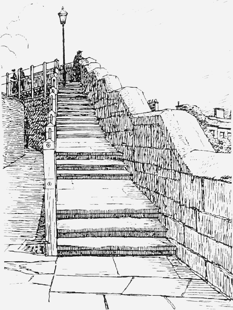
Nevertheless, the walls seem already to have become a popular promenade, perambulated for example by Thoresby in 1682, (fn. 50) and in 1707–8 the Assembly undertook major repairs with the object of restoring the entire circuit to use. The cost of £1,000 went towards repairing 'divers large breaches' and levelling and flagging the wall walk. (fn. 51) Thereafter the walls became one of the walks favoured by Henry Prescott, deputy registrar of Chester diocese, and his friends. (fn. 52) Access to the fashionable pleasure grounds in the Groves was made easier in 1720, when the corporation built Recorder's Steps, east of Bridgegate. (fn. 53) After all the improvements, the walls, though no longer of military use, were described in 1728 as 'of great delight and benefit' to the citizens. (fn. 54)
In the 18th century the walls were perambulated by such distinguished visitors as John Wesley and Samuel Johnson, though the walkway was not continuous as it was still interrupted by some of the towers over the main gates. (fn. 55) The reconstruction begun in 1707 continued piecemeal, and seems generally to have involved the total replacement of medieval fabric but the retention, where it existed, of Roman. (fn. 56) Work included the construction of the present unfortified parapet, the rebuilding between 1767 and 1810 of all the main medieval gates with wider arches, better for vehicles below and pedestrians above, (fn. 57) and attempts to render the wall walks more convenient by means of features such as the Wishing Steps, built in 1785 to ease the steep ascent east of Recorder's Steps (Fig. 124, p. 218). (fn. 58) Further work was done in 1828–9, when a collapsed portion between Abbey Street and the Phoenix Tower was rebuilt and Grosvenor Road was driven through the defences west of the castle; (fn. 59) shortly after, in 1830, part of the southern wall west of Bridgegate was moved further south to run along the new riverside embankment, a project involving the insertion of an archway to permit access to the extended enclosure of the castle. (fn. 60) In 1831 the walls were said to have been altered recently 'not so much for strength as for ornament'; the walks had been levelled, the battlements lowered, and the towers refurbished. (fn. 61)
The office of murenger was abolished in 1835, when its duties were vested in the corporation's finance committee. (fn. 62) The tolls at Eastgate, Northgate, and Watergate, most if not all of which were in the corporation's hands by 1662, were abolished in 1836. (fn. 63) Those at Bridgegate, acquired in the 17th century, had already been granted to the Dee Bridge Commissioners in 1824. (fn. 64)
Further work was done on the walls and towers in the late 19th century. In particular, at least 120 yd. of the north wall in Water Tower Street between the Northgate and Pemberton's Parlour were rebuilt or refaced in 1882–3, work which included a new gateway opposite Canning Street. (fn. 65) In 1887 and 1890–2 other stretches of the north wall west of the Phoenix Tower and west of the Northgate were reconstructed, and in both locations large numbers of inscribed and sculpted Roman memorial stones were found. (fn. 66) Attempts were made to strengthen the east wall north of the Kaleyards Gate in the 1930s, (fn. 67) and both that work and the earlier reconstruction in Water Tower Street were much renewed in the 1990s. (fn. 68) The city council remained responsible for maintenance work.
Wishing Steps, 1903
Alterations were made to the walls in 1846, when the Chester-Holyhead railway cut through the northwestern corner; in 1900–1, when Castle Drive was laid out beside the river and the wall walk was re-routed; and in 1966, when the north walkway was carried over the new inner ring-road on a concrete footbridge, named St. Martin's Gate. (fn. 69) Despite such breaches and remodellings, the walls still in 2000 formed an almost unbroken pathway and a delight to visitors.
Promenading the walls near King Charles's Tower, 1850s
Gates, Posterns, and Towers
The following description goes anti-clockwise from the Eastgate.
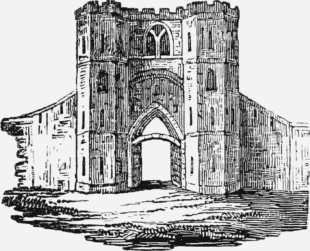
Eastgate
The earliest mention of the Eastgate is in the later 12th century. (fn. 70) It seems to have been enlarged in 1270, and a reference to it shortly afterwards as 'porta Cestriae' suggests that it was the principal gate of the city. (fn. 71) The keepers were responsible for the inspection of weights and measures, and were bound to find equipment for measuring salt. (fn. 72) The first known serjeant was Thomas of Ipgrave, whose widow Joan was granted the custody and tolls of the gate in 1275. Joan surrendered her rights in 1278 in return for a pension, and in 1286 the serjeanty was granted to Hervey of Bradford and his son Robert. (fn. 73) The Bradford family held it until 1376, when it was sold to William Trussell, from whose heirs it passed by marriage to the earls of Oxford. (fn. 74) About 1630 it was sold to Sir Randle Crewe. (fn. 75) In 1662 the Crewe family leased the tolls to the city, reserving for themselves the nomination of the serjeant. Thereafter the city appointed a keeper who remained responsible for inspecting the city's weights but who by 1666 had ceased to receive the profits of the gate or to pay the rent due to the Crewes. (fn. 76)
Old Eastgate, before 1768
In its final form, reached perhaps in the reign of Edward III, the medieval gate, which incorporated much of the Roman structure, was the 'strongest and most lofty in the city'. (fn. 77) The east elevation seems to have consisted of a fairly narrow Gothic archway flanked by two tall octagonal towers, with perhaps two smaller outer towers. (fn. 78) The inner western face was dominated by a large round arch which by the early 18th century was regarded as Roman. (fn. 79) It suffered early neglect, and by 1631 was ruinous, stones from it falling on adjacent houses. (fn. 80) Repaired in 1640, it was much battered in the siege, when perhaps it lost its two smaller towers. (fn. 81) Though it was repaired again in the 1670s, it seems quickly to have fallen into decay once more. (fn. 82)
In 1707 as part of the general renovations the ancient pedestrian passage on the wall walk over the Eastgate was reopened. (fn. 83) By the 1750s the gate itself was thought narrow and inconvenient, and in 1768 it was demolished and replaced at the expense of Richard, Lord Grosvenor, by a wider elliptical arch flanked by low pedestrian arches designed by an otherwise unidentified Mr. Hayden. (fn. 84) In 1898–9 ironwork and a clock, designed by John Douglas, were placed on the tower to commemorate Queen Victoria's Diamond Jubilee of 1897. (fn. 85)
Tower
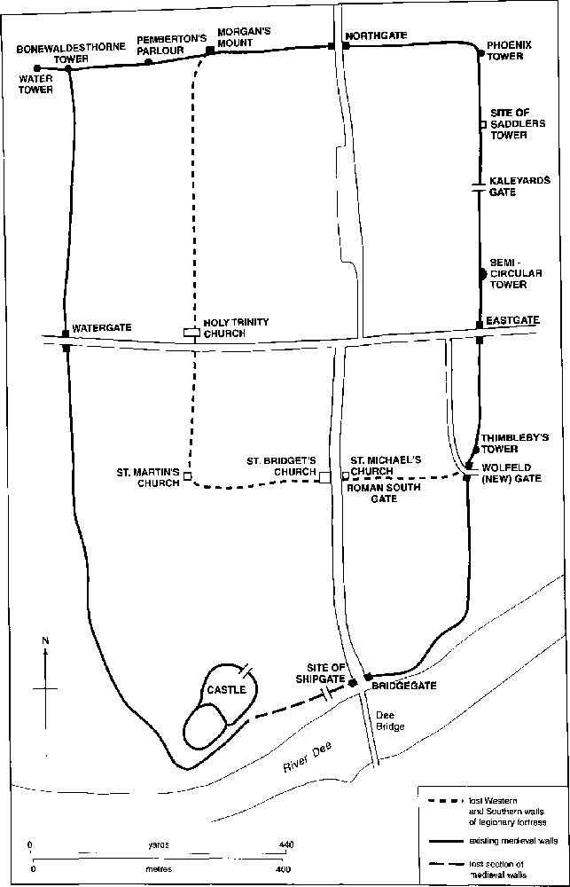
An unnamed tower lay north of the Eastgate c. 1588. (fn. 86) Its foundations, excavated in 1928 and surviving in 2000, show that it was semi-circular and bonded into a length of medieval wall set back slightly from the line of the Roman defences. It was probably built in the 13th century at a point where the Roman wall had collapsed. (fn. 87)

Eastgate, 1930s
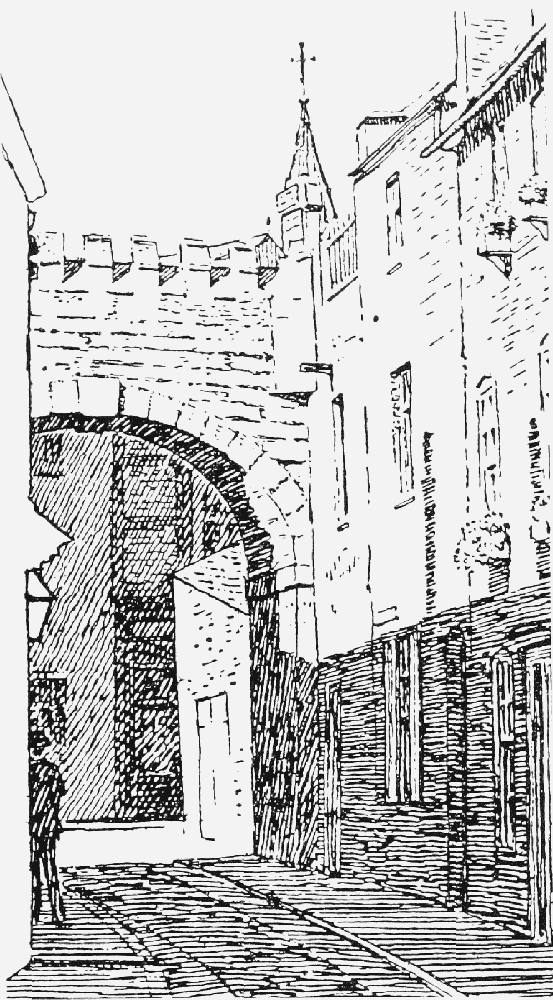
Kaleyards Gate and Walls
Chester abbey's kitchen garden, known as the Kaleyards, lay just outside the east wall of the city beyond the town ditch. The garden was surrounded by its own stone wall, (fn. 88) and from 1274–5 it was reached by a postern in the city wall. (fn. 89) The arrangement caused dissension between the abbey and the citizens, anxious about the security of the city. In 1322–3 it was agreed that St. Werburgh's should keep the postern closed in peacetime and make and maintain a drawbridge across the town ditch. The monks were also to replace the gate in their own wall with a smaller postern. (fn. 90)
The abbey was equally concerned to prevent trespass in its garden from the city walls, and in 1352 the abbot was indicted for obstructing the wall walk with a door. (fn. 91) In 1414, however, Henry V granted the abbey licence to close two small gates on the walls between Eastgate and Northgate, on condition that it allowed access to the murengers and those in charge of the defences in time of war. The licence was renewed in 1451 and 1538. (fn. 92)
Old Northgate, before 1808
The small gateway under the city wall existing in 2000 and leading into the former Kaleyards was probably built in the later 17th century. (fn. 93)
Saddlers' Tower
A square watch tower, shown on a map of 1745, stood c. 50 m. north of the Kaleyards Gate at a site marked in 2000 by buttress-like structures representing the stubs of its north and south walls. Aligned with the medieval defences, which stood 1.5 m. inside the Roman ones, the tower was built at a point where the Roman walls had collapsed or been robbed. (fn. 94) It was occupied by the Saddlers' company in the mid 16th century, (fn. 95) and was still their meeting house in the later 17th. (fn. 96) In 1690 it was repaired and said to be 241 years old. (fn. 97) The tower was taken down to the level of the walls in 1779–80 and demolished in 1828. (fn. 98)
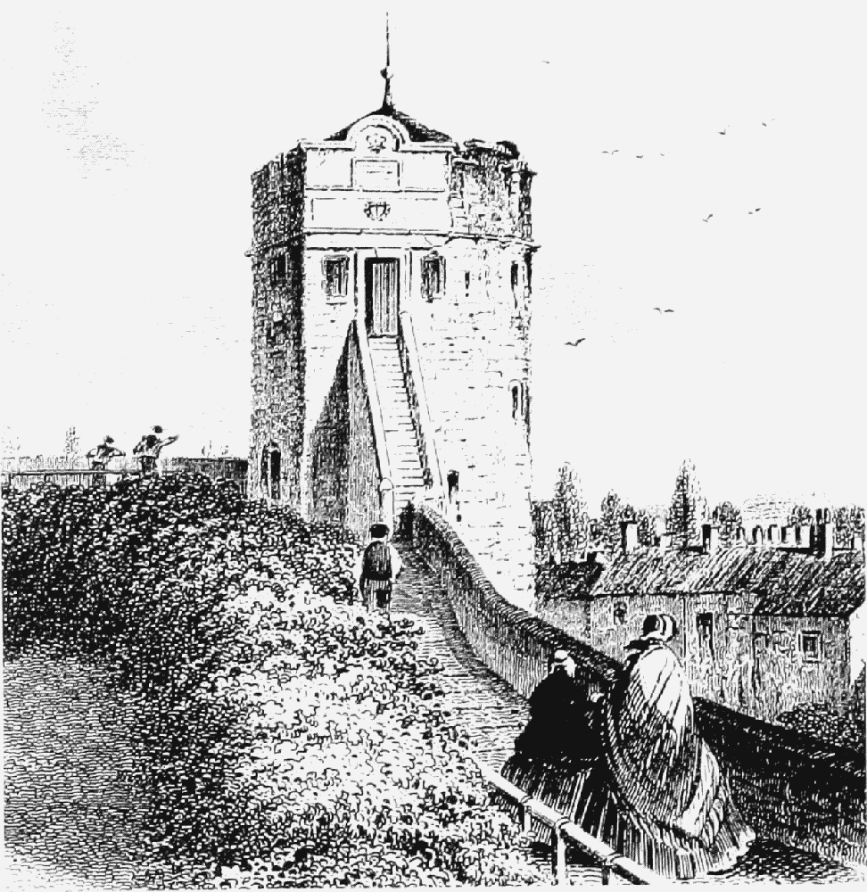
Phoenix (formerly Newton, later King Charles's) Tower
By the later 16th century the tower was leased jointly to two city companies, the Painters and Stationers and the Barbers and Chandlers, who themselves occupied the upper storey and sublet the tower to other guilds. In 1612, when the tower had lost the lead from its roof and was almost ruinous, the two companies began its restoration. (fn. 99) A phoenix, emblem of the Painters, appears above the lower door. During the siege the tower had a gun in each storey and as a result was badly damaged. It was returned in 1658 to the companies, who carried out extensive repairs and continued to maintain it until c. 1773, when they abandoned it as a meeting place. (fn. 100) Further repairs were done by the city in 1773, but it was again described as dilapidated in 1838. (fn. 101) With the rise of tourism from the 1840s the tower was promoted as an attraction because of a supposed association with Charles I, who had allegedly stood on the roof to watch while his army was defeated at Rowton Moor in September 1645. In the early 1850s the lower room was occupied by a print-seller, and from the late 19th century the tower housed a small private museum. By then it was commonly known as King Charles's Tower. (fn. 102)

Northgate
Morgan's Mount, 1903
Northgate
Recorded from the later 12th century, (fn. 103) the gate was granted in the time of Earl John (1232–7) to Robert of Anjou, in whose family the serjeanty remained throughout the 13th century, together with the Northgate gaol. (fn. 104) In the early 14th century Robert's greatgreat-grandson granted his rights to John Blund of Chester. (fn. 105) After 1360 the office passed by marriage to the Dutton and Derby families and in 1491–2 it was held by three co-heiresses of the Derbys. In 1498–9 the mayor and citizens laid claim to the Northgate, and by 1541 it was in the custody of the city sheriffs, with whom it remained until its demolition. (fn. 106)
The medieval Northgate comprised a narrow passage and pedestrian postern flanked by square towers, together with the gaol buildings. (fn. 107) Ruinous in 1617, it continued to be regarded as unsatisfactory until its demolition in 1808, after which it was replaced by a neo-classical arch, designed by Thomas Harrison and completed in 1810. (fn. 108)
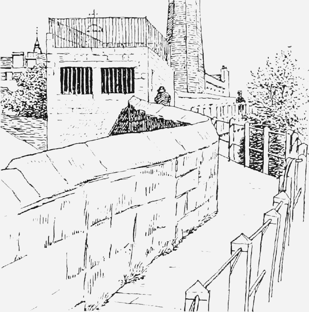
Pemberton's Parlour
Morgan's Mount
A watch tower probably preceded the building standing in 2000, which contains no medieval features and consists of a small chamber on the walls and a platform above, evidently a solid structure. Severely damaged during the siege, when it was converted into a battery, it was thereafter repaired. (fn. 109) The Mount was 'improved' in 1825. (fn. 110) Beside it is an arch opened in the early 19th century to facilitate access to the canal. (fn. 111)
Pemberton's Parlour
In the reign of Henry VIII the medieval watch tower on the site was known as Dille's Tower. (fn. 112) Later it became known as Goblin Tower, and was said to have been held by the Weavers' company. (fn. 113) It was apparently reconstructed in the early 18th century, and thereafter was used by John Pemberton, a ropemaker, to keep watch over his men working below. It fell down in 1893, and in 1894 was entirely rebuilt. (fn. 114)
Bonewaldesthorne Tower
A watch tower existed on the site by 1322, when the New Tower was built near by. (fn. 115) An irregular pentagon, it provided access to the walk along the spur wall to the New Tower. A blocked arch in the north wall near the tower, recorded in the early 19th century, was probably the remains of a postern giving access to the medieval harbour. (fn. 116)
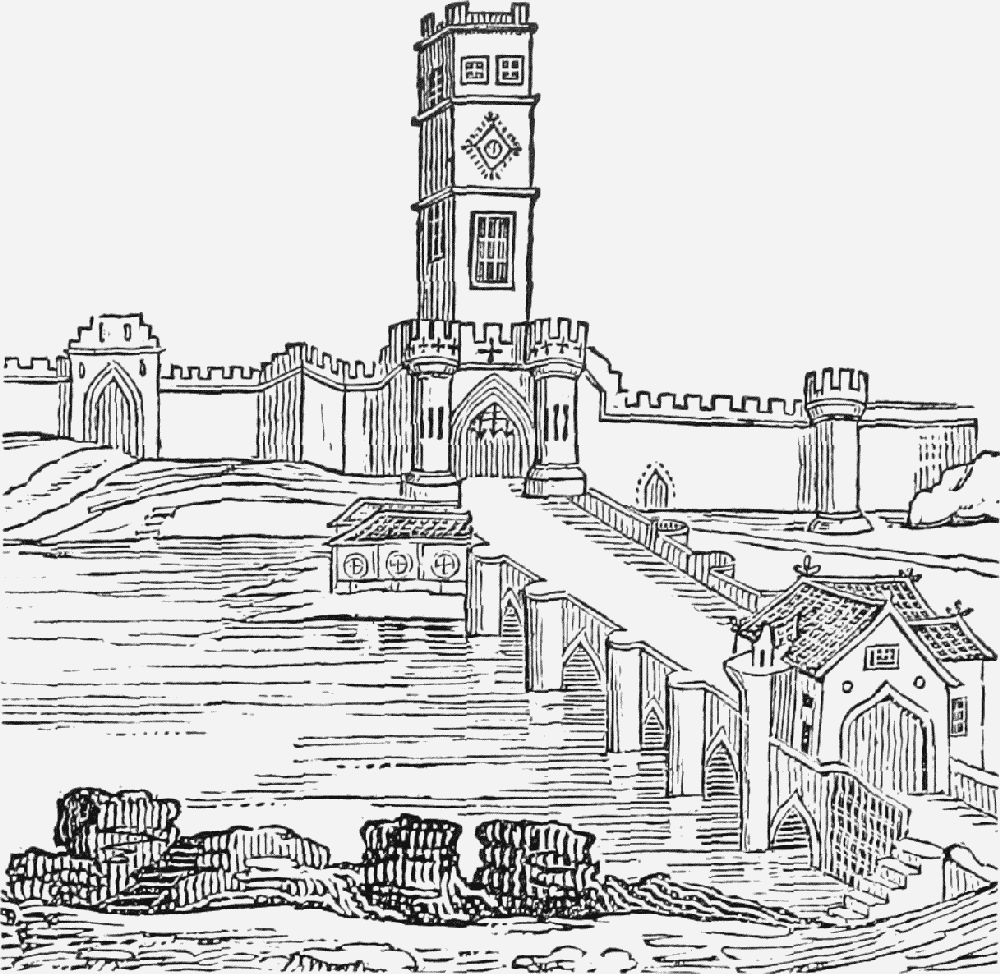
Water (New) Tower
The round tower, which John of Helpston contracted to build in 1322 for £100, is joined to the main defences by a massive spur wall over 30 m. long, under which is a water gate restored in 1730. Many of the details show parallels with Edwardian works in Wales, particularly Conwy where there was a similar water tower. The tower was intended to be 'in the water of Dee', but had been left high and dry within a century. (fn. 117) By the 17th century it had long been abandoned, and in 1631 the Bakers' company offered to rent and repair it with the help of the city authorities. (fn. 118) In 1639 it was renovated at the city's expense, (fn. 119) and in the 1640s embrasures in the spur wall were converted into gun ports. (fn. 120) Leased as a storehouse in 1671, (fn. 121) the tower continued to be employed for similar purposes for much of the succeeding century, but in 1728 was described as useless and neglected. (fn. 122) In 1825 the corporation decided to improve it, and in 1837 it was leased as a museum, a function it generally retained thereafter. (fn. 123) The name Water Tower came into use in the 17th century and displaced the original name of New Tower, despite the Assembly's attempt in 1732 to insist on using the correct name. (fn. 124)
Watergate
Although Watergate Street was so named by c. 1220, the earliest references to the gate itself, in the late 12th century and 1249, allude simply to the 'west gate'. (fn. 125) In 1249 the gate was said to have been held by the ancestors of Christine la Paumere, whose husband had been deprived of it by Philip of Orby (justice of Chester c. 1208–29), when he found the gate open before the proper hour. Philip had taken the gate into the earl's hand, and in 1249 it remained the king's. (fn. 126)
About 1270 Adam, son of Bernard of Salisbury, citizen of Chester, held the serjeanty of the Watergate by hereditary right. (fn. 127) Thereafter it passed through several hands until eventually, after 1432, it came into the possession of the Stanley family, who sold it to the city c. 1778. (fn. 128)
Tolls taken at the gate included fish, in the 13th century shared with one of the friaries. (fn. 129) By the later 15th century, however, takings appear to have been negligible. (fn. 130) In 1432 the yearly value of the serjeanty was 4s. (fn. 131)
The medieval gate consisted of a single Gothic arch and a small postern for pedestrians; whether it ever had towers is uncertain, but in the later 17th century it was described as a plain gate with a walkway over it. (fn. 132) In 1712–13 it was enlarged and rebuilt by the murengers, (fn. 133) and in 1760 a foot passage was constructed. (fn. 134) The corporation ordered the tollhouse at the gate to be demolished in 1782 and in 1788 the gate itself was replaced by a single neo-classical arch designed by the architect Joseph Turner, a member of the Assembly since 1776. (fn. 135)
Nuns' Gardens Postern
In the later 17th century the postern was said to have been granted to the prioress of Chester to facilitate access to her croft in the Roodee. (fn. 136) As late as 1718 burials were recorded 'nigh the Nun Gate'. (fn. 137)
Castle Postern
In the later 17th century the postern was described as 'an ancient port made for the benefit of them as lived in the castle to go to the river'. It was located by the castle ditch near the south-west corner of the defences not far from the Shipgate. (fn. 138)
Lowse Tower
A watch tower of that name faced the Roodee in 1573. (fn. 139)
Shipgate
The gate probably existed by the 1120s, and certainly by the 1270s. (fn. 140) In the 17th century it was said to have been opposite a ferry pre-dating the Dee Bridge. By the 14th century, when tolls were levied there, the gate was in the care of the keeper of the Bridgegate, who was bound to find a man to open and shut it. Dues were still charged there in the reign of Henry VI, but by 1534–5 it had been made 'useless', and in the reign of Edward VI it was blocked. (fn. 141) The gate, which comprised a single arch with battlements, was still standing in the later 16th century, but in 1707 was referred to in terms which imply that it had recently been removed. (fn. 142) If so, it must have been replaced, for it was expressly said to have been taken down in 1828 and was later re-erected in the garden of a house in Abbey Square. (fn. 143) In 1893 it was presented to the Chester Archaeological Society, and in 1897 was moved again by the city corporation to the Groves, where it remained in 2000. (fn. 144)
Bridgegate
Although in the late 12th century it was referred to simply as the south gate, (fn. 145) land near the Bridgegate and possibly the serjeanty of the gate had been given before 1150 by Countess Maud of Chester to her servant Poyns, probably keeper of the castle gardens. (fn. 146) The serjeanty and the keepership of the gardens remained combined throughout the 13th century. In 1269 Richard Bagot granted the serjeanty to Philip the clerk, (fn. 147) and thereafter the office was held by Philip's heirs, the Raby family, half from the heirs of the Bagots and half from the heirs of the Hose family. (fn. 148)
By 1321 tolls were levied at the gate, (fn. 149) and in 1349–50 the gate was said to have been worth 20s., in return for which the holder was obliged to find a man to keep it, the Shipgate, and the Horsegate. On the death without heirs in 1384–5 of Philip of Raby's daughter Catherine, the serjeanty remained divided into two shares, one of which, together with the castle garden, later passed to the Troutbecks and in 1521–2 to the Talbots, earls of Shrewsbury. (fn. 150) Both shares were eventually acquired by the city in 1624 and 1666. (fn. 151)
Shipgate, before 1828
The medieval Bridgegate, which comprised a Gothic arch flanked by two round towers, was much altered in 1600–1 by the addition of a tall square tower housing machinery for conveying river water to the city. It was known, after its builder, as John Tyrer's Water Tower, and was destroyed in the siege of Chester. A new octagonal tower was afterwards erected, perhaps on a different site immediately behind the gate, but was disused by the late 17th century and was demolished in 1782. (fn. 152) The gate itself was repaired in 1640, and in 1645 an assessment was levied for building a drawbridge. (fn. 153) In 1728 the structure could still be described as an 'ancient, strong, and spacious stone building'. (fn. 154)
Repairs and improvements were considered in the 1770s, but in 1781 the old gate was taken down to be replaced by a classical arch with a balustraded parapet designed by Joseph Turner (d. 1807). (fn. 155) Steps leading from the gate into Skinners Lane were built in 1831. (fn. 156)
Newgate, 1903
Capelgate (Horsegate)
The gate, a postern east of the Bridgegate in being by 1321, was in the custody of the Bridgegate's serjeant. (fn. 157) Its primary object seems to have been to allow horses to be watered on the river bank. (fn. 158) Apparently only a modest archway in the wall, the gate was still standing in 1708. (fn. 159) In 1745 it was blocked, as part of the defensive measures taken against the Young Pretender. (fn. 160)
Postern Tower
A round battlemented watch tower east of Capelgate existed by the 1580s and was still standing in 2000. (fn. 161)
Newgate
Watch Tower
A watch tower standing at the top of what later became the Wishing Steps was converted into a 'large, square, solid mount' to form a gun battery in 1643. Later furnished with a stone seat and windows commanding the view over the river, it was reduced in height in 1826 and entirely removed in 1843. (fn. 162)
Newgate (Wolfgate, Wolfeld's Gate)
The early name, Wolfeld's Gate, derived from a personal name, and occurs first in the late 12th century. (fn. 163) The gate lay adjacent to the point where Fleshmongers Lane, an early thoroughfare, breached the southern legionary wall and may date from before 1066. (fn. 164) No tolls were payable in 1321, though in 1754 tolls were said to have been taken from time immemorial. (fn. 165) The gate was the property of the city corporation in the later Middle Ages, and in 1489–90 was leased to a glover. (fn. 166) In 1573, after the abduction of an alderman's daughter, the city authorities ordered that it be shut at night. (fn. 167)
The medieval gate, which seems to have been set in a square tower, was repaired in the 1550s, but was condemned in 1603 as too narrow. At the order of the Assembly it was enlarged, but in the following year it was found to be in poor repair, and in 1608 it was taken down and entirely rebuilt. (fn. 168) The new gate was given a new door in 1640 and further repaired in 1651. (fn. 169) In 1674 a house in the form of a tower was built on the north side to be 'a defence and security to the gate if occasion should require', (fn. 170) and in 1768 the gate itself was again rebuilt by the murengers, presumably as a single round arch, the form which it retained in 2000, when it was generally referred to as Wolfgate. (fn. 171) In 1938, as part of a road-widening scheme, a new gateway with two towers, designed by Sir Walter and Michael Tapper, was built immediately to the south. (fn. 172)
The Bars, before 1767
Thimbleby's Tower
A medieval watch tower, known in 1555 as Wolf Tower, it had an octagonal stone vault, built probably c. 1300, at the level of the wall walk. Rented by the Gamull family from the corporation in the earlier 17th century, it was a 'ruinous old place' until 1643, when it was put into repair during the siege. It may then have sustained damage, since in 1651 the Gamulls were asked to pay for repairs. In the late 17th century it was described as 'of no great use', and in the 18th century it served as a laundry. (fn. 173) The tower was repaired in 1879. (fn. 174) In 1994 it was given a steeply pitched tiled roof. (fn. 175)
Outlying Gates and Defences
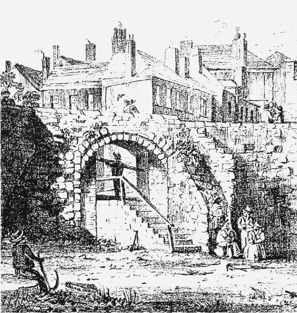
The Bars
The gate, which had been built by 1241, stood east of the city on Foregate Street near the later junction with City Road. (fn. 176) By the 17th century it had become a hindrance to traffic, and in 1609 a postern for pedestrians was inserted on the north side. The whole structure was demolished in 1767. (fn. 177)
Further Bridgegate, before 1784 (foreground)
Further Bridgegate (Dee Bridge Tower)
In 1387 Richard II directed that the profits of the murage and the ferry across the Dee were to be applied to the rebuilding of the Dee Bridge. (fn. 178) The work was not finished until 1407, when Prince Henry ordered that the tower on the bridge, begun in Richard's time, was to be completed. (fn. 179) By the 1590s it had become dilapidated and was replaced by a gatehouse, itself demolished in 1784. (fn. 180)
Cow Lane Gate
The gate, a single tall archway spanning the street, was built in 1630 and taken down in 1773. (fn. 181)