A History of the County of Middlesex: Volume 11, Stepney, Bethnal Green. Originally published by Victoria County History, London, 1998.
This free content was digitised by double rekeying. All rights reserved.
'Bethnal Green: Dog Row', in A History of the County of Middlesex: Volume 11, Stepney, Bethnal Green, ed. T F T Baker (London, 1998), British History Online https://www.british-history.ac.uk/vch/middx/vol11/pp101-103 [accessed 30 April 2025].
'Bethnal Green: Dog Row', in A History of the County of Middlesex: Volume 11, Stepney, Bethnal Green. Edited by T F T Baker (London, 1998), British History Online, accessed April 30, 2025, https://www.british-history.ac.uk/vch/middx/vol11/pp101-103.
"Bethnal Green: Dog Row". A History of the County of Middlesex: Volume 11, Stepney, Bethnal Green. Ed. T F T Baker (London, 1998), British History Online. Web. 30 April 2025. https://www.british-history.ac.uk/vch/middx/vol11/pp101-103.
DOG ROW.
In the 1570s a broad area of waste stretched from Mile End to Bethnal green, through which the later Cambridge Heath Road ran from north to south. (fn. 1) In 1582 Thomas, Lord Wentworth, made three grants of waste on the west side of the road, initially as copyhold but converted to 500-year leases in 1585. The plots were 30-57 ft. with frontages from north to south of 120 ft., 120 ft., and 450 ft. respectively. Between 1582 and 1585 one house had been built on the first plot and two houses on the second. In 1585 Henry, Lord Wentworth, leased for 500 years another plot to the south, measuring 495 ft. by 66 ft. The southernmost plot, abutting Mile End green and including a house, was leased out for 40 years by Thomas, Lord Wentworth, in 1621. By 1652 there were 39 houses or cottages (fn. 2) in what by 1649 was called Dog Row. (fn. 3) By 1671 there were 46. (fn. 4) In 1652 at least 16 buildings were of brick and the southernmost one had six rooms, although most of the others were very small. (fn. 5) In 1671 two houses in Dog Row were assessed for 5 hearths, three for 3 hearths, 33 for 2 hearths, and eight for only one hearth. (fn. 6) The 39 dwellings of 1652 included two public houses, the Dun Cow and the White Bear, and farm buildings were associated with 11. Some of the tenements had sheds, (fn. 7) possibly the dog kennels which gave their name to the road, and which survived, blocked up and stuccoed, on the front of nos. 65-76 Cambridge Road c. 1930. (fn. 8)
Building was on a small scale, the five leases being held in 1652 by 11 intermediate tenants who had probably built most of the dwellings, which they sublet. (fn. 9) Another two houses were built on the northernmost plot between 1659 and 1665 and two more between 1677 and 1679. (fn. 10) Sales of wastehold in the Interregnum (fn. 11) were usually to the existing intermediate tenants, most of them local inhabitants. Other tenants and purchasers were a London goldsmith, (fn. 12) a Kentish 'esquire' (fn. 13) and a yeoman of the Minories (Peter Smith). (fn. 14) It was probably the latter's son William Smith, a London merchant, who engaged a bricklayer and carpenter to replace decayed houses with three new houses c. 1679. (fn. 15)
In 1671 Lady Wentworth and Sir William Smyth granted another plot, to the south of the existing wastehold plots, for 99 years to Henry Meacock, blacksmith of Mile End. A house there, occupied with c. 3 a. of garden by Walter Simkins in 1703, passed in 1709 to Capt. Robert Fisher, who founded almshouses on the site in 1711. (fn. 16)
In 1673 Lady Wentworth was licensed to build on West Heath, the waste named by 1475 (fn. 17) on either side of Mile End Road, which included the portion in Bethnal Green around the southern part of Dog Row. Sir Christopher Wren, as surveyor for the licence, depicted the plague burial ground on the west side of Dog Row, and 'ancient houses' on the east, at the junction with Mile End Road. By 1703 houses fronted Mile End Road on both sides of the junction, as projected by Wren. Those on the west lay within Bethnal Green. (fn. 18)
Houses on the east side of Dog Row were part of property owned by Sir William Smyth of Stepney, Bt., who leased a brick house and 1 a. in 1678 to Abraham Neale for 200 years (fn. 19) and another house and ground in 1689 to Matthew Walker, cowkeeper. (fn. 20) By 1703 there were four buildings, the most northerly in the fork between Dog Row and Red Cow Lane, the most southerly, Walker's, opposite what was to become Darling Row; between were two smaller buildings, one of them probably Neale's house. (fn. 21) Smyth's property and Neale's house passed to Joseph Jorey, whose estate consisted in 1728 of four brick houses, farm buildings, and c. 6 a. (fn. 22) Neale's 1 a. passed to the Leeds family. (fn. 23)
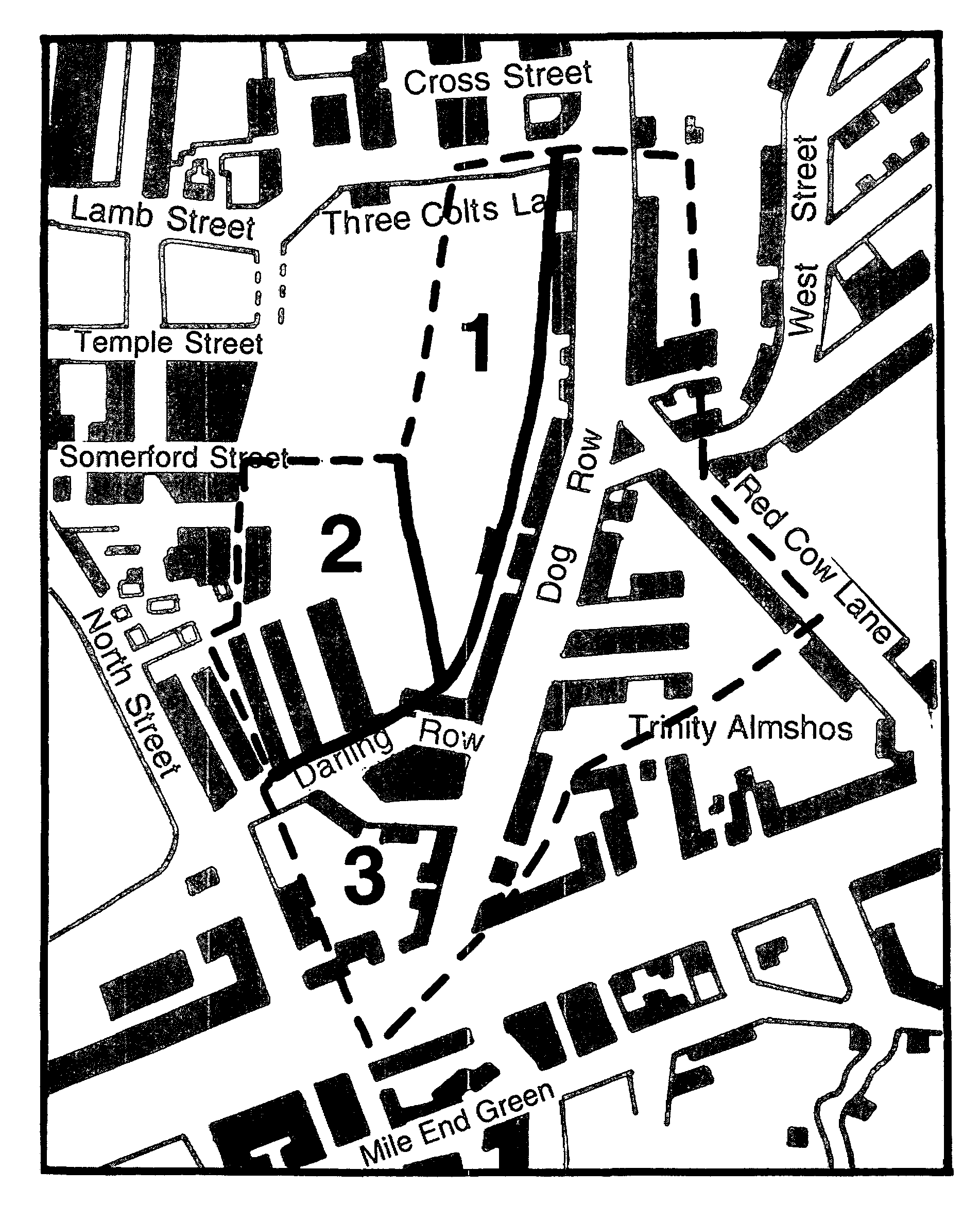
Dog Row: principal estates
1 Fulmore Close, 2 Naylor, 3 Simkins Gardens
In 1695 Trinity House founded almshouses to the south of Smyth's and Neale's estates, just outside Bethnal Green. (fn. 24) Thereafter it acquired additional sites within Bethnal Green: waste ground next to Fisher's almshouses in 1723, (fn. 25) two almshouses built by William Ogborne nearby in 1725, (fn. 26) Fisher's almshouses by 1732, (fn. 27) and Walker's farm buildings, which adjoined Trinity almshouses, in 1805. (fn. 28) Capt. Fisher's almshouses, still there in 1838, had gone by 1850. (fn. 29)
There appears to have been little change in Dog Row during the early 18th century, with three farms on the eastern side and probably one, at the entry to fields (called Mile End Corner at the end of the century and later Darling Row) on the west. A terrace replaced some of the scattered houses farther north on the west side. (fn. 30)
In 1765 David Wilmot took a lease of ground on the east side of Cambridge Road, before it branched into Dog Row and Red Cow Lane, where he built several houses within a year. (fn. 31) In 1775-6 at least five houses were built opposite them by Flaw, a bricklayer, in Queen's (or Charlotte) Row, (fn. 32) which by 1783 formed a complete terrace. (fn. 33) Beardwood or Barwood, a builder, erected 16 houses in Dog Row in 1766-81, (fn. 34) and another 4 in 1783, (fn. 35) Galton built 5 there in 1788-9, (fn. 36) and Dodd and Wyers two each in 1802. (fn. 37) One Lara built 4 houses 'near Dog Row' in 1783, (fn. 38) possibly at what was called Mile End Corner in the 1790s. (fn. 39) Purim Place on the east side of Dog Row was built opposite, south of Walker's estate, c. 1783. (fn. 40) Griffin's Place, brick cottages encroaching on the waste, existed nearby when the Corporation of Trinity House purchased Walker's farm in 1805. The Corporation granted a 70-year building lease to Plunkett, a timber merchant who built third-rate houses there. (fn. 41)
The dairy farms north of Trinity House's estate, on the east side of Dog Row, mostly farmed by John Johnson, were given over to the builders, John Jenkins of Whitechapel and Thomas Oliver of Thomas Street, from 1808 to 1813. Houses were built fronting west on Dog Lane, east on Red Cow Lane, and in new streets (John, originally Johnson, and Thomas streets). (fn. 42) Building also spread on the west side of Dog Lane behind the waste holdings fronting the main road. Darling Row (formerly Mile End Corner), perhaps named after Sir Robert Darling, a local official of 1769, (fn. 43) and Lisbon Street (existing by 1811) (fn. 44) ran westward to join North Street and Collingwood Street ran northward. William Green, a Spitalfields builder, and John Reynolds and John Dible, both local men, were responsible for much of the building there between c. 1810 and 1825. (fn. 45) In 1818 Green bought 6 a. of Fulmore Close to the north, (fn. 46) on which he built Northampton Street by 1828 (fn. 47) and Norfolk and Suffolk streets by 1836. By 1836 there were nearly 500 houses in Dog Row district: 80 houses and two public houses fronted the main road on the west, with 249, three public houses, a brewery, a factory, and a slaughter house in the streets behind; 73 houses and two public houses fronted the main road on the east, with 92 houses behind. (fn. 48)