A History of the County of Middlesex: Volume 11, Stepney, Bethnal Green. Originally published by Victoria County History, London, 1998.
This free content was digitised by double rekeying. All rights reserved.
'Bethnal Green: The Green, Bethnal Green Village', in A History of the County of Middlesex: Volume 11, Stepney, Bethnal Green, ed. T F T Baker (London, 1998), British History Online https://www.british-history.ac.uk/vch/middx/vol11/pp95-101 [accessed 30 April 2025].
'Bethnal Green: The Green, Bethnal Green Village', in A History of the County of Middlesex: Volume 11, Stepney, Bethnal Green. Edited by T F T Baker (London, 1998), British History Online, accessed April 30, 2025, https://www.british-history.ac.uk/vch/middx/vol11/pp95-101.
"Bethnal Green: The Green, Bethnal Green Village". A History of the County of Middlesex: Volume 11, Stepney, Bethnal Green. Ed. T F T Baker (London, 1998), British History Online. Web. 30 April 2025. https://www.british-history.ac.uk/vch/middx/vol11/pp95-101.
THE GREEN: BETHNAL GREEN VILLAGE. (fn. 1)
The earliest area of settlement was probably around the green, particularly in the north-east near St. Winifred's well and St. George's chapel, the area possibly identifiable with the original 'bright or Blitha's corner' (Blithehale). (fn. 2) The village was defined on the east by Rushy (Russia) Lane and the Back Lane (Globe Road), which separated it from the demesne lands and open fields. Besides medieval cottages around Barnard's Lane (Old Ford Road), (fn. 3) St. George's chapel stood by 1512 in an inclosure on the green at the western corner of the lane and what later became Victoria Park Square. (fn. 4) There were added, by the 16th century and probably earlier, a few larger houses, the retreats of courtiers or merchants from London. The Corner House, the capital messuage of Pyott's estate, stood by 1538 on the eastern corner of Barnard's Lane opposite the chapel; it was later rebuilt and extended. (fn. 5) By c. 1550 Sir John Gresham's house, rebuilt as Kirby's Castle in the 1570s, adjoined the green just south of Green Street. (fn. 6) The estate included a farmhouse which had dwindled to a cottage by 1577. (fn. 7)
Most of the green itself was preserved by the purchase in 1678, by Thomas Rider and other owners and occupiers of neighbouring houses, of 11 a. of waste east of Cambridge Heath Road and ½ a. to its west to prevent any new building. It was let out as three closes of farmland, (fn. 8) and in 1690 was settled in trust for the poor. (fn. 9) The purchase apparently succeeded in keeping humble building at bay while encouraging gentry, several of whom were said in 1688 to have come to live there since the inclosure. (fn. 10)
Though from the late 16th century piecemeal development began to fill in the empty plots around the green, eventually extending back from it in all directions, even in the 18th century, while much of the rest of Bethnal Green was being covered with small houses for weavers, the area around the green remained socially superior. Contemporary descriptions and illustrations suggest that Gascoyne in 1703 confused two houses at the northern end of the green, the capital houses respectively of the Dickens and Pyotts estates. The large, winged house depicted at the northern corner of Cambridge Heath Road and Old Ford Road should probably have been shown on the site of the Corner House at the north-east corner of Old Ford Road and Victoria Park Square, while the smaller threegabled house depicted there (fn. 11) was probably Lyons Hall, demolished c. 1794. (fn. 12)
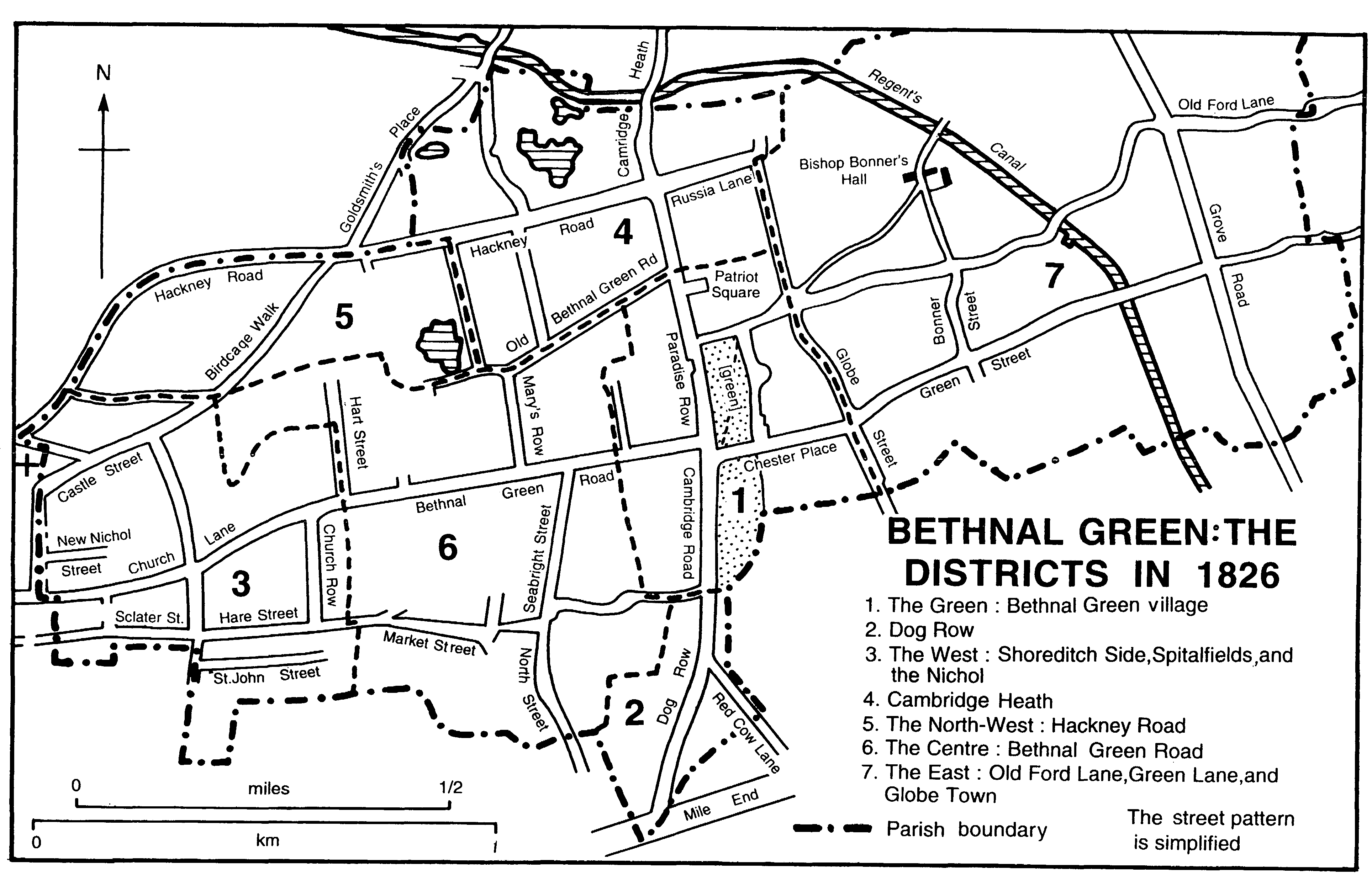
BETHNAL GREEN
THE DISTRICTS IN 1826
In 1751 there were some 65 houses around the green on the eastern side of Cambridge Heath Road and 93 on the western side. Those on the western side were overwhelmingly small houses, 84 per cent being rated at £5 or less a year, compared with 53 per cent on the eastern side; 11 per cent were rated at £6-£10 compared with 33 per cent on the east. There were two houses on the west rated at £11-£15 compared with five on the east, and only one large house on the west, rated at £16 compared with one house rated at £16 and two at £30 on the east. (fn. 13)
The following paragraphs trace the piecemeal expansion of settlement round the green beginning at its northern end. North of the green and the later Old Ford Road were copyhold houses belonging to the Dickens family, probably by 1614, on a site bounded west by Cambridge Heath Road, north and east by Conduit Close. (fn. 14) In 1637 Nicholas Dickens (d. 1653), a London haberdasher, built a house on the green south of his copyhold property (fn. 15) and by 1661 the estate contained two tenements and five cottages. (fn. 16) In 1763 it had a large house on the corner site, a house with a large garden north of it, and five houses running eastward from the corner house along the north side of Old Ford Road. (fn. 17) The Dickens estate experienced the first extensive building: Aaron Eele, of Mile End New Town and Daniel Bowyer of Whitechapel were building in Patriot Square in 1792-4 (fn. 18) and, joining it to the west where it fronted Cambridge Road, Patriot Row was built about the same time. (fn. 19) Among those buying the new houses were an employee of East India House, a Whitechapel brandy merchant, a Covent Garden coal merchant, and a City gentleman. (fn. 20)
East of the Dickens estate lay Conduit close, part of Pyotts. In 1643 that estate included several cottages, tenements, and tofts which were probably old (fn. 21) and in 1734 six ruinous wooden houses stood north of Old Ford Road. (fn. 22) One was the Hampshire Hog, probably the Hog and Pye licensed in 1722. (fn. 23) The others perhaps included three old houses on the estate leased to the Revd. John Lawrence and Roderick Patcheco, one of the Jews living in the vicinity who gave rise to the name Jews' Walk for the western end of Old Ford Lane. When Pyotts was broken up and sold in 1753, the houses were bought and pulled down by Anthony Natt. (fn. 24) He replaced them with a three-storeyed terrace (originally 10-12, renumbered in 1875 as nos. 17-21 (odd) Old Ford Road), (fn. 25) still there in 1988. The Hampshire Hog continued to be licensed until 1775, perhaps not in its old building. (fn. 26)
Natt (d. 1756), a carpenter who had built on Nichol and Carter estates in the 1720s and 1730s, (fn. 27) bought what was described as the chapel house in 1748 and shortly afterwards built two houses adjoining it to the west. (fn. 28) In 1772 his son Anthony Natt, rector of Netteswell (Essex), bought the freehold from the lord of the manor (fn. 29) and in 1790 employed Ruby, a carpenter, to replace the two houses with four, forming the Terrace, Old Ford Road. (fn. 30)
On the east side of the green and south of the Corner House, at least by the 17th century and probably earlier, several houses faced the green, with their tofts and crofts stretching to Back Lane. By 1703 a lane (later Victoria Park Square) ran from Old Ford Road to Green Street in front of the houses. (fn. 31) Three houses were built on the ground next to the Corner House, probably fronting Victoria Park Square, c. 1736. (fn. 32) The Corner House itself was renamed Aldgate House after 1753, later occupied by prominent Jews, and demolished in 1806. (fn. 33)
On the site later occupied by nos. 21-23 Victoria Park Square stood, possibly by 1621, the Wheatsheaf, in 1662 two cottages associated with another tenement as part of John Stonier's estate. (fn. 34) Two houses were associated with Markhams by 1654: (fn. 35) the Blind Beggar at the southern end and, possibly on the site of no. 18, the house then occupied by Edward Pratt and in 1659 perhaps by one of the joint owners, Waldrof Lodowick, a London merchant. (fn. 36) South of the Blind Beggar, between it and Green Street, were two tenements and a cottage by 1647: (fn. 37) they were four tenements by 1683, (fn. 38) held with 4 a. stretching eastward to Back Lane. (fn. 39) North of the Blind Beggar were, by 1668, a tenement and three cottages, (fn. 40) which by 1688 had become six tenements. (fn. 41) Nearby houses in 1688 included five tenements associated with Eastfields (fn. 42) in 1657 and a messuage and three tenements belonging to Hawes in 1659. (fn. 43) Both estates passed through the hands of the Grunwins before they were divided at the beginning of the 18th century. (fn. 44) In 1692 James Grunwin, a merchant tailor, leased to Peter Causton, another London merchant, a house with nine rooms, a banqueting house which was probably separate, a summer house, and a two-seated latrine. (fn. 45) The house may have been that occupied by Robert Edmunds, assessed for 4 hearths in 1664, (fn. 46) which, together with cottages, occupied the site later known as nos. 19 (fn. 47) and 20 Victoria Park Square (fn. 48) and passed to the Goulds. (fn. 49) A Jew, Jacob Cohendezevedo, occupied it before 1769. (fn. 50) The rest of the property was sold in 1701 to Joseph Blissett, (fn. 51) who from 1693 accumulated fractions of Markhams (fn. 52) which by 1687 included a house called the Sugar Loaf. (fn. 53) Blissett may have built nos. 16-18, a brick and tiled range of two storeys with cellars and attics and pilastered doorways of c. 1700. (fn. 54)
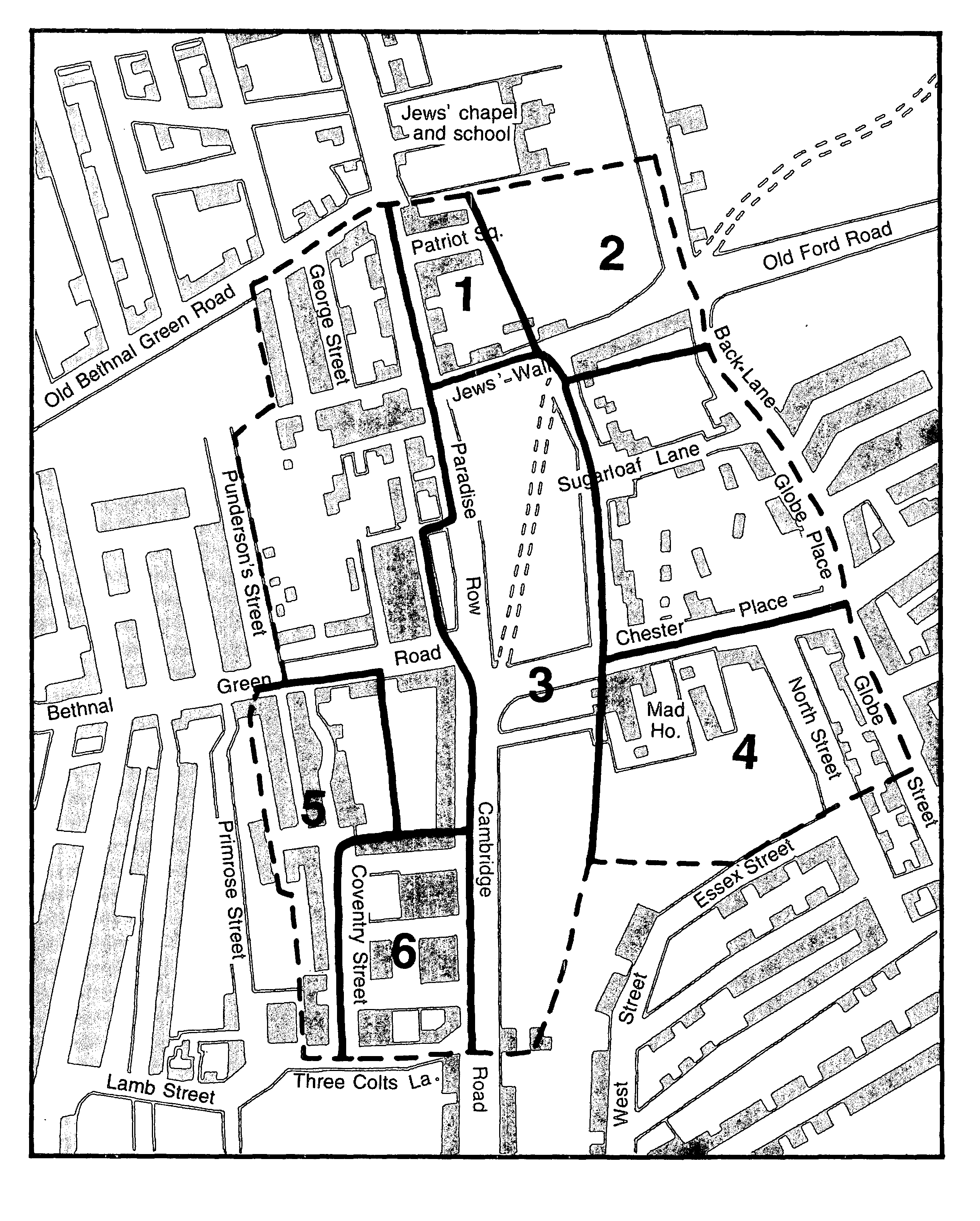
Bethnal Green village: principal estates
1 Dickens, 2 Pyott, 3 Poor's Lands, 4 Kirby's Castle, 5 Penn, 6 St. Paul's. The boundary is that of the district in 1826
Sugar Loaf Walk, which joined Victoria Park Square to Back Lane by 1703, (fn. 55) probably marked the boundary of Blissett's and Gould's estates. Goulds, to the north, was split up in 1769. Cohendezevedo's house passed to Peter Mestear, who built another in the garden and enfranchised both in 1772. (fn. 56) In 1779 Mestear acquired, on the south side of Sugar Loaf Walk, from Blissetts four houses (fn. 57) which had existed by 1744 (fn. 58) and were probably those depicted in the alley in 1703. (fn. 59) An old garden of Goulds was bought by David Home, a peruke maker, who had bought two houses on the neighbouring Stonier estate in 1757. (fn. 60) He built a new house and obtained the enfranchisement of all three houses, probably on the site of no. 21, in 1772. (fn. 61) Further south three houses were built 'near the Blind Beggar' in 1788. (fn. 62)
Two or more tenements in Back Lane in 1653 had become six wooden cottages by 1674. (fn. 63) They were split into two estates in 1720, (fn. 64) the northern three with an added one becoming nos. 11-14. (fn. 65) The southern three had been replaced by two partly brick houses by 1734 (fn. 66) and there were another two by 1766. (fn. 67)
South of Green Street Kirby's Castle had wealthy occupants throughout the 17th century. (fn. 68) From 1726 the house, by then misleadingly called the Blind Beggar's House, was a private lunatic asylum. (fn. 69) It was extended and by 1777 was called the White House. (fn. 70) In 1685 the owner James Alpha agreed to build a two-storeyed and garretted house for John How, lessee of the former home farmhouse, then a cottage. (fn. 71) By 1698 the old farmhouse had been replaced by five brick tenements fronting the green south of Kirby's Castle, a terrace of four small houses, and almost on the southern border a detached house with 14 rooms, a brewhouse, and coach house, occupied in 1703 by the estate's owner Col. Joseph Jorey. (fn. 72) Jorey's house was by 1760 a workhouse (fn. 73) and, of the terrace of four houses, one had been pulled down by 1802 and the others converted into two, owned by the widow of the 'keeper of lunatics'. (fn. 74)
The western side of the green apparently had no settlement before the 16th century. Shortly before 1581 John Soda, a London grocer, built a house on the waste west of Cambridge Heath Road, slightly south of Cambridge Heath, (fn. 75) for which his widow Joan obtained a 500-year lease from Henry, Lord Wentworth, in 1585. (fn. 76) It remained the most northerly of the houses on the west side of the green in the 17th century, and in 1652 was a 'great messuage' with an adjoining tenement, courtyards, gardens, and 1 a. of pasture containing fruit trees and 32 elms. (fn. 77) Called the City of Nineveh in 1713, when William Coleman owned it, (fn. 78) it may have been the winged house depicted in 1703 opposite Old Ford Road or a smaller house to the north. (fn. 79) In 1722 William Spering's daughters conveyed at least part of Coleman's estate to George Colson, a London carpenter. (fn. 80) Colson probably built George Street, which ran southward from Old Bethnal Green Road, parallel with Cambridge Heath Road, where in 1726 he leased building plots fronting east onto it. (fn. 81) In 1740 he leased to a butcher a shop 'lately built' and ground called 'the Grove'. (fn. 82) By 1750 nine houses stood near the watchhouse, seven fronting east and two south on 'the Grove near Bethnal Green'. (fn. 83) The Grove may have been the belt of trees depicted running north alongside Cambridge Heath Road from the watchhouse in 1703. A row of houses already existed there in 1703, possibly the northern part of the later-named Paradise Row. (fn. 84) The group of very small houses opposite Old Ford Road, Little George Street and Peacock Court or Place, apparently existed by the mid 18th century, (fn. 85) possibly earlier as the Peacock inn was there by 1730. (fn. 86) By the end of the century Paradise Row extended to Bethnal Green Road and Hollybush Place had been built to the west. (fn. 87) Another three houses were 'nearly finished' at nos. 7-9 Paradise Row in 1814. (fn. 88) From 1788 no. 3 Paradise Row housed Daniel Mendoza, the Jewish boxer. (fn. 89) In 1783 Capt. Jonathan Punderson was building Punderson's Place and Gardens on the narrow 2-acre strip running north from Bethnal Green Road to the west of Stainer's estate, (fn. 90) which had belonged to Nicholas Dickens. (fn. 91)
Other pieces of waste south of Soda's were granted as copyhold to London butchers in 1581. (fn. 92) They were probably the two parcels of waste which were leased by Thomas, Lord Wentworth, in 1614 for 50 years after the death of Lady Anne Wentworth (d. 1625), with a covenant to maintain buildings. By 1652 they contained three cottages and farm buildings, all built by the lessee, Timothy Rushbrook. (fn. 93) The property was sold in 1654 to John Spering, a local man (fn. 94) who let out one house in 1666 to John Harwood and in 1669 to Robert Hudson. (fn. 95) A second house, to the east of the first, was leased or sold shortly before 1667. In 1671 Spering left 1 a., a house in his own possession, one occupied by Hudson, two tenements, and cottages. (fn. 96)
Also west of the green William Sebright (d. 1620) occupied a house separated from St. Paul's estate to the south by 1½ a. of attached land. In 1625 Ellis Crisp, alderman, held the freehold. Dame Hester Pye, probably his widow, and his son Sir Nicholas Crisp leased the house and 2 a., and a further ½ a. of exotic trees beyond a little lane, to Balthazar Gerbier, (fn. 97) who opened his academy in the house. (fn. 98) Gerbier had started his English career when presented to James I by the Dutch ambassador Noel de Caron, who had earlier lived in Bethnal Green. (fn. 99) In 1655 Crisp sold his property to Robert Stainer, (fn. 100) who was assessed for as many as 12 hearths in 1664 (fn. 101) and 15 in 1671. (fn. 102) He was dead by 1678 when his land contained one or more houses west of the green. By 1703 there were two houses there, witheast of them a terrace of houses and gardens fronting the Poor's Land. (fn. 103)
From 1620 Walter Cooke, Master of Trinity House (d. c. 1656) (fn. 104) held 3 a. south of the lane which became Bethnal Green Road. By 1686 the land was used as a nursery by Matthew Penn, (fn. 105) who had a house at its northern end by 1696. (fn. 106) On the adjoining estate to the east terraced houses fronting Cambridge Road ran southward from the lane by 1703. (fn. 107) On the corner of the lane and Cambridge Road the Salmon and Ball stood in 1733. (fn. 108) The Green Man existed by 1750 in the middle of the terrace. (fn. 109) By 1764 five houses fronted Bethnal Green Road. (fn. 110)
As in other districts, the Napoleonic era saw piecemeal building make way for the development of whole estates. East of the green the 4 a. between Victoria Park Square and Back Lane had been fragmented by 1797 (fn. 111) and houses were being built in 1807 in Chester Place on the north side of Green Street, partly by Thomas Seares, a local bricklayer. (fn. 112) Thurlow Street existed by 1809, (fn. 113) as by 1826 did houses behind Chester Place in Helen's Place and the beginnings of Bernham or Burnham Square in the corner between Globe Street (Back Lane) and Sugar Loaf Walk. (fn. 114) Joseph Merceron accumulated property to the north between 1810 and 1833 but did not build. (fn. 115) On Peter Mestear's estate, centred on Sugar Loaf Walk, the White Hart brewery had been built by 1819. (fn. 116) At the northwest corner of Victoria Park Square and Old Ford Road Aldgate House was replaced by 1811 by Ebenezer or Park chapel and small tenements, (fn. 117) which by 1813 covered the whole frontage on Old Ford Road as far as Back Lane and Gretton Place. (fn. 118)
At the northern end of the green the houses at the end of Old Ford Road, on the Dickens estate, were rebuilt in the early 19th century as plain, three-storeyed houses in what was called Jews' Walk or North Side. (fn. 119) Pyotts to the east was leased for building in the 1820s when Bates Place fronting Old Ford Road, the west side of Russia Lane, and the new Providence Place were built. (fn. 120)
At the southern end the Kirby's Castle estate, occupying the whole area south of Green Street and west of Globe Road, was split up in 1809. Houses were soon built, some by Charles Pike, on the west side of Globe Road and fronting the new James or North Street and Cornwall Street. (fn. 121) A factory existed by 1817. (fn. 122) Kirby's Castle (the White House) remained an asylum; the Red House, a house designed for the insane, had been built to the south of it by 1831. (fn. 123)
St. John's church was built on the green at the junction of Cambridge Road and Green Street in 1828. (fn. 124)
On the west side of Cambridge Road the St. Paul's estate, bounded south by Three Colts Lane and long held on leases for lives by the Boon family, was 'in the hands of Blake and Mead in 1809. (fn. 125) Thomas Blewett Mead, a Shoreditch victualler, was involved in leasing new houses in Bath, Parliament, and Coventry streets and Cambridge Road in 1811 and 1813; (fn. 126) Blake was probably James Blake, an auctioneer from Bishopsgate Without and a developer of Nag's Head Field near Hackney Road in 1807- 8. (fn. 127) Part of the St. Paul's estate was acquired c. 1818 by John C. Severne, who gave his name to Severne or Abingdon Street. (fn. 128) Building was complete by 1826. There were 207 houses and one public house, the Queen Adelaide, on the estate in 1836. (fn. 129)
The Penn's Garden estate, a strip of 3 a. west of St. Paul's estate from the south side of Bethnal Green Road to Three Colts Lane, passed to the Lucas family in 1789. In 1811 Joseph Lucas leased it to Ann Potts (fn. 130) who granted 56-year leases of plots to local builders, among them William Timmins, John Pitt, and Francis Fuller. (fn. 131) By 1822 there were, besides the 17thcentury farmhouse fronting Bethnal Green Road, 106 houses in Lucas, Potts, Pitt, and Fox streets. (fn. 132) By 1836 there were 25 houses and the Lord Wellington on the southern part of the estate, on the north side of Three Colts Lane and in Primrose Street. (fn. 133) On the north side of Bethnal Green Road, Hollybush Gardens existed between Hollybush Place and Punderson's Gardens by 1818 (fn. 134) and contained four houses by 1836. (fn. 135) Rebuilding included the construction by John Litchfield of five houses on the site of old wooden houses, possibly George Colson's, on the north side of George Street, once called Nineveh Corner, after 1824. (fn. 136)
By 1836 Bethnal Green village had c. 289 houses, a public house, a brewery, and a factory on the east side of Cambridge Road and 401 houses and seven public houses on the west side. (fn. 137)