An Inventory of the Historical Monuments in the County of Northamptonshire, Volume 3, Archaeological Sites in North-West Northamptonshire. Originally published by Her Majesty's Stationery Office, London, 1981.
This free content was digitised by double rekeying. All rights reserved.
'Barby', in An Inventory of the Historical Monuments in the County of Northamptonshire, Volume 3, Archaeological Sites in North-West Northamptonshire(London, 1981), British History Online https://www.british-history.ac.uk/rchme/northants/vol3/pp12-14 [accessed 30 April 2025].
'Barby', in An Inventory of the Historical Monuments in the County of Northamptonshire, Volume 3, Archaeological Sites in North-West Northamptonshire(London, 1981), British History Online, accessed April 30, 2025, https://www.british-history.ac.uk/rchme/northants/vol3/pp12-14.
"Barby". An Inventory of the Historical Monuments in the County of Northamptonshire, Volume 3, Archaeological Sites in North-West Northamptonshire. (London, 1981), British History Online. Web. 30 April 2025. https://www.british-history.ac.uk/rchme/northants/vol3/pp12-14.
In this section
5 BARBY
(OS 1: 10000 a SP 57 SW, b SP 57 SE, c SP 56 NW, d SP 56 NE)
The large parish, of some 1400 hectares, is roughly triangular and projects W. into Warwickshire. It formerly included the hamlet and land of Barby Nortoft, a detached area covering about 80 hectares now in Kilsby parish (Kilsby (2)). The E. part of the parish which contains the village of Barby is mainly undulating land between 120 m. and 175 m. above OD, on Middle Lias silts and Marlstone, capped with glacial clays and gravels in the S.E. To the W., N.W. and S.W. the land slopes steeply down to an almost level area floored by Lower Lias Clay at about 90 m. above OD. Most of the flat W. part of the parish was, in medieval times, the land of the village of Onley (1), now deserted (Fig. 87). Its well-preserved remains are of special interest because the whole village appears to have been ploughed after its abandonment. The only other monument of note is Barby Castle (2), a small fortified manor house site just N. of the village.
Medieval and Later
a(1) Deserted Village of Onley (SP 511707; Figs. 22 and 87; Plate 9), in the N.W. of the parish, on Lias Clay at 88 m. above OD. It lies in the centre of a roughly triangular area and on two maps of Barby (NRO, Enclosure Map, 1779 and Parish Map, 1840) it is clear that this area was formerly the lands of the village of Onley (Fig. 87).
The village of Onley is not mentioned in documents until 1272 (PRO, c133/2) and is presumably included under Barby in all the national taxation records. In 1272 it is recorded that one George de Cantelupe held Onley, together with the manor of Barby. At Onley were '13 virgates in villeinage, value 9s. per annum'. In 1345 there is a reference to 'tenements in Onle' perhaps implying that the village still existed. Thereafter there is no indication of its status until the early 18th century when it was described as 'a hamlet of seven shepherds houses' (J. Bridges, Hist. of Northants., I (1791), 24). By 1841, nineteen people lived in the area, all in the five scattered farms which still exist (K. J. Allison et al., The Deserted Villages of Northants. (1966), 44).
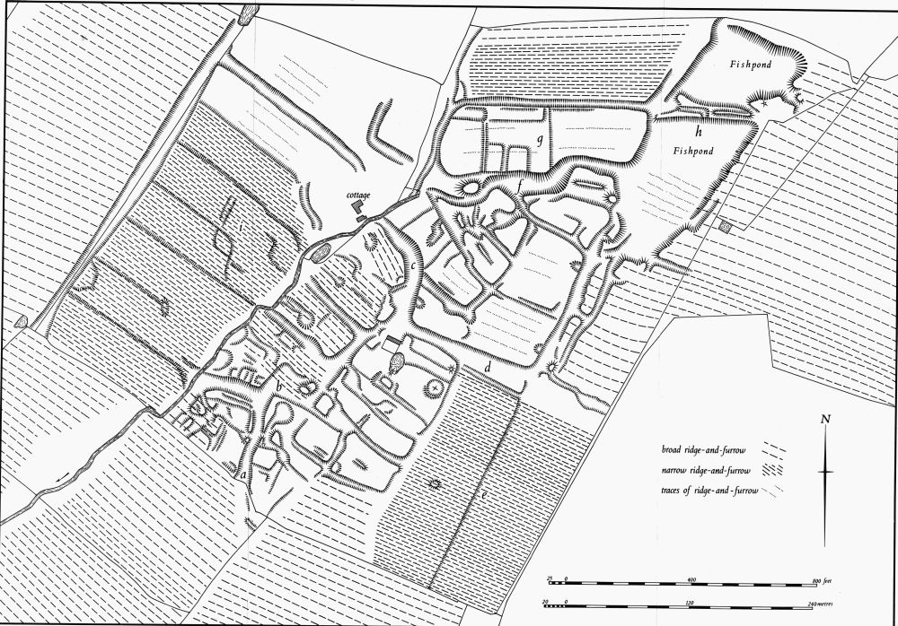
Fig. 22 Barby (1) Deserted village of Onley
The remains of the village cover some 28 hectares and are well preserved. Some difficulty in interpretation results from the fact that most of the site has been over-ploughed in narrow ridge-and-furrow which has smoothed and flattened the village earthworks. This fact alone would make the site of unusual interest, and a number of other features combine to make it one of the most important in the county despite the unfortunate lack of documentation.
The remains lie on either side of a small S.W.–flowing stream, the N.E. part of which is now in a culvert and visible only in wet weather. The site can be divided into four parts the best preserved of which is on the S. and consists of a series of rectangular scarped closes lying on each side of a hollow-way or main street. The latter ('a'–'b'–'c' on plan) is of irregular form and, in one place ('b'), is almost totally obliterated by later narrow-rig which lies over it. At the N. end it curves N.W. to meet the stream. From this hollow-way another runs E. ('d') and a third runs W. (from 'b') to the stream. Further N. two short hollow-ways or lanes also extend N.W. of the stream. On the N.W. side of the main hollow-way are at least six long embanked closes, presumably former crofts and tofts, but all are over-ploughed by later ridge-and-furrow and any house-sites that may have existed have been destroyed. To the S.E. of the hollow-way is a further series of long closes. These do not appear to have been ploughed but no definite building platforms are visible. Further S.E. narrow-rig covers the area, but traces of a long low scarp there ('e' on plan) suggest that there may have been closes.
To the N. of one of the lesser hollow-ways ('d' on plan) and N.E. of the end of the main one ('c') is another series of closes, most of which have faint traces of later ploughing within them, but which form no coherent plan. These closes are bounded on the N. by a hollow-way ('f' on plan) which is the largest feature of the whole site, being as much as 2.5 m. deep in places. Though the hollow-way has certainly been used as a street it is in fact also the line of the original stream and must have been used as a watercourse when the village was occupied, as the water from the fishponds to the E. must have run along it.
Immediately N. of this hollow-way is a long rectangular area ('g' on plan) bounded on the N. by a narrow ditch beyond which is an area of narrow-rig ploughing. This area has been completely ploughed over at some time, but slight banks and scarps indicate that it was formerly divided into closes of various sizes. To the W. are two Fishponds of irregular shape ('h' on plan), separated by a mutilated bank or dam only 1 m. high at the W. but 2 m. high at the E. The ponds are cut into the adjacent ground and the scarps along their E. sides are up to 2 m. high. The southernmost has traces of later ploughing within it and the adjacent medieval ridge-and-furrow to the E. appears to overlie its E. edge.
On the N.W. of the stream ('i' on plan) is a large area of land covered with narrow-rig ploughing and bounded on the N.W. by a broad ditch or hollow-way, beyond which is normal medieval ridge-and-furrow. Within this area, and almost totally destroyed by the later ploughing, are traces of long narrow closes edged by low scarps. These closes appear to be more regular than those elsewhere on the site and might be regarded as a late addition to the village. On the other hand the subsequent ploughing may have altered their original form and made them look more regular than they were.
The ruinous cottage N.W. of the stream though mainly of 19th-century date contains some late 18th-century features and may be a rebuilding of one of the shepherds' cottages recorded in the early 18th century. A few sherds of 14th-century pottery have been found along the bed of the stream (CUAP, SB2–4, NT32, 33, AWQ45, 48).
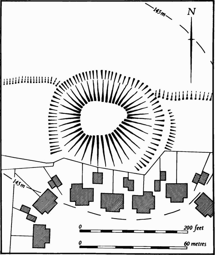
Fig. 23 Barby (2) Site of manor house
a(2) Site of Manor House (SP 543707; Fig. 23), known as Barby Castle, lies on a prominent rounded hill of clay at 145 m. above OD, dominating the village centre. It is presumably the site of an early manor house which had some form of defence. The field in which it stands was known as Hall Close in the early 19th century (G. Baker, Hist. of Northants., I (1822–30), 264).
The site consists of an oval flat-topped mound only 1 m.–1.5 m. above the surrounding hillside, bounded by a broad flat-bottomed ditch 1 m. deep. There are slight traces of an outer bank on the S.E. side but modern housing development has encroached upon the ditch on the S. and has destroyed a section of this outer bank which is visible on air photographs. From the E. and W. sides of the site broad scarps up to 1 m. high extend in both directions. These are the boundaries of old enclosures, some still with traces of ridge-and-furrow within them. To the S. of the site, in an area now covered by modern housing, air photographs show a hollow-way which presumably once linked the manor house to the village (see (3); RAF VAP CPE/UK/1994, 1353–4, 1482–3; CUAP, ACA74, 75).
a(3) Settlement Remains (centred SP 543705), formerly part of Barby village, lay immediately S. of the site of the manor house (2) and N. of Ware Road. The area has been completely built over, but air photographs taken before destruction (RAF VAP CPE/UK/1994, 1482–3; CUAP, ACA75) show a number of rectangular embanked closes along Ware Road, with a hollow-way between them linking the road with the manor house site. A quantity of medieval pottery, mainly of the 13th century, has been found in the garden of a house (local inf.). The area was already devoid of building by 1779 (NRO, Enclosure Map). These remains, together with the Enclosure Map, go a long way towards explaining the morphology of the village of Barby. The present plan suggests that it originated as one of the so-called 'double-looped' villages. However, as the map clearly shows, the village was formerly arranged around a very large rectangular green with a fortified manor house (2) on the N. and the church in the S.E. corner. From the E. side of the green three lanes extended E. to meet a back lane. The green had already been partly encroached upon before 1779, but at Enclosure the remainder was divided into small fields some of which were later built over.
Elsewhere in the village various closes bounded by low banks and scarps still remain. These appear to be former paddocks now incorporated into the adjacent fields (e.g. in the N.E. corner of the village at SP 547706 and 546704). More existed S. of the church (at SP 544701) but these have also been destroyed by modern housing (RAF VAP CPE/UK/1994, 1482–3).
(4) Cultivation Remains. The common fields of the village of Barby were enclosed by an Act of Parliament of 1778 (NRO. Enclosure Map, 1779). Immediately before that date there were three large open fields surrounding the village, Wood Field to the W., Brackleydale Field to the E., and Nether Field to the N. There was a small area of old enclosures lying W. of the village at the N. end of Wood Field (centred SP 533705) with an outlying farmstead, now destroyed, at its S. end.
Ridge-and-furrow of these common fields exists on the ground or can be traced on air photographs over almost the entire area. It is arranged in end-on and interlocked furlongs, many of reversed-S form, except in the S.E. of the parish where, on the steep slopes of Barby Hill, it radiates outwards around the spur. No ridge-and-furrow is visible in the area of the old enclosures W. of the village.
The date of the enclosure of the common fields of Onley is unknown. Ridge-and-furrow of these fields exists on the ground or can be traced on air photographs around the site of the deserted village (1) and in the N. and W. parts of the land attributable to the latter. It is arranged mainly in interlocked furlongs and is still exceptionally well preserved over wide areas. The site of the village of Onley is largely covered by narrow ridge-and-furrow (Fig. 22 and Plate 9) probably of late 18th or early 19th-century date (RAF VAP CPE/UK/1994, 1352–5, 1481–6; 106 G/UK/636, 4433–40).