A History of the County of Sussex: Volume 6 Part 1, Bramber Rape (Southern Part). Originally published by Victoria County History, London, 1980.
This free content was digitised by double rekeying. All rights reserved.
A P Baggs, C R J Currie, C R Elrington, S M Keeling, A M Rowland, 'Bramber', in A History of the County of Sussex: Volume 6 Part 1, Bramber Rape (Southern Part), ed. T P Hudson (London, 1980), British History Online https://www.british-history.ac.uk/vch/sussex/vol6/pt1/pp200-214 [accessed 30 April 2025].
A P Baggs, C R J Currie, C R Elrington, S M Keeling, A M Rowland, 'Bramber', in A History of the County of Sussex: Volume 6 Part 1, Bramber Rape (Southern Part). Edited by T P Hudson (London, 1980), British History Online, accessed April 30, 2025, https://www.british-history.ac.uk/vch/sussex/vol6/pt1/pp200-214.
A P Baggs, C R J Currie, C R Elrington, S M Keeling, A M Rowland. "Bramber". A History of the County of Sussex: Volume 6 Part 1, Bramber Rape (Southern Part). Ed. T P Hudson (London, 1980), British History Online. Web. 30 April 2025. https://www.british-history.ac.uk/vch/sussex/vol6/pt1/pp200-214.
In this section
BRAMBER
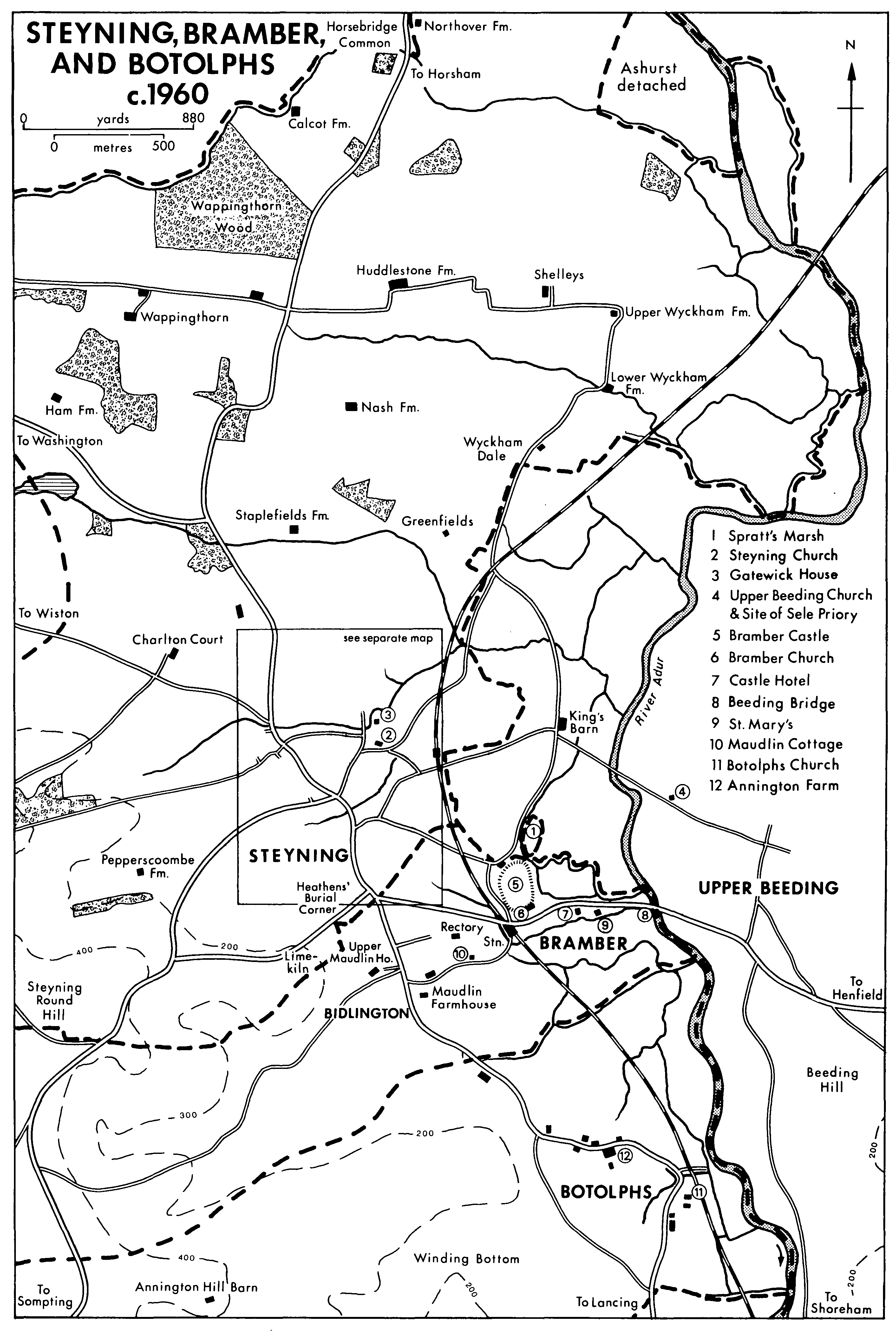
Steyning, Bramber, And Botolphs c.1960
The former borough of Bramber, (fn. 1) with its castle, once the centre of civil administration in the eponymous rape, lies 4 miles from the sea, on the west bank of the Adur at the point where that river begins to break through the South Downs. The ancient parish comprised 851 a.; in 1933 Botolphs civil parish was added to it, (fn. 2) the modern parish in 1971 having 1,771 a. (717 ha.). (fn. 3) The two parishes had, however, been united for ecclesiastical purposes since 1526. The present article deals only with the ancient parish, except for the sections concerning church history after 1526 and education, in which the histories of Bramber and Botolphs are intertwined.
The ancient parish was elongated in shape from west to east. The western part lay on chalk, rising to c. 500 ft., and the eastern part on alluvial deposits along the river. (fn. 4) Bramber castle occupies what appears to be an ancient meander core of chalk c. 90 ft. high, (fn. 5) and the village of Bramber is partly built south-east of the castle on a man-made causeway leading from the higher ground on the west towards the river. Much of the eastern part of the parish was formerly tidal marsh, where salt was being extracted in the late 11th century (fn. 6) and probably much earlier. As early as 956 there seem to have been two main channels, a deep eastern one, possibly resembling the modern course of the river, and a western one called the Bramber. (fn. 7) Some of the salterns evidently occupied islands between the various channels. (fn. 8) Inning of the marshes had begun by the mid 13th century, the reclaimed land being protected by sea walls. (fn. 9) With the further inning of land in the Adur valley in succeeding centuries and the silting of the river seasonal flooding became frequent, and despite the embanking of the river after 1807 (fn. 10) remained so well into the 20th century. (fn. 11) Improvement of the river banks and of drainage in the late 1950s made possible the conversion of brookland pasture to arable. (fn. 12) The eastern boundary of the ancient parish was formed by the modern channel of the river Adur, and part of the northern boundary by what is apparently the stream called the Bramber in 956. (fn. 13) The southern boundary formed part of the boundary of the Saxon estate of Bidlington in 956, (fn. 14) and the northern and western boundaries may have done so too. Bramber, however, did not become a separate parish until after 1100.
The original settlement in the parish was at Bidlington, on the rising ground just above the Adur flood plain. Bidlington occurred as a vill c. 1260, (fn. 15) and a tithing called Bidlington and Southbrook (the latter place being in Steyning parish) was mentioned as late as 1670. (fn. 16) An alternative name was Maudlin, (fn. 17) after the medieval hospital of St. Mary Magdalen that stood there. (fn. 18) By 1729 (fn. 19) the hamlet had contracted to at most 6 houses, including those belonging to the three chief estates of the parish. (fn. 20) Magdalen Farm Cottage to the east is 17th-century with later additions. A network of footpaths recorded in 1875 perhaps represented former streets in the hamlet. (fn. 21)
The name Bramber is generally considered to mean a bramble thicket, (fn. 22) being transferred first (before 956) to the river estuary and then, at its building, to the Norman castle. (fn. 23) There is no evidence of pre-Conquest settlement on the site of the present village. After the Norman Conquest the lordship later called the rape of Bramber was granted to William de Braose, who had built a castle at Bramber by 1073. Like many other Norman castle-builders, (fn. 24) he also founded a borough under its walls, which was deliberately intended as a rival to Fécamp abbey's borough of Steyning. The original nucleus of the borough presumably lay on the dry land on the edge of the marsh, but it afterwards expanded on to the causeway which de Braose constructed as a new crossing of the Adur estuary. (fn. 25) Burgages were referred to in a grant which de Braose made, apparently before 1087, to Battle abbey; the description of them as lying 'in the land of the saltern' suggests that they may have occupied ground won from the marsh. (fn. 26) The borough apparently already existed by 1086, for de Braose's encroachments on Fécamp abbey's land and rights mentioned in a decree of that year seem likely to be connected with the laying out of it. (fn. 27) It may even have existed in 1073, if tolls then being taken at the castle were market tolls. (fn. 28) By the 1086 decree de Braose was ordered to undo some of what he had done, (fn. 29) and the presumed setback to the new borough may have precipitated the foundation of New Shoreham instead.
Bramber borough never seems to have been prosperous. In 1334 it was the poorest borough in the county, taxed at less than half the rate of the next poorest. (fn. 30) Seven years later it was said to have declined greatly since 1291, and to be completely impoverished, with no merchants or tradesmen of any substance. (fn. 31) In the 15th century many burgages were empty or ruined, (fn. 32) and the borough was again lowly assessed in 1524. (fn. 33) Returns to early-17thcentury subsidies were a fraction of those of Steyning, (fn. 34) and in 1705 only two parishioners had the county franchise, one being the innkeeper. (fn. 35) A visitor in 1713 found 'scarce a house . . . fit for a stable', (fn. 36) and Defoe a few years later noted that not many of the inhabitants were above asking alms from travellers. (fn. 37) After the mid 19th century, however, Bramber acquired a new purpose as a place of residence and a focus for tourism.
Many urban properties belonging to Sele priory are recorded in Bramber in the 13th century. (fn. 38) It seems probable that all lay west of the site later occupied by the house called St. Mary's (about half-way between the castle and the modern channel of the Adur). The fact that new tenants of the priory further east were being encouraged at the same date to add to their holdings by reclamation suggests that that part of the causeway was not then built on. (fn. 39) The policy was presumably unsuccessful, for relatively little land was reclaimed for building on either side of the part of the causeway east of St. Mary's by comparison with that to the west. (fn. 40) In the mid 19th century there was only one building on the causeway east of St. Mary's. (fn. 41) Some burgages lay west of the castle along the old road to Steyning; a burgage there was mentioned in the 15th century, (fn. 42) and there were two houses there in the 18th century which were later destroyed for the railway. (fn. 43) In 1730 many old foundations could be seen in that area. (fn. 44) A number of other burgages of Bramber borough lay physically in Steyning, in the eastern angle of Church Street and High Street; as late as the 19th century they belonged to Bramber for electoral if no longer for local government purposes. (fn. 45) They seem to be identical with the eighteen houses which the de Braose family claimed in Steyning in the late 11th century, (fn. 46) being perhaps originally tenements of King's Barns manor (in Beeding), which extended into Steyning town. (fn. 47) By a decree of 1103 the de Braoses were to hold the tenements of Steyning borough, (fn. 48) though there is no reference to their having been so held after 1229; (fn. 49) being urban, they presumably came to be associated with Bramber borough rather than with the rural manor to which they may have belonged.
In 1811 there were only 25 houses in the parish. (fn. 50) During the late 19th and early 20th centuries many of those in the village were rebuilt, and new ones were built on the vacant plots between them. Other houses were built at the same time in Castle Lane and around the former Bidlington hamlet. (fn. 51) The rate of building new houses increased after the Second World War, especially at Bidlington, where a number of private estates were laid out in the 1950s and 1960s, many old trees being preserved. At the same time houses were built on the previously unoccupied section of the causeway east of St. Mary's. (fn. 52) Despite the increase in building, however, Bramber still remained physically distinct from Steyning in 1976.
Most of the buildings of the village are of the 19th and 20th centuries. Some of the earlier buildings have squared flints or ashlar masonry presumably taken from the castle or the bridge. St. Mary's Lodge is a refronted timber-framed building apparently of the 17th century. Two other buildings are 15th-century. The Old Priory, formerly Priory Cottage, (fn. 53) comprises a two-bay aisled hall of fine workmanship with a solar wing to the east. The building is mostly faced with flint and brick, but some timber-framing is visible in the east wall. St. Mary's opposite (fn. 54) is one range of a timber-framed lodging or inn which is jettied on the north and east. There were probably other ranges along the street and to the west. The first floor formerly had five chambers which were reached by an external gallery on the west and the ground floor had one large room to the south and three smaller ones to the north. The building is said also to have been the house of the warden of the bridge, an office recorded c. 1225, (fn. 55) and if so may be contemporary with the rebuilding of the bridge (see below). It was apparently called Chapel House in the 16th century; (fn. 56) the present name, though modern, similarly alludes to the dedication of the bridge chapel. In the late 16th century the south wall was rebuilt in stone, which was continued round part of the gallery. At about the same time the ground floor was rearranged, a chimneystack being inserted, and an attic floor was put into the formerly open roof. Those changes may have coincided with the separation of the surviving building from the ranges to the west. In the late 17th century one of the first-floor rooms was panelled, and the staircase is of similar date. St. Mary's was much restored in the late 19th and 20th centuries, (fn. 57) various fittings being imported and large additions being made on the west.
Two old routes crossed at Bidlington. One, already a hollow-way in 1689, (fn. 58) led from Steyning to Coombes, Lancing and Shoreham, and the other led from the downs by the west side of the castle mound to King's Barn (in Beeding) and what was presumably an early crossing of the estuary between King's Barn and Beeding church. There was apparently another early crossing of the estuary at Botolphs, south of Bramber, but there is no evidence for a pre-Conquest crossing at Bramber itself. In 1086 William de Braose was said to be charging tolls from traffic going to Steyning at his 'bridge' at Bramber. Since no tolls had been paid before the Conquest (fn. 59) it seems clear that William had built the bridge himself. In later times there were two bridges at Bramber, Beeding bridge on the east over the deeper channel of the estuary, and Bramber bridge further west, near St. Mary's. (fn. 60) It has been suggested that the bridge mentioned in 1086 was the former, and that the latter was not built until a century or more afterwards. (fn. 61) Since, however, de Braose's bridge was said to be impeding shipping bound for Steyning in 1103, (fn. 62) it seems likely that it crossed both channels. An alternative explanation is that the word usually translated as 'bridge' (pons) here means a causeway. (fn. 63) The entire village street east of the south-east corner of the castle mound, where the chalk yields to alluvium, (fn. 64) is carried on a causeway. The part extending to Bramber bridge incorporates timber piles which may date from the late 11th century, (fn. 65) and which perhaps continue further east.
Custody of the causeway was granted by William de Braose or his grandson and namesake to Sele priory, together with lands and other revenues and timber for its repair, and the grant was confirmed to the priory by his descendants at various times. (fn. 66) In the late 12th century it was still referred to as the whole causeway (totum pontem), (fn. 67) but by c. 1230 the parts which crossed the two channels had come to be considered as two separate bridges, a greater one on the west and a lesser one on the east. (fn. 68) Perhaps already by that date, and certainly by the mid 13th century, (fn. 69) the greater bridge was of stone. The lesser bridge was of wood. (fn. 70) As rebuilt after 1477 Bramber bridge was 170 to 200 feet long, with four depressed arches, the central pier projecting on the south side to carry a chapel dedicated to St. Mary. (fn. 71) Repairs to the chapel were mentioned in 1304, (fn. 72) and it was probably contemporary with the original stone bridge. There is an inventory of its contents dated 1412, but by 1437 services were apparently no longer regularly held. (fn. 73) It has usually been assumed from the size and strength of the late-15th-century bridge that the channel it crossed was the main channel of the river, (fn. 74) but there is no proof of that, and the channel may simply have been a wide and shallow one; the cost of building in stone would be at least partly defrayed by offerings collected at the bridge chapel.
The road through Bramber formed part of the great medieval east-west route through Sussex, which led from Southampton to Canterbury. (fn. 75) Eleanor, countess of Leicester, used it in 1265 (fn. 76) in going from Portchester (Hants) to Dover, and Edward I passed through Bramber many times. (fn. 77) In 1282 when one or other bridge was impassable the monks were allowed the use of a ferry. (fn. 78) Under the mismanagement of the priory in the mid 15th century the bridge and chapel fell into ruin. (fn. 79) They were repaired from 1477 onwards at the expense of William Waynflete, bishop of Winchester, using some of the old materials. (fn. 80) Later, however, and apparently by 1627, (fn. 81) the western channel was reduced by the inning of the marshes and the silting of the estuary to a tiny stream, and the great stone bridge was buried. The modern road lies a little way to the north; (fn. 82) the corresponding bridge belonged to the Commissioners of Sewers for Bramber rape c. 1840, (fn. 83) but in 1976 the channel was virtually a culvert.
By 1570 the eastern bridge had come to be known as the 'greater'; when in that year the timbers of which it was still composed were washed away, timber was granted for its repair from St. Leonard's forest (in Lower Beeding), in accordance with the terms of William de Braose's grant of the bridge to Sele priory. (fn. 84) The bridge had passed with the rest of Sele priory's lands to Magdalen College, Oxford, which continued to own it until at least 1840. (fn. 85) The responsibility for its upkeep was usually laid on the vicar of Beeding as a condition of his lease of Beeding rectory, (fn. 86) and it was repaired at the vicar's expense in 1726. (fn. 87) It remained of timber until 1785, when Magdalen College rebuilt it in brick on account of the increase in heavy traffic over it, the vicar paying a fifth of the cost. (fn. 88) Further repairs were carried out in 1819, (fn. 89) and the bridge was widened on the north side c. 1845. In 1926 a steel openwork footbridge was built just south of it. (fn. 90) Magdalen College was also responsible in the mid 19th century for repairing part of the main road between Bramber and Beeding bridges, a reminder that bridges and causeway were originally one. (fn. 91)
Three roads link Bramber with Steyning. One, already mentioned, passes through Bidlington. (fn. 92) Castle Lane further north seems likely from its straightness to have been deliberately created, possibly by William de Braose in the late 11th century. (fn. 93) The modern road between the two places was constructed under an Act of 1764 by which the road from Horsham to Upper Beeding was made a turnpike. (fn. 94) A turnpike gate and toll-house were erected at the west end of Bramber village. (fn. 95) The road was disturnpiked in 1885. (fn. 96) A road from Steyning to Lancing and Worthing, which was used by coaches in the 18th or 19th century, (fn. 97) passes through the western part of the parish.
After three abortive projects between 1844 and 1856, (fn. 98) a railway line through the parish, with a station near the castle, was opened in 1861. (fn. 99) It closed in 1966. (fn. 100)
Thirteen inhabitants of Bramber borough and 19 of Bidlington tithing were taxed in 1327; in 1332 the corresponding figures were 14 and 15. (fn. 101) At those dates, and later too, population totals for the borough presumably included those tenants whose tenements lay in Steyning. In 1524 17 persons were assessed in the borough, and in the following year 19; the inhabitants of Bidlington were not distinguished from those of Southbrook (in Steyning), but seem to have been few. (fn. 102) In 1539 only 15 men were mustered from the borough, less than half the number from large villages like West Tarring and Washington. (fn. 103) There seems to have been an increase of population in the 17th century. At least 26 inhabitants of the borough were assessed to the hearth tax in 1664, besides c. 5 in Bidlington. (fn. 104) There were 72 adults in the parish in 1676, (fn. 105) and 24 families in 1724. (fn. 106) In 1801 the population of the parish was 91. Thereafter it fluctuated, increasing by nearly half in the decade 1831-41, then, after a fall, by the same proportion again, as a result of the building of the railway, in the decade 1861-71. From a peak of 186 in 1881, the population fell to 162 in 1901, but then increased steadily to 270 in 1931. In 1951 the combined parishes of Bramber and Botolphs had 316 inhabitants; by 1971, as a result of extensive building in the former parish of Bramber the total had risen to 700. (fn. 107)
Two inns existed in the parish in 1538, (fn. 108) presumably including the Lion mentioned in 1526. (fn. 109) That was probably identical with the White Lion recorded in 1549 (fn. 110) and later, which was renamed the Castle Hotel c. 1870; (fn. 111) a burgage tenement, (fn. 112) it presumably derived its name from the arms of the dukes of Norfolk. (fn. 113) In the absence of a town hall it served for holding borough courts and elections of members of parliament; (fn. 114) the venality of elections in the 18th century enriched at least one publican. (fn. 115) In the 19th century public meetings were held there. (fn. 116) The building was greatly enlarged in the late 19th century to accommodate the large numbers of visitors to the village; (fn. 117) part of the old inn survived in 1976 behind the florid late-19th-century front range. There was a temperance hotel in the village between 1895 and 1938, and a private hotel and a guest house were recorded in the 1930s. (fn. 118)
Despite the strategic importance of its site Bramber only rarely appears in military history. Apart from the early-13th-century events recorded elsewhere, (fn. 119) the most important occasion was in 1643, when the bridge was twice successfully defended by parliamentary forces, thus protecting the eastern part of the county from royalist invasion. (fn. 120) In 1651 the future Charles II successfully evaded the garrison when passing through the village in his flight to France. (fn. 121)
Walter Potter, son of an owner of the White Lion, and an amateur taxidermist, opened a display of his work at the inn in 1861, which later moved to a permanent museum building near by. The collection was very popular with visitors; after being sold c. 1972 it was being exhibited in Arundel in 1976. A museum of smoking was opened in the museum building in 1973. (fn. 122)
CASTLE
The defensive and strategic advantages of the high natural mound commanding the Adur estuary on which Bramber castle stands may well have been appreciated in early times, but there is no archaeological evidence for pre-Norman occupation. A castle was built by William de Braose soon after his acquisition of the rape of Bramber, and certainly by 1073, (fn. 123) the site being a detached part of his demesne manor of Washington. (fn. 124) At the same time or shortly after he also laid out a park and a warren which, as they were on land belonging to Fécamp abbey, were ordered to be destroyed in 1086. (fn. 125) The castle thereafter descended with the rape. In the late 11th century it seems to have been alternatively known as Steyning castle. (fn. 126)
From the beginning it served as the centre of administration in the rape, the honor court being usually held there. (fn. 127) In Stephen's reign there may also have been a mint. (fn. 128) In the early 13th century the castle played a part in the civil war between King John and the barons. During the forfeiture of the rape between 1208 and 1215, and also for a time afterwards, the castle was in the keeping of a succession of royal henchmen, including Roland Bloet (recorded 1210, 1214-15), (fn. 129) John of Monmouth (1215), (fn. 130) and Robert le Savage (1217). (fn. 131) King John visited Bramber in 1209, (fn. 132) and in the following year the castle was extensively repaired. (fn. 133) There were further repairs in 1214, (fn. 134) and after the surrender of London to the barons in the following year Bramber became a base for the royal forces. (fn. 135) The king may have visited Bramber again in 1216. (fn. 136) In the following year the castle was for a time in the hands of Louis VIII of France, being held for him by William of Duston. (fn. 137) In 1234 it was again in royal hands when Peter de Rivaux and Robert le Savage successively had the keeping, and when it was alerted against the threat of a French invasion. (fn. 138) Both murage and castle-guard services were exacted from tenants of the rape. Most commuted both services in 1267 and 1268, (fn. 139) though an estate in Edburton still owed them two years later. (fn. 140) In 1275 some tenants complained that William de Braose was exacting escort service. (fn. 141)
Edward I visited the castle several times between 1280 and 1305. (fn. 142) Once the castle had passed to the Mowbray family, however, it apparently ceased to be regularly inhabited. In 1338 John Mowbray was ordered to go there to repel a possible French invasion. (fn. 143) Fifty years later the castle was no longer even properly fortified, and the men of the county complained to the king that the surrounding country was virtually defenceless. (fn. 144) The castle retained its administrative role, however; the honor court presumably continued to be held there, and inquisitions were taken at Bramber, presumably in the castle, in the 14th century. (fn. 145) In 1417 John, duke of Bedford, then regent, witnessed a deed at Bramber. (fn. 146) Fourteenth- and early-15th-century keepers of the castle included John of Derby (recorded between 1362 and 1371) (fn. 147) and Sir John Dalingridge (noted 1405). (fn. 148)
The day-to-day management of the castle in the Middle Ages was in the hands of a constable, first recorded in 1210. (fn. 149) A number of 13th-century constables are known by name. (fn. 150) The last reference found to a holder of the office is of 1456. (fn. 151) A keeper of the castle gate was mentioned in 1291; (fn. 152) in 1369 he received 30s. a year. (fn. 153) A prison at the castle was recorded between 1217 and 1355. Apart from a horse-thief in 1288 and two pirates in 1355, the prisoners mentioned were mostly murder suspects, held briefly at Bramber before being taken to the county gaol at Guildford. (fn. 154)
Ceramic evidence indicates that the castle ceased to be used in the mid or late 15th century. (fn. 155) In 1553 it was described as the 'late castle'; the site was then being used for grazing (fn. 156) as it continued to be until the mid 19th century. (fn. 157) In the mid 17th century it was briefly converted into a rabbit warren. (fn. 158) Like the lands lying immediately to east and west, the castle grounds were considered during that period as part of the demesne lands of King's Barns manor in Beeding. (fn. 159) The military importance of the site was recognized on two occasions: in 1643 the castle was briefly occupied by royalist troops, (fn. 160) and in 1778-9 it was proposed to use it for defence against a possible French invasion. (fn. 161) In 1798 the castle mound was visited for the wide views obtainable from it, (fn. 162) and by 1854 it was being used for picnics. (fn. 163) During the late 19th and early 20th centuries it was usually let to the landlord of the Castle Hotel, who made a profit from entrance fees and the supply of refreshments. (fn. 164) The castle was sold by the duke of Norfolk c. 1925; after passing through various hands, and being used as tea gardens and an occasional fairground, it was bought by the National Trust in 1945. (fn. 165)
The first castle (fn. 166) consisted of a motte with a penannular ditch. The motte later partly collapsed or was pushed into the ditch, which was invisible in 1976. Before the end of the 11th century a curtain wall had been constructed round the mound, together with an outer ditch or moat, which was too high ever to have been filled with water, except perhaps in its east part. The east side of the mound was scarped back in creating the ditch, leaving the motte off-centre. Also before 1100 a stone and flint gatehouse was built at the south side; its relation to the curtain-wall is not clear. Not long after, and perhaps also before 1100, the gatehouse was converted into a keep by being heightened c. 50 feet. A window in the upper part of the surviving wall seems early-12th-century in date. (fn. 167) The stone and flint bridge across the south side of the ditch apparently incorporates work from its 11th- or 12th-century predecessor.
It seems probable that an outwork on the south side of the castle mound enclosed the site of the church. A rampart excavated in 1926 at the junction of the main street of the village with Castle Lane (fn. 168) may have belonged to it. The theory that the outwork extended south of the street to give access to a quay, (fn. 169) however, seems tenuous, especially since a burgage tenement is recorded opposite the castle gate c. 1240 and later. (fn. 170)
Repairs to the walls, ditch, drawbridge, hall, and one chamber are documented in 1210, (fn. 171) and more building work was going on in 1266 or 1267, when a cut was made from the river estuary, apparently north of the village street, for bringing up materials. (fn. 172) The scale of the castle's accommodation in the mid 13th century may be gauged from the fact that in 1265 Eleanor, countess of Leicester, stayed there with a train of 84 horses. (fn. 173) There was further extensive building work in 1325 and 1326. (fn. 174) A group of flint and stone buildings in the north-east corner of the mound, excavated in the 1920s or 1930s and including a hall and kitchen, (fn. 175) perhaps represent part of it. The remains of a workshop and two lime kilns found near the motte in 1966-7 may also be of that date. There were other buildings within the castle yard too. In 1369 mention was made of the site of the castle with 'the walls, towers, and houses built thereon'. (fn. 176) In 1291 Mary de Braose, widow of William (d. 1290), received as dower a barn in the castle for storing her corn; from a reference in the agreement to the danger of fire to the other castle buildings, it seems likely that they were mostly of timber. (fn. 177) The castle was supplied by the demesne lands of King's Barns manor lying around it, which included closes called Castle field, Castle meadow and Castle brooks. (fn. 178) A fishpond east of the castle was mentioned in 1399 and 1498. (fn. 179)
At the end of the 16th century the castle was said to have largely fallen to the ground, and to be 'nothing but a heap of stones'. (fn. 180) Engravings of the mid 17th century (fn. 181) show the north, east, and west walls of the tower still standing to full height; the south wall of the tower, and also much of the curtain wall, had collapsed, presumably because of erosion of the ditch. There is no evidence for the idea that the castle was slighted during or after the Civil War. Later collapses and the robbing of the building for flint and stone had left only the west wall of the tower standing, almost to its original height, by 1760; (fn. 182) its appearance then was virtually the same as in 1976. During the late 17th century or early 18th the ruin was for a time adapted as humble dwellings.
MANORS
The BOROUGH of Bramber, often in later times called a manor, descended with the rape.
The manor of BIDLINGTON, comprising most of the parish, was mentioned in 956. Evidently it had been part of the large estate of the kings of Wessex, which also comprised Steyning, Annington (in Botolphs), and Beeding. (fn. 183) William de Braose held it in 1073. (fn. 184) It was not mentioned separately in Domesday Book, but was evidently at that time part of the estate which he was described as holding in Steyning, and which also apparently included King's Barns manor in Beeding. (fn. 185) In the early 13th century that estate was apparently called Steyning Braose. (fn. 186) Bidlington seems to have been held in demesne until 1281, when William de Braose was granted or confirmed in free warren there. (fn. 187)
In the same year the reversion of the manor was settled on his younger son Richard, with remainder to Richard's younger brother Peter. (fn. 188) At William's death in 1290 his eldest son William (d. 1326) acquired the manor, (fn. 189) but he was ordered to restore it in the following year. (fn. 190) He had acquired it again by 1316, (fn. 191) but Peter's son Thomas was confirmed in it in 1317 (fn. 192) and again in 1331. (fn. 193) By a settlement of 1337 (fn. 194) Thomas (d. 1361) (fn. 195) and his wife Beatrice (d. 1383) (fn. 196) held the manor jointly; in 1361, as later, (fn. 197) it was held of Bramber honor. Their son Thomas and his infant son and daughter all died successively in 1395, and the manor apparently passed to the younger Thomas's niece Elizabeth and her husband Sir William Heron. (fn. 198) In 1412 John de Braose of Wiston held it (fn. 199) and in 1418 George Braose or Brewes died seised of it, being succeeded by his great-great-nephew (fn. 200) Sir Hugh Cokesey (d.1445), who held it jointly with his wife Alice (d. 1460) under a settlement of 1441. (fn. 201) Hugh's sister and heir (fn. 202) Joyce Beauchamp (d. 1473) was succeeded by her son (fn. 203) Sir John Greville (d. 1480), and John apparently by his son Thomas Cokesey. (fn. 204) By 1506 the manor had been resumed into the barony, since Thomas Howard, earl of Surrey and later duke of Norfolk (d. 1524), was dealing with it then. (fn. 205) He granted or devised a life interest in it to his son William, (fn. 206) created Lord Howard of Effingham, (fn. 207) and in 1553 William received the reversion from the Crown. (fn. 208) William was still lord in 1566, (fn. 209) but by 1576 the manor had again been resumed into the barony, (fn. 210) with which it descended thereafter. (fn. 211)
The demesne lands of Bidlington manor were granted in 1553 (fn. 212) to Thomas Parson (d. 1565), who settled them shortly before his death on his two sons-in-law, Edward Michelborne and Richard Farnfold. (fn. 213) The two moieties thereafter descended separately; their contemporary nomenclature is confusing, both estates being loosely called manors, and they are best described as BIDLINGTON FARM and HARROCKS respectively. Edward Michelborne died in 1587, and his son Edward (fn. 214) sold Bidlington farm in 1598 to Thomas Bishop, (fn. 215) who conveyed it in 1602 to Nicholas Backshell. (fn. 216) Richard Backshell, perhaps succeeding another Richard who died c. 1641, (fn. 217) died seised of it in 1656 or 1657, (fn. 218) and in the following year his widow sold it to John Turner. (fn. 219) John's son Samuel (fn. 220) held it in 1684, (fn. 221) but had died by 1693 when his brother Nathaniel (d. 1694) had it as executor. (fn. 222) Nathaniel's son (fn. 223) Thomas conveyed it in 1697 (fn. 224) to John Mounsher (d. 1702), (fn. 225) whose daughter Elizabeth sold it in 1728 to Thomas Lidbetter. (fn. 226) Thomas (d. 1737) was succeeded by a son (d. 1765) and grandson (d. 1816) of the same forename. (fn. 227) Richard Lidbetter, nephew of the last-named, had the estate in 1830, (fn. 228) but had died by 1873; (fn. 229) the executors of his widow Sophia who died in the same year (fn. 230) sold the estate in 1874 to Henry Padwick. (fn. 231) Another Henry Padwick held the lands in 1913, (fn. 232) but by 1922 they had passed to L. C. Ing, and by 1938 to L. G. Russell. (fn. 233)
Richard Farnfold died seised of lands in Bramber, presumably Harrocks, in 1609. (fn. 234) In 1617 the estate was settled on his daughter Jane and her husband Laurence Delachamber, who sold it in 1622 to Sir Thomas Farnfold. (fn. 235) After Sir Thomas's death in 1643 (fn. 236) his son Henry sold it to Richard Marcall in 1645, (fn. 237) but in the following year the estate was ordered to be conveyed to Sir David Watkins in satisfaction of a debt. (fn. 238) In 1653 John Vaux sold Harrocks to John Turner, whose son Nathaniel held it from 1675 until his death in 1694. Nathaniel's son Thomas (fn. 239) (d. c. 1710) (fn. 240) was succeeded by a daughter Mary, who married first Henry Worsfold and then Samuel Wilson. (fn. 241) In 1735 Samuel and Mary Wilson sold the estate to Sir John Lade (d. 1740), who was succeeded by his great-nephew, also Sir John (d. 1759), whose son Sir John (fn. 242) sold it to Thomas Lidbetter in 1782. (fn. 243) Thereafter Harrocks descended with Bidlington farm. The quit-rents payable from both Bidlington farm and Harrocks to the duke of Norfolk as lord of Bidlington manor were redeemed in 1874. (fn. 244)
Bidlington Farmhouse or Upper Maudlin Farmhouse (fn. 245) was rebuilt in the early 19th century as a two-storeyed stuccoed building, which survived in 1976 as Maudlin House.
The lands of Sele priory in Bramber parish (fn. 246) passed to Magdalen College, Oxford, which had them in 1535. (fn. 247) In 1729 they were estimated at 66½ a. (fn. 248) and c. 1840, after some land had been exchanged, (fn. 249) at 46 a. (fn. 250) During the 18th and 19th centuries they were let at 20-year leases, renewable every seven years. (fn. 251) They were sold by the college in 1883. (fn. 252) The manor-house of the college estate called Maudlin Farmhouse is of the 17th century or earlier with later additions. The lands of the Braose foundation of Bidlington hospital, (fn. 253) of which half a yardland and 3 roods were mentioned c. 1240 (fn. 254) and 7 a. in 1272, (fn. 255) had apparently been resumed by 1553 into Bidlington manor. (fn. 256) Their location is unknown, but the hospital apparently stood near Maudlin House, in the north-west angle of Bidlington cross-roads. (fn. 257)
ECONOMIC HISTORY
Agriculture
In 1086 the land within what later became Bramber parish evidently formed part of the estate of William de Braose which was described as lying in Steyning. (fn. 258) When that estate was divided into the manors of Bidlington and King's Barns, most of the land in the parish joined Bidlington, though some land around the castle formed part of the demesne lands of King's Barns. (fn. 259) Flax and hemp may have been grown in the parish in the late 11th century, (fn. 260) and barley, vetch, (fn. 261) apples, hemp, and honey were mentioned in the early 14th century. Arable farming still dominated at the latter date, the ninth of sheaves in 1341 yielding eleven times as much as that of fleeces and lambs. (fn. 262) The pattern of land-use in the parish at that time was probably the same as later, the arable land surrounding the hamlet of Bidlington, flanked to east and west respectively by brookland pasture and downland pasture, as the underlying geology indicated. Field names recorded in the Middle Ages are Westmostfurlong and Howclinch, (fn. 263) which cannot be certainly located, and the Hurst, including furlongs called Borfurlong and Wogefurlong, which lay south-east of Bidlington hamlet. (fn. 264) A meadow called the Vuur in the mid 13th century may have been common meadow. (fn. 265) Three common marshes, Northmarsh, Southmarsh, and Sudwisse, were mentioned c. 1260, when Sele priory and other tenants exchanged common rights in the last-named for rights in the other two. (fn. 266)
There were perhaps 30 burgages in Bramber in the Middle Ages, (fn. 267) and in the 18th century about the same number. (fn. 268) One at least was not enfranchised until 1874. (fn. 269) Both free and copyhold tenants of Bidlington manor are recorded in the 16th and 17th centuries, including some in West Grinstead and Cowfold. Both kinds of tenants paid heriots in the 16th century at least; in the late 17th century reliefs or entry fines were payable. The custom of widow's freebench obtained in 1547. (fn. 270) Tenements were few in number and mostly small in area; by far the largest estates in the parish were the two moieties of the demesne lands, Bidlington farm and Harrocks, (fn. 271) each estimated at 114 a. in 1729. (fn. 272) Wheat, barley, oats, peas, and tares were grown in the parish in the 17th and 18th centuries, when sheep-farming was also becoming important, flocks of up to 460 animals being mentioned. (fn. 273) The descendants of John Lidbetter, under-tenant of Bidlington farm in 1635, (fn. 274) gradually came during the next hundred years to be the chief occupiers of land in the parish. John Lidbetter (d. 1709) (fn. 275) bought small estates in the parish in the late 17th and early 18th centuries, (fn. 276) and had the lease of Harrocks in 1709. (fn. 277) His son Thomas (fn. 278) bought Bidlington farm in 1728, (fn. 279) and in the following year was owner or occupier of most of the parish, including Harrocks and the Magdalen College estate. (fn. 280)
At that date most of the arable land of the parish lay in two large open fields on either side of the road from Bidlington hamlet to Botolphs. The 21 furlongs of which they were composed included East, Middle, Street, Dyke, Magdalen, Red Beach and Winchester Dean furlongs, (fn. 281) some of which had been mentioned in 1689. (fn. 282) Most of the arable land north-east and north-west of Bidlington had been inclosed, and only one open field furlong, called Hutticks, survived. Some inclosure had already taken place there by the mid 16th century, when closes were recorded with names like Maudlin field and West field, which might suggest former open fields. (fn. 283) Chapel furlong, recorded in 1689, (fn. 284) perhaps lay in that area too. In 1729 the two surviving open fields were divided between at least 9 separate estates, most strips being less than 1 a. in area.
Most of the brookland pasture of the parish was by that date in several ownership, only 10 a. of common brook surviving. A number of estates had had common rights in the marsh in the 17th century, for instance Bidlington farm four bullock leazes and Harrocks six. (fn. 285) There had always been much several marshland in the parish, however, many parcels being former salterns. (fn. 286) There were 277 a. of common downland pasture in 1729, and 148 a. of several down belonging to Bidlington farm. Common rights on the downs had also been recorded in the 17th century; for instance, Bidlington farm had had 400 sheep leazes and Harrocks 500. Bidlington farm had also had several downland in 1602. (fn. 287)
Between 1729 and 1874 successive members of the Lidbetter family gradually bought up most of the smaller estates in the parish, (fn. 288) while continuing to hold the lease of the Magdalen College estate. (fn. 289) By 1840 Richard Lidbetter occupied more than nine-tenths of the parish, most of the land being his own. By that date the former open fields had been rationalized as six large furlongs totalling c. 150 a., of which Lidbetter owned two-thirds and three others the rest. The land was still nominally divided into small strips, but since Lidbetter occupied it all the divisions were not kept. Magdalen College was by then the only commoner on both the common marsh and common downs, having six bullock leazes and 120 sheep leazes; (fn. 290) the date of extinction of those rights is unknown.
At the beginning of the 19th century there had been over 1,000 sheep in the parish. (fn. 291) In 1838 there was nearly twice as much meadow and pasture as arable, (fn. 292) but already by 1874 c. 160 a. of former downland had been converted to arable. (fn. 293) Crops mentioned in the 19th century but not before include rape, turnips, and beans. (fn. 294) After the mid 19th century the agriculture of the parish was greatly affected by the growth of the coastal towns. A market-gardener was recorded between 1855 and 1874, and a dairyman in 1895. (fn. 295) By the early 20th century the parish was largely divided between two farms, Lower Maudlin farm comprising the south-eastern part of the parish, and Upper Maudlin farm all the land west of the road from Steyning to Botolphs. In 1913, when the same farmer occupied both farms, they comprised 127 a. and 585 a. respectively, Lower Maudlin farm being described as especially suitable for dairying because of its rich brookland pasture and nearness to Brighton and Worthing. (fn. 296) An egg merchant was recorded in 1938, (fn. 297) and in 1944 Upper Maudlin farm combined cereal-growing, stock-raising, and dairying. (fn. 298) After the Second World War dairy farming greatly declined in favour of stock-raising, the riverside pasture being converted to arable. The area of the ancient parish had been split up into smaller farms during the 1930s; in 1976 there were several farms there. (fn. 299)
Mills
The mill on the Braose estate described as lying in Steyning in 1086 may have been at Bidlington. (fn. 300) A mill belonging to the castle was mentioned in 1326, (fn. 301) and a mill of Bidlington manor in 1339. (fn. 302) In the 16th and 17th centuries there was a windmill on the river bank north-west of Beeding bridge, evidently on the close called Mill Green c. 1840. (fn. 303)
Port and river traffic
The construction of Bramber castle required a wharf for landing building materials. The likely site seems to be south-west of the point where the causeway crossed the western channel of the river, near the site later occupied by the house called St. Mary's. (fn. 304) With the foundation of the borough a small port grew up, apparently recorded in William I's reign. (fn. 305) By 1181 (fn. 306) Bramber was serving as an entrepôt for Wealden timber. In the mid 13th century the port seems to have been busy, timber, oak-bark, and faggots being loaded there. (fn. 307) In 1322 it was among the Sussex ports ordered to supply the royal army in the north. (fn. 308) Bramber was still accessible to ships in the late 14th century, (fn. 309) but no later references to the port have been found, and it evidently shared the general decline of the town. The river, however, continued to provide employment. Two bargemen were recorded in the parish in 1672 and 1705. (fn. 310) In the early 19th century three barges at least plied between Bramber and Shoreham, (fn. 311) apparently from a wharf on the north side of Beeding bridge. (fn. 312) Its site may be the same as that occupied by the coal merchant and boat proprietor mentioned in 1895. (fn. 313) A barge builder was mentioned in the parish in 1845. (fn. 314)
Market and fairs
William de Braose set up a market at Bramber as part of his new borough. The first certain reference to it is before 1087, (fn. 315) but it already existed in 1073, if the tolls at Bramber granted to Bramber college in that year were, as they seem to have been, market tolls. (fn. 316) No more is heard of the market for two centuries; during that time it was presumably overshadowed by the markets at Steyning and New Shoreham. A fair existed in 1288. (fn. 317) In 1316 William de Braose was granted a Monday and a Thursday market at Bramber and two three-day fairs on the eve, feast day, and morrow of St. Denis (9 October) and of St. Augustine (presumably 26 May). (fn. 318) The grant was confirmed in 1324 (fn. 319) and 1332, (fn. 320) but in the first confirmation the feasts named were those of St. John before the Latin Gate (6 May) and St. Edward the Confessor (probably 13 October). In 1383 Thomas Mowbray, earl of Nottingham, was confirmed in the Thursday market only and in a three-day fair at the feast of the Assumption (15 August). (fn. 321) Again, the market seems not to have thrived; many shops and stalls there were described as empty or ruined between the late 14th and late 15th centuries, and the three surviving borough account rolls for the same period record no income from tolls. (fn. 322) The market had lapsed by 1595. (fn. 323) Profits of the fair were, however, being received in the 15th century: 10d. in 1445 and 12d. in 1498. (fn. 324) A fair was also being held at Bidlington during the same period, on St. Mary Magdalen's day (22 July); the profits amounted to 3s. 4d. in 1399 and 2s. 4d. in 1498. (fn. 325) Bramber market-place seems to have lain just south-west of the castle, at the junction of the village street with the two old roads from Steyning. A 'great square' (magna placea) was described as forming part of the road between Bramber and Bidlington c. 1260; (fn. 326) an open space still existed at that point in 1729, (fn. 327) but was later obliterated by the construction of the railway.
Trade and industry
Tradesmen who witnessed deeds concerning Bramber property in the mid 13th century probably resided in the borough; they included three tailors, a glover, a cooper, two masons and a smith. (fn. 328) Some of them, however, and some of the later tradesmen described as of Bramber, may have occupied the tenements of the borough which lay in Steyning. Surnames recorded in the early 14th century which might indicate trades or occupations were Baker, Roper, Chapman, and Viner. (fn. 329) A merchant dealing in unspecified commodities was recorded in the early 13th century, (fn. 330) a cloth merchant, two wine merchants, and one who dealt in both cloth and wine in 1262-3, (fn. 331) and there were still two wine merchants 25 years later. (fn. 332) By 1341, however, there were no tradesmen or merchants of any substance in the town. (fn. 333) Two retailers of ale were mentioned in 1538. (fn. 334) An important medieval industry in the parish was salt-making. The five salterns which belonged to Washington manor in the late 11th century presumably lay in the detached part of the manor which included Bramber castle. The three salterns at the Braose estate described as lying in Steyning at the same period were possibly also within the future Bramber parish, (fn. 335) since members of the Braose family later granted salterns in Bramber to Durford abbey and to Lewes and Sele priories. (fn. 336) A 14th-century reference to the carriage of salt from Bramber to Leigh near Reigate (Surr.) shows that the produce went far afield. (fn. 337) The last reference found to the industry in the parish is of 1423. (fn. 338) A number of mounds comprising debris from the operation survived north of the village street in 1976, others south of the street having been destroyed in 1972. (fn. 339)
The only trade regularly recorded in Bramber in the 17th and 18th centuries was that of wheelwright. (fn. 340) Other tradesmen mentioned at different times were a locksmith, (fn. 341) a glover, a tailor, a ripier or fresh fish carrier, (fn. 342) a carpenter, a barber, (fn. 343) and a shoemaker. (fn. 344) In 1811 one in six families in employment was supported by non-agricultural occupations, and in 1831 one in seven. (fn. 345) Tradesmen recorded between the mid 19th and early 20th centuries included wheelwrights, bakers, a shoemaker, a builder, and a butcher. In 1851 most of the tradesmen belonged to the same family, the Woolgars. In the early 20th century there were a nursery business and a laundry. (fn. 346) After the mid 19th century tourism became a chief source of employment, (fn. 347) many visitors coming by direct trains from Brighton. (fn. 348) In 1893 the village was said almost to exist by the provision of tea for visitors, (fn. 349) and a later writer called it the 'tea-party paradise of its district'. (fn. 350) Besides the castle grounds, (fn. 351) there were always several tea rooms and tea gardens in the village at that period. (fn. 352) Tourism was still important in 1976, when there were two museums, two caravan parks, a café, and two restaurants in the village. After the late 19th century Bramber also became a place for residence and retirement; by 1913 the number of inhabitants described as private residents in the parish had greatly increased from thirty years before. (fn. 353) In 1976 much of the population worked outside Bramber, many of them in the coastal towns.
LOCAL GOVERNMENT
Bramber borough was separately represented at the eyre in 1248 (fn. 354) and 1262-3, though on both occasions by four men not twelve. It was also sometimes joined with Steyning: a jury drawn from both boroughs gave evidence at the 1262-3 eyre, (fn. 355) and the two places were represented as one borough at the eyre of 1288. (fn. 356) In the 14th century, similarly, Bramber was sometimes taxed separately, (fn. 357) and sometimes as one borough with Steyning. (fn. 358) Courts baron are recorded between 1497 (fn. 359) and 1687, and view of frankpledge (twiceyearly at first) between 1368 (fn. 360) and 1792. (fn. 361) There are court rolls for 1538, 1572, 1676, 1679, 1687 and 1724-86. (fn. 362) In the later period at least the courts were held at the White Lion. (fn. 363) Breaches of the assize of ale and the regulation of nuisances were still dealt with at the view in the 16th century, (fn. 364) but by 1679 at least half the tenants apparently no longer attended. (fn. 365) Apart from occasional other business, chiefly concerning roads, the annual views of the 18th century dealt only with the election of the borough officers. (fn. 366) There was a bailiff in the Middle Ages and later; (fn. 367) a constable was recorded in 1572 and 1650, (fn. 368) and a reeve in 1657. (fn. 369) In the 18th century the constable, who was also the returning officer, was chosen by the steward from two candidates put forward by the borough jury and the outgoing constable. He then chose the headborough, who in turn chose the ale-conner. (fn. 370) All three offices survived in 1822. (fn. 371) Two small maces, presumably belonging to borough officials, formed part of Walter Potter's museum at Bramber, and in 1976 had been moved, with the rest of the museum, to Arundel. At the same date a large mace, also formerly in Potter's museum, was at the museum of smoking in Bramber. (fn. 372)
There are court rolls for Bidlington manor for odd years between 1543 and 1572 and between 1675 and 1691. (fn. 373) Courts were not held at regular intervals in the 16th century. (fn. 374) At that time business included the regulation of occasional nuisances as well as of tenures. (fn. 375) By the late 17th century very few suitors attended. (fn. 376) There were still a headborough and a constable of Bidlington tithing, presumably identical with the manor, in the late 18th century, but by then the offices were probably sinecures. (fn. 377)
A court baron, sometimes called Bramber manor court, was held from c. 1540 to at least 1650 for the tenants in Bramber, Shoreham, Washington, and Findon of Alciston manor (in Pevensey rape), which had belonged to Battle abbey. There are court rolls for 1563 and for various years between 1615 and 1650. (fn. 378)
There were two churchwardens on some occasions between the 16th and 18th centuries; on other occasions then, and usually afterwards, there was only one. (fn. 379) Only one overseer was elected in 1728. (fn. 380) Bramber was included in Steyning union in 1835, (fn. 381) and in Steyning West rural district in 1894. (fn. 382) In 1933 the modern parish (including Botolphs) was transferred to Chanctonbury rural district, (fn. 383) and in 1974 to Horsham district.
PARLIAMENTARY REPRESENTATION
Between 1295 and 1399 the boroughs of Bramber and Steyning were represented at roughly two parliaments in three. Generally they sent two members jointly, but sometimes one or other borough sent both. From 1399 to 1453 they were not represented, but after 1453 each sent two members. (fn. 384) The choice of Bramber for representation at that time was evidently due to the prestige of its lord, the duke of Norfolk, and not to the importance of the borough, then already in decay. The franchise seems always to have accompanied burgage tenure; in 1704 voters were defined as those who inhabited 'ancient' houses or houses built on ancient foundations and who paid scot and lot. (fn. 385) In the 18th century they were said to be at most 36 in number. (fn. 386)
In the 1460s the duke of Norfolk nominated both members, and Norfolk protégés often sat for the borough between then and 1640. (fn. 387) During the 17th century, however, Bramber was more often represented by local families, especially, at the end of the century, by the Gorings. (fn. 388) James Temple, the regicide, sat in 1645. (fn. 389) In the 18th century the borough was split between rival interests, and elections were consequently bitterly contested, with bribery and corruption frequent. There had previously been accusations of harassment and bribery at the 1640 election, (fn. 390) and in 1700 one member was convicted of malpractice and unseated. (fn. 391) Defoe in 1724 described elections at Bramber as scandalously mercenary, (fn. 392) and at the 1768 election one voter was said to have refused a bribe of £1,000 for his vote. (fn. 393)
In the early part of the century Thomas Windsor, Lord Windsor (d. 1738) (fn. 394) claimed thirteen votes, and John Asgill apparently about the same number. (fn. 395) Lord Windsor, by being for a time steward of the borough, was able to control the appointment of the constable, who was also the returning officer, (fn. 396) and he and his nominees sat between 1705 and 1714. (fn. 397) Asgill's interest was bought in 1713 by Sir Richard Gough, who thus had 18 votes including those he had had previously; his son Sir Henry gained a majority of votes at some time after 1727 by buying two of the unattached burgages. Members of the Gough family or their nominees sat for the borough between 1714 and 1768, (fn. 398) except for a time when their interest was leased to Thomas Archer, Lord Archer. (fn. 399) In 1760 neither the Gough nor the Windsor tenants paid rent, and the former also received money at elections to repair their houses. (fn. 400) In 1767 John Manners, marquess of Granby, son of the duke of Rutland, bought the Windsor burgages and two others, and his two candidates won the 1768 election on petition through his influence. (fn. 401) Shortly afterwards the rival interests came to a compromise, and thereafter each returned one member until the disfranchisement of the borough under the 1832 Reform Act. (fn. 402) The borough's most illustrious member, William Wilberforce (M.P. 1812-25), was related by marriage to the Gough family, (fn. 403) created in 1796 Lords Calthorpe, (fn. 404) and sat in their interest.
CHURCH
About 1073 William de Braose built a collegiate church at Bramber and endowed it with among other revenues demesne tithes from a large area around. (fn. 405) His attempt to grant it parochial rights as well was resisted by Fécamp abbey, in whose parish of Steyning it lay, and in 1086 the dean of the college was ordered to pay to Fécamp the burial fees he had received, and to hand over the bodies of those buried at Bramber for reburial at Steyning. (fn. 406) Shortly before that the college had been made over to the abbey of St. Florent, Saumur (Maine-et-Loire). (fn. 407) At some time before 1096, (fn. 408) perhaps as a result of the decision in favour of Fécamp, the college was dissolved, and the endowment transferred to a new foundation, Sele priory, at Beeding. Another attempt, by the abbey of St. Florent, to gain parochial rights for Bramber church was foiled in the last decade of the 11th century, and shortly afterwards the abbey renounced any claim to parochial rights in Bramber and Bidlington in return for a grant from Fécamp of parochial rights in Beeding. (fn. 409) In the 12th century Bramber church was described as a chapel, (fn. 410) but by c. 1250 at least it had become a parish church with its own rector. (fn. 411) In 1526 the benefice was united with the vicarage of Botolphs on account of poverty, (fn. 412) in implementation of a proposal of forty years earlier. (fn. 413) Since 1897 the combined living has been held in plurality with that of Upper Beeding. (fn. 414)
The advowson of Bramber church belonged to St. Florent, Saumur, and later to Sele priory, until the mid 15th century. (fn. 415) During the 14th century it was often in the hands of the Crown because of the war with France. (fn. 416) In 1475 the bishop of Chichester presented for a turn. The advowson of the rectory, and later of the united benefice of Bramber with Botolphs, was held by Magdalen College, Oxford, from 1484 until c. 1953, when it was resigned to the bishop of Chichester. (fn. 417)
In 1291 the living of Bramber was valued at 10 marks, a large proportion of the tithes being enjoyed by Sele priory. (fn. 418) In 1341 the incumbent's share of both great and small tithes was worth £4 8s. 6d., and his offertories £1 6s. 8d. (fn. 419) A century later the living was still said to be worth less than 12 marks. (fn. 420) On at least two occasions in the 14th and 15th centuries the rector held a lease of tithes in the parish from Sele priory. (fn. 421) In 1498 he held a lease of a burgage tenement opposite the castle gate and also served as borough bailiff. (fn. 422)
After the union of Bramber and Botolphs the two benefices were sometimes valued separately and sometimes together. In 1535 the net endowment of the united living in glebe, offerings, and tithes was £10 6s. 8d. (fn. 423) In the early 17th century the endowment of Bramber rectory included one-third of the tithes of Bidlington farm, the rest belonging to Magdalen College, 8s. a year mill tithes, fees, and Easter dues. Botolphs vicarage at the same date enjoyed all the great tithes of the parish except those of certain open fields, which belonged to Magdalen College, and all the small tithes. Only c. 1 rood of glebe land was then attached to Bramber rectory, but Botolphs vicarage had 20 or 25 a. of meadow and arable. There was a glebe house at Bramber, (fn. 424) which survived in 1664 (fn. 425) but had disappeared by 1724. (fn. 426) Botolphs vicarage was said in 1615 to have been recently built; (fn. 427) it survived in 1976 as a timber-framed building partly faced with brick and hung tiles, and with later additions.
In 1724 the rector held a lease of those great tithes of Botolphs which belonged to Magdalen College; (fn. 428) the real value of the united living at that period was given as £45. (fn. 429) A sum devised to the college by the Revd. Phanuel Bacon, rector 1735-83, for the augmentation of the living was used, together with other money, to redeem the land tax of Bramber in 1808. (fn. 430) By the mid 19th century the share of tithe in the whole of Bramber parish was described as one third. (fn. 431) At the same date the rector successfully claimed a large share of the great tithes of Botolphs by reference to early17th-century glebe terriers, and also proved his rights to 25 a. of glebe as there described, which had later been reduced. (fn. 432) The glebe house at Botolphs was described in 1830 as large and ruinous, (fn. 433) and at that date the rector was living at Steyning. (fn. 434) It was replaced by a new rectory in Bramber acquired in 1838 by Magdalen College (fn. 435) and thereafter leased to the incumbent with other land in the parish. (fn. 436) During the 19th century the united living continued to be augmented by beneficial leases from Magdalen College of impropriate tithes, or later tithe-rent-charges, in Bramber, Botolphs, and elsewhere. (fn. 437) Its net value was given c. 1830 as £160, (fn. 438) and its net augmented value in 1873 as £620. (fn. 439)
From 1484 rectors of Bramber, and later of the united benefice of Bramber with Botolphs, were occasionally, and from 1582 to 1937 invariably, alumni of Magdalen College, Oxford, most being former fellows. (fn. 440) John Slutter, rector 1542-82, a former religious, was deprived for a time under Queen Mary. He was resident in 1563 (fn. 441) and 1579, (fn. 442) but not in 1573. (fn. 443) Assistant curates are recorded in 1553 (fn. 444) and 1582. (fn. 445) Two early-17th-century incumbents were Puritans; Thomas Phipps (fn. 446) resigned in 1603, and Stephen Gough was one of the 10 'preaching ministers' in the diocese deprived in 1605. In 1636 the rector, Laurence Davenport, lived at Steyning, but apparently served both churches himself, holding one service at each on Sundays. The Easter communion was not held that year at Botolphs because of smallness of numbers. (fn. 447) In 1645 Davenport was summoned to appear before the Committee of Plundered Ministers, but was prevented by death; the committee thereupon appointed a Puritan to the living. (fn. 448) The next incumbent was generally resident in the early 1660s, serving without a curate. (fn. 449) At least two 18thcentury rectors were absentees: Vincent Cooper (1720-34), who was living at his other benefice of Newick in 1729, (fn. 450) and died there, (fn. 451) and Phanuel Bacon (1735-83), rector of Marsh Baldon (Oxon.). (fn. 452) Assistant curates occurred throughout the century. (fn. 453) In 1724 there was a Sunday service with sermon at each church, and communion four times a year. (fn. 454)
Both Thomas Green, rector 1783-1830, and Thomas Grantham, rector 1830-64, served Bramber church themselves. (fn. 455) Botolphs, however, continued during the 19th century to be served by curates, who were sometimes incumbents of neighbouring parishes. (fn. 456) The vicar of Lancing, for instance, received a stipend of £50 as curate in 1825. (fn. 457) In 1887 the curate lived at Steyning and in 1895 at Upper Beeding. (fn. 458) In 1825 there were alternate prayers and a sermon on Sundays at the two churches; (fn. 459) by 1850 there was a full Sunday service at each, alternately in morning and afternoon, besides an evening lecture at Bramber. (fn. 460) By 1865 communion was being celebrated monthly alternately, and by 1875 twice monthly. (fn. 461) In 1904 there was weekly communion at Bramber, but none at Botolphs, where only afternoon services were being held, as also seven years later. (fn. 462) In the early 20th century the rector of Bramber lived at his other cure of Upper Beeding, (fn. 463) and Bramber and Botolphs were both served by a curate, (fn. 464) who in 1905 lived at Steyning. (fn. 465)
The chapel of St. Mary on Bramber bridge is treated above.
The church of ST. NICHOLAS, so called from the late 11th century, (fn. 466) is built of flint rubble and freestone, and has an eastern tower above the chancel, nave, and west porch and vestry. The tower and nave, with some crudely carved capitals, survive from the building built by William de Braose for his college of canons c. 1073, and formed part of a small cruciform building which had only a semicircular apse east of the tower. By the late 13th century there was a rectangular chancel, and in the 14th century a new window was put into the north wall of the nave. Two new windows were put into the south wall of the nave in the 16th century. The north and south transepts were apparently demolished in the 14th and 15th centuries respectively, reflecting the lack of prosperity of the borough and the non-residence of its lords. (fn. 467) The chancel and tower, the latter with a saddleback roof, both survived in the mid 17th century. (fn. 468) In 1724 it was stated that part of the church, presumably the tower, and part of the chancel had fallen down many years before, (fn. 469) but there is no evidence that that was as a result of military activity during the Civil War. (fn. 470) Parts of the walling of both tower and chancel survived in 1761. (fn. 471) About 1785 the chancel ruins were demolished and the tower rebuilt as a new chancel by the incoming rector, Dr. Green, its upper part being a mere shell. Building materials from the castle were used, and subscriptions were received from the duke of Rutland, the future Lord Calthorpe, and others. (fn. 472) The church was ceiled in 1818, (fn. 473) and the chancel repaired c. 1840. (fn. 474) In 1853 the building was still much overgrown externally. (fn. 475) In a major restoration of 1871 the walls were decorated inside with stencilled patterns, giving a quasi-Byzantine appearance, and the east window with heraldic stained glass put up c. 1785 was replaced by three pseudo-Norman windows. (fn. 476) At the same time the Norman west doorway, still visible externally in 1829, (fn. 477) was obscured. (fn. 478) The west porch and vestry were built in 1931. (fn. 479)
There is one bell, of the 14th century. (fn. 480) The font is apparently of the late 18th century or early 19th. (fn. 481) The registers begin in 1601. (fn. 482)
NONCONFORMITY
None known.
EDUCATION
There was a schoolmaster in Bramber in 1592, (fn. 483) and the rector of Bramber was licensed to teach in 1667. (fn. 484) In 1818 there was a school for Bramber and Botolphs supported by the duke of Rutland and Lord Calthorpe, and attended by 7 children in summer and 14 in winter. (fn. 485) In 1833 there were 16 boys and 6 girls and the teacher's salary was £15. (fn. 486) The school still flourished c. 1840. (fn. 487) It was presumably the same as the infants' day school attended by 6 boys and 6 girls in 1846-7; at the same date there was an evening school attended by 17 boys and 5 girls, both schools being supported by payments and subscriptions, with help from Lord Calthorpe, Mrs. Lidbetter, and the rector. (fn. 488) In 1850, however, there was said to be only a dame school, the older children of both parishes going to school in Steyning. (fn. 489) Bramber and Botolphs C. of E. school was founded in 1858, occupying a new building south of the church leased from the rector at a peppercorn rent. (fn. 490) In 1871 it could take 43 pupils, but only 8 boys and 9 girls attended on the day of the return. (fn. 491) Average attendance was 39 in 1878, when the school was receiving an annual grant, (fn. 492) 40 in 1893, (fn. 493) and 53 in 1906, by which date the building had been enlarged to take 72 pupils. (fn. 494) It was closed in 1913, (fn. 495) the children of the two parishes then going to school in Upper Beeding. (fn. 496)
CHARITY FOR THE POOR
Henry Hilton of Clapham by will proved 1641 left a rent-charge of £ 24 for 99 years out of his estates in co. Durham, to be distributed yearly among the twelve poorest inhabitants of the parish. (fn. 497) Not more than three years' income had been received in 1671, when the Commissioners for Charitable Uses ordered the rest to be paid. (fn. 498) By 1724 the income had been reduced to £ 16 by a fall in rents. (fn. 499)