Magna Britannia: Volume 6, Devonshire. Originally published by T Cadell and W Davies, London, 1822.
This free content was digitised by double rekeying. Public Domain.
Daniel Lysons, Samuel Lysons, 'Antiquities: British and Roman', in Magna Britannia: Volume 6, Devonshire(London, 1822), British History Online https://www.british-history.ac.uk/magna-britannia/vol6/cccvi-cccxxiii [accessed 30 April 2025].
Daniel Lysons, Samuel Lysons, 'Antiquities: British and Roman', in Magna Britannia: Volume 6, Devonshire(London, 1822), British History Online, accessed April 30, 2025, https://www.british-history.ac.uk/magna-britannia/vol6/cccvi-cccxxiii.
Daniel Lysons, Samuel Lysons. "Antiquities: British and Roman". Magna Britannia: Volume 6, Devonshire. (London, 1822), British History Online. Web. 30 April 2025. https://www.british-history.ac.uk/magna-britannia/vol6/cccvi-cccxxiii.
In this section
Antiquities.
British and Roman-British Antiquities.
Circular Enclosures. — Grimspound, as it is called, is situated in the parish of Manaton, about three miles from that village, among the moors, and under a lofty tract of moorland, called Hamilton, or Hameldown. It consists of a circular enclosure of about three acres, surrounded by a low vallum of loose stones, some of which are very large, being the remains of a wall. There are two entrances opposite to each other, directly north and south; at these points the wall, which appears to have been about 12 feet high, were the thickest. Within the enclosure are numerous small circles of stone, in general about 12 feet in diameter; the greater part are near the south side of the enclosure. (fn. n1) Various conjectures have been formed respecting this remarkable remnant of antiquity: some have supposed it a place of religious worship, others the remains of a British town, and connected with the ancient tin-works, the vestiges of which are visible near the spot.
Small circular enclosures are found on the moor between Cawsand hill and Gidleigh, formed by low stone walls; they occur also on many other parts of Dartmoor, sometimes in considerable groupes. There are some also on Holwell Down, near Widdecombe-in-the-Moor. (fn. n2)
At Nightacott, in the parish of Bratton Fleming, are six upright stones, which appear to be the remains of a circle similar to that at Boscawen-un, near the Land's End. (fn. n3)
Sepulchral Stones. — Risdon speaks of some circular stones on Maddock's Down (fn. n4), more than the height of a man; but Westcote, who, in his manuscript, gives a rough sketch of them, describes two great upright stones, 147 feet apart, of unequal size; the larger nine feet and a half, and the smaller five feet and a half in height; and placed parallel with these, in a row, at the distance of 66 feet, 23 smaller stones of various shapes. The two large stones only remain, and are now in an enclosed field; the smaller one of these has been thrown down. The larger stone is a block of quartz. It appears, by a letter from Mr. Badcock, quoted by Mr. Polwhele, that the smaller ones have been long covered over with turf. The stones are doubtless sepulchral, and are supposed by tradition to commemorate some great battle fought on the down, in which Maddock, or Madoc, one of the contending chiefs, is said to have been slain. There is a sepulchral stone, called Maen Maddock, in South Wales, in the cross road leading over the mountains from Brecknock to Neath. (fn. n5)
The cromlech at Drewe's Teignton, of which much has been said and written, has been supposed by some to have been the sepulchre of an arch-druid: that it was sepulchral there is little doubt; and from the rarity of such monuments, it is most probable that it was for some eminent person; but there is no more reason for supposing that it had any thing to do with druidism, than that the name of Drewe's Teignton was derived from that source. (fn. n6) This cromlech is on a tenement called Shilston. It is of moor-stone, about 12 feet in length, and about nine feet wide in the widest part. The supporting stones are from six feet to six feet and a half to the under part of the covering stone.
The sketch beneath is from an accurate drawing, made by my brother, in 1807.
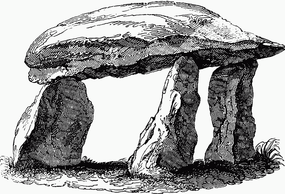
The cromlech at Drewe's Teignton
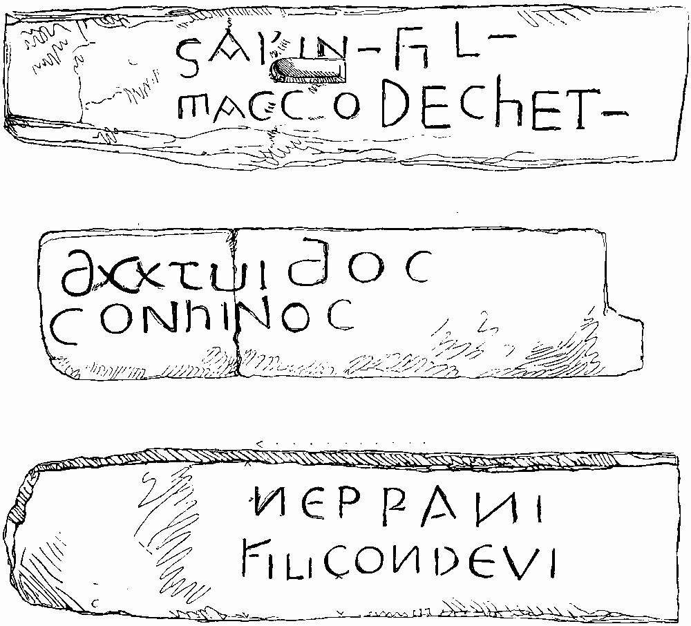
On the opposite page are representations of three ancient inscribed stones, from drawings made by my brother. Mr. Polwhele mentions another in Yealmton church-yard, of which I have no note, with the word Toreus inscribed on it.
No. 1. is at Buckland Monachorum, at the corner of a blacksmith's shop; it is seven feet two inches in height, fourteen inches wide at the top, and one foot six inches in the widest part.
No. 2. now forms a sill under the door of Lustleigh church. It is four feet in length, and 14 inches wide.
No. 3. is at Tavistock, on the site of the abbey. It stands seven feet above the ground, is 11 inches thick, and 21 wide.
Numerous tumuli, or barrows, occur in various parts of the county, on Haldon and other downs, particularly in the north of Devon. Many of them are of stone, which are sometimes called kairns: a few of those on Haldon have been opened; urns were found in them (fn. n7), and in one some Roman coins; fragments of urns were found in one that was opened in the parish of Moreton, and Roman coins, &c. in one in East Worlington.
Inscribed stones
Crosses. — The most remarkable ancient cross in the county is that at Copleston, in the parish of Colebrooke. It is a pillar about twelve feet in height, and about two feet square at the base, but declines a little in size as it ascends; at the top is a square hole, in which a cross is supposed to have been mortised. The sides are rudely ornamented with saltier-shaped crosses, &c.; on one side, near the top, is a niche, from which a figure appears to have been removed. At Lustleigh, in a lane near the church is a block of granite, about five feet in height, called the Bishop's Stone, which appears to have been the base of a cross: the sides have been worked into a regular shape, and on one of them may be traced the form of a coat of arms. In an enclosed field, on a farm called Stone, in the parish of East Worlington, is a square stone, about six feet five inches in height above the ground, into which it is sunk nearly to the same depth. At the top, on each side, is a cross.
Celts. — Mr. Polwhele makes mention of celts, most of them brass, found singly in the parishes of Chudleigh, Ilsington, and Buckfastleigh, and one north of Barnstaple. The Rev. Mr. Carrington found several in some kairns between Bridford and Christow; George Drake, Esq., of Ipplepen, has one of copper, found in the year 1820, in a wood belonging to him in that parish.
Roman Antiquities.
Considering that there are some undoubted Roman stations in this county, very few antiquities of that nation, and those not of great importance, have been discovered in it. It appears, from "Stukely's Itinerary," that a Roman tesselated pavement was found in Exeter, in Pancras-lane, behind the Guildhall, at the depth of eight feet. Some small remains of a tesselated pavement, and a few Roman medals, were found in 1777, in digging the foundation of Mr. Dennis's house in the High-street: and in 1778, some Roman Penates, in bronze, were discovered in digging a cellar under the house of Mr. Upham, in the same street, at the corner of Broadgate; two of them evidently meant to represent Mercury. (fn. n8) The female bust and the Roman altars, placed in the front of the house lately the property and residence of Richard Eales, Esq., were not found in Exeter, but were placed there by the learned Dr. Musgrave, who procured them from Bath, as appears by a passage in his Belgium Britannicum, where there is an engraving of the bust. An antique lar of iron was found near Hembury fort, in 1801. (fn. n9)
Westcote says, that a pot of gold and silver Roman coins was found in Exeter, near the castle; and others not far from the same spot, with a fair ring, which had a beautiful stone, representing Cleopatra with the asp. Thirty of the coins came into Westcote's possession: the latest was one of Antoninus Pius. In 1721, a pot of Roman coins was found near St. Martin's church: they were of Balbinus, Philippus, Julia Mæsa, &c. (fn. n10) Some Roman coins were found in the camp on Berry-head, about the year 1730; among others, one of the Emperor Claudius, with the figure of Victory on the reverse. Chapple says, that, in 1774, some Roman coins were found in an earthen vessel in St. Catherine's lane when some houses were rebuilt; one of Augustus Cæsar was in fine preservation: the same year, a fine medal of Domitian, in silver, was found by the workmen digging the foundation of the new hall, on the site of the castle. Mr. Chapple says, that, in 1774, Mr. George Baker showed him coins of Domitian, Trajan, Vespasian, Probus, and Valentinian, all found in or near Exeter. In 1779, coins of Vespasian, Probus, Carinus, &c., were found in altering a house for the Methodists' meeting.
Mr. Chapple speaks of a lachrymatory and Roman coins found near Seaton, supposed to have been the Moriodunum of the Iters. Some tumuli having been opened on Haldon, in 1793, three urns were found under a bed of flint, filled with ashes and bones; several Roman coins were found in these tumuli. In 1816, a labourer, digging for stone in the great barrow on the western side of Haldon, found several Roman coins of the later empire, which are in the possession of the Rev. John Templer. Some silver Roman coins were found about 1813, by some labourers repairing a hedge in the parish of Bishop's Morchard; four of these, two of Vespasian, one of Nerva, and one of Trajan, are in the possession of John Sillifant, Esq., of Combe. Roman coins have been found in a barrow, in the parish of East Worlington.
On excavating the ground, for the purpose of taking down and rebuilding Teignbridge, in 1815, the timbers of an ancient wooden bridge were discovered; and, underneath, the piers of another bridge of white ashler, apparently of Roman work. It appears, from the mention of it in the Domesday survey, that Teignbridge had given name to the hundred from a remote period. The remains of two ancient highways, the lower one of which was paved, were found under the channel of the temporary river. (fn. n11)
British and Roman Roads and Stations. (fn. n12)
"As it is allowed by all our writers, that the earliest trade of Britain, in whatever articles it consisted, was seated, from local circumstances, in this western part of the island, we may fairly conclude, that internal roads, the constant attendants on trade, and without which, indeed, it can hardly exist, must have been particularly numerous in Devonshire and Cornwall; and the fact seems to confirm this idea, for in no counties are we able to trace, especially since the last excellent survey made by the order of government, so many lines of communication between the places supposed to have been British towns.
"Of these, one principal road, converted afterwards by the Romans to their own use, passed through the whole length of Devonshire, from northeast to south-west, in its way to the great marts of trade on the Cornish coast. It enters the county from Dorsetshire (where it has preserved the British name of the Ikeneld-way) a little east of Axminster, to the right of the present turnpike-road; then proceeds with it by Kilmington and Shute-hill, to Dalwood-down, where it bears away from it on the left for the sake of keeping the ridge of the hill, which it does till it gradually descends by Honiton church to the house called the Turk's Head, where it crosses it, and runs direct to the large camp at Hembury, which was very probably a British post on it; from hence it ran by Lay-hill, Colstocks, Tale-water, Tallaton-common, and Larkbeare, near Whimple, to Streetway-head, being still known in this part of its course by the name of the Old Taunton Road. Here the ancient trackway is lost, but it probably continued nearly in the line of the present turnpike-road to Exeter, which was certainly the principal town of the Damnonii, (though we may not perhaps adopt the conjecture of Mr. Polwhele, that it is exactly delineated on a Damnonian coin). It crossed the Exe at a ford a little below the present bridge, which ford was the site of the ancient bridge, and ran through St. Thomas's by the causeway, now a nursery, to the village of Alphington, so over Haldon, leaving Ugbrooke, where there is a strong British camp, on the right. Some way beyond this, it bore off again from the present turnpike-road at Sandygate, and passing by King's Teignton, crossed the Teign below Newton Abbot, by a ford still called Hacknieldway; then leaving another British camp on its left, went over Ford-common, and again joined the modern road to Totnes, which we may fairly conclude to have been a British town, both from its being celebrated in the tales of our old historians, not only as the spot where Ambrosius and Uter Pendragon, but even where Brute himself landed, (and, whatever we may think of the matter of fact, it proves the idea of these early writers as to the traditionary antiquity of the place,) but also from the evident bend to the east, which the line of the road makes in order to pass through it. From hence it seems to have tended more westerly near Brent, and by an old circular camp near Boringdon park to the first ford upon the Tamar.
"A second road, which has every appearance of being British, seems to have run from the mouth of the Exe to the great camp at Woodbury, which it enters at the south-west gate, and leaves by the north-east, thence to Streetway-head, where it joins the Ikening-street, and proceeds with it to Hembury, so over Blackdown towards Taunton, in Somersetshire.
"Another of these trackways seems to have left Exeter on the northwest side of it, to have crossed the Exe at a ford near the Bonhay, below the Weare, and passing through Mr. Buller's fields, where it is still visible, continued in a straight line up Cleve-hill, close to Cleve-house, and so fell into the line of the modern Oakhampton turnpike-road, near which it joins another ancient road, still in good preservation, which ran from Crediton to Exeter and Haldon. This last road is very plain and straight, but keeps the hills as much as possible, seeming to have been once the great communication between Exeter, Crediton, Chulmleigh, and the whole north-west part of the county.
"A more decided road, which was afterwards used by the Romans, seems to have gone from Exeter to Molland Bottreaux, which there is much reason to conclude was also a British town: it is plain in the parish of Woolfardisworthy, in a line between the two, where is Berry castle, a circular fortification, and from hence through Witheridge and near Knowestone, directly in a line for Molland.
"From Seaton a road is said to run between Yerbury and the parish of Farway, to the camp at Hembury, before mentioned; thence by Collumpton and Bampton, leaving Dulverton a little on its right, and proceeding by the Ansteys to Molland.
"These roads, and many others, the traces of which have perished, or are too obscure to be spoken of with any certainty, were, probably, in existence long before the Roman invasion; and the conquerors adopted such of them as were most convenient for their own purposes, raising their crest always, and altering their line in some instances, according to their usual practice. There is, however, a local circumstance which renders it more difficult to trace these roads in Devonshire than in any other part of England, for the country is not only in the lower parts of it deeply enclosed, but the enclosures are formed by banks of such a height and thickness, as is unknown in the more northern districts; and in order to construct them, the elevated crest of the Roman road, which was near at hand, has almost in every instance fallen a sacrifice. That the principal Roman Way, however, was in the course of the British Ikeneld, we have the most evident proofs. It entered the county with it at Axminster, and, probably, proceeded with it towards Honiton, where the British Way, still bearing the name of Street, seems to have run north towards Hembury, and the Roman one south-west along the banks of the Otter, in the line of the present turnpike-road. Five or six miles west of Honiton, at a place called Fair Mile, the ridge of the Roman road was, in Musgrave's time (fn. n13), visible for some distance. It bent, according to him, somewhat to the left at Honiton Clist, entered the east gate of Exeter, went up St. David's hill to the old ford below the bridge, and thence straight to the top of Haldon. It is quite plain even at this day in the ascent to Haldon, on the right of the present turnpike-road; but just beyond the road leading from Mamhead to Sir L. Palk's crosses that road and continues on the left, being often seen in this direction at intervals, by Newton Bushell to Totnes, where Musgrave describes the crest as quite perfect. Totnes was therefore, probably, the Statio ad Durium Amnem. It is lost for some way to the west of this town; but being again visible near Brent, goes to Ridgway near Plympton, and thence straight for St. Budeaux, where it crossed the ferry into Cornwall at the station of Tamara, mentioned in Richard's sixteenth iter.
"Soon after the Ikeneld-street enters the east borders of Devonshire, it is crossed or joined by a very distinguished Roman road, the Fosse, in its way from Ischalis to Moridunum. Which of these terms is most proper to be used is indeed matter of doubt; for the latter road is so obscure in this part of its course, and the site of Moridunum so difficult to determine, that our best antiquaries have doubts upon the subject; and according as they are led to fix this station at Hembury, or Seaton, suppose the Fosse to fall into the Ikeneld near the first, or to cross it in its way to the second. For reasons which will be detailed more at large when I come to consider the claims of these two places to a Roman origin, I am inclined to prefer the latter, which is countenanced by the bearing of the Fosse when it is last seen distinctly at the back of Hinton St. George, and by the name of the village of Street, in the direct line between that spot and Seaton. The defenders of the contrary opinion suppose the Fosse to have inclined more west by Chard, and to have descended into the vale of the Otter, perhaps by Yarcombe, where a portion of a road with a high crest is said still to exist, and thence to the camp at Hembury. It is much to be wished, that the bearings of this Yarcombe road had been given us with more accuracy. General Simcoe, whose active and intelligent mind comprehended the whole military system of the Romans more fully than any gentleman of his county, but whose employment in the important duties of the profession of which he was a distinguished ornament left him hardly any leisure for these pursuits, was inclined to think that it was a fragment of a road bearing from Taunton towards Seaton; but as Roman remains of some consequence have been lately found at Chard, it is not impossible that a branch from the Fosse may have connected Ilchester and Exeter in this direction, by a shorter line than that through Seaton.
"An undoubted Roman road came from the central parts of Somersetshire towards Exeter, under the name (which never deceives us) of the Port-way: its high crest is particularly visible at Uffculme-common, about three miles west of Culmstock, and five north-east of Collumpton, and of a great breadth, running for above a mile, from South Appledore to Lennard-moor. It is still the turnpike-road from Taunton to Exeter, and was undoubtedly the very road from Bath travelled in the tenth iter of Richard.
"I have little hesitation in supposing another Roman road to have run from Exeter to Molland Bottreaux, in the line of the ancient British one. The greatest part of it can be travelled at present; and what makes the idea more probable, is, that passing through the British circular camp at Woolfardisworthy, with no apparent notice, it runs five miles farther to a Roman camp of the same name, Berry castle, in the north-east part of Witheridge parish, which is square, well situated on an eminence over the Dart, commanding a view beyond Molland to the borders of Exmoor, and the road from it pointing to Molland itself, beyond which it continues over Exmoor in the very line seen from Berry castle among the barrows, where Roman coins have been found, to Countesbury, on the coast near Linton, an undoubted Roman camp, and probably a station; and the communication with the northern channel in this direction must have been a point of considerable importance to Isca, whether as a British or a Roman city.
"The Romans had also a road from Exeter to Stratton, by the way probably of Oakhampton and Holsworthy; for in this line is Oldridge and Bradbury, or Broadbury castle, three miles north of Bratton-Clovelly, of an oblong form, 225 feet by 186, with a single vallum and ditch.
"There must have been some British or Roman town of great consequence towards the centre of Somersetshire, perhaps Alauna, near Taunton, and Uxella, supposed Bridgewater; for besides the other roads which we have marked as traversing Devonshire in that direction, a considerable one is visible on the north-east borders, coming from Taunton, under the name of the Rumansleigh, or Romansleigh ridge. It enters Devon a little northeast of Brampton, at the village of Clayhanger, crosses the road from Exeter to South Molton, a little beyond a house which stands at the junction of the Witheridge road; thence near a close in East Worlington parish, called Witchester, (in a barrow in which parish Roman coins were found,) near also to the square camp at Berry castle; so west-south-west to Beacon-moor, in the parish of Chulmleigh, leaving the town about one mile on the left, crosses the road from Chulmleigh to South Molton, near Cadbury, an ancient camp; thence through Elson, and crosses the Taw by an old ford to a farm-house called Ravington, in Burrington parish; thence over Burrington-moor, where are many barrows, and cross the Roborough road to Beaford-moor-head, near the direction-post in the crossway, a little east of the house so called; passing thence near Beaford and Wolley, it crosses the Torridge a little above its junction with the brook that comes from Wolley mill, it goes on to the parish of little Torrington, where it is distinctly visible pointing to Stratton, towards which it has not been farther traced. As in the first part of its course, near Bampton, it may have communicated with Molland, by the road through the Ansteys, or that from Berry castle, so it is probable that, near Torrington, another road from Molland to Stratton must have fallen into it. The beginning of such a road is visible between Molland and South Molton; but as to any road in Hollocombe parish, with which the Devon antiquaries have supposed it to be connected, such road, if it exists, must have been part of that which I last mentioned between Stratton and Bradbury castle, in the way from the former station towards Exeter.
"An old road in this north part of the country is said to have run from Molland towards Barnstaple, near which place, one mile to the north, is Roborough, a large irregular camp; this road went west of the present turnpike-road, in the valleys, and fell into the modern road at Landkey: from thence it has been conjectured to proceed towards Hartland, which is by no means unlikely, but the line has never been well examined. Stukely supposes, that a road went from Seaton in a direct line across the country, passing the Otter at Harpford; but neither has this been followed by any accurate observer. A piece of a road, as I before mentioned, is said to exist at Yarcombe, near Otterford, in the north-east part of the county, leading towards Honiton or Hembury, and another on the Wolborough hills pointing to Dartmouth, but nothing more determined is known of either.
"Having thus endeavoured to trace the Roman roads in a county, where, from local circumstances, the attempt labours under peculiar difficulties, we come now to fix the sites of the Roman stations; and here also we find the subject involved in much obscurity. The principal Roman station in Devonshire, Isca Damnoniorum, appears, however, most decidedly, to have been at Exeter. Tesselated pavements, coins, Roman idols, and other antiquities dug up within its precincts, stones with Roman inscriptions seen by Leland in its walls, and British as well as Roman roads proceeding from it in every direction, seem to settle this question beyond doubt; and Exeter has the honour to which but few cities in the island have such clear pretensions, of having been the capital of the British tribe, the Roman province, and the modern county. Indeed, so strong is its claim to be considered as Roman, that Horseley, who denies it the name of Isca, allows it in express words to be some other Roman station. The mistake of that learned antiquary on the subject is one of the few errors in his excellent work, and he was betrayed into this by two unlucky circumstances: first, the imperfect state of English geography in his time, when no roads had been measured, or the situation of towns determined with any accuracy, and, as he himself confesses, no Roman ways known to exist farther west than the limits of Dorsetshire; and, in the next place, the blunder (as it is now allowed to be) of an early transcriber of Antonine's Itinerary, who has confounded the twelfth iter from Calleva to Isca, with that immediately subsequent from some station in Wales, (probably St. David's,) to Uriconium. Being therefore without any guide at all in one case, and with a mistaken one in the other, Horseley was led to remove Isca Damnoniorum from Exeter, and to place it first at Ilchester, then at South Petherton, and at last at Chiselborough. In this he has been followed only by Mr. Strutt, of Essex, and Mr. Henry, of Edinburgh; both, like himself, perfect strangers to the county, and the latter, (an author of much merit in another line, but little conversant in these pursuits,) professes himself to have been determined solely by Horseley's reasons, when the only reasons Horseley has produced (fn. n14) are, that he 'sees in the map a place called Chiselborough, which sounds like antiquity, and not very unlike Isca.' Of the force of this reason every one must judge for himself. In fact, the mistake in Antoninus being now evident, and the towns of Leucarum, Nidum, and Bomium, which the twelfth iter, in its corrupted state, would fix in the neighbourhood of Isca Damnoniorum, being all agreed to be in Wales, near Isca Silurum, the only reason for removing the former of these stations from Exeter has ceased to exist.
"It seems indeed to be allowed, that the distances west of Old Sarum, both in Antonine and Richard, (the latter having probably copied from the former,) are very inaccurate. This however by no means affects the situation of Exeter, which answers to the distance of Isca from Durnovaria, viz. 51 miles in Antonine, and 53 measured, and wherever in this interval we may choose to fix Moridunum, (respecting which the numbers are certainly erroneous,) it has nothing to do with the present enquiry. Exeter, therefore, from its antiquities and the roads conducting to it, must be allowed to be a Roman town, and from its near agreement with the itinerary distance, must certainly have been Isca Damnoniorum.
"The star which misled Horseley in this instance has shed its unlucky rays upon a still greater character, the geographer Ptolemy, in the very same instance; for by an evident and gross error, the latter has not only confounded Isca Damnoniorum with Isca Silurum, but has made a third town, Legio Secunda Augusta, out of the latter; nor will Mr. Polwhele's ingenious conjecture, that the second legion may have been stationed at Exeter in Ptolemy's time, excuse the mistake of the Greek writer; for in stating Isca (and by its situation among the Damnonian towns he must mean Isca Damnoniorum) as in the latitude 52° 45ft, and Legio Secunda Augusta, in 52° 35ft, he evidently took them for two different places.
"But whatever obstacles may have thus impeded our antiquaries in determining till lately the situation of Isca, they are trifles compared to the difficulties which still attend our researches on that of Moridunum. This place has been fixed by different respectable authorities at Eggardon, Hembury, and Seaton. Horseley contends for the first of these, in opposition to the numbers in the itineraries, which in these western parts are supposed to be corrupted; besides, however, his disagreement with Antonine, (who in two different iters asserts Moridunum to be 36 miles from Dorchester, and 15 from Exeter, when Eggardon is only nine from the first of these towns, and 41 from the second,) it is to be observed, that the camp at Eggardon is irregular, with no antiquities of any kind found in or near it, looking more like a British than a Roman fortress, and more likely to be the Dunium of Ptolemy, (which that geographer places among the Durotriges,) than the Moridunum of the itineraries, if Maiden castle, near Dorchester, had not still better pretensions to the name of Dunium than either.
"Hembury has a fairer claim to be considered as Moridunum. It is not far (about two miles and a half) from the great western road, about 14 miles from Exeter, and 35 from Dorchester. It is evidently connected with this road, and the distances agree with those in the itineraries. Two old roads at least, one from Somersetshire towards Exeter, and another from Seaton, are said to meet under its ramparts. Add to this, that the road from Seaton to it is called the Street, and close under it are Aggerdon fields. It is objected to these plausible arguments, that the form is irregular, and that few antiquities exist in its neighbourhood. I should have said none, if my friend, Mr. Harford, had not lately dug up an iron lar, which has every appearance of being Roman, and there is a tradition in the neighbourhood that a coin or two have been found there.
"Seaton is supposed to have been Moridunum by Camden, Musgrave, and Stukely. The tradition of the inhabitants is, that it was once a great town; and Leland observes, 'there had been a notable harbour,' of which indeed evident marks appear at present. Stukely even speaks of a square camp called Honeyditches, only half a mile to the west of it, and that much wrought stone had been dug up there; but of this fort no traces are now to be found. One road, as I observed, called the Street, runs from it towards Hembury, and another is said to have gone in a more direct line to Exeter, crossing the Otter at Harpford. The Fosse road, too, which (wherever Moridunum was) certainly led to it, points evidently towards Seaton in the latter part of its course, though I am far from asserting it may not have thrown off a branch towards Exeter by Chard and Hembury. But a circumstance that weighed much on my mind, when in company with my excellent friend, Mr. Leman, I traced this celebrated road from the coast of Lincoln to that of Devonshire, was, that we seldom descended into any large valley without being able to guess at the line of the Roman way, by a tumulus, or camp, or other conspicuous object on the brow of the opposite hill; and when we finally lost this road, like all our predecessors, on the Somersetshire side of the hill, called Windwhistle, which is just on the borders of the two counties, we no sooner ascended that eminence, than a small bay of the sea, with the land bending in towards it on both sides, was visible in a line before us, which once formed the entrance of the harbour, and is known by the name of Seaton Gap. The agreement of this object to many of the same kind which we had noted down in our careful examination of the road for near 300 miles, could not fail of making an impression in favour of Moridunum being near Seaton. I am therefore, on the whole, inclined, though not without some hesitation, to adopt the opinion of Camden on this subject. The want of agreement indeed with the distance on both sides of the itinerary numbers, (being only 31 or 32 from Dorchester, and at least 20 from Exeter,) with the absence of all Roman remains (fn. n15), (however the latter may be in some degree accounted for by the encroachments of the sea,) must always lead a writer to be cautious on so obscure a point. The idea of Dr. Mason, that a road bearing to Seaton from Somersetshire is called Morwood's Causeway, (quasi via ad Moridunum) is too hypothetical for us to adopt.
"The stations of Isca and Moridunum are known to be in Devonshire, from their position in Antonine's Itinerary; but we are indebted to that of Richard for the information of two others. These are both mentioned in his 16th iter; ad Durium, and Tamara; the first of these, was undoubtedly on the Dart, and Totnes, from its traditional antiquity and its situation, not only on the same river, but on a certain Roman road, seems to me to have every claim to it. Tamara, from the name only, has been fixed at Tamerton, but all we know of it is, that it lies somewhere near the Tamar; indeed so few Roman remains have been found at most of the places specified in the itineraries under names of this sort, as ad Pontem, ad Trivonam, ad Sturium amnem, &c. (ad Tisam being, I believe, the sole exception,) that it has been conjectured they may have been only mansions, where persons were placed by the government (as we know to have been the Roman custom) to provide horses for travellers, and more particularly on the sides of rivers, to superintend the ferries for conveying them and their luggage to the opposite bank. Of course, it is more difficult and less important to point out their precise situation. The names indeed of these posts point out, in many cases, a different class of restingplaces from the towns or stations, and more nearly approaching to our inns: thus we read in Antonine's Itinerary, ad Aquilam, ad Columnam, ad Septem Fratres, ad Rotam, ad Palmam, and the like.
"Besides these, we are obliged to Richard for the names of two British towns, which his map places among the Cimbri, in the north of Devonshire, Termolus and Artavia; and for these we have the additional authority of the geographer Ravennas, who states, in his corrupt Latin, Termonin and Mostevia as two towns in this part of the country, not far distant from Isca. It will be always useful in consulting Ravennas to remember, that, if not a Greek himself, he composed his work from a Greek map, and that the later Greeks always disfigured names and places of foreigners, with the arrogant carelessness of the modern French. Thus Theophanes calls the Italian cities Verona and Brixia by the names of Beroi and Brincas; and Leo the Deacon corrupts Martyropolis into the barbarous word Myctarsim. (fn. n16) Termolus and Artavia therefore were certainly ancient cities in this part of the country; and I have no hesitation in fixing the first of these at Molland Bottreaux, where the number of roads pointing to it on all sides, and an encampment of an oblong figure, (200 paces by 96,) with another perfectly square, (probably a summer-camp,) about two miles distant, still mark the site of the station: near the latter, too, is an evident piece of a raised road.
"We cannot speak with so much confidence of Artavia: it is supposed, from the resemblance of the name only, to have been near Hartland Point. But besides that the British town in Richard's map seems to be much more inland, no coins have been found, or roads traced, or fortifications known, except Clovelly Dykes, in the neighbourhood of Hartland. I was once of opinion that this camp was constructed by Inguar, and the brother of Halden, when they landed in this part of the country from Wales with 23 ships (fn. n17); but, as Mr. Swete observes, the Danes had seldom time in their plundering incursions to raise fortifications of this magnitude: it is irregular, surrounded with three deep ditches, and more likely to be Saxon than either Roman or British; if the latter, it is possible it might have been Artavia, but this possibility is all we have to produce for it.
"Exactly on the same suspicious ground is the claim of Denbury to be the Devionisso of Ravennas, though it is called Devenesbury in Domesday, and lies near the British road by Newton Bushell; or Dartmouth Clifton Ardness to have been Ardea; or Bampton, though it may have had warm springs, to have been a Roman town under the name of Bathrumpton. Stansborough has a little more right to be considered as Stone: it is circular, large, and has a number of barrows about it; it still gives name to the hundred, (a proof of its ancient consequence,) and the road on Wolborough hills may probably be connected with it; but the only places of this description which I look upon to have evident claims to the title of Roman camps or stations are Countesbury, on the northern channel; the camp in Sir Thomas Acland's park at Killerton, where coins have been found, and which is well situated for a station between Taunton and Exeter; Bradbury, between Exeter and Stratton; and Berry castle, in Witheridge, between Exeter and Molland. Perhaps, too, Shorsbury, 10 miles north-east of Barnstaple, at a meeting of roads half way on the line between this last place and Countesbury. It is an ingenious observation of Mr. Polwhele's, that the few large Roman camps existing in Devonshire argue the Damnonii to have surrendered without any considerable resistance.
"If Hembury be not regarded as Moridunum, I am inclined to allow it to have been a British camp occupied by the Romans; it is an irregular figure, but tending to circular. Oval stones, used by the Britons for slings, have been found in it, yet its lofty situation, commanding the Vale of Otter, the ancient roads (one of them with the name of Street) running up to it, the marks of two raised hills (Prætoria they are called) within the area, and some possible marks of occupancy, the Roman lar, and it is said coins dug up near it, with its very convenient distance from both Exeter and Seaton, are strong proofs of its having been possessed by the latter people.
"It is to be lamented that so extensive a county, inhabited at all times by an active and industrious people, and of late years, in particular, illustrated by the labours of many ingenious men, should still have such a cloud hanging over the period of its early history. A few insulated camps with no remains in them, and detached pieces of roads (the end and begining of which are equally unknown), form the sum of its Roman antiquities; and of the stations and cities which it once contained. Exeter only, and perhaps Molland Bottreaux, have been fixed with any degree of certainty."