Ancient and Historical Monuments in the County of Gloucester Iron Age and Romano-British Monuments in the Gloucestershire Cotswolds. Originally published by Her Majesty's Stationery Office, London, 1976.
This free content was digitised by double rekeying. All rights reserved.
'Temple Guiting', in Ancient and Historical Monuments in the County of Gloucester Iron Age and Romano-British Monuments in the Gloucestershire Cotswolds(London, 1976), British History Online https://www.british-history.ac.uk/rchme/ancient-glos/pp116-119 [accessed 1 May 2025].
'Temple Guiting', in Ancient and Historical Monuments in the County of Gloucester Iron Age and Romano-British Monuments in the Gloucestershire Cotswolds(London, 1976), British History Online, accessed May 1, 2025, https://www.british-history.ac.uk/rchme/ancient-glos/pp116-119.
"Temple Guiting". Ancient and Historical Monuments in the County of Gloucester Iron Age and Romano-British Monuments in the Gloucestershire Cotswolds. (London, 1976), British History Online. Web. 1 May 2025. https://www.british-history.ac.uk/rchme/ancient-glos/pp116-119.
TEMPLE GUITING
(16 miles N.N.E. of Cirencester)
Seven monuments connected with prehistoric and Roman settlement are adjacent to roads which probably mark ancient ways. The road over Kineton Hill, passing monuments (2) and (3), is followed by the parish boundary. Monuments (4–6) lie by the ridgeway (Buckle Street) from Bourton-on-the-Water to Willersey. Monument (10) is close to the Salt Way.
The pit-alignment (4) is one of three examples known in the area of this volume and its high situation is very unusual (see p. xxvii).
Romano-British attention to Bronze Age round barrows is indicated by finds in two excavations. Pottery, including samian, together with a coin of Antoninus Pius was found in the ditch of a barrow (SP 08292910), ¼ mile S.W. of Ford and nearly 900 ft. above O.D.; the present whereabouts of the pottery is unknown. (fn. 1) At SP 108285, in a bell barrow 900 ft. above O.D. and 400 yds. W. of (6), (see plan, p. 118), six Romano-British sherds were found in topsoil and top fill of the ditch, and two 4th-century coins (Constantius II and Valens) were found in crevices between stones at the top of the barrow. (fn. 2)
(1) Beckbury Camp (SP 064299), univallate hill-fort, unexcavated, encloses 5½ acres on the edge of the plateau above Hailes Wood.
The N. and W. sides are defined by the steep slope of the escarpment; on the S. and E. the bank is about 25 ft. wide and rises 5 ft. above the interior. The entrance was probably in the S.W., where there is a 40-ft. gap between the end of the bank and the edge of the escarpment. A low scarp continuing the line of the bank across the gap is probably a natural feature. Fire-reddened stones are exposed in the outside face of the bank near A–B and may also be seen in the field wall on the bank, E. of the entrance. Except for a short length at the N. end, the outer ditch has been levelled.
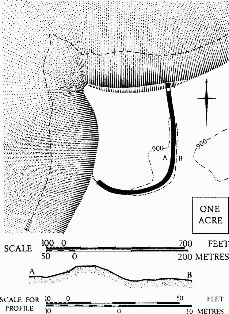
Temple Guiting. (1) Beckbury Camp. Plan and profile.
A single Iron Age sherd with stamped decoration is a surface find (PPS, XXXIV (1968), 427, No. 19). Roman coins are said to have been found on the site.
W. St. Clair Baddeley, A Cotteswold Shrine . . . (1908), 7. TBGAS, LII (1930), 178, n. 44. Witts (1883), 4–5, No. 9.
(2) Romano-British Settlement (SP 13252830), at Rook Pool Piece, ploughed out, covers at least 3 acres, about 600 ft. above O.D., on gently rising ground immediately W. of the road from Bartonhill Farm to Hinchwick which here follows the shallow valley bottom. The settlement is 1¼ miles N. of (3), which lies close to the same road.
Occupation debris is of 2nd to 4th-century date; concentrations suggest at least twelve small buildings. The site probably extended into an area of plantation on the N., and possibly E. to the opposite slope, also rising gently from the road.
Finds, now in Gloucester City Museum, include three 4th-century coins (Constantius II and Gratian), abundant pottery with samian and Oxfordshire colourcoated vessels, a fragment of sandstone quern decorated with concentric incised lines, Stonesfield slate possibly from the area of (3), and a fragment of dressed limestone. Other dressed blocks have been reported.
TBGAS, 87 (1968), 203, No. 6.
(3) Romano-British Cemetery and probable Settlement (SP 1226), on Kineton Hill, is known from accounts of finds made during quarrying. Burials, pottery and coins were reported; they are not closely located, but probably were near SP 128262. Fifteen recorded interments included inhumations in stonelined graves, a wooden coffin, and cremations; the skull of one inhumation was at the feet, of another at the knees. Finds, in the Royce Collection in Bristol City Museum, include samian sherds, boot-nails, a bronze bracelet, an ornamented rectangular bronze stamp and a stone spindle-whorl.
A mediaeval building now recognised in the vicinity may be the structure thought in 1882 to be Roman.
TBGAS, VII (1882–3), 69–80; 83 (1964), 12–13; 77 (1958), 61–5 (mediaeval).
Note: The parallel alignments apparent in monuments (4), (5) and (6) suggest the possibility of an integral complex covering 80 acres or more. Intersections of ditched features indicate phases of development. The pit-alignment (4) is a type known elsewhere to be of the late Iron Age or of the early Romano-British period. No surface finds have been made, but two 4th-century coins came from the barrow W. of (6).
Markings of natural origin are widespread on air photographs of the area and obscure the nature of crop-marks ½ mile S. of (6), at Bembro (SP 107269). (N.M.R., OAP 1026/1/337–9; 1026/2/333–45.)
(4) Pit-alignment (SP 10962798–SP 11052805), S.W. of Lots Barn (Plate 56 and plan on p. 118), extends for 130 yds. from S.W. to N.E. and is probably incomplete.
N.M.R., OAP SP 1127/9/325–30; 1128/4/322–3.
(5) Enclosures and Ditches (SP 10962798–SP 114278), probably late Iron Age and Romano-British, show as crop-marks (Plate 57). Two clear ditched enclosures of irregular rectilinear form, each about 1 acre in area, have an entrance midway along the S.E. side (plan, p. 118). There are indications of an internal enclosure in the E. angle of the western of these enclosures, and there are very faint signs of a small rectangular enclosure attached to the N. side of pit-alignment (4).
N.M.R., OAP SP 1127/1, 3–6 (Baker); 1127/7/338–43. C.U.A.P., OAP AYF 65–8, AZN 24–8; VAP K17S 208–9.
Arch J, LXXI (1964), 15, Nos. 35 and 36.
(6) Enclosure and Ditches (SP 112285), probably late Iron Age and Romano-British, show as crop-marks extending S.E. from Charnal Plantation to beyond Lots Barn (plan, p. 118).
N.M.R., OAP SP 1128/1 (Baker). C.U.A.P., OAP AXT 55, 57, AYF 70–4.
(7) Ditch (SP 114287), undated, extends across a broad ridge, N. from Charnal Plantation for about ⅓ mile, as a narrow crop-mark in arable ground; it may have continued formerly to N. or S. (plan, p. 118).
N.M.R., OAP SP 1129/2/54–7.
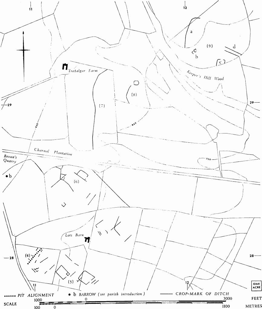
Temple Guiting. (4) Pit-alignment. (5)–(9) Enclosures, Ditches etc.
(8) Ditch (SP 11632900), undated, about 250 yds. E. of and roughly parallel with the N. part of (7), is visible on air photographs over a distance of some 450 yds. Near its N. end are faint traces of a small polygonal enclosure about 100 ft. across (plan, p. 118).
N.M.R., OAP SP 1129/1, 2 (Baker).
(9) Enclosure, Ditches and other Features (SP 121293), undated, N. of Keeper's Hill Wood and about ¼ mile N.E. of (8), comprise crop or soil-marks as follows: (a) Ditch, at least 300 ft. long, bowed out to the W. across a spur which falls gently S.E. (b) Traces of rectangular platforms on a gentle S.E. slope. (c) Enclosure, partly obliterated in the woodland, on a reentrant valley floor. (d) Two almost parallel banks, possibly ditched, or ploughed-down lynchets, at least 130 yds. long, extending down the gentle slope to the valley floor. Plan, p. 118.
N.M.R., OAP SP 1229/4/50–3.
(10) Enclosure and Ditch (SP 05542684), undated, on Sudeley Hill, show as crop-marks on the flat ridge top, 150 yds. E. of the Salt Way. The enclosure has a narrow ditch with sides both straight and rounded enclosing at least an acre. Only one entrance is certain, near the S.E. angle; part of the W. side has been destroyed by quarries. N.N.W. of the enclosure a length of ditch extends for at least 80 yds., towards a point where O.S. records show that Roman coins were found in 1882. A gap near the N. end of the recorded stretch indicates that the ditch was probably part of an enclosure complex (cf. (6)).
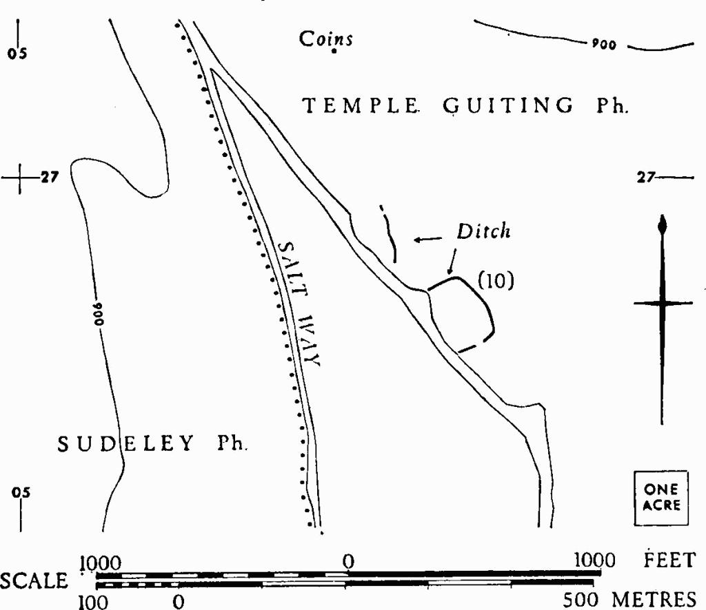
Temple Guiting. (10) Enclosure and Ditch.
C.U.A.P., OAP ASM 25–6.
(11) Enclosure (SP 09172750), S. of St. Mary's Church, shows as a crop-mark (Plate 54) at the junction of Cotteswold Sand and Inferior Oolite, on ground which slopes gently E. to the R. Windrush, about 100 yds. away. The enclosure lies S. of the remains of deserted mediaeval or later settlement which lie between it and the church, and is differently aligned. It covers about ¾ acre and has a gap 30 ft. wide in the S.E. side.
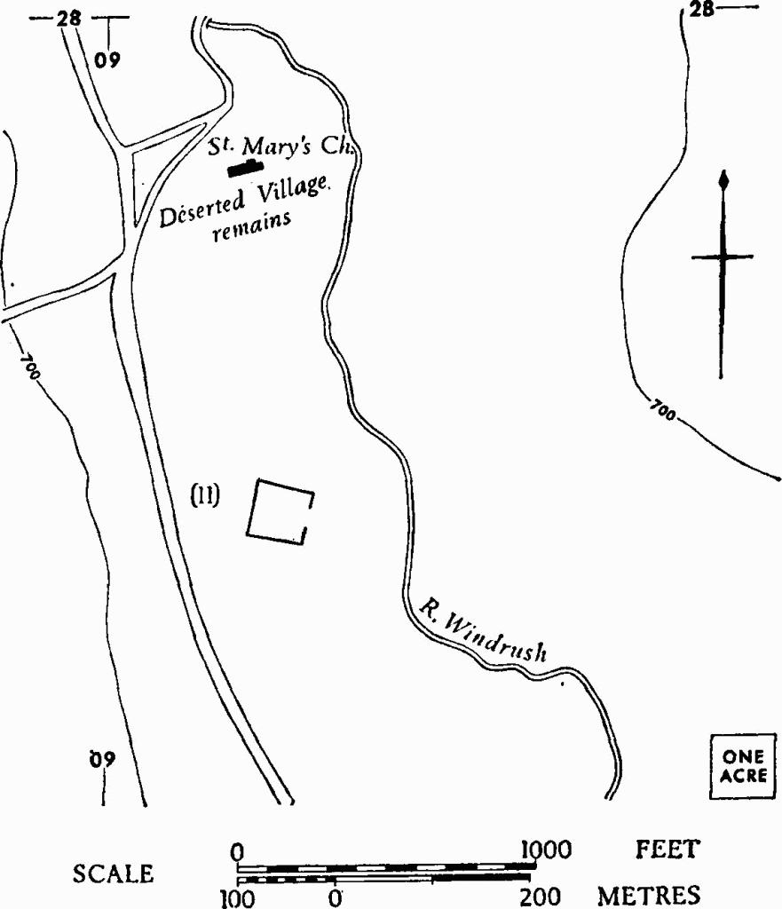
Temple Guiting. (11) Enclosure.
C.U.A.P., OAP ABY 98.