Ancient and Historical Monuments in the County of Gloucester Iron Age and Romano-British Monuments in the Gloucestershire Cotswolds. Originally published by Her Majesty's Stationery Office, London, 1976.
This free content was digitised by double rekeying. All rights reserved.
'Kempsford', in Ancient and Historical Monuments in the County of Gloucester Iron Age and Romano-British Monuments in the Gloucestershire Cotswolds(London, 1976), British History Online https://www.british-history.ac.uk/rchme/ancient-glos/pp68-69 [accessed 30 April 2025].
'Kempsford', in Ancient and Historical Monuments in the County of Gloucester Iron Age and Romano-British Monuments in the Gloucestershire Cotswolds(London, 1976), British History Online, accessed April 30, 2025, https://www.british-history.ac.uk/rchme/ancient-glos/pp68-69.
"Kempsford". Ancient and Historical Monuments in the County of Gloucester Iron Age and Romano-British Monuments in the Gloucestershire Cotswolds. (London, 1976), British History Online. Web. 30 April 2025. https://www.british-history.ac.uk/rchme/ancient-glos/pp68-69.
KEMPSFORD
(9 miles S.E. of Cirencester)
An approximately circular enclosure about 70 yds. across (SU 19209715), E. of Dudgrove Ham Barn, survives as ploughed banks with interior ditches; it is undated and has been classed with circles of 'Highworth type' (fn. 1) (Plate 64).
A 2nd-century cooking-pot, now in the Ashmolean Museum, was found beside the R. Thames at Hannington Bridge (SU 174961). (fn. 2)
All monuments lie on gravel terraces of the R. Coln and R. Thames, between 250 ft. and 300 ft. above O.D. Some rings shown on the plans may relate to Bronze Age barrows (see p. lv).
(1) Roman Settlement (SP 150005). Two wells discovered in a gravel-pit at Horcott lay 30 yds. apart; both were lined with stone. Pottery recovered from the wells and from a nearby pit was attributed to the 3rd century. A block of Oolitic limestone with a circular perforation, found at the bottom of one of the wells, is in Cirencester Museum.
Gloucestershire Countryside, IX (1957), 154. H. E. O'Neil in Studies in Building History (ed. Jope, 1961), 36.
(2) Enclosures, Track and Linear Ditches (SU 141991), undated, are revealed by crop-marks covering some 18 acres N.W. of Rhymes Barn.
N.M.R., OAP SU 1499/2/409–11; 1499/3.
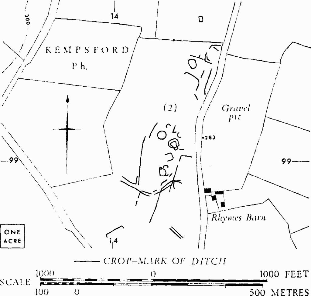
Kempsford. (2) Enclosures etc.
(3) Enclosures and Linear Ditches (SU 161974), undated, show as crop-marks extending over about 30 acres N. of the village. A and B mark the position of further enclosures, less well defined. Plan, p. 69.
N.M.R., OAP SU 1597/1/418–21.
(4) Enclosures and Linear Ditches (SU 168995), undated, show as crop-marks covering about 5 acres on the W. bank of the R. Coln, N.W. of Whelford (plan opp. p. 55, s.v. Fairford).
Air photograph: Allen, OAP 1368.
(5) Enclosure (SU 180993), undated, shows as a cropmark N.E. of Whelford (plan opp. p. 55).
C.U.A.P., OAP AYI 17.
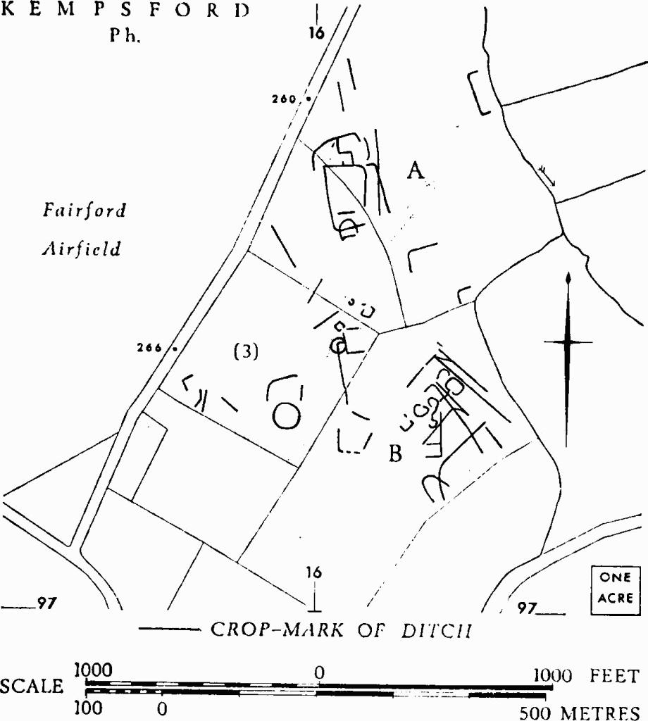
Kempsford. (3) Enclosures etc.
(6) Enclosures (SU 184978), undated, include small circular, penannular and D-shaped features, W.S.W. of Dudgrove Farm; they show as crop-marks over about 18 acres on a low hill (Plate 62).
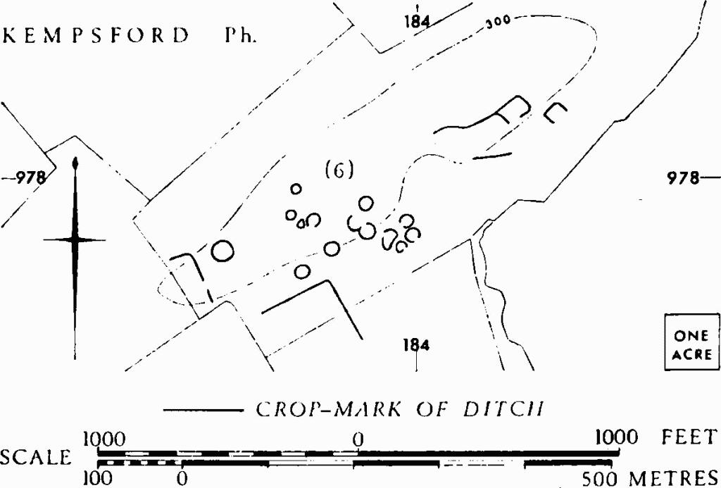
Kempsford. (6) Enclosures.
C.U.A.P., OAP LY 86–7, AYI 2–3.
Arch J, CI (1944), 16, Pl. V, B. Oxon, VIII-IX (1943–4), 95, No. 2.
(7) Enclosures, Tracks and Linear Ditches (SU 180966), undated, are revealed by crop-marks extending over some 70 acres along the N. bank of the R. Thames around Manor Ham Barn. One of the focal points of the settlement complex appears to be an 'open space' around a ring-ditch (SU 18359672); there are only slight signs of other ditches encroaching on its S.W. side (Plate 60). See also p. lv.
C.U.A.P., OAP AYI 4. N.M.R., OAP SU 1896/8/422–32.
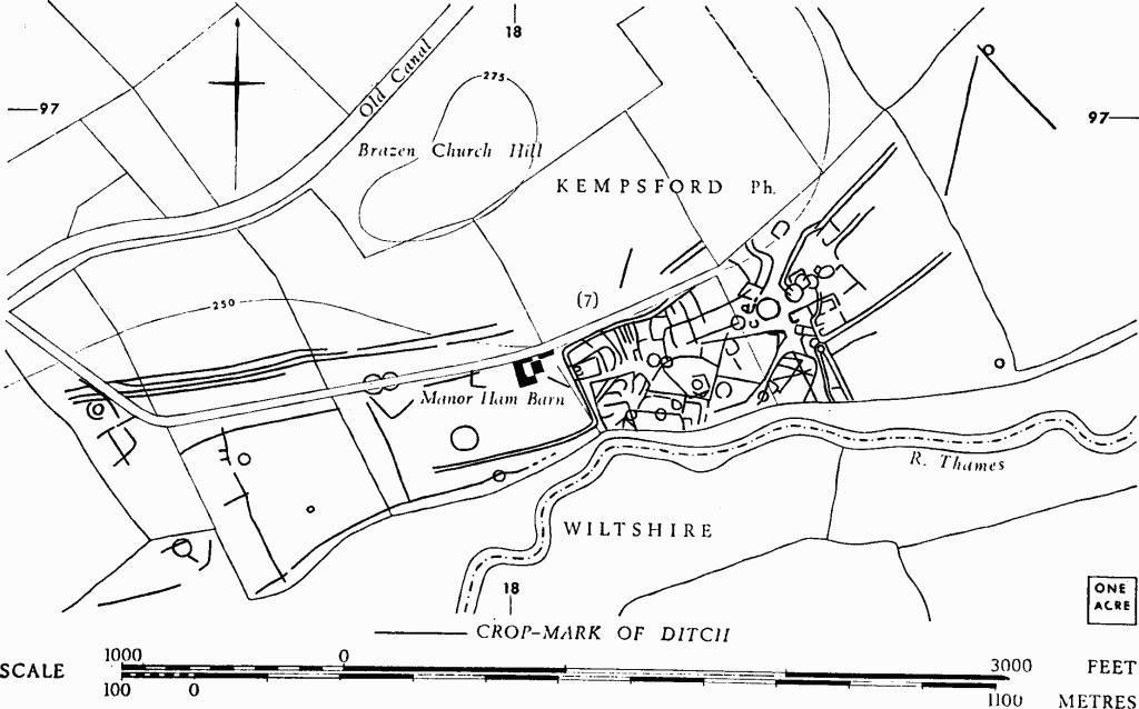
Kempsford. (7) Enclosures, Tracks and Linear Ditches.