Ancient and Historical Monuments in the County of Gloucester Iron Age and Romano-British Monuments in the Gloucestershire Cotswolds. Originally published by Her Majesty's Stationery Office, London, 1976.
This free content was digitised by double rekeying. All rights reserved.
'Sapperton', in Ancient and Historical Monuments in the County of Gloucester Iron Age and Romano-British Monuments in the Gloucestershire Cotswolds(London, 1976), British History Online https://www.british-history.ac.uk/rchme/ancient-glos/pp99-100 [accessed 30 April 2025].
'Sapperton', in Ancient and Historical Monuments in the County of Gloucester Iron Age and Romano-British Monuments in the Gloucestershire Cotswolds(London, 1976), British History Online, accessed April 30, 2025, https://www.british-history.ac.uk/rchme/ancient-glos/pp99-100.
"Sapperton". Ancient and Historical Monuments in the County of Gloucester Iron Age and Romano-British Monuments in the Gloucestershire Cotswolds. (London, 1976), British History Online. Web. 30 April 2025. https://www.british-history.ac.uk/rchme/ancient-glos/pp99-100.
SAPPERTON
(5 miles w. of Cirencester)
'Green Ditches', (fn. 1) possibly a hill-fort, is said to have been a small bivallate enclosure on the scarp edge S.E. of Frampton Mansell. It was levelled c. 1845 and the site has not been identified.
A Dobunnic gold coin inscribed BODVOC was found in the parish in 1901, (fn. 2) and an Armorican base silver coin (Coriosolitan, class II) is recorded from Frampton Mansell. (fn. 3)
Two hoards of 3rd-century Roman coins are recorded from the vicinity of Frampton Mansell: the Lark's Bush hoard, found buried in pots in 1759, was mostly dispersed at the time; (fn. 4) the other hoard, of 70 coins apparently associated with a skeleton, came to light in 1844 during construction of the Sapperton railway tunnel, probably near its S.E. end. (fn. 5)
Monument (1), an unusual Romano-British embanked enclosure with internal structures, lies partly in Coates. Adjacent buildings (Coates (2)–(4)), now separated from the enclosure by the parish boundary, are described here, as forming part of a complex, conceivably religious (see pp. 1, li).
A villa in Hailey Wood (SO 9601) is indicated by reports of tesserae and pottery communicated by Mr. R. Reece.
(1) Roman Settlement (SO 96450036), 'Tunnel Mouth Camp', ploughed over, lies 230 yds. S.S.W. of the S. end of the Sapperton canal tunnel, on a slight knoll above a gentle slope to S.E. (Plate 49).
The sharply quadrangular enclosure, with entrance at E., is formed by three banks and two ditches measuring about 70 ft. across; the interior covers about 2/3 acre. The inner bank is still over 1 ft. high and contains large limestone slabs, possibly from the facing of a substantial wall. A building within the enclosure is defined by traces of a stone wall and a spread of pottery, tile, sandstone and reddened limestone fragments extending for about 60 ft. along the inner bank, S. of the entrance. Similar debris is associated with three walls offset from the N. bank. Finds are in Gloucester City Museum.
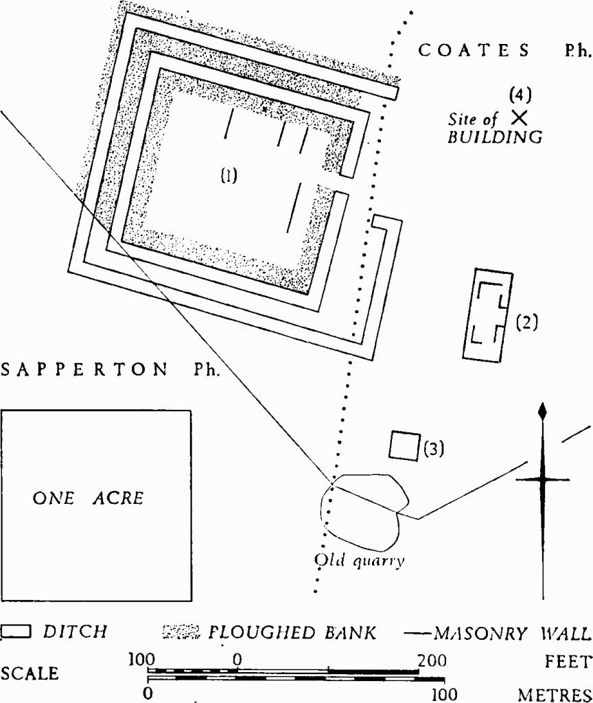
Some 30 yds. E. of the enclosure, crop-marks disclose a Building, (Coates (2)), probably Roman; its foundations measure 100 ft. by 40 ft. and there are indications of internal walls.
Another Building (Coates (3)), probably Roman, shows as a crop-mark 30 yds. S.W. of the foregoing. It is about 30 ft. square and is marked on the ground by scattered limestone slabs.
Some photographs (e.g. C.U.A.P., OAP FY 26, 29 and GX 0028) show a rectangular feature outside the S. wall of (1), but on the ground there is no confirmatory evidence of a building.
C.U.A.P., OAP ASM 40–3.
Arch J, CIX (1952), 24, fig. 1. JRS, LIX (1969), 128.
The site of a Roman Building (Coates (4)) is indicated by large limestone slabs, sandstone tiles and pottery, about 60 yds. N. of Coates (2). Sherds collected there include samian ware of the late 1st or early 2nd century, and 4th-century Oxfordshire colour-coated ware.
Monuments in Sherborne and Windrush.