An Inventory of the Historical Monuments in the City of Cambridge. Originally published by Her Majesty's Stationery Office, London, 1959.
This free content was digitised by double rekeying. All rights reserved.
'Secular Buildings: Public Buildings', in An Inventory of the Historical Monuments in the City of Cambridge(London, 1959), British History Online https://www.british-history.ac.uk/rchme/cambs/pp304-313 [accessed 1 May 2025].
'Secular Buildings: Public Buildings', in An Inventory of the Historical Monuments in the City of Cambridge(London, 1959), British History Online, accessed May 1, 2025, https://www.british-history.ac.uk/rchme/cambs/pp304-313.
"Secular Buildings: Public Buildings". An Inventory of the Historical Monuments in the City of Cambridge. (London, 1959), British History Online. Web. 1 May 2025. https://www.british-history.ac.uk/rchme/cambs/pp304-313.
Secular Buildings, Etc.
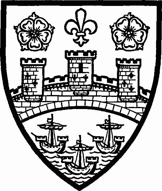
Cambridge Castle Arms
(77) Cambridge Castle, motte, remains of bailey and Edwardian and Civil War defensive earthworks, stands on the highest ground adjacent to the city centre, on a spur called Castle Hill, some 300 yds. N.N.W. of Magdalene Bridge. For evidence of Roman occupation of the site see Monument (14). No pagan Saxon remains have been found; later Saxon finds include a number of important carved stones (see below). In 1068 William I gave orders for a castle to be raised at Cambridge (Ordericus Vitalis, Hist. Ecc. (ed. A le Prevost, Paris, 1835–55), II, Bk. IV, Ch. IV, 185; this passage was probably derived by Orderic from William of Poitiers, and, if so, is contemporary). Domesday Book states that twenty-seven houses were demolished to make way for it. Of motte and bailey type, this is the earliest structure of which parts survive.
A general reconstruction was undertaken by Edward I when the bailey appears to have been remodelled in a roughly rectangular form orientated diagonally N. and S. with the S. angle adjacent westward to the 11th-century motte. The evidence of the original accounts, later maps and surveys of the site and ill-recorded finds made in the 18th and early 19th centuries indicate the building in stone of a curtain-wall, a S.W. gatehouse with barbican opposite across the moat, towers at the E., N. and S. angles of the defences, the first probably to be identified with the postern, and on the motte, and a great hall in the N.W. part of the bailey. The whole was completed between 1283 and the king's death, a chapel first mentioned in the Pipe Rolls of 1 Ed. II being built or rebuilt probably during the same period. Edward I's expenditure upon it was £2,525 (W. M. Palmer, Cambridge Castle). It was, it seems, largely surrounded by wet moats; a moat also skirted the N. of the motte to separate the last from the bailey.
An inquest in 1367 into the defective state of wall, towers and houses, and the extensive alienation of stone from here for College buildings in the 15th and 16th centuries show the progress of deterioration, although as late as 1585 attempts were still being made to retain the curtain-wall; by 1606 the S.W. gatehouse was the only complete building left, being preserved by its use as a prison. This is the state shown in Fuller's view of Cambridge of 1634. Lyne's and Braun's views, of 1574 and 1575, are too stylised for reliable evidence and show improbably complete buildings, for, though a bridge leading to the S.W. gatehouse survived into the reign of Elizabeth I, in 1590 the castle was described as 'old ruined and decayed'.
In 1643, Cambridge being the headquarters of the Eastern Counties Association, the bailey works were reconstructed as a bastioned trace fort; fifteen houses were cleared and a brick barracks built on the site of the old great hall. In 1647 the new defences were slighted, but the three bastions, to E., N. and W., remained (see William Custance's map of Cambridge, 1798); the W. bastion was removed in 1811. The gatehouse again and the barracks were retained as prison buildings. Between 1802 and 1807 a new octagonal County gaol designed by G. Byfield was built, the surface of the bailey lowered and levelled, and the moat N. of the motte filled in with building debris.
In 1842 the S.W. gatehouse was pulled down to make way for the Court House designed by T. H. Wyatt and D. Brandon (Plate 298), which itself was demolished in 1954. In 1932 a new Shire Hall was built on the site freed by the demolition of the County gaol.
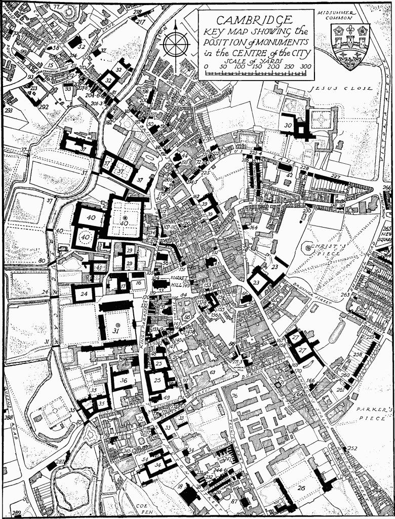
Cambridge, Key Map Showing the Position of Monuments in the Centre of the City
The much mutilated earthworks of Cambridge Castle, apparently mainly of the Norman and Civil War periods, with little of the Edwardian castle certainly distinguishable, are in poor condition. The motte is of interest for the traces of a berm below the summit perhaps marking the site of an apron-wall round the keep (see Sectional Preface p. lix).
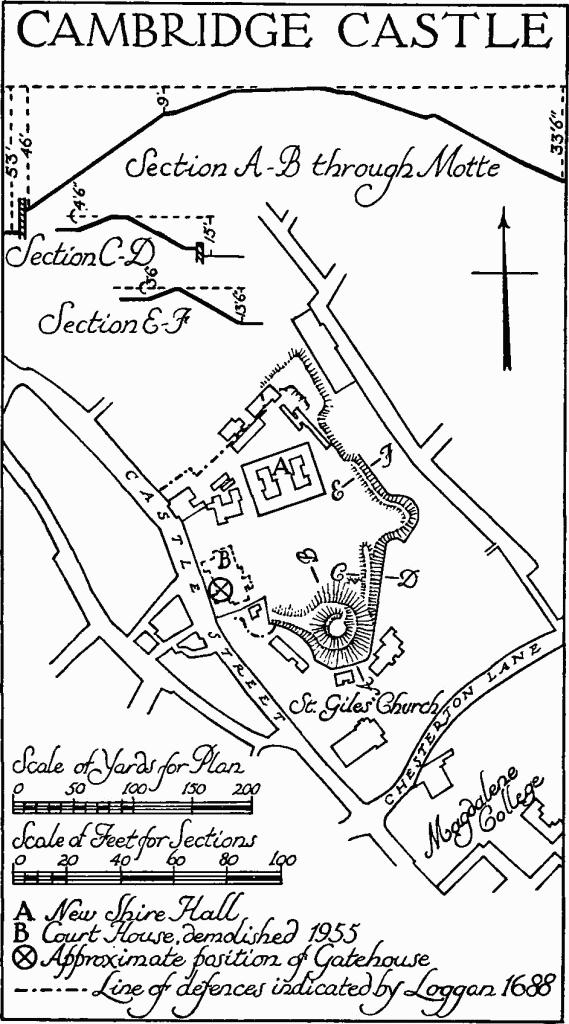
Cambridge Castle
The Motte (N.G. 44575919), a truncated cone in shape, is 200 ft. in diam. at the base, 34 ft. across the top, and rises 33 ft. above modern ground level on the N., 53 ft. on the S. The N. base is about 70 ft. above O.D. It covers some two-thirds of an acre. Paths are cut into the sides and original features are not certainly identifiable, but on the S. some 9 ft. below the top a narrow terrace begins and curves downward to the E., where it is 10 ft. wide, then rises again towards the N.; it is shown clearly as a level berm in plans and elevations of 1785 (B.M. Add. MSS. 6735, 65, 68) and indicated in Fuller's view of 1634. Leading N.E. from the motte the bank of the Bailey, 5½ ft. high on the inside, 8 ft. across the top, with a drop of 15 ft. to a modern wall on the outside, extends for some 40 yds. to where it is abruptly cut away down to the mutilated remains of the E. bastion of the Civil War defences. From the latter work a bank, 3½ ft. high inside and 4 ft. outside above the scarp of the old ditch, leads N.W. for some 40 yds.; it is then cut back. The N. bastion 50 yds. further on preserves more clearly the angularity of the Civil War earthwork, but is much cut into on the N. and W. The defences on the N.W. and S.W. are destroyed except for traces of the bailey bank branching N.W. from the motte. The total area enclosed was some 4 acres. (McKenny Hughes in C.A.S. Proc. VIII (1893), 173, and IX (1894–8), 348; W. H. St. J. Hope in ibid. XI (1905), 324; W. M. Palmer in ibid. XXVI (1923), 66, and Cambridge Castle (1928); J. W. Clark and A. Gray, Old Plans of Cambridge, 1574–1798).
The Carved Stones (Plate 28) referred to above were, except one, discovered 'under the ramparts of the bailey on the S.E. side of the gatehouse' early in the 19th century and included part of a wheel-cross head, five complete graveslabs and parts of two others, and a number of gravestones designed to stand upright. A sixth graveslab was found some yards outside the rampart. The gravestones and five slabs were lost, but drawings of them by the Rev. T. Kerrich exist (B.M. Add. MSS. 6735, 50–1, and Archaeologia XVII (1814), 228). The rest are in the Museum of Archaeology and Ethnology in Cambridge. They are of the late 10th or early 11th century and as follows: (i) wheel-cross head, diam. 14½ ins., with part of shaft, total height 17½ ins., thickness 4½ ins.; head with small central bosses, arms linked by plain ring and with marginal moulding continued down shaft, this last with interlace on front and back and key-ornament on the one surviving side; (ii) graveslab, broken across the middle, 65 ins. long, tapering from 19¼ ins. to 11½ ins. and 3 ins. to 4½ ins. thick; with symmetrical cross with U-shaped ends to longitudinal shaft, that at the head enclosing an incised cross, and four panels of interlacement; (iii) part of graveslab, 40 ins. by 18½ ins. and 4½ ins. thick; with incised wheel-headed cross and panels of interlacement flanking the shaft; (iv) part of graveslab, 31 ins. by 22 ins. and 5½ ins. thick; with upper part of cross enriched with interlacement, the ends of the horizontal arms returning vertically upwards, with interlaces on the sunk field flanking the shaft (C. Fox in C.A.S. Proc. XXIII (1920–4), 15).
(78) King's Ditch, boundary and defensive ditch to S. and E. of the old town, possibly late pre-Conquest and remodelled in the 13th century, shows only scanty surface remains. The name, loosely used in mediaeval times, by the 16th century was generally applied to the ditch shown in Richard Lyne's map of Cambridge of 1574, the course of which is traceable in the modern streetplan of the city. The ditch branched from the Cam near Mill Lane, ran along Pembroke Street, across the site of the old Botanic Gardens, where the University Laboratories now stand, along St. Tibb's Row and Hobson Street, across the Fellows' Garden of Sidney Sussex College and along Park Street to rejoin the river nearly opposite the Pepys Building of Magdalene College (Richard Lyne's map in J. W. Clark and A. Gray, Old Plans of Cambridge etc. (1921)). The ditch N. of the river is described separately below.
The only surface remains consist of a slightly sunk area in the Fellows' Garden at Sidney Sussex College W. of a scarp running S.E. from the squash court. Along Park Street a ditch was open within recoverable living memory at the end of the 19th century (C.A.S. Procs. XI, 252), though a survey of 1629 shows that the King's Ditch was then little more than a sewer, nowhere wider than 5¼ ft. nor deeper than 2½ ft. (C.A.S. Procs. XI, 251).
Knowledge of the course and nature of the work was increased in the later 19th century by observation of builders' excavations. Those for the Pitt Press extensions in 1893 revealed a substantial ditch, dated by pottery finds to the late Saxon period, that ran along the N. side of Mill Lane. Some 25 yds. N. of, and parallel to, the foregoing was another ditch at least 10 ft. deep in which mediaeval pottery was found; here no Saxon ware was recorded (C.A.S. Procs. VIII, 255; C. Fox in Prehist. Soc. of E. Anglia Procs. IV, 227–30; T. Lethbridge in V.C.H. Cambs. I (1938), 329). Further to the N.E., excavations for the University Laboratories showed only a single ditch, which appeared to be mediaeval. Probably a prolongation of this was exposed in 1892 along the W. side of Hobson Street and in this area the earlier ditch was again found, but here inside the later alignment, an opposite topographical relationship to that found in the Mill Lane area (C.A.S. Procs. VIII, 263–6).
Historically, the town was 'enclosed' in 1215 (Rot. Lit. Claus. 1204–1224 (1833), 234). In 1267 Henry III caused ditches to be made around the town, with a walk 8 ft. wide alongside (Ecclesie de Bernewelle Lib. Mem. (ed. J. W. Clark), 122; Liberate Rolls 52 Henry III, M. 6, quoted by H. Cam in C.A.S. Procs. XXXV, 49–50). The Liberate Rolls also refer to compensation for houses that were pulled down to make way for the ditch and walk. In 1268 the watercourses were ordered to be opened and the 'great ditch' cleaned (Cal. Pat. Rolls. 1266– 72, 196).
Thus the evidence, material and historical, seems to indicate that a pre-Conquest ditch was partly recut and partly superseded in the 13th century, divergences of alignment occurring demonstrably at least in the Mill Lane and Hobson Street areas.
The ditch N. of the river Cam, most often referred to as the 'ditch called Cambridge' ('le Kynges ditch' in a conveyance of 1592), now without surface remains, was possibly a stream canalised. It had an angular course; by reconstruction from the positions of narrow pieces of land belonging to the town (A. Gray in C.A.S. Procs. IX, 61) it branched from the Bin Brook S.E. of Merton Hall (Monument (103)), ran N.W. to turn sharply to the N.E. just short of the Hall, passed under Castle Street some 30 yds. S.E. of the Northampton Street junction, continued some 70 yds. into the Master's Garden of Magdalene College and then turned and passed W. of the Pepys Building of the same College to rejoin the Cam; the natural course of the stream seems to have continued E. to rejoin the river some yards further downstream (F. G. Walker in C.A.S. Procs. XV, 181–91).
The ditch has been assigned to the 7th century as affording a bridgehead for the town S. of the river (A. Gray, Dual Origin of the Town of Cambridge (1908), 14–15; H. Cam in C.A.S. Procs. XXXV, 38–9), but a date contemporary with that of the ditch S. of the river may reasonably be conjectured. About the beginning of the 13th century it seems to have been navigable as far as the church of St. Giles, then standing S.E. of the position of the present church (Monument (52)) (Ecc. de Bernewelle Lib. Mem., 98–9). It had lost significance by 1278, for then in a perambulation of the castle bounds it was called 'vetus fossatum' and crossed, not followed (ibid. 167–8; A. Gray in C.A.S. Procs. IX, 63–6).
(79) Hobson's Conduit, also known as Hobson's River and Cambridge New River, includes a fountain and culverts etc., formerly and still in part supplied by the Conduit, and bridges over this last. The fountain stands at the conduit-head by the S.E. corner of the junction of Trumpington Road and Lensfield Road; the culverts etc. above and below ground distribute fresh water from the conduit-head to different places in the old town; and the position of the bridges is given below. The proposal to flush the foul King's Ditch (Monument (78)) with water brought in from Vicar's Brook was broached in a letter of 21 Nov. 1574 from Dr. Perne, Vice-Chancellor, to Lord Burghley and in the legend on Richard Lyne's map of Cambridge of the same year in Dr. Caius' De Antiquitate. Perne's further letter of 18 Jan. 1574–5 submits practical schemes to the Chancellor (S.P., Dom., Elizabeth, 12, 103, no. 3, 1575).
The Lord of Trumpington Manor agreed to the diversion of water across the common fields by deed of 26 Oct. 1610, in which the watercourse is described as newly and lately made. This was the New River by which the water was brought from S. of Cambridge to the conduit-head and thence into the King's Ditch at the junction of Trumpington Street and Pembroke Street. A computation of levels, though necessarily approximate, seems to show that this could have scoured effectively only the westward length of the Ditch, to Mill Pit, and to explain the reason for completion, presumably before the S. range of Ivy Court of Pembroke College was begun in 1659, of a branch watercourse leading N.E. from approximately opposite the church of Little St. Mary to nearly opposite Free School Lane; the discharge of water further to the E. with increased fall may thus have been devised to scour the eastward and northward lengths of the Ditch. The N.E. branch continued to be the source of water-supply to the Old Botanic Garden until 1842.
Drinking-water was piped from the conduit-head to a new Fountain in Market Hill in 1614. The fountain was removed to the present position at the conduit-head in 1856, but the fountain that replaces it is supplied from the same source. In 1631 a third supply was drawn from the conduit-head for Emmanuel College and Christ's College; it now feeds the ponds and swimming-pools in the grounds there.
The cost of the scheme of 1610 was borne jointly by the town and the University. Thomas Hobson, carrier, (died 1630–1) and Samuel Potto (died 1632) left properties as endowments for the upkeep of the waterworks. The New River is now administered by Trustees. For a detailed history and description see W. D. Bushell, Hobson's Conduit: The New River at Cambridge, etc. (1938).
Hobson's Conduit is of much interest as an early 17th-century utility supplying water for drinking, street cleansing and scouring the drains, though now a visual rather than a practical amenity. The open runnels in Trumpington Street and St. Andrew's Street are survivals of the open watercourse. The Fountain of 1614, rather later and much simpler than that at Trinity College, is a rare and pleasing survival.
The course of the New River, culverts and pipes and the positions of the dipping-holes are described by W. D. Bushell (op. cit.); the former are indicated on the accompanying diagram. The structures only, excepting brick culverts and piping largely concealed, are described below. At the source of Vicar's Brook, 'Nine Wells', in Great Shelford parish, is an obelisk set up in 1861. As the Brook approaches Cambridge the channel has been artificially improved to a width of 13 ft. at the top, between 8 ft. and 9 ft. at water-level, and a depth of 4 ft.. About ¼ m. N. of Long Road the entirely artificial channel, the New River of c. 1610, leads off across Empty Common, under Brooklands Avenue, and alongside Trumpington Road to the conduit-head at Lensfield Road corner where is an overflow to the sewers. N. of Brooklands Avenue the channel, 20 ft. wide and 2½ ft. deep, is raised in an embankment for some 300 yds. Spillways carry surplus water to Vicar's Brook to the W. and the pond in the Botanic Garden to the E.
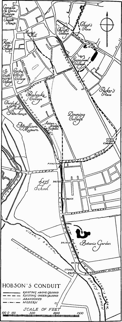
Hobson's Conduit
The Fountain is a hexagonal building (8 ft. diagonal and approx. 19 ft. high), of ashlar painted, raised on a 19th-century cast-iron platform straddling the watercourse (Plate 259). It has a high moulded plinth and a full entablature with deep frieze and elaborate pierced cresting; from behind the last rises a domical ogee roof with fir-cone finial. The sides between plinth and entablature are divided into two heights by a continuous moulded string; in the lower height is a semi-circular shell-headed niche in each face; in the upper are inscription-panels in the E. and W. faces and vents of geometrical design in the other four. The renewed, and amended, inscriptions read: (E.) 'Thomas Hobson Carrier between Cambridge and London a great Benefactore to this University Town. Died January 1st 1630 in the 86th yeare of his age'; (W.) 'This structure stood upon the Market Hill and served as a Conduit from 1614 to 1856 in which year it was re-erected on this spot by Public Subscription'. The main cresting has putti holding gilded balls at four corners, a lion and a unicorn at the others, and between them on the W. side the Hanoverian Royal arms with lion and unicorn supporters, on the other sides plain shields in strapwork framing.
N. of the conduit-head the channel as far as Addenbrooke's Hospital has been enclosed and the water piped, though part of the open channel, with modern lining, survives in the Hospital forecourt. Thence two open runnels continue down each side of Trumpington Street to the sewer by Pembroke College; they have modern stone linings, though formed from the former single watercourse probably late in the 18th century after the decision in 1789 to widen the street.
The supply to Market Hill is now piped throughout and also the more north-easterly supply as far as Emmanuel College. There the main stream is carried in a covered brick culvert into the College grounds, but surplus water is discharged into the open gutters of St. Andrew's Street and runs into the sewer by Christ's College.
Four Dipping-holes survive under paving-stones, in Regent Terrace, before Emmanuel College, in Drummer Street and at the N.E. end of Milton's Walk.
Between Brooklands Avenue and Lensfield Road are four cast-iron Bridges and the W. bank of the river is bounded by cast-iron railings. The bridge to the Botanic Garden is of a single span of about 20 ft., of flattened arch form with pierced spandrels, the University arms in the middle and the ironfounder's name and the date, Hurrell, 1850, (Swann Hurrell succeeded his uncle Charles Finch, ironfounder of Market Hill, in 1847). The cast-iron handrails have moulded standards and two plain rails to each side; on the W. are iron gates hung between the larger W. standards and flanking railings, all with spear-headed uprights. The bridge at Brooklands Lodge (Monument (20)) is similar to the foregoing but without the shields-of-arms and the gates and with the ironfounder's name and the date obscured. The two bridges N. of Bateman Street are again similar to the first, without the gates, but the date is 1851. The mid 19th-century Railings, as far as the later enclosure round the Fountain, are similar to the bridge handrails but with elbowed stays.
(80) Garret Hostel Bridge carries Garret Hostel Lane, between Trinity College and Trinity Hall, over the Cam. It is of ashlar and cast-iron. William Chadwell Mylne was the designer. Tenders were invited on 3rd July 1835 (Cambridge Chronicle), and it was built by 1837. The contract was with the Butterley Iron Company, for £960 19s. 6d. (ibid. 26 Feb. 1836). The bridge is recorded to have been rebuilt six times before, in 1591, 1626, 1646, 1769, 1814, 1821. The 1769 reconstruction was by James Essex; of brick and timber, it was known as the Mathematical bridge. Until then, Trinity Hall and the town had been responsible for upkeep, but the former paid half the cost of this reconstruction to obtain future exemption.
Garret Hostel Bridge shows a horizontal use of the Gothic idiom, with an effect of breadth and dignity.
The bridge (Plate 38) is of a single depressed four-centred span of cast-iron between ashlar-faced piers. The ramped approaches are revetted in gault brick. On each side the arch has sunk spandrels and had, until recently, a heavy archivoltmoulding with a lion's mask at the apex. The cast-iron cambered parapet is elaborated with a succession of pierced trefoiled triangles. The faces of the piers contain sunk cusped panels.
(81) Magdalene Bridge, or Great Bridge, carries Bridge Street over the Cam, immediately S.E. of Magdalene College. It is of ashlar and cast-iron and carries a plate inscribed 'Arthur Browne Archt. 1823'. Browne is said to have been the contractor and one Bevan the structural engineer (Cambridge Business Man, 7 March 1918). The main sections were cast in Derby, the rest in Cambridge. The town contributed £150 and the University £600 towards the cost of £2,350.
The crossing is of considerable antiquity (see Monument (78)). The lands listed for pontage between 1236 and 1752 show that only landowners W. of the Cam were liable for upkeep of the bridge. The mediaeval record is one of repeated dilapidations and repairs, or rebuildings. The last timber bridge was replaced in 1754 by one in stone designed by James Essex.
Magdalene Bridge is the earliest cast-iron bridge in Cambridge. It is of interest for the linear decoration deriving from the 18th-century Gothic revival.
The bridge is of a single span built up of eight longitudinal cast-iron vertical sections between ashlar abutments. The lower edges of the sections are shaped to stilted semi-ellipses, the spaces between being filled with sheet-iron to form a solid panelled soffit. To each side, the spandrels contain fan-tracery decoration and the moulding at road-level is enriched with small trefoiled arcading. The open railings have bands of quatrefoils along the foot and trefoils below the handrails; the railings on the N.E. stop against ashlar piers with sunk quatre-foiled panels on the face and surmounted by wrought-iron lamp-standards; those on the S.W., which originally stopped against adjoining houses, now end in solid iron panels.
(82) Silver Street Bridge, or Small Bridge, carries Silver Street over the Cam immediately S.W. of Queens' College. Of cast-iron, brick and stone, it was built in 1841 in replacement of one of timber described as dilapidated in the Cambridge Chronicle of 5 August 1836. The iron span was cast by Charles Finch at his Market Hill foundry (Cambridge Business Man, 7 March 1918). A panel with his name said to have been on the S. side is no longer visible. The total cost was £1,956 15s.
The bridge (Plate 38) is generally similar to Magdalene Bridge (Monument (81)) but the spandrels on both sides have ribbed panels enclosing shields-of-arms of the town supported by seahorses and with a castle above. The soffit is in six ribbed and panelled bays. Projecting upstream from the abutments are iron-faced cutwaters decorated with panels with two-centred heads. The approaches are bounded by short lengths of brick parapet-walling between pairs of stone piers; two of the S. piers support cast-iron lamp-standards. The bridge is strengthened with later iron ties.
(83) Milestones etc. are in the positions described below. From a bequest of Dr. William Mowse, Master of Trinity Hall 1552–3, supplemented by his executor Robert Hare, the latter bought the manor of Walpole as an endowment for the upkeep of highways in and about Cambridge. The estate was conveyed to the College in 1599. Within the present City, the surviving Milestones (i–iii) described below were set up under the Walpole Trust. In 1725 the first five miles along the old London Road were measured from the S.W. buttress of Great St. Mary's church by William Warren and small milestones set up; in 1726 the work was continued another five miles, and in 1727 another six to the Angel in Barkway. The total cost, with Woodward providing the stones and cutting the lettering, was £9 16s. defrayed apparently by Warren. In 1728 the first stone was replaced by Milestone (i) at a cost of £5 8s., out of the Trust fund. In 1729 the second and third stones were replaced by Milestone (ii) and (iii) of Portland stone for £2 18s. 6d. each. John Woodward seems to have been the mason again employed. In 1732 the datum mark was cut on Great St. Mary's church (see Monument (53), Miscellanea). For details of Milestones continuing beyond the City boundary, Warren's Book (ed. A. W. W. Dale, 1911), 264–8. (C.A.S. Communications IV (1876–80), 268, IX (1894–8), 304.)
Milestone (i), beside Trumpington Road opposite the junction of Brooklands Avenue, a tall rectangular stone with inset rounded head, is carved with the arms of Trinity Hall impaling Mowse (damaged), a pointing hand and the inscription in Roman capitals '1 Mile to Great Saint Maries Church Cambridge', 'A D' with an illegible date [1728]. 'Cambridge' has been obliterated and recut. Milestone (ii), beside Trumpington Road approx. 715 yds. N.E. of Trumpington church, retains traces only of a shield of the arms of Trinity Hall; it was dated 1729. Milestone (iii), beside the Hauxton Road approx. 1050 yds. S. of Trumpington church, is similar to (i) but with a shield of the arms of Trinity Hall and marking the third mile; the date [1729] is buried.
Stone Wall-tablets, two, set one above another in the streetfront of no. 8 Castle Street, are inscribed 'Godmanchester Turnpike Road ends here' with an arrow, and 'To the Horseshoe Corner Godmanchester 14 miles', late 18th or early 19th-century.
Court House, see Monument (77).
(84) Guildhall stands on the S. side of Market Hill. It is a building of 1936–7, but reset in the wall on the first floor of the E. wing is the foundation-stone of the Guildhall previously on the site found during the excavations for the new foundations.
The Corporation insignia, plate and chest are described below together with the weights and measures kept here, at the Weights and Measures Office, and at the Folk Museum.
The Foundation-stone is tall and narrow and inscribed with a long Latin inscription, 'Faxit Deus haec nova Gilda Aula Communitatis Villae Cantabrigiae, in ipsissimo Loco veteris jam periclitantis et ruinosae, posita', etc., the date 1782 and the name of the architect, James Essex.
Corporation insignia and plate etc. (Plate 45): (i) Great Mace, 4½ ft. long, given by Samuel Shepheard of Exning, M.P., in 1710; silver-gilt, with assay-mark for 1710, maker's mark PY; of normal mace form with close-crowned bowl-shaped head, pierced scroll-work terminal figures linking the last to the first knop on the shaft, middle knop and shaped knop at end; embossed decoration on the head including the crowned arms of Queen Anne with lion and unicorn supporters and the initials A R and, round the sides, crowned rose, thistle, fleur-de-lys and harp and the arms of the town, all alternating with terminal figures flanked by the initials A and R; knops with embossed acanthus decoration; see (vii) below. (ii–v) Maces, set of four, 3½ ft. long, with assay-mark for 1723, maker's mark crowned P; all alike and generally similar to (i) but with the arms of George I and initials G. and R. and the end knops shaped to include two cartouches, one inscribed 'The Gift of Tho. Bacon Esq. Tho. Nutting Mayor 1724', the other with the arms of Bacon. (vi) Mace, 10½ ins. long, of copper-gilt, c. 1630; open-crowned bowl-shaped head, the top missing and the crown much damaged, divided by moulded ribs into four panels containing respectively the initials C and R, a crown and a rose modelled in relief; the shaft divided into four lengths by moulded bands; the flanges of pierced card-cut scroll-work, one broken. (vii) Mace-rest for (i) above, 1 ft. 10½ ins. tall, silver-gilt and bronze; with assay-mark for 1710, maker's mark a circle of five pellets, crowned and with P Y below; plate, with U-shaped top and embossed with an achievement of the arms of Queen Anne, mounted on a turned bronze stem with cylindrical end to fit in a socket; with red cords with two large and two small tassels knotted to the stem. (viii) Tankard, 10 ins. high, with assay-mark for 1762 and maker's mark C T W W in a circle; shaped bowl and lid with scrolled handle and pierced thumbpiece; engraved by W. Stephens with the achievement-of-arms of the town and a list of the donors, 1763. (ix) Coffeepot, 10¾ ins. high, silver, with gadrooning, engraved with the achievement-of-arms of the town and the arms of Halsted and inscribed 'Gift of Thomas Halsted Esq. Mayor in 1767 Elected Alderman 1765 resigned 1775'. (x) Beaker, 47/8 ins. high, with assay-mark for 1762, maker's mark JS; with nearly straight sides and moulded foot, engraved with the arms of the town and of Purchas and inscribed 'Gift of John Purchas Alderman Sept. 29 1759'. (xi) Beaker, 3¾ ins. high, otherwise similar to (x) but with the arms of Norfolk impaling Spencer and inscribed 'Gift of Wm. Norfolk Alderman Aug. 16 1759', with scratching beneath 'the cup and all the stoyps were e[n]graved by W. Stephens 1762'. (xii–xix) Salts, set of eight, 2¼ ins. high with assay-marks for 1764; with shallow rounded bowl on moulded stem and flared moulded foot; six given by Alderman James Burleigh, 1764, two by William Mott, 1764. (xx–xxvii) Spoons, set of eight, 85/8 ins. long, with assay-marks for 1799; plain, inscribed 'Cambridge Corporation'. (xxviii– xxix) Spoons, two, generally similar to the foregoing but marks illegible; inscribed 'Gift of John Newling Alderman, Jan. 11 1763' and 'G. W. Hattersley 1915'. (xxx–xxxi) Spoons, two, generally similar to the foregoing but with assay-marks for 1813, given by Edward Goode.
Spear, 5 ft. 3¾ ins. long, with iron head and wood shaft with much-worn painting of the arms perhaps of Queen Anne and of the town and illegible inscription. Staff, 5 ft. 6½ ins. long, of wood painted with the arms of Queen Victoria and of the town, 'Rd. Foster Esq. Mayor' and '1839'; others in the Folk Museum are in better preservation. Halberds, pair, with pierced blades, tassels, and polished wood shafts, perhaps 17th-century.
Chest (Plate 46), of oak, 5¾ ft. by 2¼ ft. by 2½ ft. high, covered with sheet-iron, repaired, and iron-bound, the lid in two halves with two locks and hasps and eight hasps for locking-bars. Probably the new chest for the charters etc. made by Otte in 1531; 3 cwt. of iron, eleven iron plates and a thousand nails cost £1 9s. 4d. The total cost was £10 10s. 4d., which included carriage to London and back. (Cambridge Borough Docs. I (ed. W. M. Palmer, 1931) xlii).
Weights and Measure Standards: (i) Bushel Measure, of bronze, 10½ ins. high over all, 1 ft. 6¾ ins. internal diam., 81/8 ins. internal depth, weight 69½ lbs., straight sided, with two facetted handles, three feet and band of lettering in Roman capitals with the name and titles of Queen Elizabeth interspersed with crowned initials E R, rose, portcullis, fleur-delys, and date 1601. (ii) Gallon Measure, of bell-metal, 75/8 ins. high, 17 ins. internal diam., 8¼ internal depth, with one handle, engraved with the achievements of the Stuart Royal arms and the town, 1646. (iii) Set of CupWeights, 4 lb. to two 1 drams, fitting one inside another, the largest with a lid engraved with the arms of the University, 1822. (iv) Set of Winchester Measures, of bronze, ½ bushel, peck, ½ and ¼ peck, quart, the first three each with two handles, engraved 'University of Cambridge 1823'. (v) Imperial standard Yard and Bed, engraved 'University of Cambridge 1824', by Bate. All the foregoing Standards are obsolete. (vi) Set of Measures, gunmetal, bushel to ½ gill, the first seven with handles, and engraved with the University arms and 'University of Cambridge 1824'; the three small Measures engraved only with 'University of Cambridge 1824'. (vii) Set of spherical Weights, brass, 56 lb. to ½ dram, seven of the large weights engraved 'University of Cambridge 1824', by Bate. All the Standards in (vi) and (vii) are marked with Exchequer marks and Board of Trade Standards Department marks. They are still used by the city as local standards.
(85) Railway Station stands just over 1 mile S.E. of Great St. Mary's. It is of one and two storeys. The walls are of gault brick with stone and stucco dressings; the roofs are slate-covered. Originally the Eastern Counties Railway Station, it was designed by Sancton Wood and opened on 29 July 1845. The building was then symmetrical on plan and in elevation; an open-arcaded way on the E. matched that which survives on the W. and trains drew up in the former, vehicles in the latter (Railway Chronicle, 2 Aug. 1845, with sketch). To supplement the single narrow platform, about 1850 a timber island-platform reached by bridge and subway was added on the E. This was removed in 1863 and the E. arcaded way demolished to give the necessary space for the present scheme of a single wide platform with N. and S. train-bays; at the same time offices were added N. and S. of the building that remained (Cambridge Chronicle, 21 Nov. 1863). In 1893, with the removal of the Newmarket line take-off to Coldham's Lane, the platform was lengthened; it was lengthened again in 1908, to 1,515 ft., and again subsequently to 1,650 ft. In 1908 also more offices were added, partly in the S. end of the W. arcaded way. Encroachment upon this last has continued; the booking-hall etc. now occupies the whole of the five middle bays and a bicycle-store the four S. bays.
The Station is of interest as an early railway building and notable for the application of an Italianate style to new and entirely functional architectural requirements, with original and distinctive result.
The W. front of the original station (Plate 298) contains a continuous arcade from end to end and has a heavy unbroken crowning entablature; the roof does not show. The arcade consists of fifteen round-headed arches, all originally open, with square brick piers, moulded plinths, imposts and archivolts. The four N. bays remain unaltered, with dwarf walls from pier to pier. The entablature has an architrave enriched with small plain roundels and a frieze with raised metopes alternating with shaped brackets under the wide overhang of the cornice. In the spandrels between arcade and entablature are original roundels containing modelled and painted arms, from the N., of St. Catharine's and King's Colleges, Trinity Hall, Pembroke College, Peterhouse, Cambridge town, Osborne quartering Godolphin for Francis Osborne, 7th Duke of Leeds (High Steward of Cambridge), Charles Philip Yorke, 4th Earl of Hardwicke (Lord Lieutenant), Percy quartering Lucy for Hugh, 3rd Duke of Northumberland (Chancellor), Lord Lyndhurst (High Steward of the University), the University, Clare, Gonville and Caius, Corpus Christi and Queens' Colleges. Behind the arcade part of the original back-wall remains. On the ground floor the four N. bays have round windows; on the first floor are sash-hung windows in the five bays towards each end; all have stucco architraves. In the fifth and eleventh bays are open luggage-entrances with cornices.
The N. end has an archway to the W. returned from the arches on the W. front, but rather larger, for the passage of vehicles, with continuous moulded imposts and flanked on the E. by a small plain archway for foot-passengers. Close E. of the latter is the addition of 1863 with the wall rising to the height of, and capped by, a return of the impost-mouldings just described. The same arrangement, reversed, of archways was repeated originally on the E., for trains and foot-passengers; both these arches have been destroyed, but a large panel with stucco frame remains in the wall-space above impost-level flanked now only by the large W. arch. The main entablature is returned from the W. front. The roundels, as before, contain the arms of Magdalene and Christ's Colleges.
The S. end is identical in arrangement with the N. end, but the large W. archway is blocked to the springing and the small W. archway covered by later additions. The arms are of Jesus and St. John's Colleges.
The E. side comprises the back wall of the former E. arcaded way. On the ground floor are square-headed doorways and sash-hung windows, all with stucco architraves and cornices and with the window-sills continued as plat-bands; some have been blocked, altered or removed. The same design is continued across the extensions of 1863. The first floor was remodelled in the same year.
(86) Public Library, in Wheeler Street, between the Guildhall and Peas Hill, is a late 19th-century building. Reset in the Central Junior Library is a fireplace formerly in the house of John Veysy, which stood at the corner of Petty Cury and Market Hill. A second fireplace from the same place at Madingley Hall is dated 1538 and has the arms of the Grocers' Company.
The fireplace is of clunch with stop-moulded jambs and four-centred arch in a square head. The inner mouldings are enriched with carved paterae, the initials H V and a lion's mask, the outer with paterae, 'K Veysy' and 'Veysy' thrice, and the spandrels with a bird and the initial V in one, stylised foliage in the other. Over the arch is a crested frieze of tracery panels, partly defaced, with the monograms IV and KV. Early to mid 16th-century.
(87) Addenbrooke's Hospital stands on the E. side of Trumpington Street, E. of the Fitzwilliam Museum. Part of the original building of 1740 survives incorporated in the 19th-century and modern extensions of the Hospital. John Addenbrooke (died 1719) left £4,500 to found a hospital; land was bought in 1728 and building began twelve years later. In 1766 the hospital was transferred from the Trustees to a Court of Governors. A colonnade across the front and two wings designed by Charles Humfrey and in part paid for by John Bowtell were completed by 1825 at a cost of over £4,000 (Cambridge Chronicle 9 May, 26 Sept., 10 Oct. 1823, 7 Jan. 1825). The hospital at this stage is shown in C. H. Cooper, Memorials of Cambridge III, pl. facing p. 149.
In 1833 tenders were invited for two additional wards designed by Mr. Walter, architect to the hospital (Camb. Chronicle 17 April, 3 May, 4 Oct. 1833). Unspecified new buildings were completed in 1845 (ibid. 4 Jan.). In 1863 Matthew Digby Wyatt, in competition with A. Salvin, P. C. Hardwick and W. M. Fawcett, was appointed the architect for extensive alterations. For reasons of economy he proposed to make maximum use of the existing buildings and replied to charges of ugliness in his designs that he would be delighted to remedy it 'at an extra cost of from one to several thousand pounds according to the style adopted and the materials I might be permitted to make use of'. The building committee rejected a proposal to demolish all the old buildings and Wyatt then worked up a plan proposed by Dr. Humphry, one of the surgeons, for extending and heightening them; he prepared alternative designs for the elevations from which the committee made their selection in December 1863. Tenders for the works were invited and in May 1864 the contract was let to Messrs. Thoday & Clayton for £10,975. The work was finished in 1866. Further extensive additions have since been made. See also No. 13 Fitzwilliam Street (Monument (245)).
The fragmentary and much-altered original buildings of Addenbrooke's Hospital surviving are of little architectural significance; interest lies in their connection with a forerunner of those acts of private munificence that created and maintained the voluntary hospital movement.
Architectural Description—The surviving walls of the Hospital of 1740, of two storeys with a basement, form the rectangular block close behind the present main entrance. The front wall has been removed down to ground-floor level. The E., N. and S. walls are of red brickwork, the first being divided into three bays and with the middle bay projecting 9 ins.; the ground floor of the S. bay has been cut away. The original windows are sash-hung, except the two small round windows towards the E. end of the S. wall. Two walls, probably original, running E. and W. divide the interior equally into three; for the rest, no evidence of the internal arrangement survives; the staircase in the middle is modern. Two short cross-walls some 14½ ft. to N. and S. of this original block are perhaps remnants of the S. and N. walls respectively of the wings of 1823–5.
The W. Entrance-gates with short lengths of railing to each side are of scrolled and foliated wrought-iron and flanked by rusticated stone piers with cornices; extending thence to similar piers at the N. and S. ends of the street front are iron railings with standards with turned finials. All are of the 18th century.
The N. Boundary-wall of the site is of brick. It is of the 16th and 17th centuries, repaired and patched. Part is concealed by later sheds, part incorporated in the N. wall of the John Bonnett Memorial Laboratories and part, reduced to a dwarf wall, stands free behind the staff hostel in Fitzwilliam Street.