An Inventory of the Historical Monuments in the County of Cambridgeshire, Volume 1, West Cambridgshire. Originally published by Her Majesty's Stationery Office, London, 1968.
This free content was digitised by double rekeying. All rights reserved.
'Arrington', in An Inventory of the Historical Monuments in the County of Cambridgeshire, Volume 1, West Cambridgshire(London, 1968), British History Online https://www.british-history.ac.uk/rchme/cambs/vol1/pp1-4 [accessed 30 April 2025].
'Arrington', in An Inventory of the Historical Monuments in the County of Cambridgeshire, Volume 1, West Cambridgshire(London, 1968), British History Online, accessed April 30, 2025, https://www.british-history.ac.uk/rchme/cambs/vol1/pp1-4.
"Arrington". An Inventory of the Historical Monuments in the County of Cambridgeshire, Volume 1, West Cambridgshire. (London, 1968), British History Online. Web. 30 April 2025. https://www.british-history.ac.uk/rchme/cambs/vol1/pp1-4.
In this section
AN INVENTORY OF THE ANCIENT AND HISTORICAL MONUMENTS IN WEST CAMBRIDGESHIRE
Arranged alphabetically by Parishes
National Grid references are given for all monuments except those buildings which are shown on the parish maps and plans; a map of the whole area is in the pocket inside the back cover. A superior letter before a monument number refers to the sheet number in the O.S. 6 ins. map series as listed at the head of the parish. The village plans have been taken from the available sheets of the O.S. 25 ins. maps which have not been revised for modern detail.
Churches are normally described in the order E. to W. and N. to S., repetitive features such as arcades and windows being numbered in the same order. For monuments not readily orientated to a cardinal point a conventional N. point has sometimes been assumed. All construction since 1850 is termed modern. Church plate is of silver unless otherwise described. Dates in the descriptions of memorials are those of the deaths of the persons commemorated, as recorded; surnames in brackets are maiden names. Numbers following unidentified shields of arms refer to their blazons, which are listed at the end of the Armorial. The Class references in the accounts of certain monuments are designed to avoid repetitive descriptions; the Classes are explained in the Sectional Preface (Houses p. xlvi; Moats p. lxi).
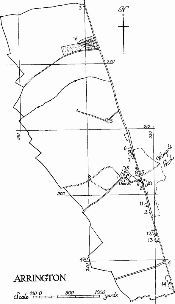
1 ARRINGTON
(O.S. 6 ins. aTL 35 S.W., bTL 34 N.W.)
Arrington is a village and parish 10 m. W.S.W. of Cambridge. The parish, which is 1407 acres in extent, forms an oblong on the W. side of Ermine Street, save for a small enclave to the E. of the road opposite the church, and lies across a poorly defined escarpment. The N. part is on chalk, here covered by boulder clay forming a broad plateau rising to more than 250 ft. above O.D. The rest of the parish, S. of the chalk scarp is on gault, and extends to the river Rhee at c. 70 ft. above O.D. which forms its S. boundary. Drainage is S. to the Rhee and E. to its Wimpole tributary.
The original settlement of Arrington lay on the spring-line at the foot of the scarp around the church, but later development has tended to take place along the S. section of Ermine Street.
The 13th-century church with its aisled nave suggests at least an average population for the time but its subsequent history points to a decline in the later middle ages. The parish was probably enclosed by the Chicheleys in the 17th century (see Monument (17)). It remained part of the Wimpole estate until the latter was broken up between 1891 and 1934.
The bulk of the listed houses are of the 18th and 19th centuries and in terrace or semi-terrace form (Monuments (7–9) and (11–13)). The few single houses built after 1715 and not listed include one or two comparatively late instances of internal-chimney design.
Ecclesiastical
a(1) Parish Church of St. Nicholas stands on rising ground to the W. of the modern village at the S. end of an oblong platform occupied by the churchyard. The walls are of clunch, in part squared and coursed, local field stones and red brick. The main roof, now tiled, was originally thatched and probably continued to be so until comparatively recent times. A return of 1593 (Bodleian MS., Gough, Ecc. Top. 3, 61) states 'oure chyrche lacketh coveryng with rede and be cause ye tyme ys so shorte we have not as yet fenessheyd yt but we wyll as shorkly as may be god wyllyng'. The timber spire is lead-covered.
There is no reason to place any part of the fabric earlier than the mid 13th century; and the church, consisting of a long Chancel, Nave (originally with aisles) and West Tower seems to have been completed, with the possible exception of the aisles, by or soon after 1300. In the 16th or early 17th century the aisles, which had been completed or rebuilt later in the middle ages, were taken down and the arcades filled in with brick, five windows and the S. doorway being reset in the blockings. About the same time the top stage of the tower was rebuilt or added, and it was again rebuilt in the 18th century. The church has a modern S. porch and a modern vestry to the N. of the tower. It was restored in 1894.
Arrington
Architectural Description—The Chancel and Nave (60 ft. by 17 ft.) are structurally undivided. The Chancel has a 13th-century E. window of three uncusped lights with intersecting tracery and external and internal labels, the last with mask stops. The E. angles are each supported by chamfered angle buttresses which are of a single stage and have a moulded string beneath weathered copings. In the N. wall are two two-light windows similar in character and date to the E. window but without labels; there are two windows in the S. wall resembling those in the N. wall. All five are much decayed externally and there are some modern repairs. Between the two S. windows is the blocked 13th-century S. doorway. Externally the blocking has obliterated the jambs but part of the moulded head remains; inside, the splays and depressed rear arch are original. At the extreme W. end of the S. wall of the chancel is a blocked rectangular 'low-side' window.
The Nave (Plate 11) has a blocked mid 13th-century N. arcade of three arches, each apparently of two orders, but only the outer order on the nave side is visible. It is hollow-chamfered with broach and other stops. The octagonal piers and responds with moulded caps and bases are mutilated and the profiles are badly worn; internally all except the E. respond, which masks them, have been cut back below the caps flush with the blocking externally. Beneath each arch is a reset window of c. 1400 of two cinque-foiled lights with pierced four-centred head. The S. arcade resembles the N. arcade but the outer orders of the arches are plain chamfered; the arcade has been likewise blocked and the piers cut back internally; externally the outer orders together with the caps and the tops of the piers are exposed. In the blocking under the first arch is a reset early 14th-century window of two trefoiled lights with net tracery. It is moulded externally but the mouldings are much eroded. Under the second arch is a reset 13th-century doorway of two continuous chamfered orders; the inner order has been replaced inside out so that the door opens into the porch. Under the third arch is a window of c. 1400, also reset; it is of two cinque-foiled lights with a quatrefoil in a four-centred head.
The West Tower (9½ ft. square) was built c. 1300 and is of three stages. The lower stages, which are of field stones with clunch dressings, though much patched, are original; the belfry, of red brick with stone quoins and embattled parapet, together with the short lead-covered octagonal spire, has been rebuilt in the 18th century. The depressed tower arch, of two chamfered orders rising off the side walls, is original. The W. window of two uncusped lights with a pierced head has been restored externally, but the splays and rear arch are original. Pairs of buttresses at the W. angles of the tower rise in two heights to the bottom of the belfry. The belfry has a window in each face, of two lights in a four-centred head, 16th-century, reset and much worn.
The Roof over the nave and chancel is continuous. It is of trussed-rafter type, ceiled on the underside and inaccessible from above, and may be mediaeval. The four tie beams are additions. An original weathercourse on the E. face of the tower corresponds to this roof but is placed somewhat above the tiles and would be appropriate for thatch.
Fittings—Bell: inscribed in black-letter 'John: dier: made: me: 1583'. Bell frame: old, remodelled in 18th century. Font: limestone, consisting of a tub-shaped bowl with a roll mould at the foot, 12th- or 13th-century, and a later mediaeval stem with foot-pace cut back, restored. Floor slabs: in chancel (1) of John Wragg, 178[3]; (2) of Elizabeth, wife of John Wragg, 1774. Organ: in gothic case; mid 19th-century. Piscina (Plate 6): double with two octofoil drains beneath a moulded round arch rising from responds consisting of attached shafts with moulded caps and bases; the arch is intersected by two uniform half arches, which presumably sprang from a central shaft, now missing; the whole is set in a rectangular moulded frame; 13th-century. Plate: includes an inscribed cup and a cover paten, both by Thomas Buttell and dated '1569'; and two pewter plates. Miscellaneous: over S. doorway, on the inside, late mediaeval wooden boss carved as a mermaid; in tower, two similar moulded octagonal stone bases for octagonal shafts of 3 ins. and 3½ ins. diameter, possibly mediaeval; immediately E. of piscina, rounded corbel, mediaeval.
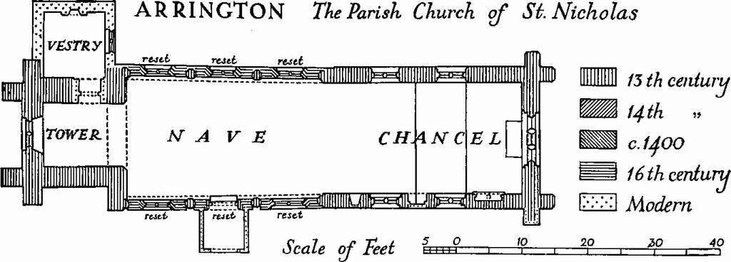
Arrington, the Parish Church of St. Nicholas
Secular
b(2) Milestone, the 44th from Shoreditch church, limestone, 13 ins. square, stop-chamfered with bull-nosed top, inscribed 'ARRINGTON/LONDON/44/ROYSTON/6/CAXTON/6'; 18th- or early 19th-century.
a(3) Milestone, the 46th from Shoreditch church, similar to the foregoing but mutilated, inscribed 'A/LONDON/46/ROYSTON/ 8/CAXTON/4'.
b(4) Toll House, one storey, gault brick, and slated roof; c. 1825.
a(5) Arrington Mill, tower windmill of white brick; only two stages remain; first half of 19th century.
a(6) Wragg's Farm consists of a house and buildings. The House, a long range of two storeys with an internal chimney, walls partly framed and partly of brick, tiled roof, is of the 17th and 18th centuries. The Buildings, grouped around a yard to the N., include a framed and boarded barn of four bays and two aisles with a half-hipped roof; and a granary standing on stone stilts in the yard, also framed and boarded, with tiled pyramidal roof rising to a small finial; both 18th-century. A boundary wall between the farm buildings and the road is of locally made hollow bricks (1 ft. by 6 ins. by 4½ ins.); first half of the 19th century.
a(7) Houses, eight dwellings of one and two storeys forming a group composed of a range of seven and one outlier to the N.; 18th- and 19th-century. The six S. dwellings form a symmetrically designed block. The materials are plastered studwork and clay bat with thatched roofs.
a(8) Almshouses (Plate 45), six, of red brick with stone dressings, in the Tudor manner. They consist of a one-storey range fronting the road and two-storey wings projecting to the E., with central porch and subsidiary porches in the angles. Erected to the designs of H. E. Kendall in 1846 by Susan, fourth Countess of Hardwicke, in memory of her mother.
a(9) Houses, group of three similar 18th-century dwellings of two storeys and attics. The walls are of red brick with lath and plaster at the rear; the roofs are hipped and covered with tiles. The houses are planned in depth with back rooms in outshuts, above which rise hipped staircase projections. The N. house is separated from the others, which are semi-detached, by a carriage entrance, now built up, and is to a superior specification. The S. house has an end room on the ground floor apparently designed for a shop or office. The fronts have been much altered and there are a number of additions, but the group is of interest as an example of urban lay-out in a rural setting.
a(10) The Hardwicke Arms, inn, a range flanking the road, predominantly of two storeys in brick and tile, is of various dates in the 18th century; some work was done by Soane between 1791 and 1794 (account book, 'The Earl of Hardwicke', 52 and 88, in Soane's Museum). Parallel at the rear was a second range, of stables and outbuildings, part of which has recently been demolished.
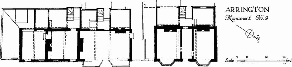
Arrington, Monument No. 9
b(11) Range (Plate 30), of three dwellings, at right angles to the road, of one storey with attics; mainly of plastered studwork with thatched and tiled roofs, dormered, and half-hipped at the ends. The two E. dwellings originated as a 17th-century house (Class J). Parts of the frame of this last are exposed, including stop-chamfered beams. The remainder is 18th-century and later.
b(12) Range (Plate 34), six dwellings, two-storeyed, of clay bat and studwork with thatched roof hipped at the ends, c. 1830. The dwellings are uniform: each has two sliding-sash windows on either floor E. to the road and central front door; at the back is a continuous lean-to, somewhat altered.
b(13) Range, four dwellings, set back along the W. side of the road, to a symmetrical design; of plastered studwork with gable-ended roof, partly thatched and partly slated. It is of late 18th- or 19th-century origin; a parallel range in white brick has been added on the E.
b(14) Bridge Farm, house, a N. and S. range of two storeys with attic, framed and plastered, with a chimney slightly off centre; late 17th-century with additions.
a(15) Gateway to Wimpole Hall—see Wimpole (2).
Earthworks
a(16) Decoy pond (N.G. TL 320524), possibly former water supply for Wimpole Hall—see Wimpole (2).
(17) Cultivation Remains (not on O.S.). Ridge and furrow survives as earthworks in two places (around N.G. TL 325506 and 330485). In the latter area the ridges are 160 yds. to 270 yds. long, 6 yds. to 11 yds. wide and 6 ins. to 9 ins. high with headlands 5 yds. wide. Both are in old enclosures.
Traces of ploughed-out ridge and furrow are also visible on air photographs in the S. of the parish, mostly running N.W. and S.E. across the contours; many of these fit into the existing rectangular fields, which suggests that this ridge and furrow was due to ploughing after enclosure. In the N. of the parish further traces (especially around N.G. TL 321517), including curved field boundaries, seem to be those of pre-enclosure strips in curving furlongs otherwise unrelated to the present field pattern.
In 1546 strips are described as being in 'High Field' and 'Low Field', but Arrington, like the adjacent parishes, had been enclosed by 1700.
(Ref: terrier of 1546 in Gape papers (C.R.O.); map of 1828 (C.U.L.); tithe map 1837 (T.R.C.); air photographs: 106G/ UK/1635/3492–5; CPE/UK/2024/3055–7.)