An Inventory of the Historical Monuments in the County of Cambridgeshire, Volume 2, North-East Cambridgeshire. Originally published by Her Majesty's Stationery Office, London, 1972.
This free content was digitised by double rekeying. All rights reserved.
'Appendix: The Devil's Dyke and Fleam Dyke', in An Inventory of the Historical Monuments in the County of Cambridgeshire, Volume 2, North-East Cambridgeshire(London, 1972), British History Online https://www.british-history.ac.uk/rchme/cambs/vol2/pp139-147 [accessed 30 April 2025].
'Appendix: The Devil's Dyke and Fleam Dyke', in An Inventory of the Historical Monuments in the County of Cambridgeshire, Volume 2, North-East Cambridgeshire(London, 1972), British History Online, accessed April 30, 2025, https://www.british-history.ac.uk/rchme/cambs/vol2/pp139-147.
"Appendix: The Devil's Dyke and Fleam Dyke". An Inventory of the Historical Monuments in the County of Cambridgeshire, Volume 2, North-East Cambridgeshire. (London, 1972), British History Online. Web. 30 April 2025. https://www.british-history.ac.uk/rchme/cambs/vol2/pp139-147.
In this section
APPENDIX
THE DEVIL'S DYKE AND FLEAM DYKE (Northern Section)
Of the many linear earthworks or dykes in East Anglia, two exist in the general area under consideration: the Devil's Dyke and Fleam Dyke. The Devil's Dyke stretches beyond the parochial limits of the Inventory but it has been described in its entirety. The northern section of Fleam Dyke lies totally within Fen Ditton parish; the southern section, although in Cambridgeshire, is associated with the northern by name only and has consequently been omitted from the detailed description. A summary of theories which have been advanced in connection with the date and function of these earthworks is included at the end of the descriptions.
The Devil's Dyke (Fig. 124; Frontispiece)
Introduction
The Devil's Dyke, of which the N.W. half lies within the area, is a massive linear defensive earthwork 7½ miles long running N.W.-S.E. comprising a large bank with a deep ditch on its S.W. side. It extends from the edge of the fens at the village of Reach to the upland area of south-east Cambridgeshire near Wood Ditton. It lies almost entirely upon chalk which slopes generally N.W. between 350 ft. and 10 ft. above O.D. Apart from a number of gaps for roads and railways and the destruction of its extreme N.W. end, it is in good condition. It was excavated in 1923–4 by Sir Cyril Fox. Its date and precise purpose remain unknown.
Siting
Strategically the Devil's Dyke crosses the chalklands of south-east Cambridgeshire, along which passed the ancient Icknield Way. It runs between the fens and the formerly forested boulder clay area of Suffolk and Essex and consequently prevented access into East Anglia by this natural routeway; its siting however is the result of a wider defensive plan. At its N.W. end it meets the fen at Reach which is sited on a bulb-shaped promontory (Frontispiece). The fact that it was deliberately positioned to extend on to this promontory suggests that it was intended to meet the S.E. end of Reach Lode (Swaffham Prior (74)) already in existence. Reduction in its length would have been possible if it had terminated at the fen edge half a mile to the S.W., or to the N.E., of its present position; similarly a saving of over two miles would have been made if it had been sited 1¾ miles to the S.W. (i.e. between Dullingham and Swaffham Bulbeck villages). As a result of its greater length a continuous line of defence 10 miles long from the forest in the S.E. to the River Cam in the N.W. was achieved.
Description
The Dyke consists of a massive bank, usually 12 ft. to 18 ft. high above the adjacent ground level, and up to 70 ft. wide with a large ditch up to 17 ft. deep and 65 ft. wide on its S.W. side. Except for the destroyed N.W. end it maintains its dimensions throughout its length. Minor alterations in its form have taken place resulting from digging into the bank for road metal, ploughing the ditches and natural slumping of the bank and ditch sides, but some variations in the profiles of both bank and ditch cannot be explained by later alterations whether natural or man-made. Particularly noticeable is the shape of the bank which varies between a narrow spine-shaped crest only 3 ft. or 4 ft. wide to a broad flat-topped summit up to 18 ft. across. Likewise the ditch varies between well-defined V-shape with its bottom only 2 ft. to 3 ft. wide, and a broad flatbottomed ditch up to 18 ft. across. These variations often occur within a few yards of each other and may be connected with the method of construction employed by different gangs of workers.
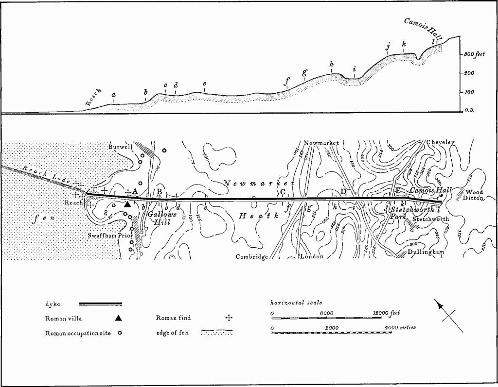
Fig. 124 The Devil's Dyke
Plan and exaggerated longitudinal Profile
In general terms the Dyke is laid out in three major alignments. The central and longest section (Fig. 124, c to k), some 5 miles in length from Gallows Hill to Stetchworth Park, is approximately straight and orientated 133° E. of N. As Sir Cyril Fox pointed out, this is almost certainly because the two end points of this alignment are intervisible and thus the intermediate section could be laid out in a straight line; however, the two shorter end-sections are both deflected slightly from this main alignment. At the N.W. end the section from Gallows Hill to Reach village (Fig. 124, d to a; Plate 1), 1½ miles long, turns northwards by 5° (138° E. of N.), while at the S.E. end the section from Stetchworth Park to Camois Hall, Wood Ditton (Fig. 124, k to l), 1 mile long, veers slightly southwards (141° E. of N.). Fox suggested that both these deflections were caused by the fact that the extreme ends were not visible from the main sighting points and therefore had been incorrectly aligned. However it is more probable that the deflection of the S.E. section was imposed upon the builders of the Dyke for topographical reasons, particularly the existence of a broad dry valley known as Dane Bottom, orientated N.N.W.-S.S.E., E. of Stetchworth Park. If the Dyke had continued on its main alignment it would have cut across the S.W. side of this valley in such a way that the bank would have been dominated from the land to the S.W. To retain some tactical control the Dyke had to be curved slightly to remain on the edge of the valley's side. The deflection of the Dyke at its N.W. end also appears to be for tactical reasons. Again, had the main alignment been continued the Dyke would have reached the edge of the fen 350 yds. S.E. of the end of Reach Lode; its termination at the end of the Lode was clearly intentional. On the other hand, if the whole Dyke had been aligned on Reach Lode it would have then passed to the N.E. of Gallows Hill which would have dominated it; in this event the Hill, the highest point hereabouts, could not have served as a sighting point for setting out the Dyke.
Although these deviations are the largest in the alignment there are nine minor changes not hitherto recognised owing to the density of modern vegetation. The most obvious is on Newmarket Heath (Plate 1) just N.W. of the London road (A 11) gap where a variation in direction is visible (Fig. 124, f). Although most of these changes involve no more than one or two degrees the effect on the plan of an earthwork of this length is considerable. The changes occur in the sides or bottoms of valleys thus indicating the difficulty in keeping alignments straight where there is dead ground between the main sighting points.
There are 16 gaps of various forms and dates through the Dyke. They include two cut for railways in the 19th century, four for roads, a number for footpaths and one apparently for a watercourse. Fox was of the opinion that none of the gaps was original and that the Dyke was designed to block the whole chalk zone. He reserved judgement on the presumed line of the Icknield Way, now the London road (A 11) across Newmarket Heath. Broadly, his statement can be accepted, although certain additional points may be noted. A change in alignment at the London Road Gap (Fig. 124, g) of about 2° might suggest an original opening, but the Dyke is so mutilated for a distance of nearly 250 yds. that there can be no certainty in the matter. There is another change in alignment of ½° at the point where the Dullingham–Newmarket road crosses the Dyke (Fig. 124, i), but the bank to the S.E. of the road would, if projected, be about 30 ft. to the N.E. of that on the N.W. of the road. At this point the Dyke is in a broad valley, draining W., in the bottom of which runs the road and a chalk stream which has a considerable flow in winter and wet weather. Possible reasons for this change in alignment are that the Dyke is in dead ground from the sighting points, or that the stream influenced its position, or that the gap is an original feature.
The N.W. end of the Devil's Dyke is on the edge of the fens where Reach village meets Reach Lode. The Dyke rises rapidly from 10 ft. to 50 ft. above O.D. (TL 56556633). Owing to alterations to the Lode and the construction of the medieval Hythe (Reach (31)) the exact relationship of the Dyke to the Lode is not ascertainable, but judging from the line of the old parish boundary between Burwell and Swaffham Prior the Dyke slightly overlapped the end of the Lode on its S.W. side.
Nothing now remains of the first 330 yds. of the Dyke, which has been destroyed to make way for the Fair Green in Reach village. The old parish boundary across the Green indicates its alignment (140° E. of N.). Until 1968 a small fragment of the bank 30 ft. wide, then 4½ ft. high, existed in the gardens N.W. of the Green (TL 56586628), but it has now been destroyed. At the S.E. end of Fair Green the Dyke rises rapidly to its full height within 50 yds. (TL 56796606). The ditch also appears, but for a distance of 230 yds. its bottom has been ploughed, probably for many centuries, and is now flat, 12–15 yds. wide, with well-marked negative lynchets on either side. Midway along this section (TL 56936592) the Dyke changes alignment sharply to 138°E. of N. (Fig. 124, a to b). Beyond, the bank is undamaged, but the ditch has for long been ploughed over and exists only as a broad hollow 4 ft. deep with an asymmetrical profile, for a distance of 700 yds. (to TL 57366543). Immediately N. of this point the bank has been pulled down and its rear slope ploughed away for a distance of 60 yds.; it only survives as a low rise 2 ft. to 3 ft. high above the land to the N.E. and 6 ft. above the ditch bottom. This point was known as Small Path Gap in the early 19th century where a field track from Burwell to Swaffham Prior crossed the Dyke (C.R.O., Enclosure Map of Burwell, 1817).
For the next 280 yds. both bank and ditch, here on almost level ground at c. 50 ft. above O.D., are relatively undamaged, though the ditch bottom has been ploughed at some time in the past, and traces of Fox's excavations in 1923 (Sections IIIv and IIIF) are still visible (TL 57546528). Just beyond (at TL 57576526) the Dyke is cut by the now abandoned Cambridge–Mildenhall railway, constructed in 1884, which passes through it in a S.W.–N.E. direction, in a cutting 40 yds. wide.
Beyond the railway the Dyke continues on the same alignment for 630 yds. until it reaches the Burwell-Swaffham Prior road (TL 58006481); along this length it remains almost undamaged except for traces of Fox's sections (IV, IIv and IIF) close to the railway (Fig. 125, profile A). The Swaffham road, 15 yds. wide, cuts the Dyke almost at right angles. There is no indication that this was an original gap though the alignment of the Dyke changes to 133°E. of N. (Fig. 124, b) at this point; it is called the Swaffham Gap on the Burwell Enclosure Map. The proximity of the road has led to the removal of large parts of the bank for road metalling. On the N.W. side of the road almost 40 yds. of the bank has been completely removed, and on the S.E. the S.W. side of the bank has been dug away for 90 yds. producing a stepped appearance (Plate 1).
Beyond the road the Dyke climbs steeply up the N.W. side of Gallows Hill as a long low ridge orientated N.E.–S.W. with a maximum height of c. 110 ft. above O.D. (TL 58246459). On the summit of the Hill the Dyke is visually at its most impressive (Fig. 125, profile B).
Immediately below the Hill to the S.E. (TL 58346449) a small change in the alignment of the Dyke to 132° (Fig. 124, c) is clear to the eye. After 700 yds., in the bottom of a broad valley (TL 58846408) it turns sharply again back to its previous alignment of 133°E. of N. (Fig. 124, d). It then ascends the N.W. slope of a broad, flat-topped spur of chalk projecting N. at just over 100 ft. above O.D. On this spur and beyond it (from TL 58966391 to 59766324) the ditch has been for many centuries under cultivation, with the result that it is ploughed down and largely filled in; in at least five places there are what appear to be low causeways up to 30 yds. wide crossing it at right angles. These are probably former headlands between furlongs in the common fields of Swaffham Prior. Along this section the rear of the bank on the Burwell side has also been ploughed down and in places only the forward half, no more than 4 ft. to 5 ft. high, remains intact.
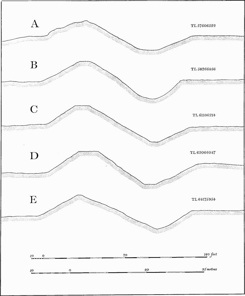
Fig. 125 The Devil's Dyke
Profiles at intervals A to E
In the 18th century, judging from Chapman's Map of Newmarket Heath (c. 1768), two trackways crossed the Dyke in this section. One from Swaffham Prior to Exning passed over it on the N.W. edge of the spur (TL 59046392); at this point the bank is partly pulled down but the remains indicate that the track was little more than a footpath. The other track from Burwell to Dullingham crossed the Dyke on the S.E. side of the spur (TL 59656336) where the bank has been almost cut away for 10 yds., but enough remains to indicate that there was never much traffic through the Dyke.
On the S.E. edge of the spur the Dyke again changes alignment (TL 59416355) though only by ½° to 132½° E. of N. (Fig. 124, e), and continues for almost 1¾ miles. From here the Dyke is on ground sloping S.E. after which it climbs the gentle N.W.-facing slope of Newmarket Heath. Along this section both bank and ditch are undamaged apart from occasional small quarries in the rear of the bank and four large gaps through the Dyke. The first, and largest, measures 100 yds. wide and is known as the Running Gap (TL 60156293) through which the Beacon Course passes (Fig. 5). Slight traces of both bank and ditch, detectable on the Course, show that the gap is not original; these features measure between 6 ins. and 1 ft. high. The gap certainly existed in the 18th century (Chapman's Map) and may date from the 17th century when the Beacon Course was laid out. However, the ancient 'Street way', now represented by green lanes running S.W.–N.E., is directed towards the gap suggesting that the gap may be of medieval or earlier date. A second, smaller gap, 700 yds. to the S.E., now known as the Stable Gap, was called the King's Gap in the 18th century (TL 60666250). No road, track or course is known to have passed through it; its date and purpose remain unknown but it is certainly not original. The gap through the bank and its accompanying causeway across the ditch is only 20 yds. wide, but on the S.E. side the top 8 or 10 ft. of the bank have been pushed forward into the ditch, half filling it, for a distance of 40 yds. producing a flat-topped raised terrace 2 ft. high and 15 yds. wide. The reason for this is unexplained.
A third gap, 600 yds. to the S.E. and now blocked, was always known as the Well Gap after a former nearby well (TL 61126211); 570 yds. beyond is a fourth gap known as the Cambridge Gap (TL 61506176). Both gaps have the same appearance and were originally about 30 yds. wide and with some later filling of the ditch. Subsequently most of the cutting through the bank was blocked by a narrower and lower bank leaving only a small footpath; the ditch was also completely filled by narrow causeways. All four gaps were cut to take tracks across Newmarket Heath, perhaps in the medieval period; the two last were narrowed and gated in 1763 to prevent avoidance of Turnpike Tolls (C.R.O., Minutes of Newmarket Heath Turnpike Trust, 1763–77).
Near the Cambridge Gap (TL 61446186) the Dyke again turns sharply on a new alignment (131° E. of N.) clearly visible as it climbs to a height of 100–150 ft. above O.D.; at the London Road Gap (TL 61936144) the direction again changes to 133° E. of N. (Fig. 124, f and g; Fig. 125, profile C).
The gap where the London road crosses the Dyke is only 30 yds. wide, but the Dyke is damaged and altered on both sides of the road. On the N.W., the ditch is filled in for a distance of 50 yds., and the rear of the bank is dug away in the garden of a cottage once the site of a toll house on the Newmarket Heath Turnpike. The bank has also been pulled down for 15 yds. to give access between the race courses. S.E. of the London road the bank has been almost removed by quarrying and by old tracks for a distance of 130 yds.; the ditch, largely filled in, is only visible as a depression 2 ft. deep.
At TL 62036135 the bank attains its full height and continues to climb the rising ground. At first the ditch has a wide flat bottom, 6–18 ft. deep, and has been ploughed in the past, before continuing as a deep V-shaped cutting. From this point until the Dyke reaches the summit of a rounded spur of chalk, projecting N.E. at just over 200 ft. above O.D. (TL 62696079), the earthwork is again visually impressive and largely undamaged. At TL 62226120 a stretch of the bank, 40 yds. long, is eroded by holes and small quarries; a small 5 yds.-wide gap through the bank with a narrow causeway across the ditch, is probably an old footpath although no gap is shown on Chapman's Map. Further along (TL 62426100), the ditch has been filled to a depth of about 4 ft. in two places, each 30 yds. long, but no purpose or date can be assigned to these alterations.
On the crest of the spur (TL 62696079) the Dyke changes alignment to 132½° E. of N., and drops down the steep slope of a broad N.-draining valley until it meets the DullinghamNewmarket road in the valley bottom (TL 63246034) (Fig. 124, h to i; Fig. 125, profile D). This section is undamaged except at two places. At the first (TL 62956056) a large rectangular 19th-century chalk pit on the S.W. side has obliterated the ditch for some 50 yds.; a further length of 50 yds., to the S.E., has been filled with quarry spoil, and the bank is also damaged. At the second (TL 63106045) the Cambridge-Newmarket railway line running N.-S. meets the Dyke at an angle. This line, constructed in 1848, runs on a low embankment and cuts through the top of the bank in a gap 30 yds. wide.
The Dyke then reaches the bottom of the valley at 160 ft. above O.D. and is crossed by the Newmarket-Dullingham road in a gap 60 yds. wide. In this gap is the usually dry bed of a small N.-flowing stream. As noted above there is a slight change in alignment at this point to 132° E. of N.; the ends of the bank are not directly opposed. Beyond this gap the Dyke climbs steeply up the S.E. side of the valley on a straight line until it reaches the edge of a flat-topped hill at 300 ft. above O.D. where it is cut by the Dullingham-Cheveley road (TL 64135957). The Dyke is almost undamaged along this section until it nears the road; about 200 yds. N.W. of the gap (TL 64005969) some 30 yds. of the forward edge of the bank have been dug away. Along this stretch an additional low bank, some 9 ins. high and 3 ft. wide, runs on the top and rear of the main bank which here forms the Stetchworth-Wood Ditton parish boundary. Immediately N.W. of the road, the bank is extensively damaged by quarrying, probably for road metalling.
At the road gap, only 40 yds. wide, the Dyke changes alignment slightly to 133° E. of N.; both bank and ditch are undamaged (Fig. 124, j). For the first 150 yds. beyond the road gap the form of the bank is irregular. It is only 3 ft. wide across the top (Fig. 125, profile E) and although its general alignment is straight the line of its crest has a number of sharp angles which cannot be explained by later quarrying or slumping.
Along this section (TL 64135957–64595912) the Dyke is the N.E. boundary of Stetchworth Park. Minor alterations have occurred probably connected with the use of the Park in the 19th century: N.E. of the House (TL 64405932) the forward face of the bank has been thrown into the ditch, and a little to the S.E. (TL 64435928) a narrow causeway across the ditch carries a footpath from the Park on to the bank. Further S.E. (TL 64545919) footpaths traverse the ditch diagonally.
Also N.E. of Stetchworth Park (TL 64435929) the Dyke makes its second major change of alignment, to 141° E. of N. (Fig. 124, k); this was probably necessary because the ground falls away to the N.E. into Dane Bottom. Had the alignment continued on a straight line the Dyke would have been below the crest of the valley side and consequently overlooked from the S.W. On the present alignment it skirts the valley edge for a short distance before dropping into a narrow tributary valley, orientated S.W.–N.E., at c. 270 ft. above O.D.
In the centre of this valley the Dyke is broken by a very narrow gap, 1½ ft. wide at the bottom and some 20 yds. wide at the top, which allows the stream to flow through (TL 64815890). The gap is probably not original, but made later in order to restore the natural drainage which the Dyke had blocked. There is no ditch in the valley bottom; it has apparently been silted up by debris washed into it by the dammed-up stream. Just to the S.E. (TL 64835889) the Dyke is damaged by a footpath cutting diagonally across it from N. to S.
Beyond, the Dyke climbs the S.E. side of the valley to 300 ft. above O.D. Along this section the ditch is markedly wide and flat-bottomed and has apparently been under cultivation at some time, but the bank is uneven with small quarries dug into it. It continues to ascend the rising ground to the S.E., and the land changes from chalk to boulder clay. The bank is undamaged except for a footpath which crosses it diagonally; the ditch is irregular, flat-bottomed and marshy, probably as a result of receiving water from the slightly higher clay land to the S.W. At TL 65235840 the Dyke turns sharply on an alignment of 131° E. of N. (Fig. 124, l) and the ditch becomes its normal V-shape. After 100 yds. the earthwork ends abruptly and there is no indication that it ever extended further.
Date and Function
There have been many attempts to date the construction of the Devil's Dyke and to explain its purpose, though none has been conclusive.
The earliest-known pronouncement was by William of Malmesbury who attributed it to King Knut (Gestd. Pontif. Rolls Series LII, 154–5). Camden (1551–1623) suggested that it was built by the East Angles against the Mercians (Gough, Camden II, 213). By the end of the 19th century there was general agreement that it was of pre-Roman date and built by the Iceni tribe on the frontier of their territory (C.A.S. Procs. VII (1892), 200–7). This theory was supported by observations carried out in 1884 when the Cambridge-Mildenhall railway was cut through the Dyke, but the results were not published for nearly 30 years (J.B.A.A., XIX (1913), 148–9). Although at this time Roman material was found in 'the surface earth of the bank', none was found under it; a pre-Roman date therefore appeared proven.
In 1923–4 the late Sir Cyril Fox undertook excavations on the Dyke near the Cambridge-Mildenhall railway (C.A.S. Procs. XXVI (1925), 90–129). He showed conclusively that the Dyke was erected on ground covered by Roman pottery from the nearby villa (Reach (30)). Fox thought that the pottery which he found was not necessarily later than the 2nd century A.D., although it is now regarded as 3rd-century. All the pottery was much abraded and Fox concluded that the Dyke was perhaps erected some time after the latest date of the pottery; a late- or post-Roman date was therefore suggested. Consequently Fox reasoned that the Dyke was likely to be 7th-century and built to protect East Anglia against the attacks by Mercia under Penda.
Work by Fowler and Lethbridge (C.A.S. Procs. XXXIII (1933), 113–16; XXXV (1935), 90–6) on Reach Lode and the Devil's Dyke also confirmed that the Dyke was later than the Lode which is certainly Roman. Lethbridge however was less confident of the 7th-century date for the Dyke and suggested that it, together with other dykes in the area, were immediately post-Roman in date and that they were constructed to prevent Saxon raiders taking cattle back to Norfolk and Suffolk. This was rejected by Phillips (V.C.H. Cambs. II, 9) who favoured the theory of a 6th- or 7th-century Saxon frontier defence. Lethbridge in a later revision (C.A.S. Procs. LI (1958), 1–5) proposed a late 4th-century date (A.D. 367), suggesting that the Dyke was part of a late-Roman military plan to block the retreat of Saxon raiders. A recent note on the Dyke (Arch. J., CXXIV (1968), 226–8) has suggested that it was either a part of a large 5th-century defence by Romano-British peoples in East Anglia, as a protection against Saxon settlers in the Cambridge area, or that it was a 6th-century construction by Saxon settlers in East Anglia against temporary British advances.
However, the date and function of the Dyke remain problematical. The date can probably be limited to between the late 4th and the 7th centuries. It is unlikely that its function was to prevent cattle-raiding. Its great size and careful planning designed to achieve strategic and tactical advantages would indicate that it was constructed essentially for military defence.
Fleam Dyke, Northern Section (Fig. 126)
Introduction
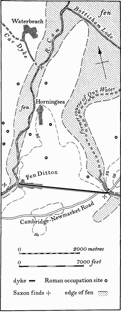
Fig. 126 Fleam Dyke, Northern Section
The northern or Fen Ditton section of the Fleam Dyke is a linear defensive earthwork, consisting of a bank with a ditch on its S. side, almost 2 miles long extending in a S.E. direction from the River Cam (TL 48106040) to Quy Water (TL 50955945). It lies totally within Fen Ditton parish. It is situated almost entirely on lower chalk, and although only 20 ft. to 25 ft. above O.D. at its ends it rises to 40 ft. to 45 ft. above O.D. along most of its length. The whole length of the Dyke is, and for long has been, badly mutilated or almost completely destroyed.
Siting
Strategically the Dyke would have prevented access from the S. to a large area of land now forming the N. part of Fen Ditton and all of Horningsea parishes (Fig. 126). Before the draining of the fens this was a roughly triangular area with its apex to the N.E., covering some 1800 acres, on lower chalk, gault clay and river gravel and sloping generally N.E. between 45 ft. and 15 ft. above O.D. The area was bounded on the S.W. by the Dyke, on the N.W. by the River Cam, on the N.E. and E. by the former fens and on the S.E. by the predecessor of Quy Water (see Stow cum Quy (26)).
Two tactical considerations apparently governed the siting of the Dyke. Firstly, advantage was taken of the high ground formed by the N. side of the asymmetrical valley which runsS. E. from the river for three-quarters of a mile, at the Fen Ditton end. Secondly, its alignment across flat ground as far as the edge of Quy Water was designed to control the river crossing where Quy Bridge now is. But for this consideration a shorter route, by 350 yds., would have been possible.
Description
The Dyke is in poor condition owing to the existence of Fen Ditton village which covers its N.W. quarter, medieval and modern agricultural activities, modern road works and the fact that for much of its length a road lies either on the bank or in the ditch.
As far as can be ascertained it runs straight, although there are indications that it originally curved back slightly at the ends. At its S.E. end, for a distance of 450 yds. (TL 50955945–50555949), the Dyke has been entirely destroyed by recent road works, although it is doubtful if any surface indications remained before these took place. The old alignment of the CambridgeNewmarket road at this point was probably on the top of the bank and the bend E.N.E. in the road just before it crossed Quy Water marks the original backward curve of the Dyke.
The most south-easterly point at which the Dyke still remains is where the present road to Fen Ditton met the old A 45 road (TL 50555949). Here, and for the next 830 yds. to the N.W., the road lies on top of the bank which is 60 ft. wide and 4–5 ft. high. Traces of the ditch up to 40 ft. wide and 2 ft. deep exist in a few places S. of the road. At TL 49855977 the road bends slightly and for the next 370 yds. it appears off the crest and partly in the ditch. Here a portion of the bank, 45 ft. wide and 2 ft. to 3 ft. high above the land to the N., remains immediately N. of the road. At TL 49505987, the road again bends and from this point to the railway bridge (TL 49146000), a distance of some 350 yds., both the bank and the N. half of the ditch still exist in a mutilated form N. of the road. The bank is 45 ft. to 120 ft. wide and 2 ft. high and the ditch is about 60 ft. wide and 1 ft. deep. W. of the railway bridge the Dyke has been entirely destroyed for about 100 yds., but at TL 49076004 the bank reappears and can be followed for 260 yds. until it reaches the outskirts of Fen Ditton village at Home Farm (TL 48846015). For the first 190 yds. of this length the bank is well marked: it is 10 ft. wide, 2 ft. high on the N. and drops steeply 4 ft. towards the road which apparently lies in the ditch. Just S.E. of Home Farm the S. face of the bank has been cut into for farm buildings and now remains as a steep scarp 5–6 ft. high with some traces of the other side of the bank in the field to the N.
In the S.E. half of the village as far as the crossroads (at TL 48576022) little survives of the Dyke (Fig. 47). The present High Street appears to be on the line of the ditch and a gentle rise in the gardens and yards on the N. side is probably the only indication of the bank. A slight N.-facing scarp in the S.E.–S.W. angles of the crossroads may be the S. lip of the ditch; this may have survived as a pond which lay in the S.W. angle in 1807 (C.R.O., Enclosure Map).
N.W. of the crossroads the High Street is on the line of the ditch, but the only indication of the bank is at the extreme N.W. end of the street (TL 48266036). On the S. side of the churchyard, a lane leading down to the River Cam in a deep cutting is probably in the original ditch, and a long narrow pond which existed here in 1807 (C.R.O., Enclosure Map) probably occupied part of the ditch; the bank is also traceable. W. of the church the line of the bank is only reflected by the sunken lane and by a channel to an old wharf (Fen Ditton (39)). This cut curves back N.W. to the River Cam and may be on the line of the original ditch.
There is no indication along the line of the Dyke of an original entrance, although it may have been obliterated. The original dimensions of the bank and ditch are unknown, but most authorities (e.g. Fox, A.C.R., 126) maintain that this northern section of Fleam Dyke was not comparable in scale with the southern section. However the present overall width of the partly-spread bank and ditch is around 180 ft., indicating a barrier of considerable size.
Date and Function
In the absence of excavation little is known of the date and purpose of the Dyke, but some related features may be noted. The other main dykes in Cambridgeshire, the Devil's Dyke, Fleam Dyke (southern section) and the Bran or Heydon Ditch, are undoubtedly late- or post-Roman. They span the chalk ridge between the formerly forested area to the S.E. and the fens and the River Cam to the N.W., so blocking access along the line of the Icknield Way. However, the siting of the northern section of Fleam Dyke differs from the others in that it prevented access only to a relatively small area of land behind it, perhaps implying a different function and date. Unlike the other three, no use is made of this Dyke as a parish boundary for it lies entirely within the parish of Fen Ditton whose S. boundary was formerly some distance away. The Dyke therefore may not have been regarded as a notable landmark at an early date in the historic period. Similarly the existence of the village of Fen Ditton, lying across the Dyke and using the ditch as its main street, perhaps indicates an early abandonment of the Dyke. The village is recorded by the late 10th century (D. Whitelock, Anglo-Saxon Wills (1930), 35, 40; C. R. Hart, The Early Charters of Eastern England (1966), nos. 50, 58) and can be regarded as an early settlement in the area.
The present name of Fleam Dyke for the northern section is misleading and of no great antiquity. The road along the Dyke is called High Dyke Road, a name in use by 1821 (Baker's Map of Cambridgeshire). The name was also preserved in High Ditch Field, the easternmost of the common fields of the parish, which lay across the line of the Dyke (see Fen Ditton (42)). In addition there are references to a 'Heyditch' in the 13th century (Reaney, Place-names of Cambs., 142). The difference in position, character and name argues against a connection between this Dyke and the Fleam Dyke proper.
The only associated archaeological finds from the Dyke are the Pagan Saxon burials discovered during road-widening at the end near Quy Water (TL 50605940) (see Fen Ditton (38)). These objects were said to have been buried in the very top of the filling of the ditch, indicating that the Dyke may have been of some antiquity or become disused when the burials were made. The relationship of the burials to the Dyke may be fortuitous.
Dykes in comparable situations, and perhaps of similar size, are the two so-called Devil's Dykes in West Norfolk which cut off promontories extending into the fens between the rivers Nar, Wissey and Little Ouse (Fox, A.C.R., 133).
The Fleam Dyke (northern section) appears then to be unconnected in purpose, and perhaps date, with the other main Cambridgeshire dykes. It would seem to be a defensive work which formed one side of a large promontory fort; it had apparently fallen into decay at an early date in the historic period.
The dating of this northern section of Fleam Dyke has long been the subject of discussion. Firstly, Fox believed that an Iron Age date was possible but the lack of appropriate finds in the vicinity and the straight alignment of the earthwork do not support this contention (A.C.R., 32–4). Secondly, an early post-Roman origin would be reasonable on the evidence provided by the sites of four Roman settlements lying behind the Dyke in Horningsea; in this event it may have been built by Romano-British people as a defence against early Saxon settlers in the Cambridge area. There is, however, no indication of late Roman activity. Thirdly, it may have been built by the early Saxons while in temporary retreat from the Cambridge area; although no Saxon site is known behind the Dyke, some Saxon weapons, dredged from the River Cam near Clayhithe (TL 501644) are recorded. (C.A.S. Procs. XXXIII (1933), 167; V.C.H. Cambs. II, 10; Fox, A.C.R., 126, 132–4)