An Inventory of the Historical Monuments in the County of Cambridgeshire, Volume 2, North-East Cambridgeshire. Originally published by Her Majesty's Stationery Office, London, 1972.
This free content was digitised by double rekeying. All rights reserved.
'Horningsea', in An Inventory of the Historical Monuments in the County of Cambridgeshire, Volume 2, North-East Cambridgeshire(London, 1972), British History Online https://www.british-history.ac.uk/rchme/cambs/vol2/pp65-74 [accessed 30 April 2025].
'Horningsea', in An Inventory of the Historical Monuments in the County of Cambridgeshire, Volume 2, North-East Cambridgeshire(London, 1972), British History Online, accessed April 30, 2025, https://www.british-history.ac.uk/rchme/cambs/vol2/pp65-74.
"Horningsea". An Inventory of the Historical Monuments in the County of Cambridgeshire, Volume 2, North-East Cambridgeshire. (London, 1972), British History Online. Web. 30 April 2025. https://www.british-history.ac.uk/rchme/cambs/vol2/pp65-74.
In this section
4 HORNINGSEA
(O.S. 6 ins. aTL 46 S.E., BTL 56 N.W., CTL 56 S.W.) (Fig. 62)
The parish, of 1640 acres, has an elongated shape and is bounded on the W. by the River Cam. Its irregular southern boundary interlocks with Fen Ditton parish (see p. 47) with which it was once unified. A spine road runs from the S. to the river-crossing at Clayhithe, and the Hundred Rolls of 1279 suggest that settlements existed at Horningsea, Eye Hall (33) and Clayhithe. Habitation around Eye Hall had been considerably reduced by 1810, the date of the Enclosure Map. The present straight road running in the vicinity of Eye Hall may have replaced a winding road but any alteration had taken place before 1810. The village now stretches on either side of the spine road but the earlier buildings, including the church, lie on its western side. Two lesser roads run at right angles to the river bank and terminate as wharves (34) and (35).
Ecclesiastical
a(1) Parish Church of St. Peter (Fig. 63; Plates 15, 16) stands W. of the village street on high ground adjacent to the river. It consists of a Chancel, Nave with Aisles, South Porch and West Tower. The walls are of 'Barnack' ashlar, flint, clunch and other rubble with limestone quoins; the tower is largely cement-rendered. The roof of the chancel and nave is tiled and the aisles and porch are lead-covered.
A passage from the Liber Eliensis, a product of the Benedictine house of Ely, indicates that a minster with a sizeable community of secular canons existed at Horningsea at least as early as the 9th century; it reads: 'Priusquam paganorum rabies, qui in Orientali Anglia debachati erant, circa provinciam Grantebrugie efferbuisset terramque vastationi et desolationi tradidisset, apud Horningeseie monasterium regie dignitatis extitit eratque ibi non parva congregatio clericorum' (Liber Eliensis II, 32 (Camden 3rd series, XCII (1962), 105–6)).
After the restoration of Ely as a Benedictine house in c. 970 Horningsea became a possession of the abbey. It was a wealthy property providing two weeks' victuals to the parent house under the reorganisation by Abbot Leofsin (1029–44) in the reign of Knut (ibid. II, 84, Camden, 152–3). Domesday Book records an assessment of seven hides and a valuation of £18. Between 1210 and 1214 Bishop Eustace granted the church to the Hospital of St. John at Cambridge, and in 1267 Bishop Hugh Balsham added the Vicarage (W. K. Clay, History of Horningsea, C.A.S. 8vo. Publ. VII (1865)).
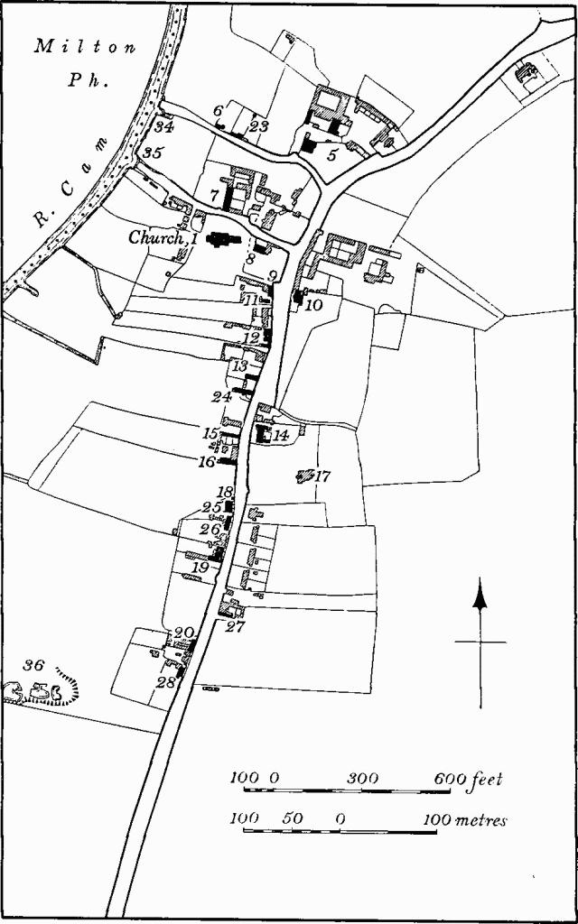
Fig. 62 Horningsea, Village Map
No pre-Conquest work remains in position but a fragment of a coffin lid of the late 10th or 11th century survives (Coffin lid (1)). The unusual plan with a broad E. pier to each arcade, and long E. responds forming recesses at the ends of the aisles, indicate an earlier building with small porticus projecting N. and S. some distance W. of the E. end of the nave.
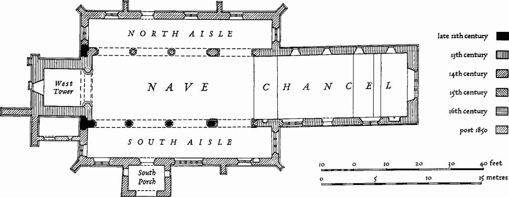
Fig. 63 Horningsea (1), The Parish Church of St. Peter
Reused 'Barnack' ashlar at the base of the chancel walls suggests that the E. end was rebuilt in the 12th century, probably on a larger scale. Late in the century the nave side-walls were pierced with arcades of three bays of which that on the S. remains. These aisles seem to have stopped against the older porticus which was still entered through narrow arches from the nave. Early in the 13th century the present lengthy chancel was built, involving the complete demolition of the earlier chancel and of the E. end of the nave as far as the E. walls of the porticus. A return at the E. end of the N. aisle infers an intention for a general rebuilding with a view to making continuous aisles and removing the porticus. The W. tower also dates from the 13th century. The aisles had to wait a century or more for the intended reconstruction. The N. arcade in its present form belongs to the 14th century but diagonally-tooled ashlar of some piers indicates the re-use of material probably from piers of the same dimensions. The N. aisle, rebuilt with the arcade in the 14th century, was extended eastward and the narrow porticus-opening widened to the W. Later in the 14th century, the S. aisle was rebuilt and the porticus-opening made wider in conformity with that on the N.; the S. porch was added at the same time. A medieval rood screen with an altar in the gallery is attested by a piscina 12½ ft. above floor level.
Extensive restorations took place in the 19th century, the chief being in c. 1850 when the chancel was renovated, in 1865, and in 1890 when the tower was repaired.
The church is interesting for the complex plan reflecting its long history.
Architectural Description.—The Chancel (19 ft. wide), of the 13th century, is built of reused 'Barnack' ashlar, presumably of the 12th century, below the window sills; above, the walls are of clunch, flint and rubble. The much-restored late 14th-century E. window of three lights with vertical and quatrefoil tracery, has external label and rear-arch with recessed panel terminating on bracket-stops at the springing. In the N. wall are four lancets with restored trefoiled heads, original splays, chamfered rear-arches and later flat sills. The first window in the S. wall has a lancet with trefoiled head and high sill above the piscina; the second, of two cinquefoil-headed lights, has vertical tracery with quatrefoil in the apex, external label with mutilated stops, an acutely-pointed head, panelled recess to rear-arch and is late 14th-century; the third bay contains a 13th-century doorway with external chamfered jambs, hood-mould and plain internal jambs, and above is a lancet with trefoiled head; the fourth window of three cinquefoil-headed lights with vertical tracery in a four-centred head, is late 15th-century. Below, and visible externally, is the sill of a former window, presumably a 'low-side'. A step 39¾ ft. from the E. reflects the position of the rood screen with an altar in the gallery and another at ground level (see Piscinae (2 and 3)).
The Nave (19 ft. wide) of four bays has on the N. and S. broad piers, with double responds, between the first and second bays. The early 14th-century N. arcade of two unequal chamfered orders has an E. respond with chamfered and roll-moulded base, semi-octagonal limestone pier and moulded clunch capital with necking; the corresponding features on the broad pier are similar. The E. respond sub-base may be a survival of the older opening to the porticus, the present arch being a 14th-century widening in a westerly direction; some diagonally-tooled pier-stones are reused. The remaining two octagonal piers are of clunch and have capitals uniform with those in the first bay; the bases are triple roll-moulded except for the second which is now chamfered but may have been cut back. The design is repeated in clunch for the W. respond. The S. arcade of four bays has in the first bay a 14th-century arch of two chamfered orders carried on semi-octagonal clunch responds, that on the E. having square, chamfered, limestone sub-base, double roll-moulded base and hollow-moulded limestone capitals with necking; the E. capital has a single hollow chamfer and the W. a double hollow chamfer. The E. respond-base may be a survival of the former opening into the porticus. The other three bays, in clunch of smaller-sized blocks than are used in the N. arcade, have late 12th-century arches with double chamfers to the nave and deep rebates to the aisle. The semi-octagonal E. respond on the broad pier (Fig. 64) and the second octagonal pier have multi-scalloped capitals beneath coves at a higher level than the capitals in the first bay; details of the chamfered bases vary. The third pier and the W. respond have octagonal chamfered sub-bases and hollow-chamfered bases and capitals with double hollows and necking. The crude hollow-chamfered capitals may be recut from scalloped capitals. The wall-thickness of the S. arcade extends the full width of the capitals and is carried on a flat corbel at capital level on the broad pier.
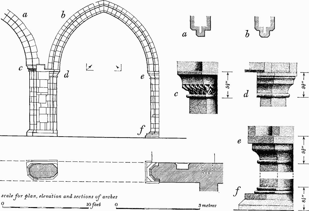
Fig. 64 Horningsea Church, South arcade
south side of first bay
The North Aisle (56¼ ft. by 8¾ ft.), of rubble and fieldstones, has been largely rebuilt except for the W. wall which retains the rough junction between the W. wall of the 12th-century nave in coursed rubble and the early 14th-century aisle. The 'Barnack' ashlar of the chancel returns as bonding stones for the full height of the wall at the junction with the E. wall of the aisle. The aisle has E. and W. diagonal buttresses and two side buttresses. The windows, which have flowing tracery of early 14th-century character, are all late 19th-century but the internal sills are mostly original. The N. doorway has renewed dressings.
The South Aisle (56½ ft. by 9½ ft.), of limestone and other rubble, has E. and W. diagonal buttresses of two weathered stages, and two side buttresses. A moulded string-course below a former parapet survives and is interrupted by a gargoyle in the form of a grotesque animal. The segmental-pointed E. window of three pointed lights with trefoiled spandrels, cinque-foiled sub-arches and cusped quatrefoils, has external and internal labels and continuously moulded jambs and head; the pronounced angularity of the springing suggests a date in the second half of the 14th century. The first window in the S. wall is similar to that in the E. but of two lights without an internal label. The second window of five elliptically-headed lights with sunk spandrels in a square head, moulded externally, is early 16th-century. The late 14th-century S. doorway has a two-centred head, continuous casement-moulded jambs and head enriched with paterae and carving of a pelican in piety, label with head-stop on the W., segmental-pointed and chamfered rear-arch and plain jambs. The third window is entirely 19th-century, as is the eccentrically-placed W. window except for an internal segmental rear-arch, possibly of the late 14th century. High up in the W. wall and visible externally is the rough junction between the 12th- and 14th-century walling repeating a similar joint in the N. aisle.
The South Porch is late 14th-century. It is built of rubble with red brick patching on the E. and reused limestone quoins; it has a low-pitched lead-covered roof formerly with a parapet, the lower string-course of which survives. On the S. the string-course drops to meet angle-gargoyles in the form of grotesque lions with tufted manes. The S. archway has plain jambs and modern head; above is a trefoil-headed niche with stop-chamfered jambs and sunk spandrels. In the E. and W. walls quatre-foiled window openings with sunk spandrels, renewed internally, are late 14th-century. The present roof replaces one of steep pitch, tile-covered with plain eaves, of post-medieval date, which is shown on photographs of c. 1885 (C.A.S. Library).
The West Tower (11 ft. by 11½ ft.), of the 13th century, has cement-rendered walls with ashlar quoins and dressings. It is in four stages separated by string-courses which are chamfered above and below. Two N.W. angle buttresses and a W. side buttress, which rise to the lowest string-course, are in three weathered heights. Two late medieval S.W. angle buttresses are in three weathered heights and rise to the third string-course. On the E. face of the S. buttress is the flat-pitched weathercourse of a former outshut on the site of the present one; as there is no indication of a doorway into the church, a special use for the annex, such as a charnel-house, is inferred. In view of the eccentric position of the W. aisle-window, a 14th-century date for the former annexe is implied. The tower arch has two chamfered orders on the E. and one on the W. with plain, plastered rear-arch; the semicircular responds, with moulded bases and scalloped capitals, are probably late 19th-century. The W. window is a plain lancet with chamfered external jambs and head, renewed internal jambs and segmental head. The third stage has on the W. a small round-headed lancet with chamfered jambs. In the fourth stage each face has a two-light window of c. 1400 with trefoil-headed lights, vertical tracery and external label. Below the brick battlemented parapet of c. 1825 (Clay, op. cit., C.A.S. VII (1865)) the fourth string-course terminates with angle-gargoyles in the form of grotesque demi-animals, now much eroded.
The Roofs of the nave and chancel were rebuilt in the late 19th century at a higher level to conform with a weathercourse, now barely visible, on the E. face of the tower. Photographs of c. 1885 (C.A.S. Library) show a slightly lower-pitched tiled roof well below the weathercourse which terminated with a truncated top at the sill of the belfry window.
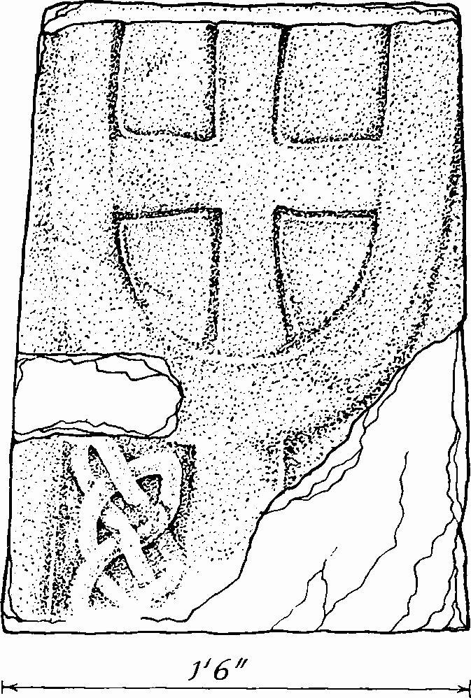
Fig. 65 Horningsea Church, Fragment of Coffin lid (1)
Fittings—Bells: 4th by Christopher Graye, 1680, recast 1938; 5th inscribed 'Iohanes Draper mefecit 1608'. Books: Bible, 1827; Book of Common Prayer, 1840; both inscribed 'Horningsey Church, 1841' on fly leaves. Coffin lids: in N. aisle—(1), in E. wall, fragment with incised cross in U-shaped terminal and interlace at side of central shaft, late 10th- or early 11th-century (Fig. 65); (2), fragment with omega ornament, ridged, early 13th-century; (3), fragment with floriated cross from head-end, ridged with moulded edge, 13th-century. In S. aisle—(4), length 4 ft. 3 ins., with central omega ornament, wheel cross and stepped base, ridged with moulded edge, early 13th-century (Plate 40); (5), length 6 ft. 4 ins., decoration defaced, ridged, probably early 13th-century; (6), larger part of lid with moulded edge, defaced decoration at head-end and ornament of semicircular relief pattern and stylized bird flanking central raised rib, 13th-century (Plate 40). (4), (5) and (6) were found in 1847 in the churchyard (Cutts, Sepulchral Slabs and Crosses (1849), 16, Pls. LII, LIII, LXV). Font: octagonal bowl with deep uncarved sides, lead-lined, set on one central and four peripheral octagonal columns each with splayed capitals, necking and tripleroll bases, stands on moulded octagonal base and large octagonal foot-pace, early 13th-century (Plate 39). Glass: in E. window of chancel, fragments in tracery include some roundels, late 14th-century and 15th-century; in E. window of N. aisle, in tracery, yellow and black fragments include reset canopy-work, 14th-century; in E. window of S. aisle, in tracery, in situ, bordered red and blue quarries, and in central light, shield of the Trinity in black and white against a blue background, late 14th-century; spandrels contain reset 15th-century fragments with architectural decoration; in S. window of S. aisle, in tracery, bordered blue quarries and some ochre-coloured glass with floral pattern, late 14th-century, some in situ; in tracery, red and green with Α and Ω, mid 19th-century.
Monuments and Floor slabs. Monuments: in churchyard, three early 18th-century headstones with emblematic carving; tomb chest in cast-iron with panelled sides, one with cast inscription to Jonathan Fison, 1844, originally painted stonecolour, surrounded by cast-iron railings and plinth. Floor slabs: in nave, black ledger to Thomas Willys, 'February 1625', with shield of arms of Willys. Niches: in S.E. angle of S. aisle, with ogee cusped and sub-cusped head, hacked-back label terminating with a finial, now mutilated, and having an embattled and covered cornice, moulded jambs with bull-nosed stops; a shelf, carried on roughly-chamfered corbels, supports a semi-octagonal image-base enriched with cusped diapering; second half of 14th century. Piscinae: in chancel, S. wall— (1), double piscina with central column with pointed heads, largely 19th-century, and chamfered sill with two drainsinkings, the E. quatrefoil and the W. rectangular, 13th-century; at W. end of S. wall—(2), 12½ ft. above floor level, rectangular recess with chamfered head and jambs, with square drain-sinking, medieval; below (2) and W. of it—(3), with chamfered trefoiled head and quatrefoil sinking, 13th-century. In S. aisle, S. wall—(4), with arched head, chamfered within and without and having broach-and-bar stops, hackedback shelf and rectangular drain-sinking with diagonal ribbing and pierced central boss, second half of 14th century. Plate: includes a cup (ht. 5½ ins.) with locative inscription and date '1569', by Thomas Buttell (Plate 62); cup (ht. 8 ins.), silver gilt, beaker-shaped bowl on trumpet foot, inscribed as gift of St. John's College in 1829 and bearing its arms, 1635 (Plate 62); cover paten belonging to the foregoing, silver gilt, inscribed as on cup but with sacred monogram in an aurora, not marked but presumably 1635. Pulpit: oak, octagonal with modern base, linenfold-panelled sides and door, scroll-patterned upper panels, five scroll brackets taking shelf, possibly an addition by a few years, linenfold back panel to tester which is enriched with pendants between arches, bracketed cornice and panelled star on soffit; c. 1600 (Plate 61). Scratchings: on voussoirs of S. door, undeciphered inscription, medieval (C.A.S. Procs. XIX (1915), 61, Pl. XV). Screen: the lower part of a painted wooden screen recorded in 1844 does not survive (F. A. Paley, Churches near Cambridge, 3). Seating: oak, eight pews in nave and seven in S. aisle, with top rails and miniature buttresses to the returns and rear benches; late 15th-century. Table: oak, with moulded legs, stretchers and drawer with brass drop handles, early 18th-century. Miscellaneous: loose in first stage of tower, stone fragments including broken column from font and seven crockets or finials, medieval.
Secular
a(2) Conservators' House (TL 50226443; Plate 95), of two storeys with cellars, white brick with stone dressings and tiled roofs, has stone date-letters '1842' on the N. gable. The house is in the Tudor style with dutch gables. The main entrance has an ornamental architrave and the windows have mullions and transoms. Inside, a large committee room for the Conservators of River Cam, on the W., has little decoration except for a plaster cornice with acanthus decoration. On the E. and over the committee room are living quarters of a mundane character. The extensive cellars are barrel-vaulted.
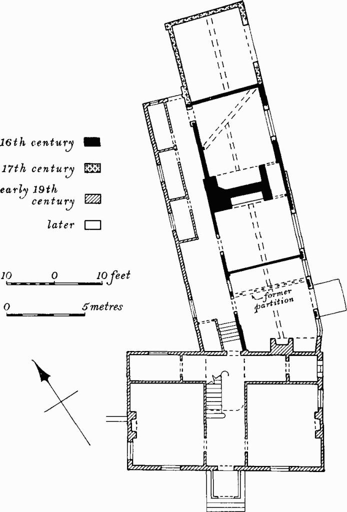
Fig. 66 Horningsea (3), Eye Hall
a(3) Eye Hall (TL 49896363; Fig. 66) consists of a house and farm buildings. The House includes a framed and plastered N. range of the 16th century and an early 19th-century S. wing replacing a former cross wing. The two-storey N. range consists of four rooms and central chimney stack. It is cased in white brick on N. and E., and has a tiled gabled roof. The two rooms S. of the added stack are probably earlier than the stack and the room immediately to the N. The fourth room was added probably in the 17th century. Inside, the part S. of the stack is in two and a half bays; a former partition enclosing an E.-W. screens passage with a door is inferred by a cross beam with mortices. Each bay has an exposed axial beam and joists; on the first floor a wall post with enlarged head is morticed for a large arch brace. The N. room has a dragon beam indicating former jetties on the N. and E., and perhaps implying a former cross wing. The 19th-century S. wing, of two storeys and cellars, white brick and slated hipped roof, has a symmetrical S. front of three bays. It contains a stair with scroll brackets on an open string and a first-floor landing with concave angles.
The Farm Buildings include: an unaisled timber-framed barn of eight bays with thatched half-hipped roof, early 17th-century; an aisled barn, timber-framed, of three bays with thatched half-hipped roof, probably 18th-century; a twostorey granary, of red and yellow brick with gabled roof, originally open on the W. side of the ground floor, with a stop-chamfered beam, early 18th-century; a stable, of brick with tiled gabled roof, and harness room with lean-to roof, late 18th-century.
a(4) The Lodge, of two storeys and cellar, white brick with parallel slated and gabled roofs, was built as a Class-T house early in the 19th century and enlarged to a Class-U plan in c. 1840 by the addition of two rooms beyond a wide passage. The earlier range, until recently thatched, is shown on the Enclosure Map of 1810. Interior fittings include a grey marble fireplace with angle-roundels, and a white marble fireplace of c. 1820 removed from West Road, Cambridge in 1967.
a(5) Manor Farm, of two storeys and attics, is timber-framed partly cased in white brick, with slated roof and parapeted gables. It originated as a large Class-I house of the 17th century; possibly in 1843, the date of the nearby stables, it was enlarged and reorientated to form a Class-U house by the addition on the N. of service rooms and a study beyond a stair hall. On the S. are two two-storey bay windows, essentially of the 17th century, which were until recently surmounted by gables rising from projecting eaves carried on shaped brackets. The house was mostly refenestrated with sashes in the mid 19th century. Inside, the earlier range has a large lobby and axial stop-chamfered beams. The early 19th-century staircase has spiral terminal with moulded iron newel.
The Stables, N. of the house, are in white brick with slated gabled roof. The coach house on the W. carries a stone panel inscribed 'H. Norris Esq. 1843' and the E. range a panel, 'S. Fox Arch. Bu(r)y 1843'.
a(6) House, Class S, of one storey and attics, timber-framing cased in brick, with thatched gabled roof, was built c. 1800 incorporating a large brick stack, originally internal and probably 18th-century.
a(7) Parsonage Farm includes a softwood timber-framed Barn of six bays of uncertain date but perhaps 18th-century. Each roof truss consists of a straight tie beam braced to wall posts, queen struts, and collars clasping purlins. The enlarged heads of the wall posts have shaped profiles.
a(8) Old Rectory (Plate 112), of two storeys, with white brick and slated gabled roof, was built in 1833 at a cost of £332 (H. F. Howard, An Account of the Finances of St. John's College 1511–1926 (1935), 336–8). Built to a Class-T plan it subsequently received additions under a lean-to at the rear. The entrance has a fanlight with lozenge-wise glazing bars, and the main windows are sashes. Inside, the fittings include a fireplace surround with angle-roundels and two 17th-century cupboard doors with run-through panelling. N. of the house is a small white brick stable and coach house of the early 19th century.
a(9) Crown and Punch Bowl, inn, of two storeys, timber-framing partly cased in white brick, with hipped and half-hipped roof, was built in the 18th century and was extended on the W. in the 19th century. Inside, the main range has two unequally-sized rooms with axial ceiling beams flanking a large internal chimney stack.
a(10) King's Acre, of the late 19th century incorporates the base of an earlier chimney stack. Inside, reused material includes stop-chamfered ceiling beams and some run-through panelling of the 17th century and an early 19th-century moulded fireplace surround with angle-roundels.
a(11) House, of one storey and attics, white brick possibly casing a framed structure, with thatched gabled roof, was built in the early 19th century. The plan approximates to Class I but there are external doors to each room.
a(12) Terrace, consisting of three Class-S dwellings, a former shop and a carriage entry, of one storey and attics, white brick with tiled mansard roof, is early 19th-century. The former shop has a larger sash window than the others; a continuous outshut at the rear has been heightened.
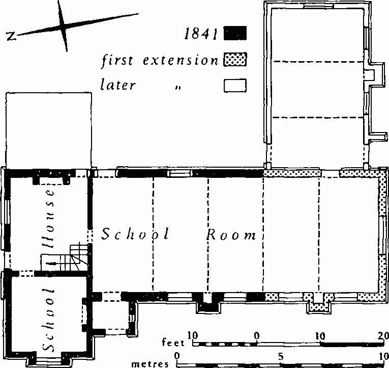
Fig. 67 Horningsea (14), Former School
a(13) House, Class G, of one storey and attics, framed, partly plastered and partly weather-boarded, has a thatched roof which is gabled on the E. and half-hipped on the W.; it is 17th-century. The chimney stack has four shafts arranged diagonally on a square base. Inside, axial beams in the two main rooms are chamfered; the E. compartment is divided axially by an original partition, providing two unequal service rooms.
a(14) Former School and School house (Fig. 67), with white brick walls and slated roof with parapeted gables, was built as a National School for 81 pupils in 1841 at a cost of £375 6s. 9d. (Parish Records; National Society for Religious Education archives). The one-storey schoolroom, and the house with attics, are built in the Tudor style with wooden mullioned and transomed windows; over the four-centred porch doorway is a stone panel inscribed 'sinite parvulos venire ad me'. Shortly afterwards, the schoolroom was extended by two bays on the S. and later again increased by an addition on the E. in a similar style.
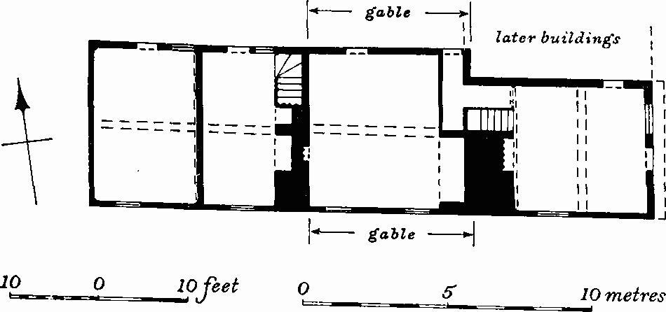
Fig. 68 Horningsea (16), The Square
a(15) Terrace of three Class-S dwellings, of one storey and attics, timber-framing cased in white brick, tiled roof with parapeted gables, may have been a late 18th-century stable, associated with (16), which was extended to the E., cased in brick, and converted into houses in the 19th century.
a(16) The Square (Fig. 68), of two storeys and attics, timber-frame partly cased in brick, with tiled roofs, is in three units running E. and W., but the development is enigmatic. The E. and centre units are probably early 17th-century and the W. unit slightly later. The narrower E. unit has a jetty at the gable end. The centre unit has flush gables on the N. and S. with a high ridge at right angles to the main axis. The W. unit has a roof with a still higher ridge and a half-hip on the W. The E. section consists of a single room of two bays on both floors, with cross beams, and a chimney bay on the W. containing a large stack with back-to-back fireplaces. The central bay, beneath the flush gables, has a chamfered beam on the E.-W. axis. The W. range with attics consisted originally of a single room with intersecting beams, and a chimney stack within the room at the E. end; the roof has evidence of shallowly-inclined arch braces.
In the garden of the adjacent modern house to the S. are several medieval fragments of limestone including one with weathered top and moulded return, possibly a window sill and jamb, another with blind cusping, and a third with a mason's mark.
a(17) Vicarage, contains a staircase with reused early 18th-century oak balusters, with alternately fluted and twisted shafts, and turned caps and bases; said to be communion rails from St. John's College chapel, Cambridge.
a(18) Workshop, of white brick and slated gabled roof, consists of a single room with fireplace; mid 19th-century.
a(19) House (Fig. 69), known as The Priory, of two storeys, timber-framing partly cased in brick, with tiled gabled roof, hipped on the N., is 16th-century. The house, which is notable for the quality of its timber-work, has an abnormal T-shaped plan. Dual occupation by branches of one family is perhaps implied. The S. range, the E. gable of which has a first-floor jetty, had originally three ground-floor rooms and a centrallyplaced chimney stack. The E. room, evidently the parlour, has stop-chamfered ceiling beams and joists; the middle room, with chamfered beams and plain joists, was separated from the W. compartment by a former partition; a use as a 'hall' or kitchen with buttery may be conjectured. The N. range comprises a central chimney stack with a room on the S., perhaps originally a 'hall', having stop-chamfered ceiling beams and joists similar to those in the S. range. N. of the stack is a cross passage and evidence of a former plank-and-muntin partition with three doorways, presumably leading to butteries and a stair, but only one axial partition remains. On the first floor, a number of original windows are inferred by shutter grooves and the arrangement of studwork. The roof has braced cambered tie beams, and collars clasping purlins. Internal fittings include 17th-century reused run-through panelling and a door.
a(20) Plough and Fleece (Plate 110), inn, Class J, of one storey and attics, white brick with tiled mansard roof, is late 18th- or early 19th-century. Sale particulars of 1842 (C.R.O., R51/2/50) describes it as a 'brick and tile house recently put in complete repair'.
b(21) House, at North Hills (TL 51276510), Class T, of two storeys, timber-framing cased in brick, pantiled gabled roofs, is early 19th-century.
a(22), a(23), a(24) a(25), a(26), a(27), a(28) Houses, are pairs of Class-S dwellings. (22), (23), (24) and (26), of one storey and attics, some retaining their thatch, are c. 1800; except for (22) the stacks are internal. (25), (27) and (28), of two storeys, white brick and slated gabled roofs, are early 19th-century.
Earthworks
Roman
a(29) Roman Settlement and kilns (centred TL 496634; Fig. 70), lie S.W. of, and probably under, Eye Hall on river gravel, gault clay and chalk marl at about 20 ft. above O.D. Evidence of Roman occupation has been recorded over an area of about 40 acres. Finds show that in addition to extensive pottery-making activity there was a domestic settlement of considerable size.
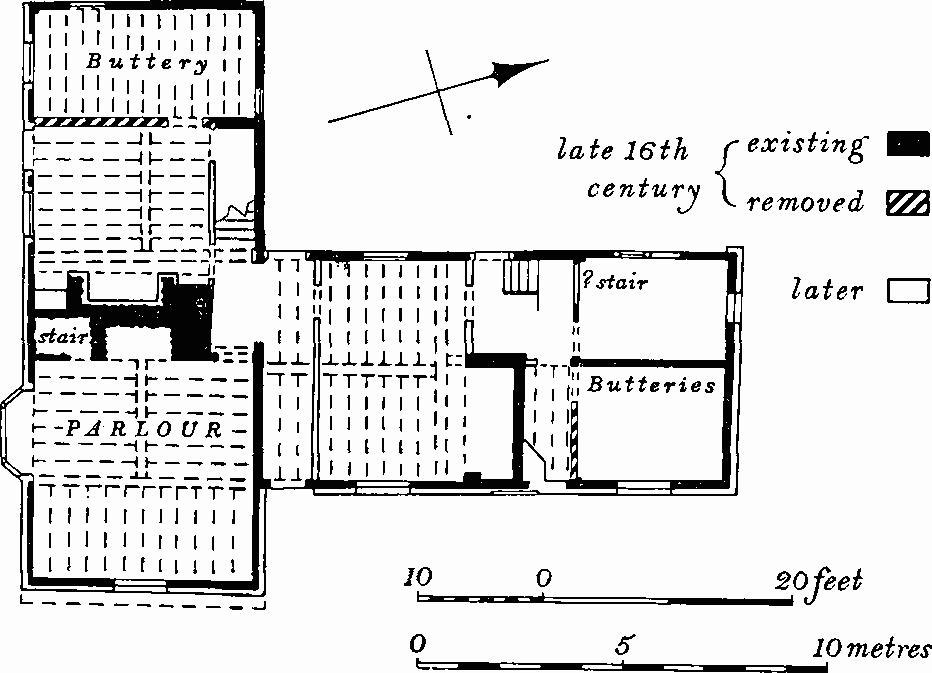
Fig. 69 Horningsea (19), Plan of House
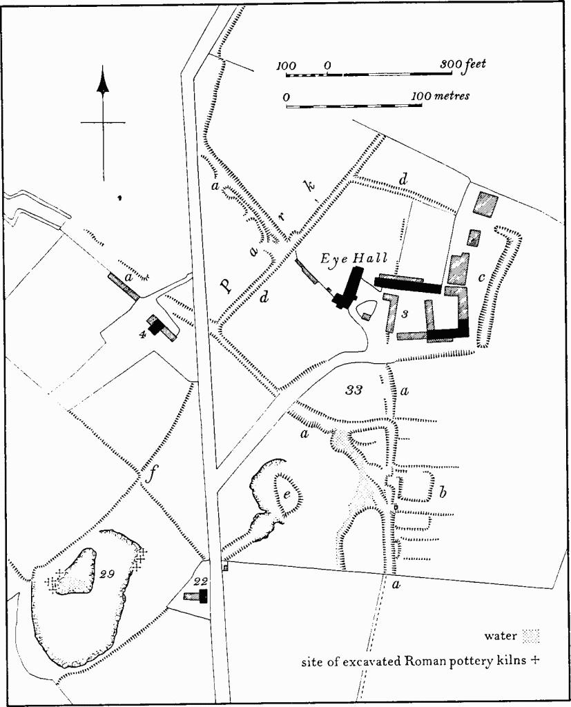
Fig. 70 Horningsea (29, 33)
Earthworks near Eye Hall
The site was first noted in the late 19th century when part, S.W. of Eye Hall (TL 496634), was being worked for coprolites. Large quantities of Roman pottery and a number of 'ovens' were found over an area of about 15 acres. Further finds were made there by T. McKenny Hughes at the beginning of this century; he also carried out excavations S. of Eye Hall (TL 498634). A mound (see (33)) and a 'well' were dug into but both are unlikely to have been Roman although large quantities of Roman pottery and lumps of baked clay were found in the former.
Excavations by F. G. Walker in 1911 S.W. of Eye Hall (TL 49666341–49736344) produced seven kilns, one of which lay on top of another, and a third had been rebuilt at least twice. The kilns were of inverted cone shape, and some had a series of rounded baked clay pilasters projecting from the furnace walls. Three of the kilns had four single pilasters, and two had eight arranged in four groups of two. All the pilasters had flattened tops presumably to support some form of floor, but no trace of fire bars or central supports were found. A large quantity of roughly-shaped baked clay plates, generally circular, 4–5 ins. in diameter, were found in and around the kilns, and the lower half of one kiln was lined with them.
The pottery from these kilns, which has been found in large quantities, consisted mostly of large storage jars up to 2 ft. in height in grey ware, often with a grooved decoration in the lower parts of the sides. Other types of local pottery included pedestal-jars, shallow bowls, and indented beakers in colour-coated ware. Large numbers of very small pots, some under 2 ins. high were found. The kilns were believed in 1911 to date from the 1st—4th centuries A.D., but are now regarded as being late 2nd—3rd century.
In addition to locally-made pottery, there was also Samian ware, some of late 2nd-century date. Other finds from the vicinity of Eye Hall include coins, bone pins, 'bronze cooking pans' and fibulae, as well as large quantities of pottery. A large settlement associated with the kilns is certain. One rectangular structure, 10 ft. by 7 ft., found in 1911 S. of Eye Hall (?TL 49956347), had walls of mortared flint rubble up to 2 ft. high; it was said to be of Roman date, but the evidence is dubious. (C.M.; C.A.S. Reports, LXV(1885), XXXIII, I; C.A.S. Procs. IV (1903), 186; XI (1913), 14–69; LIII (1960), 27–8; Arch. J. CXIV (1957), 21, Fig. 12; Fox, A.C.R., 185, 210–1; C.B.A. Group 7, Bulletin No. 2 (1955))
a(30) Roman settlement (TL 488619; Fig. 58) lies on river gravel at about 15 ft. above O.D. Air photographs have revealed as soil and crop marks a complex of many incomplete enclosures covering some 5½ acres. A quantity of Roman pottery including Samian and Horningsea wares has been found in a former gravel pit in the area. (C.M.; C.U.A.P.; commercial air photographs in N.M.R.; Fox, A.C.R., 203; O.S. Record Cards)
a(31) Roman settlement (TL 491611; Fig. 58) lies on chalk marl at about 40 ft. above O.D. Air photographs have revealed as soil and crop marks a complex group of enclosures covering about 5 acres. Interpretation of the site is difficult owing to modern ploughing and the existence of a commonfield headland over part of it. Roman pottery including Horningsea wares have been found in the area. (C.M.; commercial air photographs in N.M.R.; O.S. Record Cards)
a(32) Roman settlement (TL 49656214), on chalk at 30 ft. above O.D. Air photographs reveal the S.E. two-thirds of an apparently square, ditched enclosure, with rounded corners covering about three acres. The N.W. third has been destroyed by coprolite diggings. A few sherds of Roman pottery, all Horningsea wares, have been recorded on the site. (Air photographs in N.M.R.)
Medieval and Later
For Fen Drainage see Fen Ditton (41)
a(33) Settlement remains and other earthworks (centred TL 498636; Fig. 70) lie around Eye Hall (3), on chalk, gault clay and gravel, at about 20 ft. above O.D. The site comprises a complex series of earthworks and includes a deserted settlement, a medieval enclosure, 19th-century garden remains, old field boundaries and quarries of various periods. There has also been a major alteration in the original road pattern of the area. Early in this century two small archaeological excavations took place, but the results were wrongly interpreted.
The site may be divided into the following parts:
Hollow-ways and tracks (Fig. 70(a)). The date of the present straight road running N.—S., W. of Eye Hall is unknown; although in existence by 1810 (C.R.O., Enclosure Map), it was probably laid out only shortly before then. The earlier road left the present one at the sharp angle in the latter, 700 yds. S. of the Hall (TL 49826304) and ran N.E. along the line of a modern footpath. Its line is shown on the Enclosure Map as two long narrow closes, indicating that it had already fallen out of use by 1810. In the field S. of the Hall the road is preserved as a hollow-way, 25 ft. to 30 ft. wide and up to 3 ft. deep, which starts on the S. side of the field and runs N. for 50 yds., where it forks. The left-hand fork turns N.W., crosses the drive to the Hall and the present road, and can be traced N.W. of the Lodge (4) heading towards the River Cam. The right-hand fork, though partly blocked, continues N. for 70 yds. It then turns W. and rejoins the left fork. However, low scarps to the N. indicate that it once ran on, curving N.N.W. The drive and gardens of the Hall have destroyed all trace of it for the next 100 yds., though a double fence on the Enclosure Map shows that it passed immediately in front of the Hall. The hollow-way reappears N.W. of the Hall and swings N. to join the present road to Clayhithe.
Settlement remains (Fig. 70(b)), consisting of the sites of at least five houses with traces of long closes behind them, exist S.S.E. of the Hall, on the E. side of the hollow-way (TL 49956347). All have now been damaged by ploughing and only low scarps and banks remain. Bricks, tiles and pottery from the 13th to the 18th century have been found. A small rectangular flint structure, 10 ft. by 7 ft., on the side of one house site was excavated in 1911 when it was said to be a Roman building (C.A.S. Procs. XVII (1913), 15–16). There was no evidence for this date, and the structure is probably medieval or later.
The date of the desertion of this settlement is unknown, for there are no records of its population except in 1279 when Eye is recorded as having 12 land holders (Rot. Hund. (1818), II, 442–3). Desertion was probably late, and one house and garden was still in existence in 1810 (Enclosure Map).
Enclosure (Fig. 70(c)) and Garden remains (Fig. 70(d)). The Hall, its garden and farm buildings appear to lie within a ditched enclosure described as a 'moat' on O.S. maps. This enclosure is made up of two separate parts, different in form and probably in date. To the E. of the farm buildings is a ditch, 30 ft. wide and up to 3 ft. deep, which is the E. side of an enclosure of some 2 acres. Part of the S. side and traces of the W. side still exist. N., N.W. and S.W. of the Hall is another and smaller ditch, 15 ft. to 20 ft. wide and 2 ft. to 3 ft. deep, with a steep inner side which partly encloses the gardens of the Hall. It blocks the hollow-way N.W. of the Hall and encroaches on the hollow-way to the S.W. This feature is a garden boundary or ha-ha and, together with the small park beyond, probably dates from the early 19th century when the S. wing of the Hall was rebuilt.
Mound (Fig. 70(e)), lies 150 yds. S.S.W. of the Hall. It is pear-shaped, flat topped, 4 ft. high and lies immediately E. of a large irregular hollow. It is almost certainly a spoil heap from 19th-century or earlier gravel digging. It was excavated in c. 1900 on the assumption that it was an 'island dwelling' or 'subterranean kiln'; not surprisingly, little of importance was found except large quantities of Roman pottery derived from the adjacent kilns (C.A.S. Procs. X (1903), 189–93).
Banks (Fig. 70(f)) S.W. of Eye Hall and W. of the modern road, up to 5 ft. high, are old hedge banks round fields still in existence in 1810 (Enclosure Map).
a(34) and a(35) Wharves (TL 49226278 and 49196272) lie at the extreme W. ends of Dock Lane and St. John's Lane, W. and N.W. of the church. At both, there are flat areas 15 yds. wide and 30 yds. long with traces of basins now largely filled in, on either side. The basin on the S. side of the Dock Lane Wharf is the best preserved and now measures 12 ft. wide and 50 ft. long. The date of these wharves is unknown.
a(36) Remains of Brick Works (TL 491622) 530 yds. S.W.W. of the church, on chalk marl over gault clay at 20 ft. above O.D. The site consists of a small brick pit of half an acre with uneven ground and spoil heaps to the N. and E. The site was not in existence in 1810 (C.R.O., Enclosure Map) but was apparently being worked in 1842 when sale particulars of the adjacent house (20) refer to a right of way through its yard 'to the Brick kilns' (C.R.O., R51/2/50).
ab(37) Cultivation remains. The common fields of the parish were finally enclosed in 1810 together with areas of meadow along the River Cam and fenland in the N.W. of the parish. Before 1810 old enclosures existed within and around the edges of the common fields.
Fragmentary remains of ridge and furrow of these common fields, arranged in curving furlongs can be seen on air photographs W. of the village at TL 497623 and 502627. Long sinuous ridges apparently former headlands between furlongs, up to 700 yds. long, 30 yds. wide and 2 ft. high, exist in the S. of the parish at TL 491611, 495609 and 501611. Ridge and furrow up to 12 yds. wide and 9 ins. high, arranged in S-curved furlongs 170 yds. long, formerly existed immediately N. and N.W. of the village at TL 495628 and 495626 in areas which were old enclosures in 1810. The area was once part of the common fields and remained unploughed until recently (C.R.O., Enclosure Map and Award, 1810; commercial air photographs in N.M.R.).