An Inventory of the Historical Monuments in Dorset, Volume 1, West. Originally published by Her Majesty's Stationery Office, London, 1952.
This free content was digitised by double rekeying. All rights reserved.
'Marshwood', in An Inventory of the Historical Monuments in Dorset, Volume 1, West(London, 1952), British History Online https://www.british-history.ac.uk/rchme/dorset/vol1/pp156-157 [accessed 30 April 2025].
'Marshwood', in An Inventory of the Historical Monuments in Dorset, Volume 1, West(London, 1952), British History Online, accessed April 30, 2025, https://www.british-history.ac.uk/rchme/dorset/vol1/pp156-157.
"Marshwood". An Inventory of the Historical Monuments in Dorset, Volume 1, West. (London, 1952), British History Online. Web. 30 April 2025. https://www.british-history.ac.uk/rchme/dorset/vol1/pp156-157.
In this section
63 MARSHWOOD (A.d.)
(O.S. 6 in. (a)XXVIII, N.W. (b)XXVIII, S.W. (c)XXVIII, S.E. (d)XXIX, S.W.)
Marshwood is a parish 6 m. N.E. of Lyme Regis. It formed part of the parish of Whitchurch and the church was first built in 1841. The castle is the principal monument.
Secular
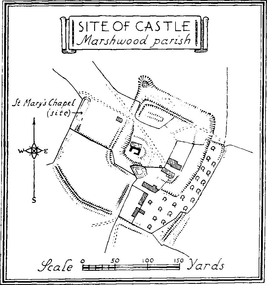
c(1) Marshwood Castle, earthworks and ruins, stands towards the S. side of the parish and nearly 2 m. S.E. of the modern church. It was the head of the barony of Mandeville of Marshwood. The Earthworks consist of a roughly rectangular moated enclosure with outer enclosures on the S. and parts of the E. and W. sides. The main enclosure has remains of an inner rampart at the N.W. angle and along most of the N. side. The moat has been much filled up and is now only wet in two places; the rampart, at its highest point, rises 10 ft. above the present bottom of the ditch. In the S.W. angle is a mound or motte, now much damaged and rising about 8 ft. above the level of the enclosure. On it stand the remains of a rect-angular Tower (40 ft. by 29¼ ft.) of coursed rubble, with internal quoins; the external face has been removed but the walls were from 6 to 10 ft. thick; there are remains of a former opening in the N. wall, which still stands to a height of 14 ft. In the N.W. angle of the enclosure are traces of the walls, uncovered in 1839, of the former Chapel of St. Mary, which seems to have been a building of about 24 ft. wide; it became ruined in the 17th century. There is an outer bank to the moat at the S.W. angle and the outer enclosures have remains of banks and ditches.

Site of Castle, Marshwood Parish
c(2) Barn, at Lodge House Farm, immediately S. of the moat of the castle, is a flint and rubble building, probably of late 17th-century date. It has a modern roof.
Monuments (3–15)
The following monuments, unless otherwise described, are of the 17th century and of two storeys; the walls are of rubble and the roofs, where old, are thatched. Several of the buildings have exposed ceiling-beams and original fireplaces.
c(3) Great Bluntshay, house, two tenements, 700 yards S.E. of the castle, has been much altered externally.
c(4) Little Dunster Farm, house 1¾ m. E. of the castle, has an 18th-century extension on the E. Two windows retain their original oak frames.
d(5) Filford Farm, house in the S.E. angle of the parish, has an 18th-century extension on the W.
c(6) Monkwood Farm, house nearly 1¾ m. E.N.E. of the castle, has been much altered.
c(7) Yard Farm, house ¾ m. N.W. of (6), retains an original doorway with a solid oak frame.
c(8) Hakeridge Farm (Plate 41), house 1 m. N.N.E. of the castle, has an early 18th-century wing on the N. and various later additions. The S. front retains an original doorway with a four-centred head and stonemullioned windows with labels. The N. wing has a stone with the initials and date R.E. 1707, and an original stone window reset. Inside the building is an original muntin and plank partition.
c(9) Purcombe (Plate 43), house 170 yards S.W. of (8), retains an original muntin and plank partition and two doorways with four-centred heads.
b(10) Higher Sminhay Farm, house ½ m. S.E. of the modern church, retains an original stone fireplace with moulded jambs and four-centred head.
b(11) Harmshay Farm, house 680 yards W.N.W. of(10).
a(12) Cottage, two tenements, on the W. side of the road at Marshalsea, ½ m. N.E. of the church.
a(13) Colmer Farm, house 700 yards N.N.W. of the church, retains some original oak window-frames and one stone-mullioned window with a label. Inside the building, one room has moulded ceiling-beams, perhaps reused. An iron fire-back bears the date 1650.
b(14) Nash Farm, house 1,050 yards S.W. of the church, was built in the 16th century but has a 17th-century addition on the S.E. and an 18th-century wing on the N. The house retains some stone-mullioned windows. Inside the building there is a plank partition (Plate 51) and the W. part of the house has panelled open ceilings with original moulded beams and plates.
c(15) Valehouse Farm, house 1½ m. S.S.E. of the church, has an original stone doorway with a segmental head.