An Inventory of the Historical Monuments in Dorset, Volume 2, South east. Originally published by Her Majesty's Stationery Office, London, 1970.
This free content was digitised by double rekeying. All rights reserved.
'Bincombe', in An Inventory of the Historical Monuments in Dorset, Volume 2, South east(London, 1970), British History Online https://www.british-history.ac.uk/rchme/dorset/vol2/pp22-24 [accessed 30 April 2025].
'Bincombe', in An Inventory of the Historical Monuments in Dorset, Volume 2, South east(London, 1970), British History Online, accessed April 30, 2025, https://www.british-history.ac.uk/rchme/dorset/vol2/pp22-24.
"Bincombe". An Inventory of the Historical Monuments in Dorset, Volume 2, South east. (London, 1970), British History Online. Web. 30 April 2025. https://www.british-history.ac.uk/rchme/dorset/vol2/pp22-24.
In this section
4 BINCOMBE (6884)
(O.S. 6 ins. aSY 68 SE, bSY 68 NE, cSY 78 SW, dSY 78 NW)
The present parish of Bincombe covering about 2,850 acres lies midway between Dorchester and Weymouth on the S. side of the S. Dorset Ridgeway. The N. part, on Chalk, slopes S. from the crest of the Ridgeway at over 500 ft. above O.D. This gentle slope is cut short by a steep escarpment caused in part by the so-called Ridgeway Fault. S. of this fault the parish slopes S. from about 350 ft. to about 75 ft. above O.D. on Kimmeridge Clay, except where outcrops of the harder Portland and Purbeck Beds have produced small hills, as at Chalbury, Tout and the Knoll.
There have been considerable readjustments to the parish boundaries in the 20th century involving losses on the S. and W. to Weymouth and gains on the E. from the former parish of Preston, including part of Sutton Poyntz, and on the N.W. from the former parish of Upwey.
Bincombe village, the original and still the only settlement in the parish, lies in a deep valley draining S.E., immediately below the Chalk escarpment. The open fields were enclosed in 1827 and extensive remains of these, and of those of Sutton Poyntz, still exist.
The parish contains a large number of barrows and a rare form of 'Celtic' fields. The church and Chalbury hill-fort are the principal monuments.
Ecclesiastical
a(1) Parish Church of the Holy Trinity stands at the S. end of the village. The walls are of rubble with freestone dressings and the roofs are covered with slates and stone tiles. The Chancel and Nave were built late in the 12th century, but of the former the S. wall was rebuilt in the 15th century and the E. end in the late 19th century. The N. wall of the nave was rebuilt and the S. wall heightened in the 15th century, the heightening being demarcated by a weathered offset, and the West Tower was added at the same time. The South Porch was built in the 17th century but incorporates older materials. The church was extensively restored in 1862.
Architectural Description—The Chancel (21 ft. by 13½ ft.) has a late 19th-century E. wall and window. In the N. wall are traces of a blocked window probably of the 12th century; further W. is a small square-headed window, now blocked. In the S. wall are two partly restored 15th-century windows, each of two trefoiled lights in a square head with moulded reveals and label. The reconstructed late 12th-century chancel arch is two-centred and of two orders chamfered on the W. and chamfered and square on the E.; the responds have each an attached half-round shaft with moulded capital and base with spur-ornaments.
The Nave (32 ft. by 17 ft.) has, in the N. wall, two modern windows and high up at the W. end an opening, now blocked, which perhaps lit a former gallery. The 17th-century N. doorway, also blocked, has chamfered jambs and rounded head; above it are traces of the roof of a former porch. In the S. wall are two much restored 15th-century two-light windows with square heads and labels; the S. doorway is 17th-century, restored; high up at the E. end of the wall is a square-headed opening to light the former rood loft but now blocked.
The West Tower (about 9 ft. square) is of the 15th century and of two stages with a parapet. The tower arch is two-centred and of two continuous chamfered orders. The W. window is of two trefoiled lights with blind spandrels in a square head. Higher up in the W. wall is a small rectangular window. The bell chamber has, in each wall, a two-light window similar to the W. window.
The South Porch (8 ft. by 8½ ft.) is of the 17th century with older material reused, including the outer archway with jambs and two-centred arch of two chamfered orders.
The Roofs have been renewed; the chancel is ceiled in plaster; in the nave are plain king-post trusses.
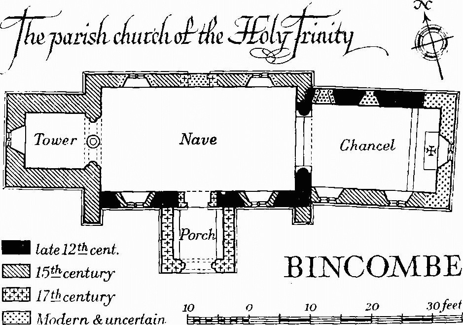
The Parish Church of the Holy Trinity, Bincombe
Fittings—Bells: two, 1st by Thomas Purdue, 1658, 2nd by John Wallis of Salisbury, 1594 (Raven, 61). Door: in S. doorway, ledged, with strap-hinges and inscription, W.L. C.W. 1779 W.M. Font: round bowl of Purbeck stone with chamfered under edge and remains of fastening for lid, 13th-century, stem modern. Monument: in churchyard—S. of porch, to Peter Day, 1708, headstone. Plate: includes a cup of 1662 (?) with the maker's mark I.G., and a paten of 1843 given by the rector, Thomas Dade. Stoup: in nave—by S. doorway, recess with pointed head and rounded bowl, the latter in part broken away, mediaeval. Sundial: on E. jamb of S.W. window of chancel, scratch dial, mediaeval.
Secular
The houses in the parish unless otherwise described are of one storey with attics, rubble-built and with roofs now tiled.
a(2) House (50 yds. S.W.) was built in the late 16th century on a plan comprising a hall and inner room. The hall fireplace had chamfered stone jambs and a timber four-centred head; it had a winding staircase beside it and the two occupied the full width of the N.E. end of the building. The attics were originally open to the roof, which had trusses of jointed-cruck type. At different times in the 18th century a cottage was added to each end and a wing at the back. In 1956 the 16th-century house had fallen into ruin revealing ancient plasterwork painted with a fleur-de-lys pattern. (Demolished)
a(3) House (170 yds. N.W.), of two storeys, was built in the 17th century. It has an end fireplace in each of the two ground-floor rooms and two chamfered ceiling beams, now plastered. The windows have stop-chamfered timber lintels. The roof is of collar-beam type, the common rafters being pegged to the purlins. Set in the upper front wall are two carved stones, perhaps corbels, of the 14th or 15th century. One depicts a standing figure with sword and shield, the other a seated figure.
a(4) Cottage (just N.), of two storeys with a tiled roof, was built in the 18th century. It was an addition to a cottage on the W. built in the 17th or early 18th century and which was demolished between 1950 and 1956.
a(5) Bincombe Marsh Dairy (683836), of two storeys and attics, was built in the late 18th century. The plan comprised two rooms and an outhouse at the back with a lean-to roof. On the W. is a modern addition. One of the two fireplaces has an original bread oven.
The following barns (6–9) were built in the second quarter of the 19th century; they are of rubble with slated roofs and of almost identical size and plan (see plan p. lxvi).
b(6) Barn (675851), at Lower Bincombe Farm, is dated by a stone in the W. gable inscribed 'C 1827'; C is for Caius College, Cambridge. The barn is nearly 58 ft. long and 18½ ft. wide inside, with a porch on the N. side 12½ ft. wide and projecting 11 ft. (plan p. lxvi). On the S. side, opposite the porch, are double doors; a stone threshing floor crosses the barn. The roof is half-hipped and the trusses have bolted tie and collar beams.
a(7) Barn (600 yds. N.E.) has a stone inscribed 'C 1826' (see Monument 6). The threshing floor is of wood.
a(8) Barn (130 yds. S.W.) has one rounded corner.
b(9) Bincombe Barn (677858) is probably slightly later than the dated examples described above; it has a small subsidiary porch, which is flanked by original outhouses with lean-to roofs.
b(10) Bayard Barn (670866), standing in an outlying portion of the parish transferred from Upwey, has walls of stone and a roof, now of corrugated iron, formerly thatched; it was built in the early 19th century.
Earthworks, Etc.
Mediaeval and Later Earthworks
a, b(11) Strip Fields (Figs. pp. 24, 484; Plates 70, 72, 216). Remains of strip cultivation in Bincombe and Sutton Poyntz are widespread; in outlying places this cultivation may have altered earlier field patterns (e.g. on Bincombe Hill, see Ancient Field Group (8)). Much has been destroyed by quarrying but the present obvious remains are complemented by slight traces visible on air photographs or from the ground. The position of outcropping rock in risers suggests that some of the strip lynchets were deliberately constructed for at least part of their length. Treads generally slope downwards in cross section, with interesting exceptions in Coombe Bottom furlong, and their ends are ramped, 'drawnout' or quarter-round. The open fields of Bincombe were finally enclosed in 1827 when South Field lay S. of the village, Middle Field was immediately S. of Bincombe Down and North Field lay just N. of Bincombe Hill. Faint traces of strip-field remains in the former Middle and North Fields are visible on air photographs. Almost all the strip fields remaining were cultivated at least into the 19th century but are now mostly in pasture. (R.A.F. V.A.P. CPE/UK 1821: 4453, 6445–7; Enclosure Maps of Preston and Sutton Poyntz, 1794, and of Bincombe, 1827, in D.C.R.O., show furlong names (see plan p. 24).)
(a) Strip lynchets of the former Bincombe parish cover some 60 acres S.W. and S.E. of Lower Bincombe Farm (around 675850) and S.E. of the village (around 688840 and 686835; Plate 70). In the former South Field two blocks make a butt junction at right angles and a series curves S.E. to the line of the former parish boundary with Preston and Sutton Poyntz, which in 1794 ran in zigzags. At 68848400 an isolated strip lynchet curves uphill and E. as if to avoid a hollow, probably an ancient quarry. Widths of treads vary from 4 yds. to 18 yds. and riser heights from 3 ft. to 16 ft. Limestone is seen outcropping in the faces of some risers (cf. on Green Hill, below). Many treads are overlaid with narrow rig. A mound (75) has been trimmed by strip cultivation S.E. of Lower Bincombe Farm.
(b) Strip lynchets formerly in Sutton Poyntz cover some 45 acres E. and S.W. of Green Hill (around 695843) and N., W. and S.W. of Chalbury (around 694838) (Plates 72, 216). Cement-stone outcrops in the faces of risers at the valley head E. of Green Hill and at the foot of Tout on the S.E. suggest artificial construction of the strip lynchets (Plate 70). On Green Hill the treads are also so spaced vertically that slivers of natural ground can be seen in places between them. In this area strip lynchets run into each other at the obtuse angle of the valley head. Strip lynchets with flat treads are curiously carved at wide intervals into the E.-facing slopes of Coombe Valley, about 692841. Around 687834 a block runs in a shallow S curve, probably due to the contours, up to the former parish boundary and must have been contiguous with those in Bincombe. Widths of treads vary from 5 yds. to 9 yds. and riser heights from 3 ft. to 18 ft. Immediately N.E. of Chalbury (about 695840) shallow strip lynchets continue up a slope of 20°. On the upper slope dividing banks 9 ft. across are apparently original. For fields further E., see Weymouth (395).
Other Earthworks and Allied Monuments
(12) Long Barrow, p. 431.
(13–74) Round Barrows, p. 437.
(75) Mound, p. 481.
(76) Chalbury, hill-fort, p. 486.
Roman Road, p. 528.
(77) Roman Burial, p. 594.
Ancient Field Groups (7, 8), p. 627.
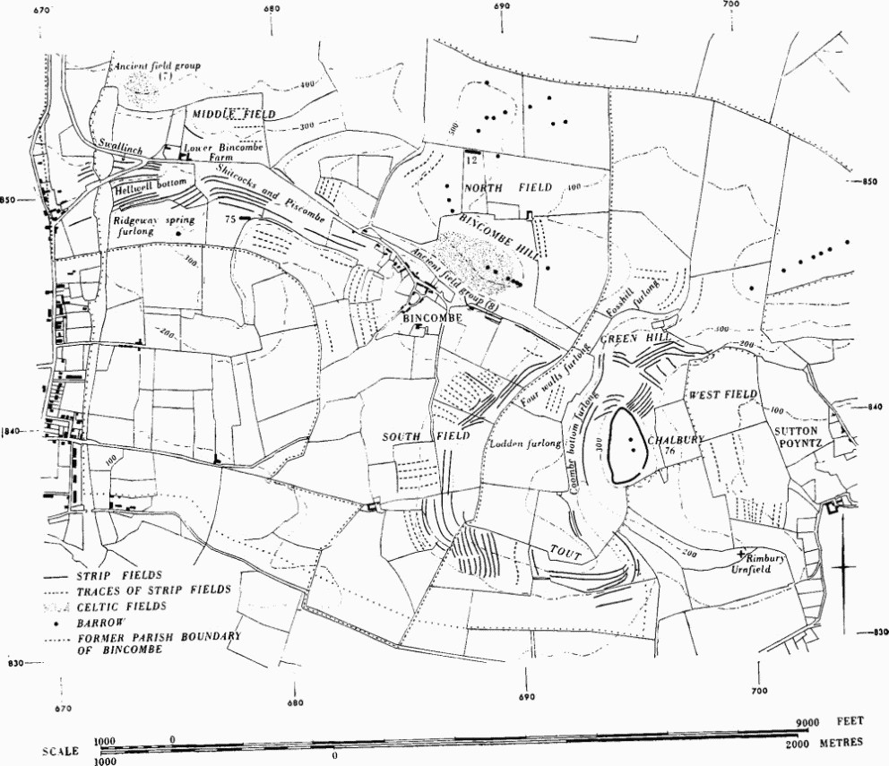
Bincombe (11) and Weymouth (395). Strip fields in Bincombe and Sutton Poyntz.