An Inventory of the Historical Monuments in Dorset, Volume 2, South east. Originally published by Her Majesty's Stationery Office, London, 1970.
This free content was digitised by double rekeying. All rights reserved.
'Earthworks: Round Barrows', in An Inventory of the Historical Monuments in Dorset, Volume 2, South east(London, 1970), British History Online https://www.british-history.ac.uk/rchme/dorset/vol2/pp434-480 [accessed 30 April 2025].
'Earthworks: Round Barrows', in An Inventory of the Historical Monuments in Dorset, Volume 2, South east(London, 1970), British History Online, accessed April 30, 2025, https://www.british-history.ac.uk/rchme/dorset/vol2/pp434-480.
"Earthworks: Round Barrows". An Inventory of the Historical Monuments in Dorset, Volume 2, South east. (London, 1970), British History Online. Web. 30 April 2025. https://www.british-history.ac.uk/rchme/dorset/vol2/pp434-480.
In this section
Round Barrows: Inventory
Affpuddle
All but three of the twenty barrows in the parish lie on the heathlands rising to the N. of the River Frome. Most have been damaged by recent military activity. Two are probably bells, one within group (A). Barrows (61–3) lie on chalk N. of the River Piddle.
(A) Pallington Heath Group (SY 79 SE). Eight barrows, including one probable bell, immediately S. of Piddle-Frome watershed, near S. edge of broad flat plateau just above 300 ft. contour.
(44) Bowl (78739219) at Pallington Clump. Diam. 70 ft., ht. 7½ ft. Surrounded by tree-clump circle; still prominent with pines.
(45) Mound, possible bowl (78769217), 32 yds. E. of (44). Diam. 20 ft., ht. 2 ft. Damaged.
(46) Bell (?) (78799222) 80 yds. E.N.E. of (44). Diam. 63 ft., including berm on N., ht. 8½ ft., ditch 7 ft. wide and 1 ft. deep.
(47) Bowl (?) (78789223) immediately W.N.W. of (46). Diam. about 20 ft., ht. 1½ ft.
(48) Ditched bowl (78919224) 135 yds. E.N.E. of (46). Diam. 50 ft., ht. 5½ ft. Road cuts N. side.
(49) Bowl (78969222) 50 yds. E.S.E. of (48). Diam. 54 ft., ht. 4½ ft.
(50) Bowl (79089212) 175 yds. S.E. of (49). Diam. 54 ft., ht. 4¾ ft.
(51) Ditched bowl (79109214) 25 yds. N.N.E. of (50). Diam. 37 ft., ht. 4½ ft. Excavated in centre and across E.-W. axis.
(52) Bowl (SY 79 SE; 79709251) in Sares Wood on gentle N. slope just under 300 ft. above O.D. Diam. 43 ft., ht. 3½ ft. Planted with firs.
(53) Bowl (?) (SY 79 SE; 79969226) on edge of plateau just above 300 ft. contour. Diam. 30 ft., ht. 1½ ft. N. half destroyed.
(54) Bowl (SY 89 SW; 80079226) situated as (53) and 125 yds. E. of it. Diam. 26 ft., ht. 1¾ ft. Practically destroyed.
(55) Bell (?) (SY 89 SW; 80539236) on plateau above 200 ft. contour. Diam., including berm, 52 ft., ht. 5½ ft., with ditch 8 ft. wide and 1 ft. deep. Much damaged.
(56) Ditched bowl (SY 89 SW; 80679227) on edge of spur jutting S. from plateau and 175 yds. S.E. of (55). Diam. 45 ft., ht. 5 ft.
(57) Bowl (SY 89 SW; 81399246) on S. edge of plateau 60 yds. S. of Cull-pepper's Dish, a swallow-hole. Diam. about 51 ft., ht. 3 ft. Much damaged.
(58) Bowl (SY 89 SW; 81499243) on S. edge of plateau 100 yds. E.S.E. of (57). Diam. 26 ft., ht. 3 ft. Hollowed on top.
(59) Ditched bowl (SY 89 SW; 81739199) on E. knoll in Starmoor Plantation inside 200 ft. ring contour. Diam. 32 ft., ht. 2½ ft.
(60) Bowl (SY 89 SW; 82499241) in Throop Clump just above 200 ft. contour and on gradual S. slope. Diam. 62 ft., ht. 8½ ft. Damaged.
(61) Double Barrow, bowl (SY 89 SW; 82089453) on 300 ft. contour near W. end of spur. Diam. about 40 ft., ht. about 8 ft. No evidence of contiguous barrow.
(62) Rewbarrow (1811), bowl (?) (SY 89 SW; 81849456). On ground falling S. to 200 ft. contour. Diam. about 30 ft., ht. 5 ft.
(63) Bowl (SY 89 NW; 81899538) below crest of broad S.-facing spur above 200 ft. contour. Diam. 39 ft., ht. 3 ft. In area of very disturbed 'Celtic' fields. Ploughed.
Arne
Nineteen barrows are scattered irregularly over the parish, all on Tertiary Beds and mostly in heathland. Six, together with three now in Wareham Lady St. Mary, form a group (B) on Worgret Heath, while (42–44) lie very close together on Middlebere Heath. Many are damaged and one (LVG 12), has been destroyed. Three have been excavated: King's Barrow (36) covered a rare example of a tree-trunk coffin burial; one, unidentified, contained an urn cemetery; the third, a small unidentified site near (36), was opened in about 1835 and twenty-five bronze axes, at least two apparently socketed, were found (Hutchins I, 100; Dorset Procs. XX (1899), 159).
(28) Bowl (SY 88 NE; 89658729). Diam. about 55 ft., ht. 4 ft. Ploughed.
(B) Worgret Heath Group (SY 98 NW), nine barrows, including Wareham Lady St. Mary (82–4) of which (83) is a possible bell. On relatively high ground around the 100 ft. contour, though (31) is below it to the E. One barrow in this area, excavated in c. 1830 by Pennie and later destroyed, contained at least twenty-four Middle or Late Bronze Age urns, some holding cremations. Only one survives, in D.C.M. (Gentleman's Magazine (1838), pt. i, 303; Hutchins I, 108).
(29) Ditched bowl (90028707). Totally excavated 1964 by Dr. G. J. Wainwright for the Ministry of Public Building and Works. Diam. 40 ft., ht. 4 ft., surrounded by a ditch 10 ft. wide. Near the centre of the mound were a biconical urn and a bucket urn but no burial (Dorset Procs. LXXXVII (1965), 119).
(30) Bowl (?) (90258701) 240 yds. E.S.E. of (29). Diam. about 40 ft., ht. about 4 ft. Converted into tree-covered and revetted garden feature.
(31) Ditched bowl (90538709) 330 yds. E.N.E. of (30) on summit of ridge. Diam. 65 ft., ht. 8½ ft. Top flattened and slightly hollowed. Ditch recently widened. Fir-covered.
(32) Ditched bowl (90118720) 175 yds. N.N.E. of (29) on end of spur. Diam. 20 ft., ht. 2½ ft.
(33) Ditched bowl (90128733) 150 yds. N. of (32). Diam. 40 ft., ht. 4½ ft., with ditch 6½ ft. wide and up to 9 ins. deep.
(34) Bowl, possibly ditched (90138736) 38 yds. N.N.E. of (33). Diam. 32 ft., ht. 5 ft. Cut by modern field boundary.
Wareham Lady St. Mary:
(82) Bowl (90238727) 155 yds. S.E. of (34) near edge of slope falling steeply N. Diam. about 50 ft., ht. 5 ft.
(83) Ditched bowl or bell (90308724) 76 yds. E.S.E. of (82). Diam., including possible berm on N., 61 ft., ht. 6½ ft., with ditch 7 ft. wide and 1 ft. deep cut by modern ditch on S. Disturbed on top.
(84) Ditched bowl (90328727) 50 yds. N.E. of (83) at end of spur. Diam. 38 ft., ht. 5½ ft., with ditch 6½ ft. wide and up to 1 ft. deep.
(35) Ditched bowl (?) (SY 98 NW; 91648571) in Bartletts Firs. Diam. about 60 ft., ht. 9 ft. Covered in rhododendrons.
(36) King's Barrow, bowl (?) (SY 98 NW; 92048572). Now in a garden and covered with trees and shrubs. Diam. uncertain, ht. about 5½ ft. In 1767 said to be 100 ft. in diam., 12 ft. high and apparently constructed of turves. In centre on sandy buried surface was primary inhumation (probably Wessex culture) without skull, wrapped in stitched animal skins, within a hollowed oak tree coffin 10 ft. long by 4 ft. wide by 3 ft. deep orientated N.W.-S.E. Attached to one skin was 'gold lace' 4 ins. by 2½ ins. with 'bits of wire' in it. Near the S.E. end of the coffin was a small cup, now lost, 2 ins. high, at most 3 ins. in diam. at the rim, with sides only 1/5 in. thick, and decorated with incised lines. Though described as of oak, it was more probably made of Kimmeridge shale. (Salisbury Journal 9th Mar. 1767; Gentleman's Magazine (1767), 53–4; Hutchins I, 100, 563; W.A.M. XLIV (1928), 101–5 and 111–17; P.P.S. XV (1949), 101–6.)
(37) Three Lords' Barrow, bowl (?) (SY 98 SW; 91458475) at junction of four parishes and formerly at junction of three manors. Diam. about 45 ft., ht. 3 ft., on natural knoll with stream to S. and W. A piece of stone window jamb on top presumably serves as boundary mark.
(38) Bell (?) (SY 98 SW; 92178469) on slight rise immediately inside modern tree-clump enclosure. Diam. including slight, sloping berm 65 ft., ht. 7 ft. Top flattened and disturbed.
(39) Bowl (SY 98 SW; 92988450) on almost level site and crossed by parish boundary with Church Knowle. Diam. 54 ft., ht. 4½ ft. Dug into on top.
(40) Bowl (SY 98 SW; 93078466). Diam. 65 ft., ht. 8 ft. Excavation in centre and on E.
(41) Bowl (SY 98 SW; 93078481) on almost level site. Diam. 55 ft., ht. 5½ ft.
The Three Barrows (SY 98 SW) lie in an E.-W. line within 100 ft. ring contour on S.W. of Middlebere Heath. All are badly damaged.
(42) Ditched bowl (93898441). Diam. 84 ft., ht. 6½ ft., with ditch about 10 ft. wide. Possibly contiguous with (43).
(43) Bowl (?) (93918441) immediately E. of (42). Ht. about 6 ft.
(44) Bowl (?), large (93948441), 25 yds. E. of (43).
(45) Mound, possible small bowl (SY 98 NW; 94778514), on O.S. 1811. Crossed by boundary bank.
(46) Ditched bowl (SY 98 NE; 96928815) on ridge summit. Diam. 95 ft., ht. 9½ ft., with ditch 14 ft. wide and 1½ ft. deep. An outer bank is possibly a tree-clump enclosure. Damaged.
Bere Regis
The parish contains fifty barrows, on heathland to the S. and on downland, now largely arable, to the N. The heathland barrows are usually widely spaced; those on the downland are more numerous and often in clusters or groups. The six barrows in the Roke Down group include two probable bells; the three clustered in the E. of the parish include one (114) with two concentric ditches. On Broomhill is a good example of a small linear group (C). 'Barrow Hill' immediately N. of the village is natural, as are probably the 'tumuli' (LVG 13 and 14) on Lower Hyde Heath.
The parish has an unusual number of named barrows; many, including some now destroyed and forgotten, e.g. Muddox barrow (about 852966), are shown on an estate map of 1777 by I. Taylor (in D.C.R.O.).
Confused accounts exist of six 19th-century excavations of barrows in the Roke Down area (see Group (D)). Four barrows on 'Kingston Down' were excavated in 1850; the first three were perhaps (107), (106) and (109) since they were probably on Bere Down, not in Winterborne Kingston. The first (Warne, C.T.D., cpf, no. 9) contained an apparently central deposit of two urns, one associated with a piece of green sandstone under burnt matter. Apparently to one side and above this layer were a contracted inhumation and three separate cremations, each burial covered by a flint cairn. In the top of the mound were remains of a large urn with three perforated lugs and immediately below the surface on the S.E. was a probable beaker. Warne's no. 10 (C.T.D., cpf), S.W. of the first, contained a central, probably primary, cremation in an inverted urn, two secondary cremations on the S.E. and a large fragmentary urn on the E. This second urn, with a finger-printed shoulder cordon and horse-shoe handles, contained a bead of rolled sheet bronze like that from the Roke Down Group, though much smaller (Abercromby II, 39 and fig. 374; Butler and Smith, 33). The third barrow (Warne, C.T.D., cpf, no. 11) contained, in a small cist covered with flints, a primary cremation in a globular urn. Above was a cremation and in the top of the mound a third cremation in an inverted urn covered by a sandstone slab. Warne's no. 12 (C.T.D., cpf), S.E. of the others and only a very low mound, covered seven extended inhumations, their heads to the E., in a grave cut about 1 ft. into the chalk and covered by a layer of flints. Some of the urns from these barrows are in the B.M. (Ant. J. XIII (1933), 443).
(67) Bowl (SY 88 NE; 86168926) on South Heath above 100 ft. Diam. 55 ft., ht. 7 ft. Damaged by tanks.
(68) Bowl (SY 88 NE; 86208924) 35 yds. S.E. of (67). Diam. 58 ft., ht. 7 ft. Possibly ditched. Damaged by tanks.
(69) Bowl (SY 89 SW; 84329102) on flat summit of Gallows Hill above 200 ft. Diam. 58 ft., ht. 5½ ft. Damaged by tanks.
(70) Bowl, possibly ditched (SY 89 SE; 85489100) on S.-facing slope of narrow valley above 100 ft. Diam. 46 ft., ht. 3 ft. Hollowed on top.
(71) Fox Barrow (1777), ditched bowl (SY 89 SE; 86259228). On Philliols Heath on W. slope of low ridge. Diam. about 54 ft., ht. about 7½ ft. Ditch 7 ft. wide and 2 ft. deep. Thickly overgrown.
(72) Bowl (SY 89 SE; 86219290) on W. slope above steep fall, 150 ft. above O.D. Diam. about 30 ft., ht. 3 ft. Thickly overgrown.
(73) Yon Barrow (Yarn Barrow, 1777), ditched bowl (SY 89 SE; 86379294). Above 150 ft. on Lockyer's Hill at top of steep W. slope. Diam. 45 ft., ht. 8 ft. Planted with conifers.
(74) End Barrow, bowl (SY 89 SW; 84609310). On level ground below 150 ft. Diam. 57 ft., ht. 8½ ft. Thickly overgrown.
(75) Bell (?) (SY 89 SW; 84059370) at Blackhill Clump on S. end of ridge above 300 ft. and on parish boundary with Turners Puddle. Diam. of mound 62 ft., ht. 5 ft., with berm (?) and ditch; outer bank 110 ft. in diam., destroyed on S.W., probably a tree-clump enclosure.
(76) Hundred Barrow, bowl (SY 89 SW; 84469378). On summit of small spur above 200 ft. Diam. 58 ft., ht. 7 ft. Damaged by rabbits. Perhaps site from which Barrow Hundred named (Fägersten, 166).
(77–8) See Black Hill Group (X), Turners Puddle, p. 454.
(79) Bowl (SY 89 SW; 83539444) on narrow col above 300 ft. Diam. 61 ft., ht. 3½ ft. Damaged by tanks.
(80) Bowl (SY 89 SW; 83459448) on crest of narrow ridge 95 yds. N.W. of (79) and on parish boundary with Turners Puddle. Diam. 45 ft., ht. 3 ft. Damaged on E. by boundary bank and ditch.
(81) Bowl (SY 89 SW; 83299493) E. of and slightly below summit of ridge S. of Shitterton Wood. Diam. 33 ft., ht. 1½ ft.
(82) Stand Barrow (1777), bowl (SY 89 NW; 84289531). On summit of small knoll. Diam. 57 ft., ht. 1 ft. Ploughed.
(83) Barrow (?) (SY 89 NE; 85949507) in arable on summit of low wide ridge above 300 ft. Circular soil-mark at least 50 ft. across on vertical air photograph CPE/UK 1934: 4125.
(C) Broomhill Group (SY 89 NE), four bowls in an irregular line on the crest of a spur jutting E. from Woodbury Hill above 300 ft. All tree-covered and damaged.
(84) (86329508). Diam. 30 ft., ht. 4 ft.
(85) (86359509) 30 yds. E.N.E. of (84). Diam. 40 ft., ht. 5 ft.
(86) (86389509) 35 yds. E. of (85). Diam. 53 ft., ht. 7½ ft.
(87) (86419506) 50 yds. S.E. of (86). Diam. 45 ft., ht. 5 ft.
(88) Bowl (SY 89 NE; 86139539) in Bere Wood on level ground. Diam. 56 ft., ht. about 10 ft. Tree-covered.
(89) Bowl (SY 89 NW; 82539623) in arable on lower N. slope of ridge above 200 ft. Diam. 72 ft., ht. 3 ft. In Barrow Field (1777). Destroyed.
Bowls (?), three (SY 89 NW), on O.S. (1811), on Roke Down on crest and slopes of low rise above 200 ft. among Ancient Field Group (30). Nearly flattened by modern ploughing.
(90) (81919649). Diam. 55 ft. Apparently at 'Celtic' field angle.
(91) (81969648) 57 yds. E.S.E. of (90). Diam. 36 ft. Apparently at 'Celtic' field angle.
(92) (81999645) 40 yds. S.E. of (91). Diam. 54 ft.
(D) Roke Down Group (SY 89 NW), six barrows in two clusters of three, the westernmost including two probable bells. In arable on S. slopes of Down near 200 ft. contour; all except (96) among 'Celtic' fields with (93–5) probably at field angles (see Ancient Field Group (30)). All have probably been opened. Accounts exist of six excavations hereabouts but only one can be related with certainty to a specific barrow (97), though the account in Hutchins of even this is confused (Hutchins I, 143–4; Warne, C.T.D., cpf, no. 2 and 17 n.; Payne, Durden Catalogue (1892), 12–18; Abercromby II, 39 and fig. 375; Ant. J. XIII (1933), 443).
A barrow 'on the upper part of Roke Down' (LVG 46a; Warne, C.T.D., cpf, no. 2) contained a cremation, probably primary, in an inverted urn in a grave 3 ft. deep. In the mound near the centre were four cremations in bucket urns, of which three were inverted. Immediately above, three extended inhumations lay E.-W. and a similar inhumation, with a plain urn, came from the S. side of the mound. A sixth cremation, in a very small urn, lay just below the turf on the S.E.
A barrow (LVG 46b) a few yards to the E. contained two primary contracted inhumations. One lay in a grave 6 ft. long, 2 ft. wide and 2 ft. deep, accompanied by a cremation in a small 'drinking cup'. The other was in a grave about 5 ft. away with animal bones. In a layer of soil and charcoal 2 ft. thick at the base of the mound were four more inhumations and two 'drinking cups'. At least seven urns, three of them complete, accompanied or contained cremations higher in the mound. One complete biconical urn with applied horse-shoe handles and perforated lugs contained a bead of rolled sheet bronze; another a small bone pin.
In a third barrow (LVG 46c), a cremation, probably primary, with broken urn lay in a cist, near which were three further cremations and another urn. Four urns lay on the S. side of the mound and on the N.E. was an inhumation in a stone-lined grave. The fourth barrow (LVG 46d) contained three bucket urns, one with perforations on either side of a crack as if to bind it together. Some of the urns from these barrows are in the B.M. Warne also records the opening of a large barrow containing 'great stones . . . placed over the urns, similar to those in the Deverel Barrow'.
(93) Bell (?) (82099674). Diam. 80 ft., ht. 1½ ft. Ditch visible as crop-mark 14 ft. from base of mound.
(94) Bell (?) (82279684) 215 yds. N.E. of (93). Diam. 55 ft., ht. 9 ins. Ditch visible as crop-mark around N. half 9 ft. from base of mound.
(95) Ditched bowl (?) (82309674) 120 yds. S.S.E. of (94). Diam. 64 ft., ht. 1½ ft. Ditch visible as crop-mark at base of mound.
(96) Bowl (?) (82639669) 365 yds. E.S.E. of (95). Diam. 91 ft., ht. 2 ft.
(97) Bowl (82659683) 160 yds. N. of (96). A low rise 66 ft. in diam.; almost certainly the barrow excavated in 1840, by Wake Smart and later by Solly, and described as 4 ft. to 5 ft. high. Large sarsen blocks then lay on top; the sarsens now at the field edge were removed from the top of this barrow in about 1914. Primary burial (Wessex interment no. 4): probably cremation under inverted urn with an atypical ogival dagger (ApSimon, Appx. c, 40) and two knife daggers (all destroyed) at bottom of cist over 3 ft. deep. Three urns and 'several glass beads' previously found on E. (Hutchins I, 144; Warne, C.T.D., cpf, no. 21; Ant. J. XIII (1933), 443; ApSimon, 44 and 60.)
(98) Bowl (82709683) 55 yds. E. of (97) on centre of ridge and at 'Celtic' field angle. Diam. 57 ft., ht. 2½ ft.
(99) Bowl (SY 89 NW; 82579728) on E. slope of ridge above 200 ft. and overlooking small valley. Diam. 61 ft., ht. 2 ft. At foot of lynchet of Ancient Field Group (30). Ploughed.
(100) Bowl (SY 89 NW; 82879734) 330 yds. E.N.E. of (99) on opposite slope of valley and 160 yds. N.W. of long barrow Bere Regis (66). Diam. 66 ft., ht. 3 ft.
(101) Bowl (SY 89 NW; 83129714) on W. slope of ridge. Diam. 62 ft., ht. 1½ ft. Ploughed.
Three barrows (SY 89 NW) lie in a line ½ mile S.W. of Bere Down Buildings on the centre of a ridge above 200 ft. All are spread and almost destroyed by ploughing.
(102) Bowl (?) (83399668). Diam. 87 ft., ht. 1 ft.
(103) Bowl (83429662) 70 yds. S.S.E. of (102). Diam. 54 ft., ht. 6 ins.
(104) Bowl (83469659) 50 yds. S.E. of (103). Diam. 60 ft., ht. 6 ins.
(105) Oval mound, possible barrow (SY 89 NW; 83949707) on valley floor below 200 ft.; 60 ft. by 45 ft., ht. 9 ins. Much spread by ploughing.
(106) Bowl (?) (SY 89 NW; 83969724) 187 yds. N.N.E. of (105). Diam. 36 ft., ht. 1 ft. Much spread.
(107) Bowl (?) (SY 89 NW; 83989728) 35 yds. N.E. of (106) above 200 ft. Diam. 36 ft., ht. 1 ft. Much spread.
(108) Barrow (?) (SY 89 NW; 83979748) on gentle rise above 200 ft., 135 yds. N. of (107). Known only from unbroken circular crop-mark about 75 ft. in diam., visible on Cambridge University O.A.P. LR 85.
(109) Bowl (?) (SY 89 NW; 84199734) 240 yds. E.N.E. of (107) on lower slopes of valley between 200 ft. and 300 ft. Diam. 60 ft., ht. 1½ ft. Much spread.
(110) Bowl (?) (SY 89 NW; 84469730) on N.E. edge of Bere Down above 300 ft. and just below 'Celtic' field lynchet of Ancient Field Group (31). Diam. 41 ft., ht. 2½ ft. Much spread.
(111) Bowl (?) (SY 89 NW; 84449717) 145 yds. S.S.W. of (110). Destroyed.
(112) Hawks Barrow (1777), ditched bowl (SY 89 NW; 84349684). On flat-topped spur above 200 ft. contour and just below 'Celtic' field lynchet of Ancient Field Group (32). Diam. 74 ft., ht. 7 ft. Disturbed in centre. A collared urn in D.C.M. apparently came from this barrow (Dorset Procs. LXXXVI (1964), 115).
(113) Rawles Barrow (1777), bowl (?) (SY 89 NE; 85719621). On S.E. slope below 200 ft., adjoining hedge on W. side of road. Now low oval mound 99 ft. by 72 ft., and heavily ploughed.
A cluster of three barrows (SY 89 NE) lies on gentle slope to W. above 200 ft. contour and immediately inside parish boundary with Winterborne Kingston.
(114) Ditched bowl (86129635). Diam. 69 ft., ft. 1 ft. Two concentric ditches visible as crop-marks measure 31 ft. in diam. and 6 ft. wide (inner), and 70 ft. in diam. and 7 ft. wide (outer).
(115) Bolton's Barrow, ditched bowl (86099642), 80 yds. N.N.W. of (114). Diam. 80 ft., ht. 1 ft., with 12 ft. wide ditch visible as crop-mark.
(116) Barrow (?) (86179643) 97 yds. E.N.E. of (115). Visible only as crop-mark circle, diam. 66 ft.
Bincombe
All but three (72–4) of the sixty-two barrows in the parish form part of the Ridgeway Group. In the extreme N.W. of the parish, formerly part of Upwey, nine (13–21) form the E. part of the Ridge Hill Group (R.7) and about ½ mile S.E. of them a further nine mark the N. and E. edges of the Ridgeway Hill Group (R.8). The three groups described within the parish are on Bincombe Down (R.9) and Bincombe Hill (R.10), both including barrows in Winterborne Came, and on West Hill (R.12).
Many barrows certainly or probably in the parish have been excavated but few of the records can be related to visible remains. Conversely, several have clearly been dug into but cannot be related to the barrow diggers' descriptions. A barrow (Warne, C.T.D., tovp, no. 7) opened in 1784 on 'Bincombe Down on the Ridgeway' or 'on Ridgeway Hill' contained a probably primary cremation in one of two inverted urns, the other containing a three-riveted bronze dagger. Above were an inhumation beneath a flat stone, two urns with cremations, and, 3 ft. from the surface, an extended inhumation lying E.-W. In the same area four (Warne, C.T.D., tovp, no. 65) were opened in 1842: one contained two extended and probably intrusive inhumations and the others only revealed traces of burning. In 1842 a further four were excavated 'on Bincombe Down, on the Ridgeway'. One (Warne, C.T.D., tovp, no. 66), 3 ft. high, contained an (inverted ?) collared urn in the centre and two urns, one an inverted globular urn, side by side 2 ft. below the surface of the mound. In the second (Warne, C.T.D., tovp, no. 67), 'a quantity of bone was found scattered about, with large flat stones' and near the top two inhumations lay E.-W. side by side in a stone-lined cist. The third barrow (Warne, C.T.D., tovp, no. 68) was 12 ft. high and contained a central flint cairn, which was not excavated, and four inhumations near the top. The fourth (Warne, C.T.D., tovp, no. 69) was called a 'twin barrow' by the excavator, but probably only one mound was dug into. It contained two inhumations beside an upright stone and a cremation in an urn also containing a biconical 'incense cup' (for these last eight excavations see Cambridge Antiquarian Society, Procs. 1 (1859), 141–5). A small unlocated barrow near (22), excavated by Cunnington (MS., no. 34), contained an inurned cremation.
(13–21) See Ridge Hill Group (R. 7), Winterborne St. Martin, p. 468.
(22) Ditched bowl (SY 68 NE; 67248667). On spur running N.E. from Ridgeway below 400 ft. Ht. 4 ft.; air photograph (V.A.P. CPE/UK 1824: 3290) indicates ditch about 90 ft. diam. Opened by Cunnington in 1881, exposing burnt matter and bone fragments near the centre.
(23–31) See Ridgeway Hill Group (R.8), Weymouth, p. 456.
(32) Ditched barrow (?) (SY 68 NE; 67898609) suggested by circular ditch with small external bank about 100 ft. in diam. on air photograph (V.A.P. CPE/UK 1824: 3289).
(33) Bell (?) (SY 68 NE; 67918614) 60 yds. N. of (32). Diam. 90 ft., ht. 6 ft. Ditch about 115 ft. in diam. suggested by air photograph (V.A.P. CPE/UK 1824: 3289). Possibly contained a cremation in a chalk-cut cist.
Disc barrows (?), two (SY 68 NE), about 300 yds. N. of the Ridgeway (Ant. J. XIII (1933), 443; Helinium I (1961), 115).
(34) (68078625). On crest of slope to N., now only an indefinite mound 1 ft. high. It contained a primary cremation under an inverted bucket urn covered by a flat stone.
(35) (68098624) 20 yds. E.S.E. of (34) but now destroyed. It contained a primary cremation with a fragmentary bucket urn.
(R.9) Bincombe Down Group (SY 68 NE). Sixteen barrows, including two bells, partly on heath above the 500 ft. contour and scattered in three clusters. Two of them incorporate short straight alignments, which point towards two separate barrows at the W. end of the group. The top of the Ridgeway bends slightly to the N. at the E. end of the Down so that the Winterborne Came barrows on the S. of Came Down Golf Course lie on the true top of the ridge and directly continue the group. The short straight row (40–43) points towards bell barrow (38) 430 yds. to the W. and is sited on the beginnings of a steep slope to the S. Several barrows have been dug into and (40–3) have been ploughed nearly flat, but some on the Golf Course are relatively well preserved. It was probably into four of these last rather than into those in Came Down Group (AG) to the N. that Warne dug. One (C.T.D., mopr, no. 11) contained a central flint cairn over a chalk-filled cist. Close by was a large barrow (C.T.D., mopr, no. 12) over two flint cairns: the lower covered six inhumations, contained an inurned cremation, and was capped by a stone bearing carved concentric circles; the higher cairn was similarly capped. Two smaller, adjacent barrows (C.T.D., mopr, nos. 13 and 14), contained respectively a cremation in a globular urn and an extended inhumation. A barrow (Cunnington MS., no. 57) at the E. end of Bincombe Down contained a primary cremation and a secondary inurned cremation.
(36) Bowl (67838572). Diam. 38 ft., ht. 3 ft. Disturbed in centre.
(37) Bell (67978572) 120 yds. E. of (36). Diam. of flat-topped mound 88 ft., ht. above berm 10½ ft. The berm is 9 ft. wide and 1½ ft. above surrounding ground level within a ditch 23 ft. wide and 2 ft. deep. Much damaged.
(38) Bell (68028570) 75 yds. E.S.E. of (37). Diam. 65 ft., ht. 11 ft., with berm 8 ft. wide and ditch about 15 ft. wide and 1 ft. deep. Ploughed.
(39) Bowl (?) (68158578) 150 yds. N.E. of (38). Now only a slight rise. It probably contained cremations in four inverted Early-Middle Bronze Age collared urns in a cist beneath a cairn. There were two other similar urns, at least one of which was inverted, and two secondary urns (Abercromby II, figs. 5, 5a, 6c; Ant. J. XIII (1933), 444; P.P.S. XXVII (1961), 294, nos. 17–20).
Winterborne Came:
(10) Bowl (68428583) 307 yds. E.N.E. of the last, immediately above 500 ft. contour on slope to N. Diam. 54 ft., ht. 3 ft. Damaged by bunkers.
(11) Bowl (68468584). On centre of ridge running to N.E., 34 yds. E.N.E. of (10). Diam. 84 ft., ht. 10½ ft. Tree-covered and damaged on E.
(12) Bowl (68408588) 57 yds. N.W. of (11). Slight irregular rise 33 ft. in diam.
(13) Bowl (68438588) 24 yds. E.N.E. of (12). Diam. 33 ft., ht. 9 ins., but spread and cut by small ditch.
(14) Bowl (68468589) 19 yds. E.N.E. of (13). Diam. 39 ft., ht. 9 ins., but spread.
(15) Bowl (68498590) 25 yds. N.E. of (14). Diam. 54 ft., ht. 2 ft. Used as golf green.
(16) Bowl (?) (68578588) 90 yds. E. of (15) and off centre of ridge. Now an oblong mound 2½ ft. high used as tee.
(17) Barrow (68698577) immediately within W. edge of Came Wood 185 yds. S.E. of (16). Much overgrown and disturbed.
Bincombe:
(40) Bowl (?) (68428569). Diam. 60 ft., ht. 4½ ft.
(41) Bowl (?) (68468569). Ploughed flat.
(42) Bowl (?) (68508569). Ploughed flat.
(43) Bowl (?) (68539569). Ploughed flat.
(R. 10) Bincombe Hill Group (SY 68 SE, NE; Fig. p. 24). Twenty barrows, including a triple bowl and a bell, on one of the only two spurs jutting S. from the Ridgeway. The group is arranged in a rough semi-circle open to the E., curving along the domed top of the spur above the 500 ft. contour, and ending to the N.E. in Came Wood. To the S.E. it ends in a straight line of a triple bowl, a bell and two bowls (44–7), dramatically sited immediately to the S. of the highest point of the spur but visible on the skyline from many points and especially from the Broadmayne bank barrow. They are now preserved under grass among Ancient Field Group (8) (Fig. p. 627) but are damaged by central excavations.
Apart from four outliers, the group can be sub-divided into linear cemeteries of seven and eight barrows respectively at the S. and N. ends of the semicircle, with a long barrow (Bincombe (12)) and a bowl barrow roughly at the centre of the curve in the most westerly position. Most have been damaged by ploughing and now only appear as low, spread rises.
Some of the barrows excavated on the Ridgeway in Bincombe were possibly in this group. Warne's no. 43 (C.T.D., mopr) was probably the largest mound of the triple barrow (44) and his no. 6 (C.T.D., tovp), was almost certainly one of the others near it. In the former a primary cremation lay under an extended inhumation 8 ft. to 9 ft. below the top of the mound; two similar inhumations were about 2 ft. below the top of the mound, all three lying E.-W. in stone-lined graves. The latter contained a primary inurned cremation in a stone cist, above which were three extended inhumations. The group is described from the S. around the semicircle formed by the barrows.
(44) Triple bowl (69028458) aligned N.W.-S.E. immediately above 500 ft. contour. From W. to E. diams. and hts. of mounds are: 64 ft. and 8½ ft.; 68 ft. and 9 ft.; 67 ft. and 7 ft. There is no sign of a ditch around or between the mounds.
(45) Bowl (68988460) continuing alignment of (44) 25 yds. to the N.W. Diam. 69 ft., ht. 9 ft. Disturbed in centre.
(46) Bell (68948464) 68 yds. N.W. of (45). Diam. 92 ft., ht. 11 ft. Ditch 15 ft. wide and 2 ft. deep destroyed by ? ancient ploughing on S.E. The sloping berm, 9 ft. wide on S. and W., has been partly destroyed. Excavation hollow in centre.
(47) Ditched bowl (68918466) 48 yds. N.W. of (46). Diam. 100 ft., ht. 12½ ft. Ditch 10 ft. wide and 1 ft. deep.
(48) Bowl (69168465) 280 yds. E. of (47) on slight slope to N.E. below 500 ft. contour. Ploughed almost flat.
(49) Bowl (?) (68738493) 325 yds. N.N.W. of (47). Diam. about 65 ft., ht. 1 ft. Ploughed.
(50) Ditched bowl (?) (68748496) 46 yds. N.N.W. of (49). Diam. 90 ft., ht. 4½ ft.
(51) Bowl (?) (68748502) 65 yds. N. of (50). Diam. 90 ft., ht. 4½ ft.
(52) Bowl (?) (68978514) 290 yds. N.E. of (51) and 80 yds. E. of long barrow (12). Ploughed out.
(53) Bowl (?) (68888525) 150 yds. N.W. of (52) and 100 yds. N. of long barrow (12). Diam. 80 ft., ht. 7 ft.
(54) Bowl (?) (68918531) 70 yds. N.E. of (53). Diam 75 ft., ht. 5 ft.
(55) Bowl (?) (68958532) 38 yds. E. of (54). Diam. about 80 ft. Ploughed flat.
(56) Bowl (69008533) 50 yds. N.E. of (55). Diam. about 70 ft., ht. 2 ft.
(57) Bowl (?) (69108536) 120 yds. E.N.E. of (56). Diam. about 60 ft., ht. 1 ft.
(58) Bowl (?) (69198539) 100 yds. N.E. of (57). Diam. about 90 ft., ht. 3 ft.
Winterborne Came:
(18) Bowl (69298547) in Came Wood 145 yds. N.E. of last. Diam. 46 ft., ht. 4 ft. Flattened on top and damaged by excavation.
(19) Ditched bowl (?) (69338549) 50 yds. E.N.E. of (18). Diam. 76 ft., ht. 8 ft.
Bincombe:
(59) Bowl (?) (69208528) 120 yds. S. of (58). Ploughed out.
(60) Bowl (?) (69268528) 60 yds. E. of (59). Diam. about 80 ft., ht. 3 ft.
(61) Bowl (?) (68938546) 300 yds. W.N.W. of (58). Ploughed out. No other barrows lie between it, an outlier of the group, and alignment (40–3) to the W.
(R.12) West Hill Group (SY 78 SW). Ten barrows, nine of them, including one pond barrow (63), in a straight S.W.-N.E. alignment, lie about ¾ mile E.S.E. of the Bincombe Hill Group on a S.W. spur from the Ridgeway. All are exactly on the spine of the spur and are still visible on the skyline from the Broadmayne bank barrow (19), although seven have been heavily ploughed.
(62) Bowl (?) (70058453). At S.W. end of alignment just above 400 ft. contour. Diam. 54 ft., ht. 5 ft. Overgrown but unploughed.
(63) Pond barrow (70148459) 120 yds. N.E. of (62). Diam. 54 ft., depth 1 ft. within low bank about 25 ft. wide. Almost ploughed out.
(64) Ditched bowl (?) (70198462) 55 yds. N.E. of (63). Slight rise about 70 ft. in diam., with traces of original ditch on air photograph (V.A.P. CPE/UK 1821: 6444).
(65) Bowl (?) (70268464) 95 yds. N.E. of (64). Diam. 57 ft., ht. 2 ft.
(66) Bowl (?) (70328467) 65 yds. N.E. of (65). Diam. 57 ft., ht. 2 ft.
(67) Bowl (?) (70358468) 30 yds. N.E. of (66). Diam. 60 ft., ht. 2½ ft.
(68) Bowl (?) (70398470) 35 yds. N.E. of (67). Diam. 60 ft., ht. 2½ ft.
(69) Bowl (?) (70478473) 100 yds. N.E. of (68). Diam. 60 ft., ht. about 10 ft. Turf-covered.
(70) Bowl (?) (70528475) 50 yds. N.E. of (69). Almost ploughed out.
(71) Bowl (70588482) 110 yds. N.E. of (70). Diam. 78 ft., ht. 4½ ft.
(72) Bowl (?) (SY 68 SE; 67538484) in prominent isolated position just above 300 ft. contour on crest of The Knoll. Only slight mound remains.
(73) Ditched bowl (SY 68 SE; 69488389). Within Chalbury hill-fort (Bincombe (76); Fig. p. 484, Plate 216) above 300 ft. contour. Diam. 66 ft., ht. 5 ft. Probably opened by Warne, who found two inurned cremations in a cairn.
(74) Bowl (SY 68 SE; 69518384) 50 yds. S.S.E. of (73). Diam. 65 ft., ht. 4 ft.
Bloxworth
(E) Bloxworth Down Group (SY 89 NE). Fifteen barrows, including one disc or bell-disc, and comprising all the barrows in the parish, lie on a N. slope at the W. end of a chalk ridge between 170 ft. and 236 ft. above O.D.; (29) is on the highest point in the parish, and ten others cluster N. and E. of it. (40–3) are outliers to the N. Grinsell shows in addition two possible barrows in the group (3a and 7a on fig. 4 in Dorset Barrows). Two have been destroyed and all but (29) and (30) are badly damaged by ploughing, as are adjacent 'Celtic' fields (Group 33). (39–40) have been excavated. A third dug by Shipp in 1854 (Hutchins I, 184) might be (41), (42) or a barrow at about 87759595 (on O.S. 1811). It contained an apparently primary cremation with a bone pin 2 ins. long; two secondary cremations under inverted collared urns; a third, near the surface, beneath an inverted urn with a bone needle about 6 ins. long and, near it, six inhumations lying E.-W. The pin and four urns from Bloxworth Down are in the B.M., and a B1 beaker has also been recorded (Abercromby I, 22 and fig. 32).
(29) Bowl (87679619) in Higher Belt Coppice. Marked by trig. point at 236 ft. Diam. 48 ft., ht. 5 ft.
(30) Bowl (87709619) 35 yds. E. of (29). Diam. about 45 ft., ht. about 2½ ft.
(31) Bowl (?) (87699622) 40 yds. N.E. of (29). Diam. 60 ft., ht. 2 ft.
(32) Bowl (87689624) 25 yds. N.W. of (31). Diam. 45 ft., ht. 2 ft.
(33) Bowl (?) (87739623) 40 yds. E.N.E. of (31). Diam. 61 ft., ht. 2½ ft.
(34) Bowl (?) (87719624) 30 yds. N.W. of (33). Diam. about 30 ft., but ploughed almost flat.
(35) Bowl (?) (87699625) 25 yds. N.E. of (32). Diam. about 45 ft., but ploughed almost flat.
(36) Barrow (?) (87619629) 80 yds. N.W. of (35). Diam. about 55 ft., but ploughed almost flat.
(37) Barrow (?) (87649628) 20 yds. E.S.E. of (36). Diam. about 55 ft., but ploughed almost flat.
(38) Bowl (?) (87669626) 30 yds. E. of (37). Diam. about 45 ft., ht. about 1 ft.
(39) Disc or bell-disc (87709629) lying immediately E. of (38) and 50 yds. N.N.E. of (35). Mound formerly about 30 ft. in diam. and 4 ft. high, with berm, ditch and outer bank making total diam. 160 ft. (V.A.P. CPE/UK 1934: 4127); now only visible as slight rise. In c. 1854 Shipp found in a cist a primary cremation under an inverted collared urn also containing bone tweezers, eight amber beads and six or eight segmented faience beads, all now in B.M. (Wessex interment no. 5). In top of mound four inhumations, a woman, two children and a man, lay E.-W. (Hutchins I, 184; Abercromby II, 12 and fig. 49; Archaeologia LXXXV (1936), 235).
(40) Bowl (87679638) 110 yds. N.N.W. of (39). In 1854 diam. was 75 ft., ht. 8 ft. but now 1½ ft. Shipp found under a cairn an apparently primary cremation in a bucket urn with horse-shoe handles, now lost (Hutchins I, 184; Ant. J. XIII (1933), 444).
(41) Barrow (?) (87769647) 130 yds. N.E. of (40). Entirely destroyed.
(42) Bowl (?) (87529650) almost at foot of N. scarp of Down and 250 yds. W.N.W. of (41). Diam. 100 ft., ht. 5 ft., but badly damaged.
(43) Bowl (?) (87289651) on level site 260 yds. W.N.W. of (42). Diam. 67 ft., ht. 4 ft.
Broadmayne
The ten barrows in the parish (20–9) are all on the Ridgeway in Culliford Tree Group (R. 11), Whitcombe (p. 459), though another possibly existed on the boundary with Bincombe, S. of the group, at 70398513.
Chaldon Herring
Of the thirty-three barrows and probable barrows, fifteen fall into three small groups, one of them, the Beaufort Farm Group (G), very close to the present village. Two barrows, (38) and (39), are earlier than 'Celtic' fields around them (see Ancient Field Group (15), Fig. opp. p. 628).
Bowls, three (SY 78 SE), lie S.E. of Hill Barn on almost level summit of ridge overlooking sea.
(25) (77558114). Diam. about 35 ft., ht. about 9 ins. Almost ploughed out.
(26) (77578119) 67 yds. N.E. of (25). Diam. 54 ft., ht. 2½ ft.
(27) (77608116) 45 yds. S.E. of (26). Diam. 54 ft., ht. 2¾ ft.
(28) Bowl (SY 78 SE; 77888172) on N. slope below 500 ft. contour. Diam. 80 ft., ht. 2½ ft. Much damaged.
(29) Bowl (SY 78 SE; 77918102) on coastal ridge above 500 ft. Diam. 45 ft., ht. 5½ ft. Excavation trench across centre.
(30) Bowl (SY 78 SE; 77938102) 23 yds. E. of (29). Diam. 39 ft., ht. 4½ ft. Excavation trench across centre.
(F) Chaldon Down Group (SY 78 SE). Five bowls on flat summit of E.-W. coastal ridge.
(31) (78318142). Diam. 40 ft., ht. 7 ft. Diam. reduced by ploughing round base.
(32) (78378135) 100 yds. S.E. of (31). Ploughed almost flat.
(33) (78318125) 117 yds. S.W. of (32). Diam. 36 ft., ht. 5 ft. Destroyed W. of hedge crossing mound.
(34) (78388125) 63 yds. E. of (33). Diam. 55 ft., ht. 2 ft. Possible ditch on N.E.
(35) (78448126) 70 yds. E. of (34). Diam. 50 ft., ht. 1½ ft.
(36) Wardstone Barrow, bowl (SY 78 SE; 79348133). On N. shoulder of coastal ridge on site prominent from N. Diam. 44 ft., ht. 6 ft., but hollowed by excavation in 1867 which revealed, near the middle and on the original ground surface, a probably primary cremation in a bucket urn, now destroyed, covered by a flat stone (Dorset Procs. LXXVII (1955), 127–8). The barrow was probably at the angle of a 'Celtic' field.
(37) Barrow (?) (SY 78 SE; 79368133) about 22 yds. E. of (36). Diam. about 40 ft. In arable, and immediately above a 'Celtic' field lynchet.
(38) Mound, possible barrow (SY 78 SE; 79288094), on crest of spur falling S. from coastal ridge, some 450 ft. above O.D. Diam. about 21 ft., ht. 1½ ft. Spread, possibly excavated, it lies against the 'Celtic' field lynchet immediately above.
(39) Bowl (?) (SY 78 SE; 79278089) in similar position to and 45 yds. S. of (38). Diam. 36 ft., ht. 3½ ft. Earlier than adjacent 'Celtic' field lynchet. Spoil from central excavation thrown to S.
(40) Barrow (?) (SY 78 SE; 79638178) now destroyed.
(41) Barrow (?) (SY 78 SE; 79858182) now destroyed.
(42) Bowl (SY 78 SE; 79958163) on E. slope of ridge. Diam. 43 ft., ht. 5 ft. Much damaged.
(43) Bush Barrow, bowl (SY 78 SE; 79958199) on N.E. slope of ridge. Diam. 66 ft., ht. 7 ft. Tree-covered and damaged.
(G) Beaufort Farm Group (SY 78 SE). Four probable bowls strung along the very narrow spine of a low ridge just above the 300 ft. contour immediately N. of the village. All are in pasture.
(44) (79038358). Oval, 54 ft. (W.-E.) by 33 ft., ht. 4 ft.
(45) (79238358) 220 yds. E. of (44). Diam. 42 ft., ht. 2 ft.
(46) (79288359) 60 yds. E. of (45). Diam. 42 ft., ht. 2 ft.
(47) (79318361) 30 yds. N.E. of (46). Diam. 60 ft., ht. 4 ft.
(48) Lord's Barrow, bowl (?) (SY 78 SE; 77788412). On crest of ridge 400 ft. above O.D. Diam. 58 ft., ht. 7 ft. Crossed by parish boundary with Owermoigne. Excavated and much damaged.
(49) Barrow (?) (SY 78 SE; 77918415) in hedge on parish boundary with Owermoigne 167 yds. E. of (48). Diam. about 36 ft., ht. 1½ ft.
(50) Bowl (?) (SY 78 SE; 78698418). Diam. 41 ft., ht. 1½ ft. Disturbed in centre.
(H) The Five Marys Group (SY 78 SE). Six barrows, including two bells, shown as 'Five Meers' (boundary points) on I. Taylor's Map of Dorset, 1765. They lie in an almost straight line along the spine of a narrow W.-E. ridge above the 300 ft. contour some 300 yds. E. of (50). All are under pasture but damaged. Only one has not been dug into. A slight and very small depression with traces of a bank or spoil around it between (51) and (52) has been claimed as a probable pond barrow (LVG 4a). Two, possibly (51) and (53), excavated before 1866 by the exiled Duchess of Berry and suite, covered deep chalk-cut graves, each containing a contracted ('sitting') male inhumation with stag antlers on each shoulder; one also held a female skeleton with antlers similarly placed and the other contained a secondary inurned cremation in the upper part of the mound (Hutchins I, 346).
(51) Ditched bowl (78968421). Diam. 70 ft., ht. 10 ft. Ditch about 20 ft. wide and 3 ft. deep. Damaged by large excavation trench from N. and by hedge banks at base.
(52) Bell (79018421) 50 yds. E. of (51). Diam. 71 ft., ht. 8 ft., with sloping berm only 5 ft. wide and ditch 10 ft. wide and 1 ft. deep. Disturbed on top.
(53) Bell (79038421) adjacent to (52) on E. Diam. 56 ft., ht. 7 ft., with very narrow sloping berm and ditch 10 ft. wide and 1 ft. deep. Damaged by excavation trench from N.
(54) Ditched bowl (79078421) 30 yds. E. of (53). Diam. 56 ft., ht. 4 ft. with very narrow and shallow ditch. Centre of mound dug away and irregular mound immediately to W. is probably resultant spoil.
(55) Bowl (?) (79088421) immediately E. of (54). Diam. 24 ft., ht. 1 ft. Large flints showing in surface.
(56) Ditched bowl (79108420) 35 yds. E. of (54). Diam. 56 ft., ht. 7 ft. Ditch 10 ft. wide and 1 ft. deep. Excavation trench from N. with spoil on sides.
(57) Bowl (?) (SY 78 SE; 79288420) on crest of ridge 190 yds. E. of (56). Slight irregular mound about 1 ft. high.
Church Knowle
The fifteen barrows in the parish are divided between the chalk ridge of Stonehill Down and Knowle Hill to the S. and the heathlands at its foot to the N. A group of four lies on Creech Heath. Four have been excavated: (40) contained a primary contracted inhumation in a deep grave; (41) covered a probably secondary contracted inhumation above a primary cremation with a small dagger.
(35) Bowl (?) (SY 97 NW; 93597883) on broad ridge sloping slightly N. Diam. 30 ft., ht. 1½ ft., with many stones visible.
(36) Ditched bowl (SY 98 SW; 92108233) on end of spur above 600 ft. contour projecting S. from Creech Barrow hill, and crossed W. of centre by parish boundary bank with Steeple. Diam. 75 ft., ht. about 6 ft. Probably the barrow excavated by Austen, containing three primary contracted inhumations, one with a trepanned roundel from a child's skull, in a flint cairn; and two secondary extended inhumations. (Purbeck Papers I, 113–15; P.P.S. VI (1940), 112–32.)
(37) Ditched bowl (SY 98 SW; 92948226) on Stonehill Down above 400 ft. contour. Diam. 41 ft., ht. 5 ft. Top dug into.
(38) Bowl (?) (SY 98 SW; 93038230) on similar site to (37) 117 yds. E.N.E. of it. Diam. 15 ft., ht. 1 ft.
(39) Bowl (?) (SY 98 SW; 93168231) on Stonehill Down above steep E. slope below 400 ft. contour and 135 yds. E.N.E. of (38). Diam. 25 ft., ht. 1½ ft.
(40) Bowl (SY 98 SW; 94398238) on N. edge of Knowle Hill above 400 ft. contour, crossed by parish boundary with Corfe Castle on N. (Fig. opp. p. 509). Diam. 47 ft., ht. 4½ ft., in arable. Opened 1856 by Austen who found a central primary contracted inhumation in a chalk-cut grave, 8 ft. to 9 ft. in diam. and 9½ ft. deep, with antler, pottery and shale fragments in the chalk packing. Two contracted inhumations in stone cists lay 9 ft. W. and S.E. of centre; 2 ft. below top lay an extended inhumation protected by stones. Apparent overlap with cross-dyke (56e) on W. probably due to excavation spoil. (Purbeck Papers I, 110–15; Hutchins I, 595–6.)
(41) Ditched bowl (SY 98 SW; 94588236) on Knowle Hill 200 yds. E.S.E. of (40). Diam. 38 ft., ht. 3 ft. Twice opened, in 1861 and in 1934–5. Primary cremation with small tworiveted bronze dagger was in a grave 2½ ft. deep below a small mound. On top of this two inhumations, one contracted, were covered by a larger mound containing Middle and Late Bronze Age pottery within a ditch about 5½ ft. wide and 2 ft. deep. (Purbeck Papers II, 55–8; Dorset Procs. LXXVI (1954), 51–5.)
(42) Ditched bowl (SY 98 SW; 94588233) 40 yds. S. of (41). Diam. 45 ft., ht. 4½ ft. Opened 1861 by Austen who found a probably primary cremation in a cist below much burnt material containing a perforated whetstone now in D.C.M. (Purbeck Papers II, 55–8; Archaeologia XLIII (1871), 424–5, fig. 116).
(43) Bowl (SY 98 SW; 92558310) in Blackhills Plantation at E. end of spur above very steep slopes to N. and E. Diam. 45 ft., ht. 3 ft. (Dorset Procs. LXXIV (1952), 93).
(44) Ditched bowl (SY 98 SW; 92768311) in Blackhills Plantation 250 yds. E. of (43) on knoll above steep slopes to N. and N.E. Diam. 75 ft., ht. 9 ft., with flattened top and ditch 9 ft. wide and up to 2½ ft. deep.
(45) Icen Barrow, ditched (?) bowl (SY 98 SW; 92188385) on almost level site on Creech Heath. Diam. 56 ft., ht. 5 ft. Damaged. Bronze Age urn found in it (Dorset Procs. LXX (1948), 55).
(I) Creech Heath Group (SY 98 SW). Four barrows in a short straight W.-E. line above S. slope from slight ridge. Probably one of these, or perhaps (45), was built of turf and contained a probably primary cremation with a small, ruby-coloured object, possibly amber (LVG 5a; Warne, C.T.D., cpf, no. 43).
(46) Bowl (?) (92498402). Diam. about 40 ft., ht. about 3 ft. Almost destroyed.
(47) Bowl (92518402) immediately E. of (46). Diam. 40 ft., ht. 3½ ft. Top dug into.
(48) Ditched bowl (92538402) immediately E. of (47). Diam. 56 ft., ht. 9 ft., with ditch about 7 ft. wide.
(49) Bowl (92598405) on spine of ridge 75 yds. E.N.E. of (48). Diam. 47 ft., ht. 3 ft.
Coombe Keynes
All eight barrows lie on heathland about ¾ mile E. of the village; six form the Coombe Beacon Group.
(J) Coombe Beacon Group (SY 88 SE). Six barrows, including two probable bells; (13–15) lie in a triangle and (16–18) in an almost straight line.
(13) Bowl (85978435) near summit of knoll 172 ft. above O.D. Diam. 43 ft., ht. 3 ft. Surface irregular.
(14) Bowl (86018436) on slight N.E. slope 45 yds. E. of (13). Diam. about 43 ft., ht. about 2½ ft. but irregular.
(15) Bowl (86008440) in similar position and condition 50 yds. N. of (14). Diam. 62 ft., ht. 3 ft.
(16) Bell (?) (86168446) on almost level ground 183 yds. E.N.E. of (15). Diam. about 64 ft., ht. about 7 ft., with eroded berm and irregular ditch. Top disturbed.
(17) Bell (?) (86158450) on almost level ground 55 yds. N. of (16). Diam. including eroded berm 64 ft., ht. 5½ ft., with ditch 10 ft. wide. Top disturbed.
(18) Bowl (?) (86118454) 60 yds. N.N.W. of (17). Diam. 48 ft., ht. 1 ft.
(19) Ditched bowl (SY 88 SE; 86578493) on slight rise on Coombe Heath but below 100 ft. Diam. 56 ft., ht. 4½ ft. Ditch irregular. Top flattened.
(20) Bowl (SY 88 NE; 86708507) in similar position 210 yds. N.E. of (19). Diam. 36 ft., ht. 3 ft. Surface irregular.
Corfe Castle
There are thirty-eight barrows in the parish. Over half are in two groups, one of eight on Corfe Common S. of the village and the other of seventeen and a long barrow on Ailwood Down E. of the village. (183) and the Afflington Barrow (184) had probable Romano-British as well as earlier burials. A Middle Bronze Age urn, now in the B.M., came from an unlocated barrow on Kingston Down (LVG 25).
(182) Bowl (SY 97 NW; 93417846). Set prominently on Swyre Head over 600 ft. above O.D. on spine of ridge with steep slopes to E. and W. Diam. 83 ft., ht. 8 ft. Turf-covered but damaged by paths. Stone base on flattened top of mound.
(183) Bowl (SY 97 NE; 96607847). On spur 400 ft. above O.D. above S.E. slope into Coombe Bottom. Diam. 52 ft., ht. 6 ft. In area of 'Celtic' fields (Ancient Field Group (23)). Modern ploughing has exposed several large stones. Austen found an apparently primary cremation in a highly ornamented urn with applied handles (now in D.C.M.), inverted and resting on two flat stones and also surrounded by packing stones. At same level on E. was a bronze, Romano-British, penannular brooch, probably associated with an intrusive inhumation. Two small, probably bucket urns, one inverted and both holding cremations, lay in the stone mound forming centre of barrow. On S. was part of circle of upright stones with signs of burning around. (Austen, Purbeck Papers I (1855), 39–40; Ant. J. XIII (1933), 444; Dorset Procs. LXXXI (1959), 118–19.)
(184) Afflington Barrow, bowl (SY 97 NE; 96877880). On E. spur above Coombe Bottom. Diam. 58 ft., ht. 6 ft. Turfcovered. Possibly primary cremation 12 ft. E. of centre. Shale ring and widespread signs of burning lay beneath the mound, in which were a crouched inhumation in a stone grave and, 2 ft. above, nine extended inhumations lying with heads to S.W. in two parallel rows of three and four graves. Five graves were stone-lined, some with cover-stones and one with a bronze finger-ring (in D.C.M.) in filling, but the two at E. each held a double burial, in one case an adult and child covered by a shale slab. A 6-in. stony capping to the mound contained a group of 'apparently Roman' sherds with some bronze belt or strap fittings: of these flat stud, hook, and slider are in D.C.M. (Austen, Purbeck Papers I, 40–6, 232; Dorset Procs. LXXVII (1955), 149–50.)
(185) Mound, possible barrow (SY 98 SW; 94588061). On summit of E.-W. ridge just over 150 ft. above O.D. Diam. about 52 ft., ht. 4 ft. Under turf in arable field. N. side cut into and centre almost dug away.
(K) Corfe Common Group (SY 98 SE; Fig. p. 97). Eight barrows straggle along the spine of a ridge about 150 ft. above O.D. All but (191) are bracken-covered. LVG 10a-c, between (192) and (193), are unidentifiable.
(186) Bowl (?) (95678097). Diam. 55 ft., ht. 7½ ft. Top flattened but not apparently excavated.
(187) Bowl (?) (95878099) on N.W. slope 230 yds. E. of (186). Diam. 62 ft., ht. 5½ ft.
(188) Bowl, possibly ditched (95918090), 100 yds. S.S.E. of (187). Diam. 38 ft., ht. 2 ft.
(189) Bowl (?) (95958093) 50 yds. N.E. of (188). Diam. 46 ft., ht. 4½ ft. Disturbed on top.
(190) Bowl, possibly ditched (96138090), 210 yds. E.S.E. of (189). Diam. 68 ft., ht. 6½ ft.
(191) Bowl (?) (96328089) 200 yds. E. of (190). Diam. 29 ft., ht. 2½ ft. Turf-covered.
(192) Bowl, possibly ditched (96528084), 220 yds. E.S.E. of (191). Diam. about 67 ft., ht. 5 ft. Irregular surface and flattened top. Area between this and (193) much disturbed.
(193) Bowl (?) (96588082) 60 yds. E.S.E. of (192). Diam. 72 ft., ht. 4 ft.
(194) Mound, possible bowl (SY 98 SE; 97148059). Diam. about 61 ft., ht. 3½ ft., though spread and irregular.
(195) Bowl (SY 98 SE; 97248112) on tip of slight W.-facing spur. Diam. 50 ft., ht. 2½ ft. Ploughed.
(196) Bowl (SY 98 SE; 97268113) 25 yds. E.N.E. of (195). Diam. 25 ft., ht. 2 ft.
(197) Bowl (SY 98 SE; 97498093). On spine of slight E.-W. ridge. Diam. about 70 ft., ht. 2 ft. Ploughed.
(198) Bowl (?) (SY 98 SE; 95418235; Fig. p. 97) on narrow spine of West Hill. Diam. 63 ft., ht. 3½ ft. Almost level top 43 ft. across, sunken in centre. Base damaged by quarrying on E. Turf-covered.
(199) Mound, possible barrow (SY 98 SE; 95468235; Fig. p. 97) 49 yds. E. of (198). Diam. 63 ft., ht. 4 ft. Possibly ditched. Turf-covered but damaged by quarrying.
(200) Bowl (SY 98 SE; 96378237; Fig. p. 97) on spine of East Hill. Diam. 40 ft., ht. 2 ft. Turf-covered, though has probably been ploughed. Among Ancient Field Group (27).
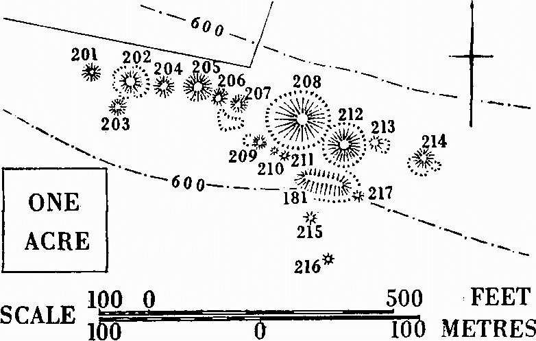
(L) Ailwood Down Group (SY 98 SE). Seventeen bowl barrows and a long barrow (181) on summit and S. shoulder of part of Purbeck Hills, here over 600 ft. above O.D. Ten form an irregular W.N.W.-E.S.E. line only 250 yds. long on the summit while the rest, including the long barrow, lie on slightly lower ground immediately to S. Only the two highest barrows (208 and 212) have continuous ditches. Some others have quarry pits, probably original. All are under turf. One, unidentified but adjacent, contained a cremation (W. A. Miles, Deverel Barrow (1826), 15; Hutchins I, 689).
(201) Bowl (?) (99388159). Diam. 30 ft., ht. 2 ft.
(202) Ditched bowl (99438158) 25 yds. E.S.E. of (201). Diam. 48 ft., ht. 7½ ft. Ditch broken by four causeways, two diametrically opposed on N. and S.
(203) Bowl (99428156) 15 yds. S.S.W. of (202). Diam. 25 ft., ht. 1 ft.
(204) Bowl (99468157) 22 yds. E.S.E. of (202). Diam. 43 ft., ht. 6 ft.
(205) Bowl (99498157) 23 yds. E. of (204). Diam. 55 ft., ht. 5 ft.
(206) Bowl (99518157) immediately S.E. of (205). Diam. 40 ft., ht. 3½ ft.
(207) Bowl (99538156) immediately S.E. of (206). Diam. 40 ft., ht. 3 ft. Probably original quarry pit on S.
(208) Ditched bowl (99568155) 43 yds. E.S.E. of (207). Diam. 90 ft., ht. 10 ft. Ditch, 20 ft. wide and up to 4 ft. deep, cuts that of (212).
(209) Bowl (99548154). The westernmost of three immediately S.W. of ditch of (208). Diam. 27 ft., ht. 2 ft.
(210) Bowl (99558154) 11 yds. S.E. of (209). Diam. 15 ft., ht. 9 ins.
(211) Bowl (99568154) immediately adjacent to (210) on S.E. Diam. 22 ft., ht. 1 ft.
(212) Ditched bowl (99598154) immediately S.E. of (208). Diam. 70 ft., ht. 8 ft., with ditch 10 ft. wide and 1 ft. deep cut on W. by that of (208).
(213) Bowl (99628154) immediately E. of (212), on outer lip of ditch. Diam. 35 ft., ht. 2 ft. Quarry pit on E.
Ailwood Down Group (L), Corfe Castle.
(214) Bowl (99658153) 35 yds. E.S.E. of (213). Diam. 40 ft., ht. 3 ft. Flat-topped, with quarry pits on S.W. and S.E.
(215) Bowl (99578150) 28 yds. S. of W. end of long barrow (181). Diam. 21 ft., ht. 1 ft. Cut by track.
(216) Bowl (99598147) 30 yds. S.S.E. of (215). Diam. 30 ft., ht. 1½ ft.
(217) Bowl (99618151) 47 yds. N.N.E. of (216) and impinging on line of long barrow ditch on S.E. Diam. 27 ft., ht. 1 ft.
(218) Bowl (?) (SY 98 SE; 95718378), possibly ditched. Diam. 45 ft., ht. 4½ ft. Cut on W. by road.
(219) Bowl (SY 98 SE; 98638355). On almost level site on Brenscombe Heath. Diam. 30 ft., ht. 3 ft. Hollowed on top.
Dorchester
Three barrows still exist and the position of a fourth is known; possibly six others have been destroyed. One probably lay at present junction of Alington St. and Princes St. beneath the Masonic Hall where a contracted inhumation with a B1 beaker was found in a cist; a ditch was also noted (Dorset Procs. XXIX (1908), 141, no. 111; MS. note with Moule's 25 in. map in D.C.M.; Abercromby I, 87, fig. 30). Two barrows, 'bell-shaped' and only 2 ft. apart, were recorded under the Roman town bank at the E. end of South Walks when levelled in 1864, one containing a possibly primary inurned cremation and several secondary inhumations (Dorset Procs. XVI (1895), 50–1; Cunnington, nos. 1 and 2). Two barrows, of which no trace remains, may also have existed around 69788990 (Taylor's Map of Dorset (1765); O.S. 1 in. (1811), 6 in. XL SE (1930)). Two small bronze daggers, presumably from a barrow, probably near Fordington, were found with at least six blunt bone implements perforated at one end and up to 3 ins. long (Wessex interment no. 9; Arch. J. v (1848), 322). For bucket urns from Dorchester and area see Dorset Procs. XXIX (1908), 138; Ant. J. XIII (1933), 445. For Conquer Barrow, see under Enclosures, West Stafford (24), p. 504.
(168) Bowl (SY 68 NE; 69708895) on crest of Conygar Hill on Bagshot Sands 280 ft. above O.D. and on parish boundary with Winterborne Herringston. Diam. 75 ft., ht. 11½ ft. Excavated by Cunnington, who found an inhumation lying N.-S. about 4 ft. above the original ground surface, with a nearby cremation.
(169) Bowl (SY 68 NE; 69798893) 105 yds. E. of (168) in similar situation. Diam. 75 ft., ht. 14 ft. Excavated by Cunnington. A primary contracted inhumation with a food-vessel at feet and six barbed-and-tanged flint arrowheads of 'Breton' type (fn. 1) at knees (Wessex interment no. 22) lay by a cremation. Above, a block of Portland stone, at depth of 9 ft., measured 7 ft. by 4 ft. by 1½ ft. and weighed nearly 3 tons. Of three secondary cremations, two lay close together 5 ft. from surface and one was in bucket urn 1½ ft. from surface. Food-vessel and arrow-heads in D.C.M. (Abercromby I, 95 and fig. 8; Ant. J. vii (1927), 459, and XIII (1933), 445.)
(170) Bowl (?) (SY 69 SE; 68179110; Fig. p. 488) inside Poundbury (Hill-forts, Dorchester (172)) near S. rampart. Diam. 85 ft., ht. 5 ft. Ploughed.
(171) Lawrence Barrow, bowl (SY 69 SE; 68499059). On shoulder of hill 300 ft. above O.D., formerly surrounded by open fields. A borough boundary stone stood on it. Destroyed 1885. Cunnington gives diam. as 35 ft. and ht. as 11 ft. At a depth of 8 ft. was an apparently secondary cremation with grooved copper dagger 8¾ ins. long and a small flat copper knife-dagger 3½ ins. long (Wessex interment no. 10). A typologically early collared urn had previously been found. Finds in D.C.M. (Butler & Smith, 58, no. 16; Archaeometry 4 (1961), 46–7, nos. 21, 36; P.P.S. XXVII (1961), 294, no. 22.)
Holme, East
Two barrows (SY 98 SW), on Holme Mount, lie inside embanked circle 200 ft. in diam. (tree-clump enclosure ?) within 200 ft. ring contour.
(6) Bowl (90698438). Diam. 45 ft., ht. 4½ ft. Brackencovered.
(7) Bowl (90688442) 45 yds. N.N.W. of (6). Diam. 40 ft., ht. 5 ft.
(8) Mound, possible barrow (SY 98 SW; 90508461) on summit of small knoll and within tree-clump enclosure. Diam. about 90 ft., ht. 10 ft. At least partly artificial.
Three barrows (SY 98 NW) lie above 50 ft. contour just S. of local crest of gravel spur running N. from Battle Plain (see Fig. p. 482). All were dug into by Austen in 1860 (Purbeck Papers I, 233–8). To N.W. and S. surrounding (9) and (10) is a large group of small mounds, one apparently impinging on (9) (see Mounds, E. Holme (12)).
(9) Bowl (90648528). Diam. 27 ft., ht. 2½ ft. An inverted urn, probably primary, lay in a cist cut into the sandy subsoil and covered with a sandstone slab. A secondary urn lay 'unprotected' 1½ ft. to the S. and 1 ft. from the surface. Mound (12c) overlaps (9) on W.
(10) Ditched bowl (90678529) 40 yds. N.E. of (9). Diam. 36 ft., ht. 4 ft. Probable cremation.
(11) Bowl (90698528) 20 yds. E.S.E. of (10). Diam. 36 ft., ht. 4½ ft. Nothing found.
Knighton, West
(21) Bowl (?) (SY 78 NW; 73528642; Fig. p. 139) on end of small, steep spur just over 200 ft. above O.D. and 230 yds. W.S.W. of Fryer Mayne House, W. Knighton (2). Diam. about 40 ft., ht. about 1½ ft. Overgrown.
(22) Bowl (?) (SY 78 NW; 73788924). Virtually destroyed 1890, when diam. 70 ft. Contained probable primary cremation in bucket urn beneath cairn. (Ant. J. XIII (1933), 445.)
(23) Bowl (?) (SY 78 NW; 74938842) in Knighton Heath Wood at head of gully just over 200 ft. above O.D. Diam. 19 ft., ht. 3 ft. Tree-covered.
(24) Huck Barrow, ditched bowl (SY 78 NW; 74958842) on almost level site about 20 yds. E. of (23). Diam. 52 ft., ht. 8 ft., with ditch about 10 ft. wide. Damaged and tree-covered.
Lulworth, East
Of eleven barrows, two (29–30) are on Upper Chalk, the rest on Reading Beds and mostly in heathland. 'Black Barrow' is natural. Sixteen or seventeen barrow excavations have been carried out: eight or nine in 1790 by Milner, seven in the 1820s by Pennie, and one in 1865 by Kendall. Two (29–30) of Milner's excavations were into barrows previously opened and some at least of Pennie's excavations were into barrows opened by Milner. Almost certainly these three diggers opened all the barrows below. One, fairly certainly (32), contained a bucket-urn cremation, probably primary, in a cist lined and covered in stone. Four or five of Milner's excavations, probably among (31–9), produced evidence 'nearly the same' as this. Some of the urns in these barrows were upright, others inverted. An unlocated barrow contained five inhumations, each with an urn (Warne, C.T.D., tovp, no. 12). Probably Pennie opened the two pairs called Water Barrows and Ferny Barrows ((36–7, 38–9): shown on J. Sparrow's Estate Map of E. Lulworth (1770), in D.C.R.O.), each barrow containing a probably primary inurned cremation within a cairn, apparently in at least three cases a substantial structure of large stones. Nothing in these accounts, poor even for Dorset, suggests that any of the barrows opened is of Early Bronze Age date. The use of stone in or under twelve or thirteen barrows in a small area, even allowing for duplicated records, is particularly striking. (Gentleman's Magazine (1790), 897–901; Austen, Purbeck Papers I, 35; Hutchins I, 381–4.) All the barrows are on O.S. 6 in. map SY 88 SE.
(29) Bowl (85668048). On tongue of land projecting W. below Rings Hill at about 150 ft. above O.D. Diam. about 21 ft., ht. 2 ft. Much damaged.
(30) Bowl (85688049). In similar situation 26 yds. N.E. of (29). Diam. about 60 ft., ht. 6 ft. Much damaged.
Bowls, three, spread and furze-covered, lie approximately in line on a gravel ridge over 200 ft. above O.D.
(31) (86308149). Diam. 65 ft., ht. 5½ ft.
(32) (86378147) 75 yds. E.S.E. of (31). Diam. 60 ft., ht. 4½ ft.
(33) (86418142) 60 yds. S.E. of (32). Diam. about 70 ft., ht. 2 ft.
(34) Bowl (86658129) on summit of Boat Knowl ('Boyt Knowl', 1770). Diam. about 45 ft., ht. about 5 ft. Much disturbed.
(35) Bowl (?) (86448195). On local eminence some 240 ft. above O.D. Diam. about 54 ft., ht. 2 ft. Centre disturbed.
The Water Barrows (1770), two, lie on almost level site about 220 ft. above O.D.
(36) Bowl (86538176). Very irregular; ht. 3½ ft.
(37) Bell (?) (86558180) 53 yds. N.N.E. of (36). Diam., including apparent berm on S.E., about 88 ft., ht. 9½ ft., with ditch 12 ft. wide, and 2½ ft. deep on all sides but N. where cut by road. Much disturbed, especially in centre.
The Ferny Barrows (1770), two, on summit of slight rise.
(38) Bowl (86648165) 180 yds. S.E. of (36). Diam. 48 ft., ht. 5 ft. Disturbed near centre.
(39) Bowl (86668161) 40 yds. S.E. of (38). Diam. 75 ft., ht. 6 ft. Damaged on N. and disturbed in centre.
Lulworth, West
There are no concentrations among the eighteen barrows in the parish, not even on Hambury Tout (three (39–41), two of them probably excavated 1790) or Bindon Hill (four possible barrows (42–5)).
(35) Mound, possible triple bowl (SY 78 SE; 79958076), partly overlaid on the W. by parish boundary with Chaldon Herring, prominently sited on crest of ridge and aligned at about 8°. Disturbed and very irregular in shape. Total length 114 ft., maximum width 36 ft.; N. crest is flat-topped, 12 ft. across and 4 ft. high, and covered with flints; S. crest is also flat-topped, 4½ ft. across and about 4½ ft. high; the middle crest is very slight and rounded. Shallow scoop at foot of S. mound but no sign of continuous ditch. Lynchets of Ancient Field Group (15) surround it (Fig. opp. p. 628).
(36) Bowl (SY 88 SW; 80078112) immediately E. of parish boundary with Chaldon Herring on slight S.E. slope. Diam. about 50 ft., ht. 5 ft. Partly ploughed.
(37) Bowl (?) (SY 88 SW; 80508128) near summit of ridge. Ploughed, only slight mound remains. Excavation in 1916 produced a primary (?) cremation in upright bucket-shaped urn in hole beneath flat stone about 5 ft. or 6 ft. W. of assumed centre (Dorset Procs. LXXXI (1959), 92–3).
(38) Bowl (?) (SY 88 SW; 80638134) 150 yds. E.N.E. of (37). Ploughed almost flat.
(39) Ditched bowl (SY 88 SW; 81188043) on spine of ridge sloping to W.N.W. Diam. 46 ft., ht. 4 ft., with ditch about 9 ft. wide. Top of mound markedly flattened but not obviously opened.
(40) Bell (SY 88 SW; 81588030) on rounded summit of Hambury Tout 454 ft. above O.D. Diam. 78 ft., ht. 9½ ft., with traces of berm and ditch. Path over top. Probably opened by Milner who found a large heap of ashes under a central cairn, above which was a contracted inhumation with an urn on its chest (Gentleman's Magazine (1790), 898; Hutchins I, 383).
(41) Ditched bowl (SY 88 SW; 81638030) on E. slope 65 yds. E. of (40). Diam. about 47 ft., ht. 3 ft. Much disturbed. Probably opened by Milner who found bones and urns (Gentleman's Magazine (1790), 899; Hutchins I, 383).
(42) Mound, possible barrow (SY 88 SW; 82968023), on Bindon Hill. Diam. 14 ft., ht. 1 ft. Abuts on W. side of cross-bank (c) (see Hill-forts, W. Lulworth (53), Fig. opp. p. 492).
(43) Mound, possible barrow (SY 88 SW; 83548031) about 14 yds. S. of quarry ditch of Early Iron Age rampart (see Fig. opp. p. 492). Diam. 30 ft., ht. 3½ ft.
(44) Mound, possible barrow (SY 88 SW; 84078026) on spine of Bindon Hill. Diam. 37 ft., ht. 3 ft. Top opened.
(45) Bowl (?) (SY 88 SW; 84098026) 23 yds. E. of (44). Diam. 35 ft., ht. 3½ ft. Top opened. Immediately E. is circular depression, 21 ft. in diam. and 1½ ft. deep.
(46) Barrow (?) (SY 88 SW; 82588168). Destroyed before 1939 by reservoir.
(47) Bowl (?) (SY 88 SW; 83188203) on almost level ground above 400 ft. Diam. about 36 ft., ht. 1 ft.
(48) Bowl (?) (SY 88 SW; 83288246) on almost level site near summit of ridge. Diam. about 30 ft., ht. 1 ft. Ploughed.
(49) Bowl (?) (SY 88 SW; 83318299) on same ridge as (48). Diam. about 45 ft., ht. 1½ ft. Ploughed.
(50) Bowl (?) (SY 88 SW; 83338307) on same ridge as (49), 90 yds. N.N.E. Diam. about 40 ft., ht. 1½ ft. Partly in hedgerow on E. Ploughed.
(51) Bowl (SY 88 SW; 83928294) in Burngate Wood on almost flat ground. Diam. about 18 ft., ht. 1 ft.
(52) Bowl (SY 88 SW; 83978299) on slight N.E. slope 95 yds. N.E. of (51). Diam. about 41 ft., ht. 2½ ft. Tree-covered.
Lytchett Matravers
(37) Henbury Barrow, bowl (SY 99 NW; 94899821) in Lower Sandy Coppice above 100 ft. contour on flat-topped spur. Diam. 47 ft., ht. 7 ft. Overgrown.
Morden
There are four barrows. A beacon mound (see Mounds, Morden (56)) may incorporate another.
(52) Ditched bowl (?) (SY 99 SW; 90369338) on almost level ground below 100 ft. Diam. 45 ft., ht. 5 ft. Disturbed on top and tree-covered.
(53) Cold Barrow, bowl (?) (SY 99 NW; 90479504), on highest point at N. end of prominent knoll defined by 200 ft. ring contour. Diam. about 21 ft., ht. about 2 ft., with flat top 9 ft. across. Tree-covered.
(54) Bowl (?) (SY 89 NE; 89869634) on almost level ground between 100 ft. and 150 ft. above O.D. Diam. about 90 ft., ht. about 2 ft. Under pasture, though probably ploughed.
(55) White Barrow (Taylor's Estate Map, 1773), bowl (?) (SY 99 NW; 91029665) on fairly level arable about 140 ft. above O.D. Only broad irregular rise about 2½ ft. high remains, suggesting former large mound.
Moreton
All three barrows, including a bell, are on Old Knowle, a large, prominent, natural knoll, above 100 ft. contour towards S. edge of Moreton Heath (SY 78 NE). They have been damaged by tree-felling. Another (LVG 3) has been claimed in an area now destroyed by quarrying.
(28) Bell (79888778). Diam. about 90 ft., ht. 11 ft., with berm about 7 ft. wide. Large tree-clump enclosure lies within and obscures original, probably large, ditch. Top hollowed.
(29) Ditched bowl (79938779) 55 yds. E. of (28). Diam. 41 ft., ht. 6 ft., with ditch 8 ft. wide.
(30) Ditched bowl (?) (79948777) 35 yds. S. of (29). Diam. 13 ft., ht. 2 ft.
Osmington
Although the N. end of the parish runs up to the Ridgeway, only eight barrows occur there including five in the East Hill Group ((R.14), Weymouth). Warne excavated two on the Ridgeway (C.T.D., mopr, nos. 5 and 6). No. 5, possibly either (35) or (36), contained a primary cremation in an urn in a chalk-cut cist beneath a flat stone; and two secondary contracted inhumations, one 4 ft. from the top in a flint cairn, the other immediately below the surface with vertical flat stones before and behind the head. No. 6 in the N.E. of the parish contained a bucket urn (no cremation is mentioned) in a cist surrounded by a circle of stones 10 ft. in diam., and a secondary urn was 4 ft. from the top. Coggins Barrow on the cliff edge is natural.
(30–4) See East Hill Group (R.14), Weymouth, p. 457.
(35) Bowl (SY 78 SW; 72388421) on crest of ridge. Diam. about 45 ft., ht. 1½ ft.
(36) Bowl (SY 78 SW; 72438421) 60 yds. E. of (35). Diam. uncertain, ht. 1 ft. Ploughed.
(37) Sandy Barrow, bowl (?) (SY 78 SW; 73028259), on spine of small knoll 367 ft. above O.D. Slight irregular flinty mound, disturbed in centre.
(M) Group (SY 78 SW, SE). Four bowls at wide intervals in W.-E. line along spine of ridge above 400 ft. contour. 'Celtic' field lynchets of Ancient Field Group (12) lie 11 yds. to 14 yds. N. of (39–41).
(38) Bowl (74698259). Much damaged by gun emplacement in centre.
(39) Bowl (74928260) 270 yds. E. of (38). Diam. 51 ft., ht. 5 ft., with many flints on surface. Ploughed.
(40) Bowl (75108258) 180 yds. E. of (39). Diam. 51 ft., ht. 4 ft. Ploughed.
(41) Ditched bowl (?) (75208257) 90 yds. E. of (40). Diam. 54 ft., ht. 2½ ft.
Owermoigne
There are twelve barrows. Two, unidentified, 'one on the downs and one on the heath', were opened in the 1890s. Both contained at least one inurned cremation, and from one came two urns, now in D.C.M. (Dorset Procs. XVII (1896), xxv–xxvi; XXIX (1908), 136–7; xxx (1909), xlviii.)
(22) Bowl (?) (SY 78 SE; 77168142) on ridge top in S.E. of parish. Ploughed almost flat.
(23) Bowl (?) (SY 78 SE; 77168152) 98 yds. N. of (22). Only slight mound remains.
(24) Bowl (SY 78 SE; 75608362) on Moigns Down. Diam. 35 ft., ht. 4 ft. Top dug into. In pasture.
(25) Bowl (SY 78 SE; 75498399) on S. edge of spur which projects N.W. from Moigns Down. Diam. 50 ft., ht. 3 ft. In pasture, but probably ploughed. Among 'Celtic' fields of Ancient Field Group (11).
(26) Bowl (?) (SY 78 SE; 76038375) on slope almost at top of S. side of Moigns Down ridge. Oval, about 48 ft. by 54 ft., possibly due to ploughing, and 1½ ft. high. In pasture.
(27) Ditched bowl (?) (SY 78 SE; 76078384) on slope to N. Diam. 53 ft., ht. 6 ft.
(28) Bowl (SY 78 SE; 76538400) on spine of spur running N.E. Diam. 44 ft., ht. 5½ ft. Overgrown.
(29) Bowl (SY 78 NE; 77998595) on small knoll on Galton Heath. Diam. 35 ft., ht. 3 ft.
(30) Bowl (SY 78 NE; 77878759). Diam. 51 ft., ht. 5 ft. Treecovered.
(31) Tinkers' Barrow, ditched bowl (SY 78 NE; 77918785). In plantation on top of S. slope. Diam. 44 ft., ht. 4 ft., with ditch 9 ft. wide. Large excavation on top.
(32) Barrow (?) (SY 78 NE; 78158783) destroyed by quarrying.
(33) Tadnoll Barrow, bowl (?) (SY 78 NE; 79148747). On slight knoll in heathland and cut by parish boundary with Moreton, E. of which road has destroyed two-thirds of site. Diam. about 56 ft., ht. about 5 ft.; around, and 3 ft. from it on W., is a probable tree-clump enclosure, about 75 ft. in diam.
Poole
Forty-one widely-scattered barrows lie on the heath-lands N. of the town, many on ridges or spurs above the 200 ft. contour; seven have now been destroyed. Eighteen occur in three groups: on Canford Heath (four); near Rose Lawn Coppice (eight); and on Barrow Hill (six). The first and last of these contain lines of four barrows and the Barrow Hill Group includes four bells, at least two of which were amongst three barrows opened in the mid 19th century. Although remains of a burial occurred in only one of three modern excavations, all revealed evidence of timber structures with openings to the S.E.; two of these barrows (363–4) had narrow berms, and the other (365) was without a ditch.
(361) Fern Barrow, bowl (?) (SZ 09 SE; 06999259), on level site overlooking Bourne valley. Original diam. about 42 ft., ht. about 4½ ft., but much damaged.
(362) Mound, barrow (?) (SZ 09 SE; 05429431), on Alderney Heath, now destroyed by gravel digging.
(363) Bell (SZ 09 SE; 05689432), built over after complete excavation by H. J. Case in 1949. Overall diam. 43 ft. A central oval sod mound 14 ft. by 12 ft. and 1½ ft. high was edged by revetment of sandy material 22 ft. by 17 ft. and covered with gravel, giving the whole mound diam. of 26 ft. and ht. of about 2½ ft. Berm 3 ft. wide within ditch 5 ft. wide and about 2 ft. deep, interrupted on S.E. by causeway at least 3½ ft. wide. Previous disturbance had destroyed any evidence of burial.
Two small pits containing charcoal were excavated, one 3½ ft. long immediately E. of centre and the other 7½ ft. W. of centre. Beneath mound and on berm were thirty-nine stake-holes, all except four between 1 in. and 4 ins. deep in the Plateau Gravel subsoil. Twelve formed approximate circle 19 ft. in diam., outside, though not concentric with, edge of revetment around central sod mound. The only small finds were 274 struck flints, mostly from top of mound, and many fire-pitted pebbles. Probably Early or Middle Bronze Age, and possibly later than (364). (P.P.S. XVIII (1952), 148–59; and XIX (1953), 131–3.)
(364) Bell (SZ 09 SE; 05699432) immediately adjacent to (363) on E. and now built over after complete excavation by H. J. Case in 1949. Overall diam. 40 ft. A central mound of sods with vegetation uppermost, 10 ft. in diam. and about 1 ft. high, was covered with gravel to give total diam. of 22 ft. and ht. of 1½ ft. Berm 3 ft. to 5 ft. wide lay within almost perfectly circular ditch 5 ft. wide and 2 ft. to 2½ ft. deep interrupted on S.E. by causeway at least 3½ ft. wide. Beneath sod mound remains of a disturbed central grave 5 ft. long and 6 ins. deep held traces of a presumably primary cremation. Much charcoal, including lumps up to 1 ft. long, lay around the grave; a sample was of oak.
Thirty-two post-holes and twenty-four stake-holes were found. Sixteen post-holes were approximately equidistant on circumference of a circle 28 ft. in diam., around outer edge of berm: ten, associated with the causeway, suggested an entrance structure; and six lay outside the ditch, five of them S.E. of causeway, possibly marking-out posts. They varied between 3 ins. and 15 ins. in depth. Twelve stake-holes, 1 in. to 4 ins. deep, lay beneath sod mound; three, leaning towards the grave, suggested possible temporary structure over it. The others lay at or immediately beyond edge of sod mound, six on an arc from barrow centre. Seventy-nine struck flints, mostly from top of mound, and many fire-pitted pebbles, mostly from sod mound and buried surface, were found. Pollen analysis suggested that forest clearance was welladvanced when the barrow, probably in Early or Middle Bronze Age, was built on land perhaps previously cultivated. (P.P.S. XVIII (1952), 148–59; and XIX (1953), 131–3; Arch. J. CXIV (1957), 1–9; P. Ashbee, The Bronze Age Round Barrow in Britain (1960), 60–5.)
(365) Bowl (SZ 09 NW; 04229511) above 200 ft. contour on S. edge of Canford Heath plateau. Destroyed by gravel quarry after complete excavation by P. Ashbee in 1951. The mound, diam. about 30 ft., ht. 3 ft., was of soil and gravel, heaped on site possibly stripped of topsoil. Nineteen post and stake-holes lay about 2¾ ft. apart in a rough arc on the N.E. and E., all but two beneath the mound and all but one 4½ ins. to 5 ins. deep; three were slots about 6 ins. by 4 ins. On W. and S., arc continued as two sections of irregular and shallow trench, linked by three stake-holes and perhaps formed from similar holes by differential weathering. A flanked entrance lay on S.E. No burial occurred in central oval pit, 5 ft. by 4 ft. and a few ins. deep, with pile of gravel to E. presumably dug from it. Immediately S.W., though in body of mound, was about 4 ft. of carbonised hollowed oak tree-trunk. Only other finds were 140 flint flakes and cores over top of mound. (P.P.S. XIX (1953), 131–3; Dorset Procs. LXXVI (1954), 39–50; Ashbee, op. cit. in (364), 44, 56, 60–5.)
(366) Bowl (?) (SZ 09 NW; 02659534) in conspicuous position on Lodge Hill above 200 ft. contour and re-entrant valley to E. Diam. 50 ft., ht. 3½ ft. Slight hollow on top.
(367) Bowl (SZ 09 NW; 02759534) on opposite side of reentrant, 100 yds. E of (366). Diam. 22 ft., ht. 3 ft. Much damaged.
(368) Ditched bowl (?) (SZ 09 NW; 03039530) on S. edge of Canford Heath plateau above 200 ft. Diam. 36 ft., ht. 3½ ft. Hollowed on top and much damaged.
(N) Canford Heath Group (SZ 09 NW). Four bowls in slightly irregular W.S.W.-E.N.E. line near W. edge of plateau, above 200 ft. contour and steep W. slope. All much damaged.
(369) Bowl (02279545). Diam. 57 ft., ht. 5 ft.
(370) Ditched bowl (02299545) 20 yds. E.N.E. of (369). Diam. 39 ft., ht. 4½ ft., with ditch about 7 ft. wide.
(371) Bowl (02329545) 30 yds. E. of (370). Diam. 43 ft., ht. 5 ft.
(372) Ditched bowl (02339546) 15 yds. E.N.E. of (371). Diam. 33 ft., ht. 4½ ft., with ditch about 6 ft. wide.
(373) Bowl (SZ 09 NW; 02439559) on level site above 200 ft., 180 yds. N.E. of (372). Diam. 27 ft., ht. 3½ ft. Much damaged.
(374) Bell (?) (SZ 09 NW; 01889586) on S. edge of spur, above 200 ft., jutting S. from plateau. Diam. 30 ft., ht. 3 ft., with berm 7 ft. wide about 2 ft. above ground level, and ditch about 10 ft. wide.
(375) Bowl (?) (SZ 09 NW; 04389591) on Knighton Heath just below 200 ft. on slope to N. Diam. about 20 ft., ht. about 2 ft. Destroyed.
(376) Bowl (SZ 09 NW; 04699598) in similar position to (375). Diam. 33 ft., ht. 4 ft. Damaged.
(377) Ditched bowl (SZ 09 NW; 04369618) above small stream on slight ridge between 100 ft. and 150 ft. above O.D. Diam. 32 ft., ht. 3½ ft., with ditch 6 ft. wide. Slight hollow in centre; S. side destroyed by golf tee.
(378) Bowl (?) (SZ 09 NW; 03439614) on level site above slopes N. and W. to small valley. Diam. 43 ft., ht. 5 ft., but now damaged and isolated in gravel pit. Hollowed on top.
(379) Bowl (?) (SZ 09 NW; 03459615) 15 yds. N.E. of (378). Diam. about 40 ft., ht. about 4½ ft. Destroyed.
(380) Ditched bowl (SZ 09 NW; 02589625) on level site within 200 ft. ring contour. Diam. 39 ft., ht. 4 ft. Damaged.
(381) Ditched bowl (SZ 09 NW; 02539641) in similar position to (380) 185 yds. to N.N.W. Diam. 28 ft., ht. 3 ft., with ditch 4 ft. wide.
(382) Bowl (?) (SZ 09 NW; 01469655) above 200 ft. contour on tip of spur. Diam. 36 ft., ht. 4 ft. Hollowed on top.
(383) Bowl (SZ 09 NW; 01899677) in Arrowsmith Coppice at end of low ridge above gentle N. slope. Diam. 54 ft., ht. 5 ft.
(384) Bowl (SZ 09 NW; 01889679) in similar position 25 yds. N.N.W. of (383). Diam. 30 ft., ht. 3 ft.
(385) Ditched bowl (SZ 09 NW; 02629690) on fairly level site above steep slopes to W. and N.W. Diam. 40 ft., ht. 5 ft., with ditch about 6 ft. wide. Damaged by gravel digging.
(386) Ditched bowl (?) (SZ 09 NW; 01999732) in Gravel Hill Plantation. Formed pair with (387). Destroyed by gravel digging.
(387) Bowl (SZ 09 NW; 02019732) on edge of ridge above S.E. slope 25 yds. E. of (386). Diam. 45 ft., ht. 5½ ft. Damaged by gravel digging.
(O) Rose Lawn Group (SZ 09 NW). Eight barrows, forming a compact group though with no obvious focus, on and towards N.E. end of broad ridge above 200 ft. contour. Most are on golf course.
(388) Ditched bowl (00579749). Diam. 48 ft., ht. 8 ft., with ditch 12 ft. wide and up to 1 ft. deep. Hollowed on top.
(389) Bowl (00759749) 200 yds. E. of (388). Diam. 21 ft., ht. 1½ ft.
(390) Bowl (00769744) 45 yds. S.S.E. of (389). Diam. 31 ft., ht. 3½ ft.
(391) Bowl (00779754) in Rose Lawn Coppice 115 yds. N. of (29). Diam. 45 ft., ht. 5 ft.
(392) Ditched bowl (?) (00799751) 30 yds. S.E. of (391) and similarly planted. Diam. 51 ft., ht. 7 ft.
(393) Bowl (00939742) 170 yds. S.E. of (392). Diam. 16 ft., ht. 1 ft. Damaged.
(394) Bowl (?) (00939743) 20 yds. N.E. of (393). Diam. about 21 ft., ht. 1½ ft. Damaged and tree-covered.
(395) Barrow (?) (01009743) 70 yds. E. of (394), converted into golf tee. Diam. probably about 60 ft., and ht. over 6 ft.
(P) Barrow Hill Group (SY 99 NE). Six barrows, including four bells, on flat-topped ridge above 200 ft. contour. (396–9) form a short S.W.-N.E. alignment. All but (399) have probably been excavated. Three barrows on 'Merley Heath' were excavated by Austen in 1847: two of (396–8) contained unaccompanied cremations beneath a layer of flints; and either (400) or (401) contained a primary cremation in an upright Middle or Late Bronze Age urn, and at least five intrusive inhumations in top of mound (Ant. J. XIII (1933), 444).
(396) Ditched bowl (99589745). Diam. 20 ft., ht. 2½ ft.
(397) Bell (99609746) 25 yds. N.E. of (396). Diam. 20 ft., ht. 3 ft., with berm about 6 ft. wide and ditch about 7 ft. wide.
(398) Bell (99669752) 75 yds. N.E. of (397). Diam. about 22 ft., ht. 3½ ft., with berm about 5 ft. wide and ditch about 7½ ft. wide.
(399) Bowl (?) (99699755) 56 yds. N.E. of (398). Diam. 19 ft., ht. 1 ft.
(400) Bell (99599767) 160 yds. N.W. of (399). Diam. about 50 ft., ht. 7½ ft., with traces of berm on S.E. and damaged, irregular ditch about 9 ft. wide.
(401) Bell (99569768) 30 yds. N.W. of (400). Diam. about 40 ft., ht. 7½ ft., with berm about 5 ft. wide and ditch 9 ft. wide and 1 ft. deep.
Portesham
Most of the twenty-two barrows in the parish are scattered in small clusters or singly on the Ridgeway and the lower hills to the S. The scattered Black Down Group (R.5) is on the highest point of the Ridgeway, and two pairs of barrows form part of the Bronkham Hill and Ridge Hill Groups (R.6 and R.7). On Friar Waddon Hill, S. of the Ridgeway, is a double bowl and a smaller linear group (Q).
(R.5) Black Down Group (SY 68 NW). Ten barrows, including one bell, on gravel-capped heath around Hardy Monument above 700 ft. Five are in Portesham (34–8), the others in Winterbourne Steepleton (16–19) and Little Bredy (Dorset I, no. 12).
Little Bredy:
(12) Bowl (60478784). Diam. 46 ft., ht. 5 ft.
Winterbourne Steepleton:
(16) Bowl (60578787) on N.E. slope 107 yds. E.N.E. of last. Diam. 35 ft., ht. 4½ ft. Disturbed.
(17) Bowl (61018787) 480 yds. E. of (16). Diam. 30 ft., ht. 4½ ft.
(18) Bowl (61018779) 70 yds. S. of (17). Diam. 30 ft., ht. 4 ft.
(19) Bowl (61148766) 205 yds. S.E. of (18). Diam. 42 ft., ht. 3 ft. Much damaged by digging, with probable spoil on N.W.
Portesham:
(34) Bowl (?) (61318760) immediately E. of Hardy Monument. Diam. 20 ft., ht. 1 ft.
(35) Bowl (61328761) immediately E. of (34) on edge of steep N.E. slope. Diam. 64 ft., ht. 5 ft. Excavated in centre.
(36) Bowl (61388757) below and 75 yds. S.E. of (35). Diam. 33 ft., ht. 4 ft.
(37) Bowl (61308755) 40 yds. S. of Monument. Diam. 28 ft., ht. 1½ ft.
(38) Bell (61288749) 110 yds. S. of Monument. Overall diam. 110 ft.: mound 80 ft. across and 7 ft. high, and partly removed on W. by gravel pit which revealed a turf core with gravel capping; berm 10 ft. wide and ditch about 8 ft. wide at the lip, 5 ft. deep and narrow at the bottom. Mound possibly examined from this side by Cunnington who in 1878 dug into a damaged barrow about 100 yds. 'north' of the Monument and exposed a pit 6 ft. deep and 5 ft. across with ashes, two whetstones and flint flakes under large stones, all lying beneath a 'very black part' (Cunnington MS. no. 52). Excavation in 1955 (P.P.S. XXIII (1957), 124–36) revealed four biconical and sub-biconical Middle Bronze Age urns, three with cremations, near the top of the mound.
(39–40) See E. end of Bronkham Hill Group (R.6), Winterborne St. Martin, p. 467.
(41–2) See Ridge Hill Group (R.7), Winterborne St. Martin, p. 467.
(43) Bowl (SY 68 NW; 64578646), the only barrow down the slope S. from the Ridgeway. Diam. 70 ft., ht. 8½ ft. Cunnington in 1885 found primary contracted inhumation in cist, and remains of a child inhumation, surrounded by large stones. Above was cremation in large urn with smaller vessel (in D.C.M.); 3 ft. higher, 6 ft. below the top of the mound, lay two extended inhumations, each with a vessel at its head (one in D.C.M.). Near top of the mound was child inhumation in a grave partly consisting of a Roman roof slab, associated with a Romano-British sherd. Part of a saddle quern was in the body of mound. (Dorset Procs. XVI (1895), 177 and XXXVII (1916), 45; Ant. J. XIII (1933), 446.)
(44) Bowl (?) (SY 58 NE; 59658688). Diam. about 67 ft., ht. 2½ ft. Much ploughed; probably associated with two adjacent stones immediately S. (see Stones, Portesham (59)). (Dorset Procs. XXIX (1908), lxxiv; O.S. Map of Neolithic Wessex, no. 144; P.C.T.E.W., 235.)
(45) Bowl (?) (SY 58 NE; 59758645) near summit of Broom Barrow hill. Only much disturbed cairn, 20 ft. in diam., remains.
(46) Mound, possible barrow (SY 68 NW; 60488670), on S. shoulder of Portesham Hill 100 yds. W.S.W. of Hell Stone (Long Barrow, Portesham (33)), in area with 'Celtic' fields and later quarrying. Diam. about 42 ft., ht. about 3 ft.
(47) Bowl (?) (SY 68 NW; 60658669) 70 yds. E.S.E. of Hell Stone (33). Low elongated mound remains. When excavated by Cunnington in 1894 it measured 48 ft. by 16 ft., was 6 ft. high and had apparently been cut back in making a wall. It covered an inurned cremation (Dorset Procs. XVI (1895), 176).
(48) Bowl (?) (SY 68 NW; 61688603) on crest of narrow ridge above 500 ft. Oval, 52 ft. by 21 ft., and 4 ft. high, apparently cut back by strip cultivation (see Portesham (32e), p. 246).
(49) Bowl (?) (SY 68 NW; 63418557) near E. end of Corton Hill, on spine. Diam. 46 ft., ht. 3 ft.
(50) Bowl (?) (SY 68 NW; 64028554) on crest of Friar Waddon Hill. Diam. 20 ft., ht. 1¼ ft.
(51) Double bowl (SY 68 NW; 64068550) 56 yds. S.E. of (50). Diams. of mounds 35 ft. and 32 ft., hts. 3½ ft. and 3 ft.; joined by slight bank. Top of S.E. mound flattened, probably by excavation.
(Q) Friar Waddon Hill Group (SY 68 NW). Four bowls along crest of E. end of hill, one above 400 ft., the others on E. slope.
(52) (64488546). Irregular in plan, 29 ft. by 23 ft., and 2½ ft. high.
(53) (64548545) 65 yds. E. of (52). Diam. 42 ft., ht. 5 ft. Excavated in centre.
(54) (64608540) 80 yds. E.S.E. of (53). Diam. 31 ft., ht. 3 ft.
(55) (64678542) 85 yds. E. of (54). Diam. 25 ft., ht. 2 ft.
Portland
No certain barrows remain but the site of an urnfield within a mound is known. A burial found with a fourhandled biconical jar of Armorican type suggests a possible but unlocated barrow on North Common below Verne Hill (Arch. J. XXV (1868), 50 (fig.); Archaeologia XLIII (1871), 339 and fig. 19; L'Anthropologie IV (1951), 432–5).
(96) Bowl(?) (SY 67 SE; 68747077). At Suckthumb or Suckton Quarry part of a 'slightly raised mound' surrounded by a ditch was destroyed by quarrying in 1905 when about 160 urns were dug up and nearly all immediately smashed. It was later reported that 'probably 100 to 200' urn burials had been found in the mound, but it is not clear whether this refers to the earlier destruction or to a new group of urns. Some survive in D.C.M. (Dorset Procs. XXVI (1905), xxxix; XXIX (1908), CXV; Abercromby II, 42, figs. 419, 419a.)
Poxwell
Warne excavated two unlocated barrows (C.T.D., mopr, nos. 7 and 8) on 'Pokeswell Down, adjoining the Ridgeway'; one of these may be (11), in the Northdown Barn Group (R.13). Otherwise only two certain barrows are known, emphasising the break in the distribution of barrows on the Ridgeway E. of East Hill Group (R.14). A barrow, possibly one of those excavated by Warne, is shown about 715848 on O.S. (1811).
(11) See Northdown Barn Group (R.13), Weymouth, p. 457.
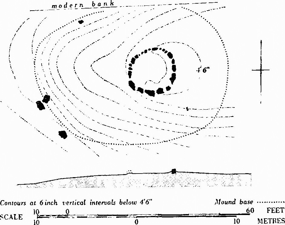
(12) Barrow (SY 78 SW; 74518357; Plate 211), situated on crest of E.-W. limestone ridge just under 400 ft. Turf-covered mound now oval, about 63 ft. E.-W. and 44 ft. N.-S., with almost flat top, offset to E.; about 2 ft. high. On E. side of top, at probable approximate centre of an original circular mound, is exposed a continuous ring of stones, 14 ft. in diam. (cf. Bincombe (24), Group (R.8), Weymouth, p. 456). The stones are a 'recrystallised variety of sarsen' (Arkell, 241). On S. some stand up to 2½ ft. high, while on N. they are virtually flush with the surface. The spaces between all are packed with small limestone rubble. The four stones peripheral to mound on the W. seem more likely to be from this circle than to belong to an outer peristalith. No ditch is visible (but cf. Hutchins I, 408; Warne, Ancient Dorset, 119–20). A later boundary bank runs along N. side. (Dorset Procs. VI (1884), 55–7; Reliquary, XI (1870–1), 154–7.)
(13) Mound, possible barrow (SY 78 SW; 74728395), 430 ft. above O.D. on almost level site just above S. slope. Height 2 ft. Ploughed.
(14) Bowl (?) (SY 78 SW; 74688416) above 400 ft. on N. slope. Now 35 ft. by 29 ft. due to ploughing at base, ht. 4½ ft.
Stafford, West
(18) Bowl (?) (SY 78 NW; 72428904). Near summit of slight ridge over 200 ft., above gentle N.W. slope. Ploughed almost flat.
(19) Sandy Barrow, bowl (SY 78 NW; 72788909). On level site above 200 ft. Diam. about 85 ft., ht. about 9 ft. Cut on W. by lane and densely overgrown.
(20) Bowl (SY 78 NW; 71518970). On Frome Hill above 200 ft. Diam. about 55 ft., ht. 6 ft. Irregular.
(21) Bowl (?) (SY 78 NW; 71478972) 47 yds. N.W. of (20). Ploughed almost flat.
(22) Conquer Barrow, barrow (?) SY 70798990, on bank of 'henge' monument, see Enclosures, West Stafford (24), p. 504.
(23) Barrow (?) (SY 78 NW; 70998995). Near centre of 'henge' monument (24). A 'mound or barrow at the centre' was claimed by R. J. C. Atkinson (Excavations at Dorchester, Oxon. (First Report) (1951), 104–5). R.A.F. V.A.P. CPE/UK 1934: 5082–3, suggest former mound here but no clear traces remain on the ground.
Steeple
All but one (19) of the seven known barrows are on Grange Heath. One on the heath about ½ mile from Creech Grange—possibly (21)—was said to have been removed in 1854; from it came three secondary inurned cremations. Between the urns was part of an inhumation covered by Purbeck stones, the whole deposit being on a rough flint paving (Purbeck Papers I, 238; Hutchins I, 613).
(19) Bowl (SY 98 SW; 90158257) on summit of slight rise defined by 200 ft. ring contour just S. of Pomphrey's Plantation. Diam. 43 ft., ht. 4 ft., surrounded by tree-clump enclosure and tree-covered.
(20) Drinking Barrow, bowl (SY 98 SW; 90698313) at N. corner of Great Plantation above 200 ft. on small knoll. Oval, 45 ft., E.-W. and about 54 ft. N.-S., ht. 4 ft. No surrounding ditch, that about 6 ft. from base on W. being part of abandoned system of copse banks and ditches, and depression along E. being disused track.
(21) Ditched barrow (?) (SY 98 SW; 90728309) 45 yds. S.E. of (20) on slightly lower ground. D-shaped in plan and flat-topped. Diam. about 25 ft., ht. 1 ft. Ditch 6 ft. to 10 ft. wide and 2 ft. deep. Counterscarp bank, spread over about 10 ft. but only 6 ins. high, best-preserved on N. and E. Disturbed by trees.
(22) Ditched bowl (SY 98 SW; 90768326) on crest of slight E.-W. ridge about 170 ft. above O.D. and 170 yds. N.E. of (20). Diam. 40 ft., ht. 3 ft. Cut by track.
(23) Ditched bowl (SY 98 SW; 90808326) in similar position 46 yds. E. of (22). Diam. 25 ft., ht. 1 ft., with ditch 6 ft. wide and up to 1 ft. deep.
(24) Ditched bowl (SY 98 SW; 91128340) on slight S.E. slope, steepening some 20 yds. to S. Diam. 30 ft., ht. 3 ft., with ditch about 4 ft. wide. Tree-covered.
(25) Bowl (?) (SY 98 SW; 90668374) about 170 ft. above O.D. towards W. end of slight ridge. Diam. 55 ft., ht. 5 ft., surrounded by tree-clump enclosure. Overgrown.
Stoke, East
All twenty-nine barrows lie on heathland to N. and S. of the Frome, eleven in two groups. That on West Holme Heath is a good example of a linear group related to only a slight ridge. Many have been damaged by military activity. A completely excavated example on Chick's Hill (22) produced a primary cremation in a globular urn. In another small barrow at Highwood, now unidentifiable but possibly one of (21–5), were three inverted urns with cremations at a depth of 2 ft. (Hutchins I, 413).
(21) Ditched bowl (SY 88 NE; 86768559) near end of ridge. Diam. 64 ft., ht. 5 ft. with ditch 9 ft. wide. Excavation in top.
(22) Ditched bowl (SY 88 NE; 86878588) on Chick's Hill, a spur S. of the Frome, just over 50 ft. above O.D. Diam. about 28 ft., ht. 3 ft., before partial destruction and excavation in 1955–6. Primary cremation in inverted globular urn lay just above old surface in centre on large flints and immediately above small infilled pit with signs of burning. Some 6 ft. to N.E. was a similar pit containing pine and oak charcoal and burnt flints. The mound had been heaped up in stages with material from slightly irregular flat-bottomed ditch about 5 ft. wide and 3 ft. deep. Some cultivation had probably taken place in the area before the barrow was built. (Dorset Procs. LXXX (1958), 146–59.)
Three barrows, including a bell, lie close together on a low rise on Highwood Heath (SY 88 NE).
(23) Bowl (?) (86988543). Diam. 20 ft., ht. 2 ft. Trench across centre.
(24) Ditched bowl (?) (87018543) 33 yds. E. of (23). Diam. 24 ft., ht. 1 ft. Damaged.
(25) Bell (87038539) on summit of rise above 100 ft. contour 46 yds. S.S.E. of (24). Diam. of mound and sloping berm 93 ft., ht. 9 ft., with ditch 10 ft. wide and 2½ ft. deep.
(S) West Holme Heath Group (SY 88 SE). Five, possibly six, barrows lie in an almost straight E.-W. line on a slight ridge in an area devastated by tanks.
(26) Mound, possible barrow (88238460). Diam. about 60 ft., ht. 2 ft. Cut by road on W.
(27) Bowl (88268460) 30 yds. E. of (26). Diam. 54 ft., ht. 4 ft.
(28) Bowl (88298460) 30 yds. E. of (27). Diam. 58 ft., ht. 3½ ft.
(29) Bowl (88328460) 33 yds. E. of (28). Diam. 50 ft., ht. 4 ft. Disturbed in centre.
(30) Bowl (88348460) 23 yds. E.S.E. of (29). Diam. 44 ft., ht. 4½ ft. Disturbed in centre.
(31) Bowl (88378459) 30 yds. E.S.E. of (30). Diam. 56 ft., ht. 4½ ft.
(32) Bowl (SY 88 NE; 85838739) on S. end of ridge. Diam. 46 ft., ht. 4 ft.
(33) Bowl (?) (SY 88 NE; 88718722) in woodland on South Heath. Diam. about 30 ft., ht. about 4 ft.
(34) Bowl (?) (SY 88 NE; 88798723) 92 yds. E. of (33). Diam. about 30 ft., ht. 3 ft.
Three barrows, including a probable bell, form a triangular cluster on top of a ridge at S. edge of South Heath (SY 88 NE).
(35) Bell (?) (89388708). Diam. of mound and slight berm about 36 ft., ht. 5 ft., with ditch about 7 ft. wide and 1 ft. deep.
(36) Ditched bowl (89408707) 20 yds. S.E. of (35). Diam. 28 ft., ht. 4½ ft.
(37) Ditched bowl (89418710) 20 yds. N.N.E. of (36). Diam. 40 ft., ht. 5 ft.
(38) Ditched bowl (SY 88 NE; 85998811). Diam. 66 ft., ht. 8 ft. Tank track through centre.
(39) Ditched bowl (SY 88 NE; 85848833) on level site. Diam. 70 ft., ht. 6 ft., with ditch 8 ft. wide.
(40) Ditched bowl (SY 88 NE; 85958873). Diam. 45 ft., ht. 4 ft. Damaged.
(41) Bowl (?) (SY 88 NE; 87238825) on almost level site near top of steep scarp to S. Diam. about 50 ft., ht. 4 ft., but largely destroyed.
(42) Barrow (?) (SY 88 NE; 87308816) 130 yds. S.E. of (41), completely destroyed. Possibly only a tree-clump enclosure.
(43) Barrow (?) (SY 88 NE; 87468828) 230 yds. N.E. of (42). Destroyed by gravel quarry.
(44) Ditched bowl (SY 88 NE; 87648857) on slight N. slope below 100 ft. Diam. 47 ft., ht. 5 ft.
(T) Farm Heath Group (SY 88 NE). Five barrows on slope dropping N. towards River Piddle.
(45) Ditched bowl (88848789) on summit of knoll with steep fall to N. Diam. 46 ft., ht. 8 ft. Much damaged, top excavated.
(46) Bowl (89028783) on flat top of small plateau 220 yds. E.S.E. of (45). Diam. 63 ft., ht. 6 ft. Trench cuts into centre.
(47) Mound, possible barrow (89028794), 133 yds. N. of (46) on top of small knoll. Very disturbed.
(48) Barrow (?) (89158791) 146 yds. E.S.E. of (47). Nothing visible on top of knoll.
(49) Bowl (89288774) above 100 ft. contour 226 yds. S.E. of (48). Diam. 36 ft., ht. 2½ ft. Much disturbed.
Studland
The fourteen barrows include two, probably four, bells. Eight, including the bells, fall within two groups on the N.-facing escarpment overlooking Poole Harbour. A natural knoll, protected by the Agglestone and sometimes thought to be a barrow (Arkell, 224), is excluded, as are three unlocated mounds claimed as possible barrows N. of Dean Hill (Dorset Procs. LXXVI (1954), 79). A barrow possibly existed at about 035817 in or beside Cracker Barrow Furlong below Ballard Down (Tithe Map, 1840). A primary crouched inhumation was found in (29).
(29) Ulwell Barrow, ditched bowl (SZ 08 SW; 02238132). On nearly level site at lower, W., end of Ballard Down, above steep slopes to S., W. and N. and below gentle rise to E. Diam. 74 ft., ht. 6 ft., with ditch 12 ft. wide. Excavation hollow in top, and cut by hedge-bank from N.; on S., where crossed by parish boundary with Swanage, lies a collapsed obelisk dated 1892 and erected to commemorate 'the introduction of pure water from the chalk formation into Swanage'. In 1857 Austen found a primary contracted inhumation, the skull surrounded by flat stones, in chalk-cut grave 8 ft. by 5 ft. with handled cup of fine red ware; antler fragments occurred in grave filling. In mound near centre were a disarticulated inhumation with urn fragments and, slightly higher, a cremation under a flat stone with more urn fragments. In top of mound were Iron Age and/or Romano-British debris and many flint chippings. (Purbeck Papers I, 157–60; Ant. J. XIII (1933), 447.)
(30) Bowl (?) (SZ 08 SW; 04208132) just S. of spine of ridge. Diam. 20 ft., ht. 1 ft. Hollowed on top.
(U) Godlingston Heath Group (SZ 08 SW). Four barrows, including two, probably three, bells, all relatively undamaged.
(31) Bell (00708193). Diam. 58 ft., ht. 4 ft., with berm up to 8 ft. wide and ditch 11 ft. wide and 1½ ft. deep.
(32) Bell (00728197) adjacent to (31) on N.N.E. Diam. 56 ft., ht. 3 ft., with berm about 12 ft. wide and ditch 12 ft. wide and 1½ ft. deep. Excavation on top.
(33) Bell (?) (00688200) 66 yds. N.W. of (32) and unusually irregular in shape, probably because on small natural knoll. Diam. 52 ft., ht. 4½ ft., with irregular berm 25 ft. wide on N., 15 ft. wide on S. and almost absent on E. Ditch 14 ft. wide, 6 ins. to 2 ft. deep on W. and N. and absent on S. where its line interrupted by (34).
(34) Bowl (?) (00678199) immediately S.S.W. of (33). Diam. 30 ft., ht. 2 ft.
(V) Thorny Barrow Group (SZ 08 SW). Four barrows, including a probable bell, in a straight line near S. edge of Godlingston Heath above N. slope. All damaged.
(35) Thorny Barrow, bowl (?) (01438210), on edge of broad ridge but almost unrecognisable owing to encroachment of large sand pit. Diam. about 65 ft., ht. about 8 ft.
(36) Bowl (01648212) 225 yds. E. of (35). Diam. 30 ft., ht. 1½ ft.
(37) Bowl (01658212) immediately E. of (36). Diam. 37 ft., ht. 2 ft.
(38) Fishing Barrow, bell (?) (01818211), 175 yds. E. of (37). Diam. including berm 99 ft., ht. 9 ft., with ditch 12 ft. wide and 1½ ft. deep. Berm largely obscured by slip from mound, which is flattened on top by golf tee.
(39) Mound, possible barrow (SZ 08 SW; 01798268). On Godlingston Heath above large sand pit to N.W. and steep slope to N.E. Diam. 37 ft., ht. 3 ft., but similar to natural rises in adjacent heath.
(40) Bowl (?) (SZ 08 SW; 03238306) on natural knoll and merging with it. Diam. about 60 ft., ht. about 2 ft. Hollowed on top.
(41) Bowl (?) (SZ 08 SW; 03308299) in garden of Studland Bay House 120 yds. S.E. of (40). Diam. 46 ft., ht. 6 ft.; E. half removed and sides revetted.
(42) King Barrow, bowl (SZ 08 SW; 04618202), on top of natural knoll. Diam. 43 ft., ht. 4 ft. Disturbed.
Sturminster Marshall
One probable barrow remains. Two other possible examples, one on Barrow Hill and another 145 yds. S. of Newton Peveril Farm, no longer exist; a fourth, from which came two collared urns in the B.M., is unlocated (Durden Catalogue, 18–20, nos. 20 and 42).
(46) The Shapwick Barrow, bowl (?) (ST 90 SW; 93360164), on low-lying and seasonally flooded site 130 yds. S.E. of S. bank of River Stour and 200 yds. N.W. of Badbury RingsDorchester Roman road. Diam. 90 ft., ht. 6 ft. Opened in 1838 by Woolls who found a probably primary cremation in other burnt matter with 'a ruby-coloured barrel-shaped glass bead', presumably amber. Flints lay above, and seven more lay in a circle just beneath the surface. There were possibly some secondary interments (The Barrow Diggers (1839), 102–5).
Swanage
The parish contains eight, possibly ten, barrows. Another (LVG 4) recorded near (81–3) is unlocated. (84–8) are on the high ridge of Ballard Down. Austen opened three in both 1851 and 1857; these included a circular depression, 20 yds. N.E. of (86) at 03988133, 33 ft. across and 3 ft. deep with an irregular bank, in which he found nothing and which is more likely to be a pond than a pond barrow. (89) and (90) covered primary contracted inhumations in chalk-cut graves. (Purbeck Papers I, 160–3.)
(81) Giant's Grave, barrow (?) (SZ 08 SW; 01228106), on steep slope rising to head of re-entrant on S.W. of Godlingston Hill. Diam. about 25 ft., ht. about 2 ft. Irregular and overgrown. Austen found nothing.
(82) Giant's Trencher, barrow (?) (SZ 08 SW; 01258107), 30 yds. E.N.E. of (81) and similar in situation, condition and size. Austen also found nothing in this.
(83) Bowl (?) (SZ 08 SW; 01468120) on N.E. spur above steep slopes to N. and S., about 450 ft. above O.D. Formerly larger, now slightly oval in plan: average diam. 48 ft., ht. about 2 ft. Probably opened by Miles, who found a primary cremation between two horizontal stones, and later by Austen, who found nothing (The Deverel Barrow, 8; Purbeck Papers I, 160).
(W) Ballard Down Group (SZ 08 SW). Five small bowls close together within 500 ft. ring contour on spine of steep-sided chalk ridge. The area, built on and disturbed in the 1940s and now almost levelled by ploughing, contains numerous slight rises similarly marked by concentrations of stone rubble, making identification of barrows recorded here very difficult. (86–8) are crossed by the parish boundary with Studland. The following are reasonably certain:
(84) Bowl (02738123). Diam. 27 ft., ht. 1 ft.
(85) Bowl (02748123) 16 yds. S.E. of (84). Diam. about 24 ft., ht. 1 ft.
(86) Bowl (?) (02768125) 30 yds. N.E. of (85). Diam. about 30 ft., ht. 1 ft. Boundary stone on top.
(87) Bowl (?) (02798125) 25 yds. E. of (86). Ht. 1 ft.
(88) Bowl (?) (03038127) 260 yds. E. of (87). Diam. 24 ft., ht. 2 ft. Boundary stone on top.
(89) Bowl (SZ 08 SW; 03978129). Diam. 37 ft., ht. 3 ft. Hollowed on top. Austen found a primary contracted inhumation with antler fragment in grave 5 ft. deep into the chalk; other antler fragments occurred in grave filling. An extended E.-W. inhumation lay 2 ft. beneath top of mound (Purbeck Papers I, 161).
(90) Ditched bowl (SZ 08 SW; 03998129) 20 yds. E. of (89). Diam. 48 ft., ht. 3 ft. Austen found a probably contracted inhumation in chalk-cut grave 3 ft. deep, with urn fragments and human bones in the filling. A child inhumation lay on the chalk at lip of grave and fragments of another occurred near surface of mound (Purbeck Papers I, 162–3).
Turners Puddle
Six (14–19) of the eleven barrows are on rises in the heath S. of the village. Four of the others, with two in Bere Regis, form a small group on Black Hill, N.E. of the village. A mound, 60 ft. across, at 83919244 is probably natural.
The following three barrows (SY 89 SW) are on a broad W.-E. ridge.
(14) Bowl (?) (82829112). Diam. about 50 ft., ht. 6 ft.
(15) Bowl (82929105) 125 yds. S.E. of (14). Diam. 66 ft., ht. 6 ft. Flag-pole on centre. Where cut on S. by road, section showed mound of large heath turves. An ovate flint knife and part of lanceolate flint dagger of Early Bronze Age type were found. Pollen analysis suggested barrow built after considerable forest clearance. (Dorset Procs. LXXV (1953), 34–5.)
(16) Bowl (?) (82909096) 100 yds. S. of (15). Diam. 48 ft., ht. 4½ ft. Much damaged.
(17) Round Barrow, bowl (SY 89 SW; 83329122) on N. spur from ridge. Diam. 50 ft., ht. 6 ft. Much damaged.
(18) Bell (SY 89 SW; 82699179) on prominent hill. Diam. of mound and berm 65 ft., ht. 6½ ft., with ditch about 8 ft. wide. Hollowed in centre and overgrown.
(19) Ditched bowl (?) (SY 89 SW; 83239191) on N. spur from ridge. Diam. about 50 ft., ht. 4½ ft.
(X) Black Hill Group (SY 89 SW). Six bowls, three forming a short straight line on S.W. spur from ridge along which runs parish boundary marked by large standing sarsen stone (see Stones, Turners Puddle (25)). All are above the 300 ft. contour, and all but two, in Bere Regis, are damaged.
(20) Bowl (83649401). Diam. 43 ft., ht. 4½ ft. Hollowed in centre.
(21) Bowl (83689403) 50 yds. N.E. of (20). Diam. 50 ft., ht. 4½ ft.
(22) Bowl (83709406) 50 yds. N.E. of (21). Diam. 50 ft., ht. 4½ ft. Hollowed in centre.
(23) Bowl (83789395) 140 yds. S.S.E. of (22). Diam. 57 ft., ht. 4 ft.
Bere Regis:
(77) Bowl (?) (83719411) 85 yds. N.N.E. of (22). Diam. about 45 ft., ht. 3 ft.
(78) Bowl (83999421) on N.E. spur of Black Hill 310 yds. E.N.E. of (77). Diam. 37 ft., ht. 2½ ft.
(24) Bowl (?) (SY 89 SW; 82609474) in Piddle Wood on knoll within 300 ft. ring contour. Diam. about 45 ft., ht. 9 ft. at most. Damaged and thickly overgrown.
Tyneham
Twenty-four barrows, all but one (14) on Povington Heath, include three bells and two double bowls on the N. part of the Heath and the Thorn Barrow Group at its S. end; (14) is very close to the village. At least two other small barrows (LVG 8 and 13) have been claimed on the Heath: military activity makes location and recognition difficult. All but (24) which is very well-preserved have been damaged, some by use as gunnery targets. Two 'large mounds' have been recorded on Worbarrow Cliff (about SY 870800); in one of them, perhaps the 'tumulus' recorded by Miles (The Deverel Barrow (1826), 38), was found a Middle/Late Bronze Age pin (Dorset Procs. LXXI (1949), 51). (For (14–23) see plan of Tyneham Earthworks, in pocket Part 2.)
(14) Bowl (?) (SY 88 SE; 87958031) on low spur 235 yds. W.S.W. of Tyneham church about 150 ft. above O.D. A mound 3 ft. high, probably originally circular but hollowed into horse-shoe shape by excavation, almost certainly contained seven inhumations, possibly Iron Age or later, one with small cup. A detached skull was buried separately (Hutchins I, 628).
(Y) Thorn Barrow Group (SY 88 SE). Six barrows around 200 ft. contour W. of Povington. Three, possibly four (15–18), are close together in a straight line.
(15) Bowl (?) (87688180). Diam. about 30 ft., ht. about 2 ft.
(16) Bowl (?) (87698181) immediately N.E. of (15). Diam. about 30 ft., ht. about 3 ft.
(17) Bowl (?) (87708182) immediately N.E. of (16). Diam. about 28 ft., ht. 3 ft.
(18) Mound, possible bowl (87728182), 26 yds. N.E. of (17). Slight, possibly natural, rise.
(19) Thorn Barrow, bowl (87698199), on top of slight rise 183 yds. N.N.W. of (18). Diam. 83 ft., ht. 10 ft. Overgrown.
(20) Bowl (87798191) on slight rise 140 yds. S.E. of (19). Diam. 74 ft., ht. about 5½ ft.
(21) Povington Barrow, bowl (SY 88 SE; 88058214), above 200 ft. on spur from a knoll. Diam. 56 ft., ht. 7 ft. Cremation in biconical Bronze Age urn, now in D.C.M., found at edge under small flint cairn (Dorset Procs. LXX (1948), 55; LXXI (1949), 68–9).
(22) Bowl (?) (SY 88 SE; 88008245) on summit of slight rise above 100 ft. Diam. 33 ft., ht. 4 ft.
(23) Bowl (?) (SY 88 SE; 88628267) on or incorporating a natural knoll. Diam. about 100 ft., ht. about 16 ft.
(24) Ditched bowl (SY 88 SE; 87718272) on fairly level site about 120 ft. above O.D. Diam. 49 ft., ht. 2½ ft., with shallow ditch 8 ft. wide.
(25) Ditched bowl (SY 88 SE; 87608281) on summit of slight rise 163 yds. N.W. of (24). Diam. 56 ft., ht. 5½ ft.
(26) Bowl (?) (SY 88 SE; 87518323). Diam. about 33 ft., ht. 1½ ft.
(27) Bowl (?) (SY 88 SE; 88448311) on a knoll. Diam. about 37 ft., ht. 5 ft.
(28) Bowl (?) (SY 88 SE; 88638306) on end of small ridge. Almost destroyed.
(29) Bowl (SY 88 SE; 88558372) on small knoll within 100 ft. ring contour. With (30) forms short line of three adjacent mounds. Diam. about 55 ft., ht. about 4 ft. Probably earlier than S. mound of (30).
(30) Ditched double bowl (SY 88 SE; 88568374 and 88578376) immediately N.E. of (29). Diams. 62 ft., and 60 ft., ht. of both mounds 8 ft. Surrounding ditches converge into a common ditch between mounds.
(Z) Five Barrow Hill Group (SY 88 SE). Six barrows including three bells, in an almost straight line along summit of slight ridge which falls gently N.
(31) Bowl (?) (87628390). Diam. about 42 ft., ht. about 4 ft. Destroyed.
(32) Bowl (87638393) 33 yds. N. of (31). Diam. 62 ft., ht. 4½ ft.
(33) Bowl (?) (87638397) 43 yds. N. of (32). Diam. 30 ft., ht. 1 ft.
(34) Bell (87618400) 32 yds. N.N.W. of (33). Diam. of mound and sloping berm 105 ft., ht. 6 ft., with recently recut ditch 12 ft. wide and up to 3½ ft. deep.
(35) Bell (87608405) adjoining (34) on N. Diam. about 100 ft., ht. 7 ft., with berm 12 ft. wide and ditch 12 ft. wide and up to 2½ ft. deep.
(36) Bell (87598410) adjoining (35) on N. Diam. about 90 ft., ht. 5 ft., with berm about 12 ft. wide and ditch 12 ft. wide and up to 2½ ft. deep.
(37) Ditched double bowl (SY 88 SE; 88048412) on summit of slight rise. Oval, with two crests in profile; length 105 ft. N.W.-S.E., width 69 ft. and 62 ft. beneath crests, respectively 6 ft. and 7½ ft. high. Ditch about 10 ft. wide surrounds the whole.
Wareham Lady St. Mary
The three bowls (82–4) in the parish, included as a result of a recent boundary change, form part of the Worgret Heath Group (B), Arne (p. 435).
Wareham St. Martin
Eight of the nine barrows are in the Seven Barrows Group. Six others have been claimed, but four (LVG 1, 2, 4 and 5) are probably upcast from gravel digging, and nothing remains of the other two.
(AA) Seven Barrows Group (SY 98 NW). Eight barrows, all but (13) in a near-straight line S.W.-N.E. on the summit of a small but sharply-defined heathland ridge above the 100 ft. contour. A ninth possibly existed at 91168857 but no trace remains. Probably all but (13) were dug into by Shipp and Durden in 1844 without result (C.T.D., cpf, no. 1).
(8) Bowl (91148864). Diam. 66 ft., ht. 3½ ft. Top markedly flat, apparently an original feature.
(9) Bowl (91168868) 30 yds. N.E. of (8). Diam. 64 ft., ht. 3½ ft. Flat-topped as (8).
(10) Bowl (91188870). 50 yds. N.E. of (9). Diam. about 37 ft., ht. 4½ ft.
(11) Bowl (91188874) 30 yds. N.N.E. of (10). Diam. about 30 ft., ht. about 2 ft.
(12) Bowl (91218878) 60 yds. N.E. of (11). Diam. about 37 ft., ht. 4 ft.
(13) Bowl (?) (91218879) immediately N. of (12). Ploughed almost flat.
(14) Bowl (91238880) 20 yds. N.E. of (12). Diam. about 37 ft., ht. 4 ft.
(15) Bowl (91258883) 45 yds. N.E. of (14). Diam. 42 ft., ht. 4½ ft.
(16) Bowl (SY 88 NE; 89168968). On plateau above 100 ft. contour. Diam. about 48 ft., ht. 3 ft. Damaged.
Warmwell
Only one barrow remains. Three probable bowls in an irregular line at 75878829, 75898822 and 76038805 have been destroyed. Black Hill Clump is a natural knoll with a tree-clump enclosure on top.
(10) Bowl (?) (SY 78 NW; 73208530) on top of ridge. Almost ploughed flat.
Weymouth
Most of the forty barrows now within the parish were formerly in Upwey. All are on the Ridgeway except for three (432–4) on the lower ground to the S. Those in the N.W. are part of the Ridge Hill Group (R.7), while in the N.E. corner they form parts of the Northdown Barn (R.13) and East Hill (R.14) Groups, themselves part of the complex of groups at the E. end of Group R (see pp. 425–6, 458).
Many have been dug into: one, not now identifiable, was opened in 1621 (Dorset Procs. XIII (1892), 61; A.B.M.E., 111) and from another, also unidentifiable, came an incense cup now in the B.M. The Rimbury urnfield (435), most of the urns from which were broken on discovery, has given its name to part of the so-called Deverel-Rimbury culture.
Six unidentified barrows on the Ridgeway, which may have been in the Ridgeway Hill Group (R.8), were, with one exception, described by Warne (C.T.D., tovp, nos. 77–80, and mopr, 33 n.), four having been excavated by Sydenham (Archaeologia xxx (1844), 332, nos. 12, 16, 17 and 18). One on Ridgeway Hill covered a primary inhumation accompanied by an antler and boar's teeth, a collared urn containing burnt animal bones at its feet, two worked flints including an arrowhead, and part of a perforated boar's tusk, all in a central, chalk-cut cist, lined and covered with flat stones. A bell barrow also on the Ridgeway and built of clay produced no finds. Nearby a low flat barrow contained a cremation in a globular urn fitted tightly into a chalk-cut cist covered with several flat stones; and a barrow 8 ft. high covered an empty food-vessel in a central cist lined and covered by six large flat stones and a flint cairn paved with flat stones (Abercromby I, pl. xxix, 1). Another barrow on the Ridgeway covered a circle of stones 2 ft. high around an extended inhumation with an infant inhumation beside it and an inurned cremation between its legs. Four cists also lay within the circle, each about 3½ ft. deep and containing an inhumation, with one of which was 'a small urn or drinking cup'. The sixth barrow, on Ridgeway Hill, was opened c. 1818 and contained an urn, part of another and an unburnt human skull (LVG Bincombe 60e).
(396–406) form part of Ridge Hill Group (R.7), Winterborne St. Martin, pp. 467–8.
(R.8) Ridgeway Hill Group (SY 68 NE). Twenty-one barrows, about 300 yds. S.E. of the E. end of Group R.7, strung irregularly along the broad Ridgeway top here running over and between two rises defined by 500 ft. ring contours. The W. part of the group is in Weymouth, the E. in Bincombe, amongst Ancient Field Group (7). Most of the barrows have been damaged by ploughing and excavation: eleven, opened in the 19th century cannot now be identified, but three of Warne's excavations can probably be located (Weymouth (412–14); see also Archaeologia xxx (1844), 333, nos. 13–15). Four barrows have been excavated this century, one by Prideaux in 1922 (Bincombe (24)) and three by Mrs. M. E. Robertson-Mackay for the Ministry of Public Building and Works in 1963 (Weymouth (416), Bincombe (25, 27)).
(407) Ditched bowl (?) (66798604). Diam. 80 ft., ht. 6½ ft. Probably excavated.
(408) Bowl (?) (66828607) 40 yds. N.E. of (407). Ploughed out.
(409) Bowl (?) (66878613) 80 yds. N.E. of (408), forming short alignment with it and (407). Ploughed almost flat.
(410) Ditched bowl (66878599) 110 yds. S.E. of (407). Diam. 60 ft., ht. 1 ft., and heavily ploughed.
(411) Bowl (?) (66908601) 40 yds. N.E. of (410). Diam. about 60 ft. Ploughed out.
(412) Ditched bowl (?) (66928597) 60 yds. S.E. of (410) at S.E. end of short alignment with (407) and (410). Diam. of mound 65 ft., ht. 4½ ft. Overall diam. with ditch about 80 ft. (V.A.P. CPE/UK 1934: 1061). Probably contained primary inurned cremation in a cist, with more than 20 secondary inurned cremations in the mound.
(413) Ditched bowl (66928591) 65 yds. S. of (412). Diam. of mound 63 ft., ht. 5 ft. Overall diam. with ditch about 80 ft. (V.A.P. CPE/UK 1934: 1061). Probably contained primary inhumation in stone-lined cist, and secondary cremation.
(414) Ditched bowl (67018592) 105 yds. E.N.E. of (413). Diam. of mound 84 ft., ht. 6 ft. Overall diam. with ditch about 100 ft. (V.A.P. CPE/UK 1934:1061). Probably contained two inhumations lying at right angles across each other.
Bincombe:
(23) Ditched bowl (?) (67048599) 55 yds. N.N.E. of Weymouth (414). Circular soil-mark about 70 ft. in diam. on V.A.P. CPE/UK 1934: 1061.
Weymouth:
(415) Bowl (67078590) 70 yds. E. of (414). Diam. 67 ft., ht. 5 ft. Cut on W. by track on line of Roman road.
Bincombe:
(24) Bowl, with internal circle of stones (67208590), 140 yds. E. of last and immediately N. of modern boundary with Weymouth. Diam. 27 ft., ht. 4 ft. Excavated by Prideaux in 1922. The mound covered a circular drystone wall, 25 ft. in diam. and 2 ft.-3 ft. high, enclosing eight inhumations. Two, probably adult males, lay in primary position below buried surface with unusual Beaker bowl; three, a man, a baby and a boy, lay immediately above buried surface, the first two in slab cists and the third with a handled 'A' beaker. Two or three interments were inserted into top of mound, one with Iron Age 'A' jar and broken antler, another with a piece of antler. A second Iron Age 'A' pot was also found. All but two burials were contracted. For stone circle, cf. Poxwell (12), and Weymouth (405). (Dorset Procs. LXV (1943), 38–52.)
Weymouth:
(416) Ditched bowl (67268580) 130 yds. S.E. of last. Ploughed almost flat. Excavated 1963. Mound built from periphery towards centre. Primary burial robbed; three secondary cremations, two unaccompanied, one in inverted collared urn. Ditch, 6½ ft. wide and 5 ft. deep, with two carbonised timbers about 4 ft. long on primary silt. Overall diam. 59 ft. (Information from excavator; Dorset Procs. LXXXVI (1964), 102.)
(417) Bowl (?) (67218572) 98 yds. S.S.W. of (416). Ploughed almost flat.
(418) Ditched bowl (?) (67318580) 60 yds. E. of (416). Ploughed flat but visible on Allen's O.A.P. (Ashmolean Museum No. 154), apparently at 'Celtic' field angle.
Bincombe:
(25) Bell (67398583) 144 yds. E.N.E. of Weymouth (416). Diam. about 90 ft., ht. 6 ft., before excavation in 1963. Central cairn, revetted by drystone wall some 30 ft. in diam. and 2 ft. high, covered three primary burials: a slightly contracted female inhumation, possibly wrapped in shroud fastened at neck by bronze awl, in central cist with shortnecked beaker; an unaccompanied child inhumation, perhaps similarly wrapped, in small cist; and an unaccompanied cremation in pit. In cairn were four unaccompanied cremations, and a fifth was contained in large, upright food-vessel. Cairn covered by turf stack capped with chalk. Ditch 6 ft. wide and 4 ft. deep; overall diam. 120 ft. (Information from excavator; Dorset Procs. LXXXVI (1964), 102.)
(26) Bowl (?) (67498581) 100 yds. E. of (25). Diam. 95 ft., ht. 7 ft.
(27) Ditched bowl (67558584) 65 yds. N.E. of (26). Diam. 64 ft., ht. 3½ ft., before excavation in 1963. Several Neolithic pits with artifacts of Portland Chert, probably indicating occupation sites, underlay a land surface containing late Neolithic material on which barrow was built. Central cairn was covered by turf stack capped with chalk. Beneath cairn was contracted inhumation with necked beaker in central cist, and unaccompanied contracted child inhumation in cist 2½ ft. long. Six secondary inhumations occurred in a stratigraphical sequence: the first, with food-vessel, was disturbed by the second, slightly contracted and also with food-vessel, inside stone-lined cist; the third, also slightly contracted and with Wessex vase-support, underlay the fourth in same pit; the fifth lay contracted beneath wooden slat, and the sixth, contracted and in pit, was of a child. Ditch 4 ft. wide and 2½ ft. deep; overall diam. 85 ft. (Information from excavator; Dorset Procs. LXXXVI (1964), 103.)
(28) Bowl (?) (67538593) 90 yds. N.N.W. of (27). Diam. about 80 ft., ht. 4 ft. Cut by road and crossed by former parish boundary with Upwey.
(29) Bowl (?) (67608584) 50 yds. E. of (27). Diam. 63 ft., ht. 3 ft.
(30) Bowl (?) (67738585) 150 yds. E. of (29). Diam. 80 ft., ht. 5 ft. At S.W. end of alignment of five barrows on spur running N.E., others being Bincombe (31) and (33) and Winterborne Herringston (3) and (4).
(31) Bowl (?) (67788593) 100 yds. N.N.E. of (30). Ploughed almost flat.
(R.13) Northdown Barn Group (SY 78 SW). Five bowls on the S. side of the Ridgeway along the narrow col between West Hill and East Hill Groups. A mound (LVG 48) at 70728481 is probably spoil from an adjacent pit. The barrows are in Weymouth and Poxwell.
(419) Ditched bowl (70798474) 80 yds. S.S.E. of Northdown Barn. Diam. 54 ft., ht. 3 ft., with ditch 12 ft. wide and 1 ft. deep. Markedly flat-topped, and probably disturbed. On N. and S., ditch overlain by lynchets butting against mound (Ancient Field Group (10)); and also dug into on S., adding to 'causewayed' appearance.
(420) Ditched bowl (70848479) 60 yds. N.E. of (419). Diam. 76 ft., ht. 10 ft. Warne found cremation with mass of burnt material, 4 ft. in diam., 3 ft. thick, and probably the remains of the funeral pyre. Above was dog's skeleton immediately beneath cremation in handled urn.
(421) Bowl (70968475) 120 yds. E.S.E. of (420). Diam. 57 ft., ht. 10 ft. Disturbed on top.
(422) Bowl (71008475) 60 yds. E. of (421). Diam. 60 ft., ht. 4 ft., before being ploughed almost flat.
Poxwell:
(11) Bowl (71128468) 150 yds. S.E. of last. Diam. 100 ft., ht. 6 ft. Ploughed. Probably one of two together excavated by Warne: one contained primary (?) cremation in globular urn and eight secondary inurned cremations in top of mound; in the other, only dug on E., was a cremation beneath probably inverted urn containing cremation in small vessel (Ant. J. XIII (1933), 446).
(R.14) East Hill Group (SY 78 SW). Fourteen, possibly sixteen, barrows in two compact clusters, the E. one containing a slightly irregular line of seven aligned on Bincombe (69) in R.12. Now mostly ploughed, but some still visible on skyline from Broadmayne bank barrow (19). Two barrows (LVG 31a and LVG Osmington 2), one possibly a disc, are untraceable.
One of Osmington (31–3) probably contained a primary inurned cremation in a cist and a fragmentary inhumation near the top.
Weymouth:
(423) Bowl (71118453). Diam. 36 ft., ht. 2½ ft.
(424) Bowl (71148451) 60 yds. S.E. of (423). Diam. 50 ft., ht. 3 ft. Centre dug out.
(425) Ditched bowl (71168452) 30 yds. N.E. of (424). Diam. 53 ft., ht. 5 ft. Excavated.
(426) Ditched bowl (71168455) 40 yds. N. of (425). Diam. 71 ft., ht. 10 ft., with ditch 18 ft. wide and 2 ft. deep. Disturbed on top.
(427) Bowl (71208454) 40 yds. E.S.E. of (426). Diam. 42 ft., ht. 3½ ft. Trigonometrical station on E.
(428) Bowl (71228456) 20 yds. N.E. of (427). Diam. 40 ft., ht. 3 ft.
(429) Bowl (71248454) 33 yds. E. of (427). Diam. 30 ft., ht. 1 ft.
(430) Bowl (71258453) 14 yds. E.S.E. of (429). Diam. 30 ft., ht. 2 ft.
(431) Ditched bowl (71348451) 90 yds. E.S.E. of (430). Diam. 50 ft., ht. 5½ ft.
Osmington:
(30) Ditched bowl (71438450) 100 yds. E. of last. Diam. 65 ft., ht. 8 ft. Ditch about 12 ft. wide.
(31) Ditched bowl (?) (71448453) 33 yds. N. of (30), crossed on W. by parish boundary with Weymouth. Diam. 18 ft., ht. 1½ ft., with ditch 8 ft. wide and 6 ins. deep.
(32) Bowl (?) (71458453) 14 yds. E. of (31). Diam. 45 ft., ht. 1 ft.
(33) Bowl (71468453). 12 yds. E. of (32), possibly making double bowl with it. Diam. 35 ft., ht. 2 ft.
(34) Ditched bowl (71478451) 45 yds. E. of (30). Diam. 30 ft., ditch 12 ft. wide. Ploughed almost flat.
Two barrows on Bayard Hill, a locally prominent rise.
(432) Bowl (SY 68 NE; 66418535). Diam. 60 ft., ht. 8 ft. Top flattened and base damaged by ploughing.
(433) Bowl (?) (SY 68 NE; 66488537) 85 yds. E.N.E. of (432). Oval, 51 ft., by 35 ft., ht. 9 ft. Damaged.
(434) Ditched bowl (SY 68 SE; 66778245), near Nottington, below 100 ft. and on the edge of Plateau Gravel overlying the Oxford Clay. Diam. 65 ft., ht. 4 ft. Excavated 1938. Contained a primary (?) cremation with fragmentary bronze dagger and probable remains of pyre. Destroyed 1947. (Dorset Procs. LXXIII (1951), 98.)
(435) Rimbury Urnfield (SY 68 SE; 69958336; Fig. p. 24), possibly including barrow(s), on limestone spur S.E. of Chalbury hill-fort (Bincombe (76)). Reservoir now on site. Nearly 100 cremations in mostly upright urns, covered with flat stones, and several probably extended inhumations, some in stone-lined graves, some beneath urns, and at least one in a cist with an inurned cremation, were found during clearance for arable and subsequent excavation. Some urns in D.C.M. and one in Cambridge Univ. Mus. of Arch. and Eth. (Ant. J. XIII (1933), 446–7; P.P.S. XXVIII (1962), 319–20.)
Whitcombe
Eleven of the nineteen barrows are in the Culliford Tree Group (R.11), and four in a small Group (AB) on the N. slope from the Ridgeway. (R.11) Culliford Tree Group (SY 68 NE, 78 NW; Plate 209). Twenty-six round barrows, with a bank barrow (Broadmayne (19)), a long barrow (Whitcombe (5)) and a small D-shaped enclosure (Whitcombe (25)) closely associated, in the S. of Winterborne Came, Whitcombe and Broadmayne parishes, where they end some 470 ft. above O.D. on top of the Ridgeway. Included in the group are two probable bells, and three, possibly five, pond barrows. A W.-E. line of barrows from (9) to Broadmayne (24), including the bank barrow, is on the exact summit of the narrow but gently defined ridge. (7, 10) virtually share this position but all the others are off the exact summit, long barrow (5) being on a slope about 40 ft. below. Broadmayne (24–9) are on the crest of a spur falling gently N.E.
The bank barrow is earlier than Broadmayne (20), which lies over its W. end (cf. (8) on top of long barrow Whitcombe (5)). It is almost certainly earlier than (9–16), seemingly arranged to continue its alignment to the W. on the crest, and than Broadmayne (21–3), lying parallel to it on the N. edge of its ditch. Indeed the whole group appears to be related to the bank barrow, from which, also, barrows of Groups R.10, R.12, R. 13 and R.14 are clearly visible. This concentration of barrows in groups around the bank barrow appears to be the E. end of the Ridgeway Group: very few barrows, and certainly no comparable complex, exist along the Ridgeway to the E.
A D-shaped enclosure, now destroyed, lay adjacent to Whitcombe (13) and (14); it was perhaps earlier than (14) and may be directly associated with the barrow alignment (see Enclosures, Whitcombe (25)).
All of the barrows are damaged, particularly by ploughing and many are covered by trees or scrub; only one excavation, (9), is certainly located.
Winterborne Came:
(20) Bell (?) (69578548). Diam. about 93 ft., ht. about 12 ft., with ditch about 8 ft. from base of mound.
(21) Bell (?) (69688545) 123 yds. E.S.E. of (20). Diam. 89 ft., ht. 10 ft., with traces of ditch.
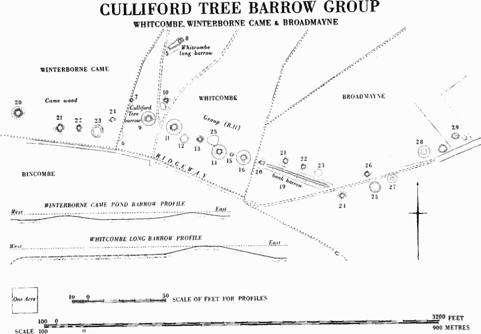
Culliford Tree Barrow Group
For profile of bank barrow, Broadmayne (19), see map of Ridgeway Area (in pocket).
(22) Bowl (?) (69738545) 53 yds. E. of (21). Diam. about 70 ft., ht. about 1½ ft.
(23) Pond barrow (69778543) 52 yds. E. of (22). Central depression, 46 ft. in diam. and about 8 ins. below ground level, is bounded by unbroken bank about 39 ft. wide and over 3 ft. high, with possible traces of external ditch about 20 ft. wide on W. and N. (see profile). Thickly overgrown but relatively well-preserved.
(24) Bowl (69828547) 50 yds. N.E. of (23). Diam. 70 ft., ht. 5½ ft.
Whitcombe:
(6) Pond barrow, possible (69838543), 60 yds. S.E. of last. Diam. about 120 ft. and bank up to 20 ft. wide. Cut by parish boundary. Now destroyed.
(7) Bowl (69868553), on parish boundary 105 yds. N.N.E. of (6). Diam. 45 ft., ht. 5 ft.
(8) Barrow (?) (69988567). Diam. 40 ft., ht. 5 ft., on top of N.E. end of long barrow, Whitcombe (5).
(9) Culliford Tree barrow, bowl (69918547), 70 yds. S.E. of (7). Diam. 94 ft., ht. about 13 ft., within tree-clump enclosure, still containing trees, first planted 1740 (Hutchins 1st. ed., I, 419). Large trench on S. and top almost certainly dug 1858 when four secondary extended inhumations, one with necklace of amber and two gold-plated beads, and cremation with incense cup in collared urn, were found (Wessex interment no. 7). Finds lost except for urn-sherd in D.C.M. Barrow became meeting place of Hundred to which it gave its name. (Hutchins II, 485; Abercromby II, 28 and fig. 235.)
(10) Bowl (69958552) 70 yds. N.E. of (9). Diam. 68 ft., ht. 7½ ft. Possibly one of two which yielded skeletons (G. Dugdale, William Barnes of Dorset (1953), 167).
(11) Ditched bowl (69978545) 80 yds. E.S.E. of (9). Diam. now 87 ft. but formerly about 100 ft., ht. about 12 ft. with flat top. Spread chalk outside ditch suggests bank.
(12) Pond barrow (69998543), now only slight depression about 65 ft. in diam. immediately S.E. of (11), surrounded by roughly circular chalk bank, about 15 ft. wide (V.A.P. CPE/UK 1821: 6443).
(13) Bowl (70038542) 40 yds. E. of (12). Diam. 72 ft., ht. 4½ ft. On E. probably just touches enclosure (25).
(14) Ditched bowl (70088538). Diam. about 100 ft., ht. 12½ ft., with ditch about 17 ft. wide probably cutting bank of enclosure (25) on N.W.
(15) Bowl (?) (70128538) immediately E. of (14). Diam. about 40 ft., ht. 1 ft. Markedly earthy, with no sign of chalk make-up or ditch.
(16) Ditched bowl (70158537) immediately E. of (15). Diam. now 75 ft., but formerly about 90 ft., ht. 12½ ft., with ditch about 17 ft. wide.
Broadmayne:
(20) Ditched bowl (70198536) overlying W. and smaller end of bank barrow (19) (see profile on map of Ridgeway Area (in pocket)). Diam. about 80 ft., ht. 11 ft. above ditch.
(21) Bowl (70268537) on apparent lip of N. ditch of bank barrow. Diam. about 70 ft., ht. about 6 ft.
(22) Bowl (70308535) immediately outside N. ditch of bank barrow and 50 yds. E.S.E. of (21). Diam. 73 ft., ht. 9 ft.
(23) Pond barrow, possible (70338534), 50 yds. S.E. of (22) and immediately outside N. ditch of bank barrow. Roughly circular about 50 ft. by 70 ft. and about 2 ft. deep with broad chalky spread on N.W. only (V.A.P. CPE/UK 1821: 6443).
(24) Ditched bowl (?) (70408528) about 30 yds. E.S.E. of E. end of bank barrow. Diam. 84 ft., ht. 12 ft. with possible ditch about 15 ft. wide.
(25) Pond barrow (70498528) 90 yds. E.N.E. of (24). Diam. about 60 ft., depth about 1½ ft. within unbroken bank about 15 ft. across and at most 6 ins. high.
(26) Bowl (70468533) 40 yds. N.N.W. of (25). Diam. about 84 ft., ht. about 11 ft.
(27) Ditched bowl (70538532) 50 yds. E.N.E. of (25). Overall diam. about 90 ft., ht. 1 ft.
(28) Ditched bowl (?) (70628537) 120 yds. N.E. of (27). Overall diam. about 90 ft. Ploughed almost flat.
(29) Bowl (70708542) 90 yds. N.E. of (28). Diam. about 82 ft., ht. 10 ft.
(AB) Group (SY 78 NW). Four barrows, including an oval barrow, in N.W.-S.E. line across S.-facing slope of low ridge running N.N.E. below the Ridgeway. All have been heavily ploughed. The top half of bank barrow Broadmayne (19) and the round barrows continuing its alignment to W. can be seen in silhouette to S.
(17) Ditched bowl (70708626). Diam. about 90 ft., ht. about 5 ft.
(18) Ditched bowl (70748620) 70 yds. S.E. of (17). Diam. 54 ft., ploughed almost flat.
(19) Ditched bowl (70768619) immediately S.E. of (18) and possibly forming double barrow with it. Diam. about 70 ft., ht. about 2 ft.
(20) Ditched oval barrow (70798617) 30 yds. S.E. of (19) and crossed, near E. end, by parish boundary with West Knighton. About 123 ft. long by 80 ft. within apparently continuous ditch; ht. 2½ ft. rising to 5 ft. beneath parish boundary where unploughed.
Four barrows (SY 78 NW), all ploughed, lie on continuation of same low ridge to N.E.
(21) Bowl (71078669). Diam. about 70 ft., ht. about 3 ft.
(22) Bowl (71008698). Diam. 45 ft., ht. 4½ ft.
(23) Ditched bowl (?) (71018701). Diam. 45 ft., ht. 4 ft.
(24) Bowl (71668756). Diam. about 72 ft., ht. about 7 ft.
Winfrith Newburgh
Most of the seventeen barrows lie on heathland N. of the village, five forming the Black Knoll Group (AC). Another barrow possibly existed at 81938295 (O.S. 1811). Some on Winfrith Down, perhaps including (32), were excavated by Durden but cannot now be identified (Durden Catalogue, 9, no. 110; 21, nos. 50–54).
(32) Bowl (?) (SY 88 SW; 80378317) on top of broad ridge. Diam. 42 ft., ht. 2 ft. Ploughed. There is now no trace of a second mound (on O.S. 1811) immediately to N.N.E.
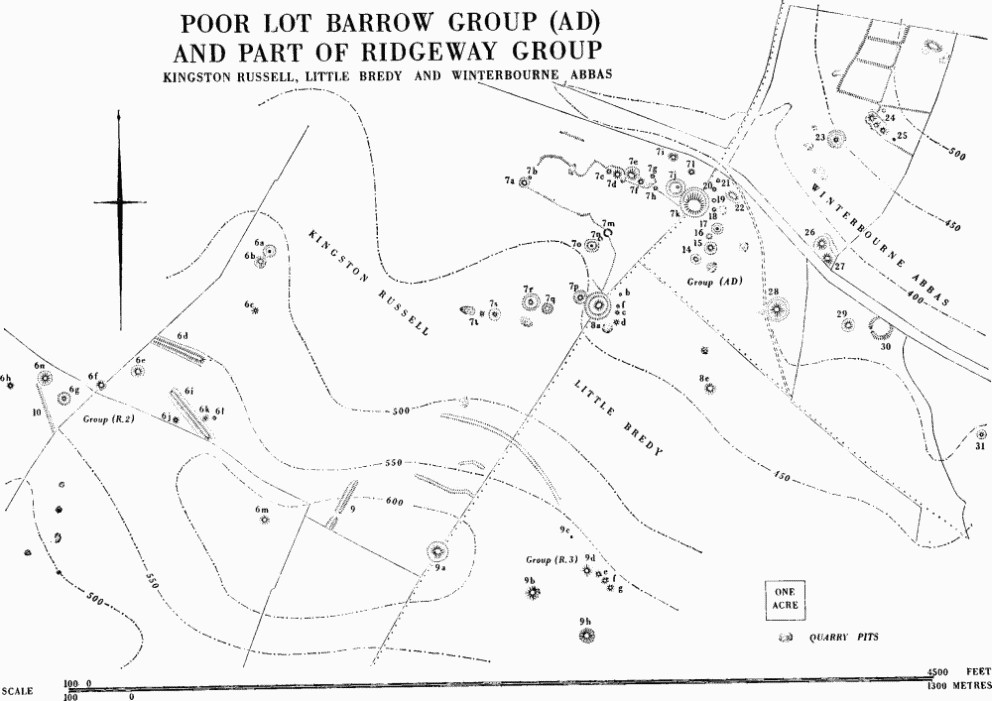
Poor Lot Barrow Group (AD) and Part of Ridgeway Group
(33) Bowl(?) (SY 88 SW; 81508334) on almost level hill top. Diam. about 60 ft., ht. 5 ft., where preserved in hedge bank. Rest ploughed out.
(34) Bowl (?) (SY 88 SW; 82298259) on crest of broad ridge. Diam. 72 ft., ht. 1½ ft. Ploughed.
(35) Bowl (?) (SY 88 SW; 82298263) 50 yds. N. of (34). Ploughed flat. (O.S. 1811; V.A.P. CPE/UK 1821: 2434.)
(36) Bowl (?) (SY 88 SW; 82298292). Ploughed flat. (O.S. 1811; V.A.P. CPE/UK 1821: 2434.)
(37) Bowl(?) (SY 88 SW; 82158395) on summit of ridge above slopes to N. and S. Diam. about 60 ft., ht. 1½ ft. Ploughed.
(38) Bowl (SY 88 NW; 80238603) on Drove Hill. Diam. 42 ft., ht. 3 ft.
(39) Bowl (SY 88 NW; 80368600) on slight knoll. Diam. 42 ft., ht. 2½ ft. Disturbed in centre.
(40) Mound, possible barrow (SY 88 NW; 80278623) on end of slight knoll. Diam. 48 ft., ht. 4 ft.
(41) Ditched bowl (?) (SY 88 NW; 80158641) on flat top of steep-sided knoll. Diam. 25 ft., ht. 4 ft. Disturbed in centre.
(AC) Black Knoll Group (SY 88 NW). Five bowl barrows on knoll rising from undulating heathland to just over 200 ft. above O.D. Much disturbed.
(42) Bowl (80608633). Diam. about 63 ft., ht. 8 ft. Trigonometrical station on top.
(43) Bowl (80628631) 21 yds. S.E. of (42). Diam. 33 ft., ht. 5 ft.
(44) Bowl (80658630) 30 yds. E.S.E. of (43). Diam. about 35 ft., ht. 5½ ft.
(45) Bowl (80668628) 20 yds. S.E. of (44). Diam. 33 ft., ht. 5 ft.
(46) Bowl (?) (80688627) 20 yds. S.E. of (45). Diam. 48 ft., ht. 8 ft.
(47) Ditched bowl (?) (SY 88 NW; 80488752) on Whitcombe Hill, a small but steep-sided knoll. Diam. 30 ft., ht. 2½ ft.
(48) Bowl (SY 88 NW; 80688747) at top of scarp falling from local plateau in heath. Diam. 30 ft., ht. 3 ft. Disturbed in centre.
Winterbourne Abbas
The parish contains forty-one barrows including four bell, three disc, one bell-disc and four pond barrows, probably two triple bowls and perhaps one double bell, making it one of the richest of Dorset parishes in special types of barrow. All but six of these barrows are part of, or related to, three groups on the S. of the South Winterborne valley. The largest concentration is in the S.W. corner of the parish, including part of the Poor Lot Group (AD) and two smaller groups, Three Barrow Clump (AE) and Longlands (AF), which lie on spurs projecting N. from the Ridgeway. The five bowls (48–52) scattered N. of the valley emphasise the barrow concentration to the S., though of all the groups immediately N. of the Ridgeway, the Poor Lot Group is the only one partly in a valley bottom. Despite the ploughing and damaging of many barrows, this remains one of the most impressive groups in the county.
(AD) Poor Lot Group (SY 59 SE; Fig. p. 460, Plate 210). Forty-four barrows lie around the junction of three parishes. Twenty are in Kingston Russell (Dorset I, 129), six in Little Bredy (ibid., 38), and eighteen, described below, in Winterbourne Abbas. Within the group, here considered as a whole, are seven bells, two (26–7) perhaps forming a double barrow, six disc and four, possibly five, pond barrows, two bell-disc barrows, two triple bowls, and twenty-two bowls. It lies nearly ½ mile N. of the Ridgeway on relatively low-lying ground which is, nevertheless, some 450 ft. above O.D., and near the head of a valley winding down to the E. The group includes two irregular but marked alignments (Kingston Russell (7c–k); Kingston Russell (7p–t) and Little Bredy (8a)) strung along the edges of a minor plateau jutting N.E. into the valley bottom from the foot of the Ridgeway. Kingston Russell (7a and b), though separated from these alignments, lie in a similar position on the N.W. edge of the plateau and, like the N. alignment, appear silhouetted on the plateau edge when viewed from the Ridgeway.
From the plateau, which drops sharply on all sides except the S.W., can be seen not only the other barrows in the group, but also the isolated Kingston Russell (6a–c), the two long barrows Kingston Russell (6d) and (6i), and the bank barrow Long Bredy (8) stretched across the end of Group R on Martin's Down, 1 mile to the W. All the barrows in the group, except Kingston Russell (7i) and (7l) and Winterbourne Abbas (20) and (21) on the N.-facing slope, are visible from the Ridgeway at Little Bredy (9a). All those on Fig. p. 460, as well as Long Bredy (8), are visible from the triple barrow (24).
Three barrows of rare types (Kingston Russell (7m, n and o)) are roughly in the centre of the plateau on nearly level ground forming a short alignment pointing in each direction to a disc barrow (Kingston Russell (7j and s)). The two pond barrows (Kingston Russell (7m, n)), excavated in 1952–3 and since almost obliterated, both contained pits and flint paving but no burials (Dorset Procs. LXXVI (1954), 89). The E. end of each of the major alignments is marked by a disc barrow, a large bell barrow and a short line of small barrows, mostly bowls, running across the axis of the major alignment. Outside this short line, at the E. end of the N. alignment, is a triple bowl barrow (22) just off the crest of the N.E. slope. A second triple bowl (24) lies, also just off the crest, on the S.W. slope on the other side of the valley. Below it is a disc barrow (23), clearly visible from the valley floor.
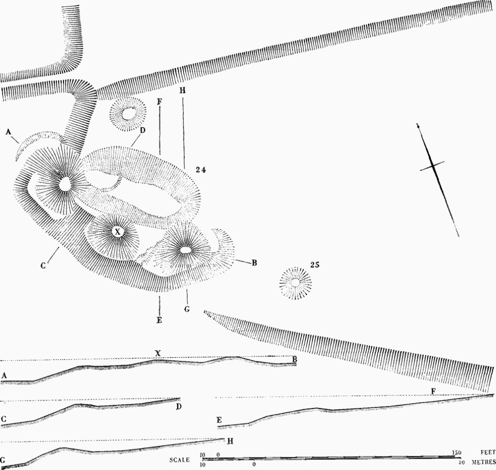
Triple barrow, Winterbourne Abbas (24), and adjacent remains in Poor Lot Barrow Group (AD).
On the narrow valley floor four barrows (26–7, 29–30) plausibly form a focus for the group, a suggestion supported by the position of another disc barrow (31) about 300 yds. to the S.E. on a N. W. slope visible from and dropping towards the four 'focal' barrows.
Despite the apparent importance of the group, no finds are recorded from it except a few sherds from Kingston Russell (7n and m), the only excavated barrows. The only certain relative date is that bell barrow Little Bredy (8a) is later than disc barrow Kingston Russell (7p) (Dorset I, xxxii, 129). Many of the barrows have now been damaged by ploughing, the smaller ones in particular appearing as flinty mounds. Some mounds were scraped up (e.g. (20) and (21)), others were from continuous ditches (e.g. (28)) and others were thrown up or down-hill from a ditch on one side or the other (e.g. (22)). A mound 2½ ft. high (LVG 8b) N.E. of (24) is almost certainly spoil from an adjoining pit.
Barrows (14–21) form a short line running roughly N.-S. across the axis of the N. alignment.
(14) Bell-disc (58919064) 97 yds. S. of Kingston Russell (7k). Diam. 31 ft., ht. 2 ft., with berm 6 ft. wide and ditch 12 ft. wide.
(15) Bell-disc (58949065) 34 yds. N.E. of (14). Diam. 24 ft., ht. 3½ ft., with berm 9 ft. wide, ditch 8 ft. wide and 1 ft. deep and outer bank 9 ft. wide.
(16) Pond barrow, possible (59829068), 40 yds. N. of (15). Diam. 33 ft., depth 1 ft., but no outer bank.
(17) Disc (58959069) on crest of E. slope, 19 yds. N.E. of (16). Total diam. about 70 ft. Diam. of central mound 21 ft., ht. 1½ ft., with berm 9 ft. wide, within ditch formerly 8 ft. wide and outer bank about 11 ft. wide.
(18) Bowl (?) (58949072) 35 yds. N. of (17). Diam. about 38 ft., ht. 6 ins.; until recent ploughing appearing as slight circular bank, probably due to unrecorded excavation.
(19) Bowl (?) (58949074) about 15 yds. N. of (18). Formerly about 30 ft. in diam., now destroyed.
(20) Bowl (58949076) 36 yds. N. of (18) on N.E. slope. Diam. 20 ft., ht. 1 ft.
(21) Bowl (58959077) 17 yds. N.N.E. of (20) near foot of slope. Diam. 21 ft., ht. 9 ins.
(22) Ditched triple bowl (58979074) on N.E. slope 38 yds. S.E. of (21). Irregular elongated mound about 70 ft. long, up to 48 ft. broad and 6 ft. high at E., higher, end. Three separate crests show in profile, and ditch 10 ft. wide runs along S.W., uphill, side.
(23) Disc (59159083) across valley from (22) on S.W. slope of 9°. Overall diam. about 100 ft. Diam. of mound 33 ft., ht. 1½ ft. but disturbed. Berm, ditch and outer bank each about 12 ft. wide; ditch 1 ft. deep and bank 1 ft. high. Bank ploughed away on S.E.
(24) Ditched triple bowl (?) (59219085; Plate 210) on false crest of S.W. slope above and 77 yds. N.E. of (23), apparently on lynchet of 'Celtic' field. Appears as undulating and slightly curving bank about 160 ft. long with three arcs in plan on S.W. side and three crests in profile of mounds about 40 ft., 35 ft. and 35 ft. in diam., from N.W. to S.E. Hts. of mounds 6 ft., 7 ft. and 5 ft. respectively, though much greater from downhill side (see profiles). Steep ridge-shaped mound joins W. and central mounds but junction between central and E. mounds much disturbed. On S.W. are remains of possible berm. Shallow elongated depression on N.E. is probably a quarry ditch and has been dug through surface of 'Celtic' field. Ditch about 12 ft. wide also at foot of barrow on N.W.
(25) Mound, possible bowl (59259083) 24 yds. S.E. of E. mound of (24), inside, and presumably later than, 'Celtic' field. Diam. 20 ft., ht. 6 ins.
(26) Bell (59129066) at foot of slope 233 yds. S.S.W. of (24). Diam. 60 ft., ht. 7 ft., with berm and ditch each about 15 ft. wide. Perhaps forms double bell with (27).
(27) Bell (59139064) immediately S.E. of (26). Diam. 60 ft., ht. 7 ft. Apparently shares ditch with (26) on N.E., but disturbed on S. and E.
(28) Bell (59049055) 130 yds. S.W. of (27). Diam. about 90 ft., ht. 11 ft., with berm about 9 ft. wide and ploughed ditch about 12 ft. wide. (28) and (29) are aligned on the entrance of (30).
(29) Ditched bowl (59169053) in woodland 125 yds. E.S.E. of (28). Diam. 52 ft., ht. 6½ ft., with ditch about 10 ft. wide.
(30) Pond barrow (59219052) in woodland 57 yds. E. of (29). Depression 86 ft. in diam., and generally 1 ft. deep; enclosing bank 18 ft. to 24 ft. across, 3½ ft. high from outside and up to 5½ ft. high above centre of interior. Break 12 ft. wide in bank on S.W. is probably original. The N.E. segment of bank, cut away by modern road, shows much flint in section.
(31) Disc (59389033) on N.W. slope tilting towards (30) and 260 yds. S.E. of it, in similar position to (23). Diam. of mound 32 ft., ht. 1 ft., with remains of berm about 5 ft. wide, ditch 10 ft. wide and possible outer bank. Ploughed almost flat.
(32) Pond barrow (SY 59 SE; 59579038) on the valley floor like (30) and 25 yds. E. of the Broad Stone (Stones, Winterbourne Abbas (56)). Overall diam. about 96 ft. with slightly sunken interior about 42 ft. in diam. surrounded by flinty bank about 27 ft. wide and 1½ ft. high. Break 12 ft. wide in bank on S.S.W. is probably original. N. half destroyed by road and S. half ploughed.
(AE) Three Barrow Clump Group (SY 59 SE). Ten barrows, including one, possibly two, bells and one pond barrow, on the top and N. slope of a spur on S. side of S. Winterborne valley. Most have been damaged.
(33) Ditched bowl (?) (59489003) on ridge top in woodland and crossed by parish boundary with Little Bredy. Diam. about 60 ft., ht. about 5½ ft.
(34) Ditched bowl (?) (59569010) 130 yds. N.E. of (33). Diam. about 40 ft. Ploughed almost flat.
(35) Ditched bowl (?) (59579014) 35 yds. N. of (34). Diam. 15 ft., ht. 9 ins., with ditch 6 ft. wide.
(36) Ditched bowl (59659023) on N. slope 110 yds. N.E. of (35). Diam. 18 ft., ht. 1 ft., with ditch about 6 ft. wide.
(37) Ditched bowl (59729021) 70 yds. E.S.E. of (36). Diam. 62 ft., ht. 7 ft., with berm-like feature, possibly spoil, on S. Ditch 12 ft. wide and 1 ft. deep, filled on N. with spoil from central excavation.
(38) Bowl (59739023) 25 yds. N.E. of (37). Diam. 21 ft., ht. 1½ ft.
(39) Bowl (59749023) immediately adjacent E. of (38). Diam. about 22 ft., ht. 1½ ft.
(40) Bell (?) (59769018) 55 yds. S.E. of (39). Mound quarried away leaving disturbed area surrounded by ditch 85 ft. in diam., 11 ft. wide and 2 ft. deep, itself dug away on E. where probably cut by ditch of (41).
(41) Bell (59809018) immediately adjacent to (40) on E. and probably later than it. Diam. 73 ft., ht. 10 ft., with berm 9 ft. wide and ditch 13 ft. wide and 2 ft. deep.
(42) Pond barrow (59829020) 33 yds. N.E. of (41). Overall diam. 59 ft. Central depression 35 ft. in diam. and 6 ins. deep, surrounded by bank 12 ft. wide and 1 ft. high. (AF) Longlands Group (SY 58 NE, 68 NW). Five barrows, including one possible bell, four in a rough alignment S.W.-N.E. along spine of spur, with possible long barrow (Winterbourne Abbas (13)) at N.E. end. The three S.W. barrows are just above the 500 ft. contour and the others above 400 ft. All damaged. Near foot of steep slope to N. immediately S. of the main road three further barrows at 60449020, 60519025 and 60559018 are shown on O.S. (1811) but there is now no sign of them.
(43) Bowl (?) (59998977) in Dry Wood, now only irregular rise about 9 ins. high.
(44) Bowl (60008978) 25 yds. N.E. of (43) also in Dry Wood. Diam. 48 ft., ht. 3½ ft.
(45) Ditched bowl (60038980) 40 yds. N.E. of (44). About 65 ft. in diam. and 1½ ft. high, within oval ditch about 150 ft. (N.W.-S.E.) by 90 ft. (V.A.P. CPE/UK 1934: 5098). Almost ploughed out.
(46) Bowl (60188993) 220 yds. N.E. of (45). Diam. 52 ft., ht. 14 ft., though base steepened by ploughing.
(47) Bell (?) (60478995) 307 yds. E.N.E. of (46). Diam. about 94 ft., ht. 5 ft., with ditch about 105 ft. in diam., separated from mound by narrow berm (V.A.P. CPE/UK 1934:5092).
(48) See Big Wood Group (AQ), Winterbourne Steepleton, p. 472.
(49) Bowl (SY 59 SE; 59629181) in extreme N.W. of parish just off ridge top. Diam. about 54 ft., ht. 4 ft. Ploughed.
(50) Bowl (SY 69 SW; 60109084) near summit of spur on slight S.W. slope. Diam. about 45 ft., ht. 1½ ft. Ploughed.
(51) Bowl (?) (SY 69 SW; 61529162) on summit of ridge above 500 ft. Slightly oval, measuring 38 ft. by 34 ft., ht. 3 ft. Ploughed.
(52) Bowl (SY 69 SW; 61669148) 200 yds. S.E. of (51) on slight S.E. slope. Diam. 25 ft., ht. 2 ft.
(53–4) See Pound Hill Group (AU), Winterbourne Steepleton, p. 473.
Winterborne Came
There are thirty-nine barrows in the parish, fifteen (10–24) in Group R and described under other parishes.
The S. end of the parish also includes the spur where twelve barrows on and near the Golf Course form the Came Down Group (AG). Fourteen others are scattered on the lower slopes to the N., mainly related to a long spur above the 300 ft. contour. Most have been disturbed and damaged.
(10–17) See Bincombe Down Group (R.9), p. 438.
(18–19) See Bincombe Hill Group (R.10), p. 439.
(20–4) See Culliford Tree Group (R.11), Whitcombe, p. 458.
(AG) Came Down Group (SY 68 NE). Eleven barrows, including a double bowl, a probable bell and a disc barrow, associated with a 'ring-work', on and near Came Down Golf Course on top of a spur running N.E. from the Ridgeway. The focus of the group is a cluster including the disc, the double bowl, a large bowl barrow and the associated small banked enclosure (see Enclosures, Winterborne Came (49)). Although somewhat altered by the needs of the golf course, the group as a whole is well-preserved and one of the few still under grass (but cf. Dorset Procs. XXIV (1903), pp. XXV and xliii).
Warne recorded the destruction of a barrow 'of immense size' which is probably (35). In it and on its S.E. side were found two inhumations accompanied by parts of antlers some 10 ft. from the surface; 3 ft. to 4 ft. below were two grooved bronze daggers, the longer probably with six rivets, the shorter apparently tanged.
(25) Bowl (68528607) on W. slope of spur. Diam. 72 ft., ht. 5 ft., but spread.
(26) Mound, possible bowl (68398615), 170 yds. N.W. of (25). Perhaps originally elongated, now almost destroyed by bunker.
(27) Bowl (68648616) on slight W. slope 175 yds. N.E. of (25). Diam. 64 ft., ht. 4½ ft. Bunker cuts S. side.
(28) Ditched double bowl (68668621) 25 yds. N.E. of (27). The almost contiguous mounds, 56 ft. in diam. and 4 ft. high, are joined by a broad saddle 1 ft. high. The whole surrounded by oval ditch.
(29) Disc (68718627) on slight W. slope 75 yds. N.E. of N. mound of (28). The oval tump, 30 ft. by 24 ft. and 6 ins. high, is about 6 ft. S. of centre on slightly raised interior 102 ft. in diam., surrounded by bank 26 ft. wide and 1 ft. high and slight external ditch only.
(30) Ditched bowl (68678629) 48 yds. N.W. of (29) on W. slope. Diam. 70 ft., ht. 6½ ft. with ditch 12 ft. wide and 1 ft. deep.
(31) Bowl (68788624) 70 yds. S.E. of (29) on centre of spur. Diam. 79 ft., ht. 4½ ft. Ht. slightly increased for use as tee. Cut on S. by bunker.
(32) Ditched bowl (68818626) immediately E. of centre of spur 50 yds. N.E. of (31). Diam. 101 ft., ht. 9 ft. with ditch 15 ft. wide and 2 ft. deep.
(33) Bowl (68868635) 110 yds. N.N.E. of (32) on N.W. slope. Diam. about 35 ft., ht. 1½ ft. Much spread.
(34) Bowl (?) (69038641) on E. side of Down Wood 270 yds. N.E. of (33). Diam. 42 ft., ht. 1½ ft. Tree-covered.
(35) Bell (?) (69148651) 160 yds. N.E. of (34). Diam. 100 ft., ht. 2 ft., but flattened by ploughing. Probably within ditch about 140 ft. in diam., suggested by air photograph CPE/UK 1934: 1058.
(36) Bowl (SY 68 NE; 68848690) on N. slope near W. parish boundary. Diam. 77 ft., ht. 6 ft.
(37) Bell (SY 68 NE; 68878690) 43 yds. E.S.E. of (36). Diam. 87 ft., ht. 7 ft., with ditch 15 ft. wide, destroyed on E. Berm visible only on S. and perhaps on W. Top of mound used as golf tee. Probably excavated in 1882 by Cunnington who found a few worked flints and a near-central cremation in a chalk-cut hollow 6 ins. deep, dug apparently beside the pyre (Dorset Procs. XXXVII (1916), 43).
Within Cripton Wood about 600 yds. E. of (35) are three barrows roughly in line (SY 68 NE). The westernmost is a bell.
(38) Bell (69638657) on slight E. slope at W. end of wood. Diam. 54 ft., ht. 4½ ft., with berm 12 ft. wide and ditch 12 ft. wide and 1 ft. deep.
(39) Ditched bowl (69738654) 130 yds. E. of (38). Diam. 33 ft., ht. 3 ft. Damaged by rabbits.
(40) Bowl (69758654) 30 yds. E. of (39). Diam. 21 ft., ht. 1½ ft.
(41) Bowl (?) (SY 78 NW; 70378648) on W. slope of spur near parish boundary with Whitcombe. Now oval, 55 ft. N.-S. by 80 ft. E.-W., owing to ploughing; ht. 1½ ft.
(42) Bowl (?) (SY 78 NW; 70408652) 50 yds. N.E. of (41). Diam. from 82 ft. to 98 ft. owing to ploughing; ht. 2½ ft.
(43) Bowl (?) (SY 68 NE; 69498750). Forms a pair with (44) on W. of parish, on W. edge of broad ridge. Diam. 60 ft., ht. 2 ft. Ploughed.
(44) Bowl (?) (SY 68 NE; 69538750) 45 yds. E. of (43). Diam. 86 ft., ht. 2½ ft. Ploughed.
(45) Bowl (?) (SY 68 NE; 69818703) on col between two combes. Diam. about 58 ft. Ploughed almost flat.
(46) Bowl (?) (SY 78 NW; 70128692) on S. slope below 300 ft. contour N.W. of Cripton Barn. Diam. 57 ft. Ploughed almost flat.
(47) Bowl (?) (SY 78 NW; 70128685) 75 yds. S. of (46). Diam. 75 ft. Ploughed almost flat.
(48) Pond barrow, possible (SY 78 NW; 70178688), 46 yds. N.E. of (47). Regular and slightly oval depression 53 ft. by 57 ft. and 1½ ft. deep. No outer bank.
Winterborne Herringston
The parish, consisting mainly of relatively low ground N. of the Ridgeway, contains only four barrows. (3) and (4) at the narrow S. end of the parish, where it includes a projecting spur of the Ridgeway, form the N.E. end of a straight alignment 930 yds. long with Bincombe (30–1) and (33).
(3) Bowl (?) (SY 68 NE; 68118650). Diam. 61 ft., ht. 1 ft. Ploughed.
(4) Bowl (SY 68 NE; 68168659) 100 yds. N.N.E. of (3). Diam. 63 ft., ht. 2½ ft. Ploughed.
(5) Bowl (SY 68 NE; 68498843) on W.-E. ridge above 300 ft. Diam. 38 ft., ht. 5½ ft. Slightly flattened on top and crossed by boundary with former parish of Fordington.
(6) Herringston Barrow, bowl (?) (SY 68 NE; 68548844), 60 yds. E. of (5). Diam. about 77 ft., ht. 6 ft. Much damaged, and crossed by same boundary as (5). Opened in 1880 by Cunnington who found a primary (?) contracted inhumation under a cairn, in which was possibly a cremation with part of a flint or stone axe.
Winterborne Monkton
There are six round barrows, three of them in Lanceborough Group. The others (including two overlapping disc (?) barrows) point N.N.W. approximately towards the E. end of the Maiden Castle 'long mound'. Two unlocated barrows have been excavated. One in Fordington Field contained a cremation in a small biconical urn covered by a flat stone in a cist (Arch. XXX (1844), 334, no. 19; Warne, C.T.D., tovp, no. 81); the other (C.T.D., tovp, no. 62), conceivably (8), contained four inhumations at a depth of 20 ft. towards the centre. A central cist contained an inurned cremation covered by a stone. A perforated boar's tusk was probably with the inhumations and raspberry seeds, allegedly from remains of the stomach of one of them, were subsequently reported as having produced plants and fruit. In the upper part of the barrow were two more inhumations above an inurned cremation with a probable bone pin.
(AH) Lanceborough Group (SY 68 NE; Fig. p. 494). Four barrows including two bells and a possible bell, with a long barrow and a horseshoe-shaped enclosure (Winterborne Monkton (4, 11), lie on a local downland crest about 300 ft. above O.D. some 700 yds. N. of the W. end of the Maiden Castle 'long mound' (Long Barrows, Winterborne St. Martin (23)). A probable small barrow (LVG 1d) towards S. end of dyke (Winterborne Monkton (12)) is not traceable. The adjacent open field furlong was called Lanceborough or Great Barrow Furlong (Tithe Map, 1844), a name probably referring to (6), the largest bell barrow in the area covered by this Volume. All the barrows have been damaged, mostly by ploughing.
Winterborne St. Martin:
(137) Bowl (?) (66508937). Diam. uncertain, ht. 3 ft. Opened by Cunnington who found nothing.
Winterborne Monkton:
(5) Bell, possible (66538924), 110 yds. S.S.E. of last. Diam. about 75 ft., with berm about 15 ft. wide and ditch 10 ft. to 12 ft. wide; on E., ditch almost touches S.W. end of ditch of long barrow (4). Ploughed flat, visible as soil-mark.
(6) Bell (66698928) 160 yds. E. of (5). Diam. about 130 ft., ht. 21 ft., with sloping berm about 20 ft. wide. Ditch about 37 ft. wide and 2 ft.-3½ ft. deep. A stone cist containing an inhumation, probably Roman, with head to E. was found in top of mound (D.C.C., 14 Aug. 1862).
(7) Bell (66778927) 90 yds. E. of (6). Diam. about 76 ft., ht. 5½ ft. Berm about 9 ft. wide and ditch 15 ft. wide.
Three barrows (SY 68 NE; Fig. p. 494; Plate 214), E. of Maiden Castle 'long mound' (Winterborne St. Martin (23)), noted by Skinner in 1829 (B.M. Add. MS. 33715, 2–10) but now virtually destroyed. A fourth, smaller, barrow possibly existed between (8) and the outer bank of Maiden Castle (Cambridge University O.A.P. TC 12).
(8) Barrow (?) (67488822) on slope of ridge 450 yds. E.S.E. of E. end of 'long mound'. Circular bank about 60 ft. in diam. Visible only as crop-mark on air photograph.
(9) Disc (?) (67528819) about 60 yds. E.S.E. of (8). Central mound about 60 ft. in diam. and 1½ ft. high surrounded by ditch and external bank about 150 ft. in diam. Cut by (10).
(10) Disc (?) (67548818) overlapping (9) on E.S.E. Apparently similar in size and type, its ditch and external bank cut bank, ditch and berm of (9).
Winterborne St. Martin
There are 118 round barrows, more than in any other parish in Dorset. The greatest concentration is along the S. edge of the parish where it runs up on to the Ridgeway to include the Bronkham Hill and Ridge Hill Groups (R.6 and R.7), with further groups - e.g. Eweleaze Barn (AJ) and Four Barrow Hill (AK) - on spurs projecting N. A scatter of barrows, including Group (AM) N. and W. of Rew, lies on the high ground followed by the Roman road running W. from Dorchester in the N. of the parish.
The Bronkham Hill Group, now one of the bestpreserved groups in the county, is a good example of the sky-line siting of barrows (Plate 210). The parish includes several remarkable barrows: the huge bell-disc (67) in its S.E. corner; the large and well-preserved bell (75) beside a double bowl (76) on Shorn Hill, and the large Clandon barrow (134). Many have been excavated, chiefly by Warne, Sydenham and E. Cunnington in the 19th century. Finds are particularly rich, including the remarkable series of probably secondary deposits from (134). Flint cairns in barrow mounds are especially a feature of Groups (AM–AO). Among excavated barrows impossible to identify is one 'south of Martinstown' from which was ploughed a grooved bronze dagger with three rivets (Dorset Procs. LII (1930), xlvii).
(R.6) Bronkham Hill Group (SY 68 NW; Fig. p. 519, Plates 209–10). Thirty barrows, including four bells and one double bowl, in a mile-long linear cemetery running N.W.-S.E. Nearly all are on top of the Ridgeway, often related to localised small spurs or knolls projecting from the narrow gravel-capped and heath-covered ridge. At least three other small stony mounds on the ridge appear to be artificial and might be barrows. Numerous steep-sided, round-mouthed pits, apparently solution hollows in the gravel capping, lie amongst the barrows, sometimes in their ditches. The group includes Portesham (39–40).
(24) Ditched bowl (?) (62038742) on N.E. slope, 120 yds. S.E. of junction of parish boundary with Winterbourne Steepleton. Diam. 20 ft., ht. 1 ft.
(25) Bowl (62098740) on lip of steep N.E. slope, 70 yds. S.E. of (24). Diam. 27 ft., ht. 3 ft.
(26) Bowl (62128738) on lip of same slope 45 yds. S.E. of (25). Diam. 28 ft., ht. 3 ft.
(27) Bowl (62178736) on edge of short drop to E., 52 yds. S.E. of (26). Diam. 22 ft., ht. 3½ ft.
(28) Bowl (?) (62168730) 70 yds. S. of (27). Oval, 50 ft. (N.-S.) by 36 ft. Ht. 2 ft. Flat-topped.
(29) Bowl (62288731) on top of short S.-N. spur 150 yds. S.E. of (27). Diam. 31 ft., ht. 3 ft. Damaged, showing stony interior. 24 yds. to the N. is small, probably artificial, stony mound 10 ft. in diam. and 6 ins. high.
(30) Ditched bowl (62318724) just off spine of Ridgeway at head of combe running up from N. and 60 yds. S.E. of (29). Diam. 36 ft., ht. 2 ft., with ditch 10 ft. wide and 1 ft. deep. Flat, slightly hollowed, top.
(31) Bowl (62378737) on top of broad spur sloping down to N., 150 yds. N.N.E. of (30). Diam. 42 ft., ht. 2 ft. Much damaged.
(32) Bowl (62398731) 70 yds. S.S.E. of (31) on same spur. Diam. 33 ft., ht. 2½ ft. Much damaged.
(33) Bell (62378717) on small spur sloping down to N., 160 yds. S.E. of (29). Diam. about 70 ft., ht. above berm 7 ft.; berm at most 10 ft. wide, ditch up to 15 ft. wide and 2 ft. deep. Three solution hollows in ditch.
(34) Bowl (62418715) 50 yds. S.E. of (33). Diam. 36 ft., ht. 2 ft. Disturbed.
(35) Bowl (62518708) 130 yds. S.E. of (34). Diam. 18 ft., ht. 1½ ft.
(36) Bowl (62508702) 47 yds. S. of (35). Diam. 28 ft., ht. 1½ ft.
(37) Double bowl (62548703) on flat ground 40 yds. S.E. of (36). Mounds, respectively 25 ft. and 40 ft. in diam., and 2½ ft. and 3½ ft. high, are joined by a slight bank 1 ft. high.
(38) Bowl (?) (62568706) 20 yds. N. of (37). Diam. 18 ft., ht. 1 ft.
(39) Bowl (?) (62628699) 90 yds. S.E. of (37). Oval, 21 ft. (N.-S.) by 17 ft. Ht. 2 ft. Steep-sided.
(40) Bowl (62638694) 50 yds. S.S.E. of (39). Diam. 50 ft., ht. 4 ft. About halfway between it and (39) is small, possibly artificial, stony mound 15 ft. by 10 ft.
(41) Bowl (62648692) 35 yds. S.E. of (40). Diam. 45 ft., ht. 2 ft. Disturbed.
(42) Ditched bowl (62678689) 27 yds. S.E. of (41). Diam. 21 ft., ht. 2 ft. Ditch 3 ft. wide. Steep-sided.
(43) Bell (62708687) 45 yds. S.E. of (42). Diam. 92 ft., ht. now about 14 ft., but originally probably about 10 ft. only. Apparently has two berms, but upper probably result of spoil from N.-S. excavation trench 18 ft. wide through centre of mound. Lower berm 20 ft. wide at most, with stone mound 15 ft. in diam. and 1 ft. high on it on E. Ditch 21 ft. wide and 3 ft. deep.
(44) Ditched bowl (62738703) 176 yds. N.N.E. of (43) and down slope from it at head of combe. Diam. 45 ft., ht. up to 3 ft. Ditch 12 ft. wide, but ploughed.
(45) Bowl (62738684) 60 yds. S.E. of (43). Diam. 45 ft., ht. 4½ ft.
(46) Bowl (62768682; Fig. p. 519) 40 yds. E.S.E. of (45). Diam. 28 ft., ht. 3 ft. Cut on W. by a hedge bank which crosses dyke Winterborne St. Martin (145); (cf. (47)).
(47) Ditched bowl (62798681; Fig. p. 519, Plate 209) on edge of steep drop to N.E., 25 yds. S.E. of (46). Diam. 72 ft., ht. 7 ft. Ditch 12 ft. wide and 2 ft. deep. The dyke, Winterborne St. Martin (145), runs over top of mound.
(48) Bell (62828679) 45 yds. E.S.E. of (47). Diam. 68 ft., ht. 6 ft., with berm 7 ft. wide at most. Ditch up to 9 ft. wide and 1 ft. deep.
(49) Bell (62938674) 135 yds. E.S.E. of (48). Diam. 74 ft., ht. 11 ft., with berm up to 9 ft. wide. Ditch about 18 ft. wide. Damaged, with flattened top.
(50) Ditched bowl (63168665) on slight knoll with steep drop to N., 275 yds. E.S.E. of (49). Diam. 80 ft., ht. 10 ft. Ditch about 8 ft. wide. Disturbed.
(51) Bowl (63258665; Fig. p. 507) at head of steep drop to N., 85 yds. E. of (50). Irregular, with diam. about 22 ft., and ht. 2 ft.
Portesham:
(39) Bowl (?) (63308662; Fig. p. 507) 70 yds. S.E. of last. Irregular, with diam. 33 ft., and ht. 3 ft. Ploughed almost flat. It is within enclosure Winterborne St. Martin (143).
(40) Bowl (?) (63508665) 220 yds. E.N.E. of (39). Oval, flinty mound 39 ft. by 20 ft. and 2 ft. high.
(R.7) Ridge Hill Group (SY 68 NW, NE). Thirty-eight barrows including one bell, four probable bells, one very large bell-disc barrow and one pond barrow, many of them having survived intact in an area extensively covered with 'Celtic' fields (see Ancient Field Group (6), and Fig. p. 626). Ridge Hill continues the Ridgeway to the E. for the next 1¾ miles to the great Ridgeway bell-disc barrow (67). The Ridgeway here is domed on top, and the barrows lie in an irregular line, mostly on the highest ground. The group includes Portesham (41–2), Weymouth (396–406) and Bincombe (13–21). Weymouth (396–404) have all been heavily ploughed and six of them were opened by E. Cunnington between 1884 and 1888, including (403), his 'Ridgeway 7'.
Winterborne St. Martin:
(52) Bell (63818686) 650 yds. E.N.E. of (51). Diam. 74 ft., ht. 12 ft., with berm 12 ft. wide. Ditch about 24 ft. wide and 1 ft. deep. Damaged.
(53) Bowl (63858686) 50 yds. E. of (52). Diam. 34 ft., ht. 3 ft. Depression 24 ft. in diam. and 3 ft. deep lies at foot of mound on N.
(54) Bowl (63958680) 120 yds. E.S.E. of (53). Diam. 90 ft., ht. 8 ft.; N.-S. excavation trench across centre. Half mace-head of palaeozoic quartzite found on mound (P.P.S. XVIII (1962), 244, no. 59).
(55) Bowl (64018679) 75 yds. E.S.E. of (54). Diam. 46 ft., ht. 4 ft.
(56) Bowl (64068676) 60 yds. E.S.E. of (55). Diam. 30 ft., ht. 3 ft. Damaged.
(57) Ditched bowl (64248674) 190 yds. E. of (56). Diam. 79 ft., ht. 11 ft. Ditch about 25 ft. wide on E. Excavated in centre.
(58) Ditched bowl (64298674) 50 yds. E. of (57). Diam. 77 ft., ht. 11½ ft. Ditch about 15 ft. wide. N.-S. excavation trench through centre. Bank and ditch run up to it from N.
(59) Ditched bowl (64388674) 100 yds. E. of (58). Diam. 38 ft., ht. 3 ft. Ditch 10 ft. wide. Ploughed.
Portesham:
(41) Bell (?) (64578669) 200 yds. E.S.E. of last. Diam. 71 ft., ht. 10½ ft.
(42) Bell (?) (64598668) 45 yds. E.S.E. of (41). Diam. 62 ft., ht. 10½ ft.
Winterborne St. Martin:
(60) Bowl (64898676) 330 yds. E.N.E. of last on highest point along this stretch of Ridgeway. Diam. 87 ft., ht. 6 ft. Ploughed.
(61) Bowl (65058672) 180 yds. E.S.E. of (60). Diam. about 30 ft. Ploughed flat.
(62) Bowl (65178670) 140 yds. E. of (61). Diam. 37 ft., ht. 4½ ft. Ploughed, and excavated in centre.
Weymouth:
(396) Bowl (?) (65298659) 180 yds. S.E. of last. Completely destroyed.
(397) Bowl (?) (65338658) 40 yds. E.S.E. of (396). Diam. about 60 ft. Ploughed almost flat.
(398) Bowl (65368657) 30 yds. E.S.E. of (397). Diam. 70 ft., ht. 3 ft. Contained a cremation beneath inverted urn in an ash-filled pit, and a secondary cremation.
(399) Bowl (65398657) 30 yds. E. of (398). Diam. 72 ft., ht. 2 ft.
(400) Bowl (65438661) 55 yds. N.E. of (399). Diam. 104 ft., ht. 5½ ft. Contained incomplete inhumation under cairn 8 ft. to 10 ft. in diam. and 3 ft. high, on edge of pre-existing 'pond'. Probably associated were an inverted beaker, a flint scraper and two fragments of saddle querns.
(401) Ditched bowl (?) (65588660) 165 yds. E. of (400). Diam. 75 ft., ht. 3 ft.; probably with ditch about 90 ft. in diam., suggested by V.A.P. CPE/UK 1934: 1062. Contained only ashes and 5 small worked flints.
(402) Bell (?) (65678661) 100 yds. E.N.E. of (401). Diam. about 100 ft., ht. 7 ft. Berm and ditch each about 10 ft. wide suggested by V.A.P. CPE/UK 1934: 1062. Excavation produced evidence of burning but no burial.
(403) Bowl (65748662) 75 yds. E. of (402). Now only an irregular mound 9 ft. high immediately W. of reservoir, in 1885 it was 114 ft. in diam. and 13 ft. high. A primary inhumation in a Portland Stone cist in a pit was covered with a cairn 13 ft. in diam. and 7 ft. high. In and around the cairn were a bone dagger pommel, a bone needle, animal bones, and many flint implements including a flint mace-head, a polished flint axe and part of another, a flint saw, and scrapers. An inhumation with a three-riveted bronze dagger, and a nearby cremation, were in the upper part of the cairn under two layers of stone slabs. In the top of the mound was a secondary cremation with three grooved and riveted daggers —one of copper and two of bronze—gold mountings for a dagger pommel, traces of wooden sheaths and a small flanged copper axe with a small piece of fine cloth adhering to it. This is Wessex interment no. 20, one of the richest grave groups in Dorset. Surviving finds in D.C.M. (Dorset Procs. LVIII (1936), 20–5; P.P.S. XVI (1950), 133, pl. XIV, 2; ApSimon 54 and 56, nos. 2, 9, 10; Archaeometry, 4 (1961), 47, nos. 37 and 47.)
(404) Bowl (65858661) 130 yds. E. of (403). Diam. 90 ft., ht. 5 ft. Contained burnt material, including bone and several flint scrapers.
Winterborne St. Martin:
(63) Bowl (66038664) on N. slope 190 yds. E. of last. Diam. 60 ft., ht. 3½ ft. Ploughed. Oval depression, 60 ft. (N.-S.) by 45 ft. and 3 ft. deep, touches W. side.
(64) Barrow (?) (66158664) 130 yds. E. of (63) and in direct line between it and (67). Circular ditch about 100 ft. in diam. and 15 ft. wide visible on V.A.P. CPE/UK 1934: 1062. Ploughed flat.
(65) Bowl (66228658) 220 yds. E.S.E. of (63). Diam. about 50 ft. Ploughed flat.
(66) Ditched bowl (66278656) 60 yds. E.S.E. of (65). Diam. 60 ft., ht. 9 ft. Ditch about 9 ft. wide. Damaged.
(67) Bell-disc (66328666) 112 yds. N.N.E. of (66) and crossed by parish boundary. On N. slope just off highest ground, it lies at E. end of line of eleven barrows and is clearly visible on the sky-line from 'long mound' (23) in Maiden Castle. Mound is 79 ft. in diam. and 8 ft. high, with possible surrounding ditch about 10 ft. wide at its foot. Berm varies in width from 51 ft. on N. to 57 ft. on S. Outside an unbroken surrounding ditch 18 ft. wide and 2 ft. deep is a bank 15 ft. wide and 2 ft. high with modern breaks. Total external diam. about 250 ft., though E. third of berm, outer ditch and bank, formerly in Upwey and now in Bincombe, has been ploughed. Top of mound slightly disturbed. The whole monument is exceptional in its size and proportions. On S.E. is an almost straight alignment 230 yds. long formed by (66) and Bincombe (13, 15 and 16) (LVG, plate III).
Bincombe:
(13) Ditched bowl (66368658) 100 yds. S.E. of last. Diam. 96 ft., ht. 12 ft., probably with original chalk capping. Ploughed. (LVG, plate III.)
(14) Ditched bowl (66388662) 33 yds. N.N.E. of (13). Diam. about 40 ft., with ditch about 10 ft. wide, visible on V.A.P. CPE/UK 1934: 1061. Ploughed almost flat. Probably contained primary (?) cremation covered by stone slabs.
(15) Bell (?) (66428660) 45 yds. E. of (14). Diam. about 45 ft., ht. 2½ ft., apparently surrounded by ditch about 80 ft. in diam. visible on V.A.P. CPE/UK 1934: 1061. Now ploughed out. Contained an incomplete primary inhumation in cist under flint layer.
(16) Bowl (66468661) 50 yds. N.E. of (15). Diam. about 50 ft., ht. 2½ ft. Ploughed. Contained cairn of large stones covering primary (?) contracted male inhumation with a cremation near its feet and a bucket urn, now in D.C.M., near its head.
(17) Bowl (66508660) 55 yds. E.S.E. of (16). Diam. about 30 ft. Ploughed out.
(18) Ditched bowl (?) (66518650) 105 yds. S. of (17). Diam. 80 ft., ht. 6 ft. V.A.P. CPE/UK 1934: 1061, suggests ditch about 100 ft. in diam. Ploughed.
(19) Ditched bowl (?) (66568645) 85 yds. S.E. of (18). Diam. 85 ft., ht. 10 ft., apparently with original chalk capping. V.A.P. CPE/UK 1934: 1061, suggests ditch about 105 ft. in diam. Ploughed.
Weymouth:
(405) Bowl (66498639) 100 yds. S.W. of last. Diam. 60 ft., ht. 2½ ft. Opened in 1884 by Cunnington who found two chalk-cut graves, lined and covered with stones, each containing an inhumation, one with two plain urns. The graves lay within a 'circle' of twenty-two stones, 10 ft. in diam., with a gap 8 ft. wide on the S.E.
(406) Pond barrow (66688633) 220 yds. E.S.E. of (405). Diam. of depression 45 ft., depth about 9 ins. Surrounding bank about 15 ft. wide and 9 ins. high. Ploughed.
Bincombe:
(20) Bowl (66778640) 125 yds. N.E. of last. Diam. 45 ft., ht. 1½ ft.
(21) Bowl (66928645) 170 yds. E.N.E. of (20). Diam. 60 ft., ht. 2½ ft.
(AI) Rew Hill Group (SY 68 NW). Four probable bowls on top of spur running N.E. from Black Down.
(68) (62728847). Ploughed almost flat.
(69) (62808857) 145 yds. N.N.E. of (68). Diam. about 54 ft. Ploughed almost flat.
(70) (62848865) 95 yds. N.N.E. of (69). Diam. about 60 ft. Ploughed almost flat.
(71) (63248887) 490 yds. N.E. of (70). Irregular and ploughed, but ht. still 5 ft.
Bowl barrows, three (SY 68 NW), form a W.-E. line along the crest of Grove Hill about 1200 yds. E. of the Rew Hill Group (AI) and about 1 mile N. of the Ridgeway, though visible from it. All have been ploughed and are now of indefinite diameter, though at least 70 ft. Two (72–3) were called 'Sherf Barrows' on I. Taylor's Estate Map of c. 1770 when both lay in an area of former open fields and were surrounded by square enclosures (cf. Winterbourne Steepleton (24–6)).
(72) (63888849). Ht. 2½ ft.
(73) (63918849). Immediately adjacent on E.N.E. of (72). Ht. 1½ ft.
(74) (64128852). 230 yds. E. of (73). Ht. 4 ft.
A bell, a double bowl and a bowl lie in a close-packed N.-S. straight line on top of a broad spur on Shorn Hill, about 500 yds. N. of Bronkham Hill (SY 68 NW; Fig. p. 626).
(75) Bell (62998721). Mound is steep-sided cone, 90 ft. in diam. and 12 ft. high, with berm 18 ft. wide. Ditch up to 30 ft. wide and 1 ft. deep, ploughed on S. and barely visible on E. Its arc on N. intersects S. end of (76), but there is no ground evidence of their relationship. One of the bestpreserved bell barrows in Dorset.
(76) Double bowl (62998724) immediately adjacent on N. of (75). Elongated and hour-glass shaped, with N. part 58 ft. in diam. and 6 ft. high and S. part 51 ft. in diam. and 5½ ft. high. N. end cut into by a pond.
(77) Bowl (62988728) 50 yds. N. of (76). Diam. about 50 ft., ht. 5 ft. Disturbed and spread.
(78) Bowl (?) (SY 68 NW; 63448730) 500 yds. E. of (77) on E. edge of spur. Ploughed almost flat.
(79) Bowl (SY 68 NW; 63918704) on Great Hill, the next spur to E. of Shorn Hill. Diam. 74 ft., ht. 9 ft. Disturbed, within Ancient Field Group (6).
(80) Bowl (SY 68 NW; 64088720) on crest of N.E. slope of Great Hill 270 yds. N.E. of (79). Diam. 55 ft., ht. 5 ft.
(81) Ditched double bowl (?) (SY 68 NW; 64388706) on N. slope of Ridgeway 360 yds. S.E. of (80) across a small combe. Much disturbed, appearing as two mounds 3 ft. apart, each about 27 ft. in diam. W.-E. Whole only 48 ft. long N.-S., and up to 2 ft. high. Ditch on E. about 9 ft. wide, possibly common to both mounds. Not visible from Ridgeway.
(AJ) Eweleaze Barn Group (SY 68 NW). Ten barrows, including a pond barrow (87) and a quadruple bell barrow (91), forming an irregular linear cemetery orientated roughly N.W. to S.E. on top of the second spur E. of Shorn Hill. (92–4) in Four Barrow Hill Group are aligned on (87), and many of the Ridgeway barrows between Black Down (Portesham) and Weymouth (403) appear silhouetted on the S. skyline from it. (91) is unique in England. (82), (84), (85) and (87) were excavated by St. George Gray and Prideaux in 1902.
(82) Ditched bowl (64658780). Diam. 82 ft., ht. 12 ft. Excavated ditch was flat-bottomed, 10½ ft. wide and 3½ ft. deep, around original turf mound, 64 ft. in diam., 9 ft. high and capped with chalk. N.-S. section across centre revealed crouched male inhumation with handled Beaker bowl in oblong chalk-cut grave, with three child inhumations and smaller jar nearby, all under flint cairn. S. of these but still N. of apparent centre, a ring of stones enclosed a cremation, fragments of incense cup and grooved copper dagger in wooden sheath (Wessex interment no. 12). Many flint implements, cores, and flakes lay in and under mound. (Dorset Procs. XXVI (1905), 7–22 and 35–9; Abercromby I, pl. xxii, 299; P.P.S. IV (1938), 98–9, 102 and fig. 23, 1 and 1a; ApSimon (1954), 57, no. 10; Archaeometry 4 (1961), 46, no. 22.)
(83) Bowl (64798770) 180 yds. S.E. of (82). Diam. 41 ft., ht. 3 ft. Excavated in centre.
(84) Bowl (?) (64808757) 150 yds. S. of (83). Only slight mound remains. Diam. 93 ft., ht. 2¾ ft. before excavation, which revealed two primary crouched male inhumations, one with fragments of food-vessel and infant's bones, and a secondary cremation in woven grass bag under collared urn resting on stone slab. Near centre, circular hole 1¾ ft. in diam. and 1½ ft. deep contained animal bones. Flint implements, cores and flakes and a shale disc were in mound. (Dorset Procs. XXVI (1905), 25–35.) Air photograph (Meridian Airmaps 100036, of 1962) shows narrow ditch 65–75 ft. in diam.
(85) Bowl (?) (64778746) 120 yds. S.S.W. of (84). Only slight mound remains. Crouched (male ?) inhumation in chalk-cut grave lay under flint cairn including burnt and unburnt human bones, potsherds and flint flakes and a scraper (Dorset Procs. XXVI (1905), 23–5).
(86) Bowl (?) (64688743) on W. slope 100 yds. W.S.W. of (85). Small, ploughed almost flat.
(87) Pond barrow (?) (64738738) 100 yds. S.S.W. of (85). Flint-paved, surrounded by bank 76 ft. in diam. and 4 ft. high above centre of hollow (Dorset Procs. XXVI (1905), 23).
(88) Bowl (?) (64838639) 100 yds. E. of (87). Diam. 140 ft., ht. 6 ft. Ploughed.
(89) Bowl (?) (64868728) 130 yds. S.S.E. of (88). Diam. 45 ft., ht. 3 ft. Ploughed.
(90) Bowl (64958721) 100 yds. S.E. of (89). Diam. 115 ft., ht. 15 ft. Excavation trench across centre. Fir-covered.
(91) Quadruple bell (?) (65008714) 50 yds. S.E. of (90). Four adjacent mounds, hts. 7 ft. to 8 ft. and diams. N.-S. 84 ft., 67 ft., 62 ft. and 67 ft., along axis of spur in N.W. to S.E. line, surrounded by ditch 15 ft. wide and 1 ft. deep. Overall length of mounds 280 ft. N. mound slightly W. of alignment of others and damaged by excavation. Ploughing has destroyed berm. (A.B.M.E. (1953), Pl. IVb.)
(AK) Four Barrow Hill Group (SY 68 NE). Six barrows, including two probable bells, about ¾ mile N.E. of the Eweleaze Barn Group in S.W.-N.E. line on top of a broad spur. (92–4) point towards pond barrow (87), 650 yds. to the S.W. The other barrows are slightly W. of this line. All have been ploughed.
(92) Bowl (?) (65078787). Diam. 78 ft., ht. 4½ ft.
(93) Bowl (?) (65108793) 60 yds. N.E. of (92). Diam. 93 ft., ht. 5 ft.
(94) Bell (?) (65138798) 70 yds. N.E. of (93). Diam. 97 ft., ht. 6 ft. Ditch-circle, about 190 ft. in diam., visible on V.A.P. CPE/UK 1934: 3091.
(95) Bowl (?) (65148795) immediately adjacent to (94) on S.E. Ploughed almost flat.
(96) Bowl (?) (65148804) 70 yds. N. of (94). Diam. 106 ft., ht. 6 ft. Crossed by hedge.
(97) Bell (?) (65188808) 60 yds. N.E. of (96). Ploughed almost flat. Ditch 140 ft. in diam., and apparent berm about 15 ft. wide, visible on V.A.P. CPE/UK 1934: 3091.
Bowls (?), two (SY 68 NE), lie about 1200 yds. S.E. of Four Barrow Hill, above the 400 ft. contour on a spur projecting N. from the Ridgeway.
(98) (65688703). Diam. about 36 ft., ht. 1½ ft. Ploughed.
(99) (65698706) 40 yds. N.N.E. of (98). Diam. about 48 ft. Ploughed almost flat.
(AL) Ashton Group (SY 68 NE). Four barrows about 430 yds. N.E. of (99) in a W.N.W.-E.S.E. line above the 400 ft. contour. All have been ploughed.
(100) Bowl (?) (65948720) on slight N.W. slope. Diam. about 50 ft., ht. 1 ft.
(101) Bowl (66048718) 120 yds. E.S.E. of (100). Diam. 55 ft., ht. 3 ft.
(102) Bowl (66088717) 40 yds. E.S.E. of (101). Diam. 85 ft., ht. 10 ft. Fir-covered.
(103) Bowl (?) (66138716) 65 yds. E.S.E. of (102). Almost flat. Fir-covered.
(104) Bowl (?) (SY 68 NE; 65788735) 305 yds. N.N.E. of (99) and on ridge of same spur. Diam. 33 ft., ht. 1 ft.
(105) Bowl (SY 68 NE; 65628759) near summit of N.E. slope, 313 yds. N.N.W. of (104). Diam. 70 ft., ht. 5 ft. Ploughed.
(106) Ditched bowl (SY 68 NE; 65908797) on fairly steep N.E. slope. Diam. 26 ft., ht. 4 ft. Ditch 7 ft. wide.
(AM) Rew Group (SY 69 SW). Five, possibly seven barrows, including one probable disc barrow, on summit of hill in the extreme N.W. of the parish. Two were probably excavated by Sydenham: his no. 1 contained two primary contracted inhumations and a cremation at bottom of grave beneath a flint cairn. In the cairn was an extended child inhumation with small vessel (in D.C.M.), and at the top was an inurned cremation. On S. of the mound was a cremation in a biconical urn with remains probably of a necklace consisting of cylindrical bone bead, faience quoit-bead, faience star-bead and cowrie shell. Nearby was a fourth inurned cremation, and a fifth cremation lay near the surface with a fragmentary urn. In the top of mound was extended child inhumation (Archaeologia XXX (1844), 329–31; C.T.D., tovp, no. 70; Abercromby II, 42; Ant. J. XIII (1933), 448; Butler and Smith (1956), 35). A barrow nearby contained a cremation and an extended inhumation (C.T.D., tovp, no. 71).
(107) Bowl (?) (63629013) crossed by parish boundary with Winterbourne Steepleton 170 yds. S.W. of Rew. Diam. about 60 ft., ht. about 5 ft. Ploughed.
(108) Mound, possible bowl (63659029) 180 yds. N.N.E. of (107). Ploughed almost flat.
(109) Mound, possible bowl (63699032) 60 yds. N.E. of (108). Ploughed almost flat.
(110) Bowl (?) (63679034) 30 yds. W.N.W. of (109). Ploughed almost flat.
(111) Disc (?) (63699036) 28 yds. N.E. of (110). Diam. of mound about 40 ft., with ditch-circle about 80 ft. in diam. visible on V.A.P. CPE/UK 1934: 5091. Ploughed almost flat.
(112) Bowl (63699039) adjacent to (111) on N. Diam. 64 ft., ht. 6½ ft. Excavated on top.
(113) Bowl (63669041) 40 yds. N.W. of (112). Diam. 64 ft., ht. 6½ ft. Dug into.
(AN) Third Milestone Group (SY 69 SW). Five barrows in an irregular W.-E. line on the crest of a ridge immediately S. of the Roman road three miles W. of Dorchester. (114) and (115) have probably been excavated twice, by Warne and Sydenham in 1839–40 and Cunnington in 1885, though it is impossible to correlate the accounts. One contained a primary extended inhumation with a chalk-filled urn and an antler in a grave 7 ft. by 4 ft. by 7 ins. deep beneath a flint cairn, above which was a child inhumation with a food-vessel (in D.C.M.) and a cremation beneath an inverted biconical urn. In the top of the mound was an extended inhumation. The other contained three primary inhumations, and two further inhumations only 1 ft. above them, all in a grave 5 ft. in diam. and nearly 5 ft. deep beneath a flint cairn, above which were two inhumations. (Archaeologia xxx, 331, nos. 2 & 3; C.T.D., mopr, nos. 26 & 30.) Of Cunnington's two barrows, both previously disturbed, one contained remains of a large cairn, two inhumations and fragments of three urns, and the other parts of an inhumation in a cairn (MS., nos. 24 & 25).
(114) Bowl (?) (64279035). Diam. 72 ft., ht. 5 ft.
(115) Bowl (?) (64319035) 50 yds. E. of (114). Ploughed almost flat.
(116) Bowl (?) (64389032) 75 yds. E.S.E. of (115), ploughed and only 2½ ft. high.
(117) Bowl (?) (64449032) about 60 yds. E.N.E. of (116). Ploughed flat, but visible on V.A.P. CPE/UK 1934: 5090.
(118) Bowl (?) (64499031) about 60 yds. E.S.E. of (117). Ploughed flat, but visible on V.A.P. CPE/UK 1934: 5091.
(AO) Wireless Station Group (SY 68 NW, NE, 69 SW, SE). Thirteen barrows S. of Roman road, all but (130–1) scattered above 400 ft. contour. Most are damaged. Three excavations are recorded (Cunnington MS., nos. 21–23).
(119) Bowl (64689032) 200 yds. E. of (118). Diam. 59 ft., ht. 8 ft. Contained a contracted inhumation in a grave 5½ ft. deep beneath a large flint cairn.
(120) Ditched bowl (?) (64729032) 45 yds. E. of (119). Ploughed almost flat.
(121) Bowl (?) (64759030) 40 yds. E.S.E. of (120). Diam. 60 ft., ht. 3 ft. Ploughed.
(122) Bowl (64809030), surrounded by tree-clump enclosure and still tree-covered, 45 yds. E.S.E. of (121). Diam. 65 ft., ht. 10½ ft.
(123) Bowl (64899024) 120 yds. S.E. of (122). Diam. 60 ft., ht. 7 ft. Large excavation hole on top.
(124) Ditched double bowl (?) (64979023) 75 yds. E.S.E. of (123). Ploughed almost flat. (cf. Taylor's Park Farm Estate Map (c. 1770), and Air Ministry photo. 5793, dated 1926.)
(125) Ditched bowl (65139036) 230 yds. N.E. of (124) immediately S. of Roman road. Diam. 60 ft., ht. 11 ft. Contained central cairn, above which was cremation near three urns, broken by four intrusive inhumations.
(126) Bowl (?) (65189018) 210 yds. S.S.E. of (125) on S. slope. Diam. 60 ft., ht. 9 ft. Contained cremation with antler, ox bones and flint implements in oval grave 2 ft. long by 1½ ft. deep beneath cairn.
(127) Bowl (?) (64809003) 270 yds. S. of (122). Ploughed almost flat.
(128) Bowl (?) (64808998) 350 yds. S. of (122). Diam. about 50 ft. Ploughed almost flat.
(129) Bowl (64798994) 160 yds. S.S.W. of (127) in small wood on S. slope. Diam. 60 ft., ht. 9 ft. Excavation hollow on top.
(130) Ditched bowl (?) (65068999) 310 yds. E.N.E. of (129) on S.E. slope below 400 ft. Ploughed almost flat.
(131) Ditched bowl (?) (65099000) adjoining (130) on N.E. and possibly forming double barrow with it. Both appear surrounded by same hour-glass shaped ditch on V.A.P. CPE/UK 1934: 5090. Ploughed almost flat.
(132) Bowl (?) (SY 68 NE; 65468978) on slight S. slope. Ploughed almost flat.
(133) Bowl (?) (SY 68 NE; 66198978) on S.W. slope tilting towards (134). Diam. 45 ft., ht. 1 ft. Ploughed.
(134) Clandon Barrow, bowl (SY 68 NE; 65648900), in prominent position above 300 ft. contour on flat ground at W. end of local ridge. Diam. 90 ft., ht. 18 ft. Markedly conical in profile. Cunnington partly excavated the mound in 1882 without reaching primary burial, the bottom of his pit being probably 9 ft. above original ground surface. About 6 ft. from the top was flint cairn about 1 ft. thick and 8 ft. in diam. Below it, sherds of an incense cup were scattered on a layer of white clay; among the flints were fragments of an amber cup; and on the flints were a grooved copper dagger with traces of a wooden sheath and an attached small bronze ring, a quadrangular gold plate and a shale mace-head with five gold-capped bosses. 1 ft. higher was a cremation in a crushed, typologically early, collared urn on a thin layer of ashes and small flints. 4 ft. higher and 2 ft. from the top of the mound two stone-lined graves, possibly Romano-British, lay E.-W. 4 ft. apart, each with an inhumation on a layer of fine sand. The mound largely consisted of layers of sands, clays and gravels. Finds in D.C.M., Wessex interment no. 6. (Dorset Procs. LVIII (1936), 18–25; Abercromby II, pl. LXII, 3; ApSimon (1954), 60, no. 38; P.P.S. XXVII (1961), 266, 294, no. 20; Archaeometry 4 (1961), 46, no. 33.)
(135) Ditched bowl (?) (SY 68 NE; 65748894) 135 yds. S.E. of (134) and ploughed almost flat. V.A.P. CPE/UK 1934: 3089 shows double ring ditches, 80 ft. and 40 ft. in diam. Opened in 1883 by Cunnington who found central cairn covering two inhumations and an 'A' beaker (now in D.C.M.). Cremation in top of cairn and another in broken urn above. About ten inhumations, possibly Romano-British, lay 1 ft. below surface. (Abercromby I, 21, pl. VI, fig. 17.)
(136) Bowl (?) (SY 68 NE; 66008848) on slight W. slope. Diam. 50 ft., ht. 3 ft. Disturbed.
(137) See Lanceborough Group (AH), Winterborne Monkton, p. 465.
(138) Bowl (SY 68 NE; 66278878; Fig. p. 494) 425 yds. N.E. of (136) on N. end of Hog Hill. Diam. 39 ft., ht. 4 ft. Destroyed.
(139) Bowl (?) (SY 68 NE; 66438876). Diam. about 50 ft., ht. 2 ft.
(140) Bowl (?) (SY 68 NE; 66448870) on summit of col connecting Hog Hill and Maiden Castle. Diam. 50 ft., ht. 1½ ft. Probably covered three inhumations and secondary unaccompanied vessel (Archaeologia xxx (1844), 332, and pl. XVII, 7).
Four other barrows, not now identifiable but possibly including (139) above, were excavated by Sydenham and Warne near (140) (Archaeologia xxx, 332, nos. 8–11; C.T.D., tovp, nos. 73–6). They contained respectively a primary cremation with a riveted bronze ogival dagger and a flat, riveted knife-dagger (ApSimon (1954), 57, no. 11); a primary contracted inhumation; a cremation; and a primary and two secondary inhumations.
(141) Bowl (SY 68 NE; 66638842; Figs. p. 494, opp. p. 498) inside Maiden Castle (142). Diam. 48 ft., ht. 1 ft. Hollowed on top (Wheeler, Maiden Castle, 25 and pl. 1).
Winterbourne Steepleton
Most of the forty-nine round barrows form parts of six groups. Four of the southernmost barrows are in the Black Down Group (R.5), Portesham; four other groups lie on spurs running N.E. from the Ridgeway above the 400 ft. contour. The Big Wood (AQ) and Sheep Down (AS) Groups each include a pond barrow, of which (46) has been excavated, and double bowls occur in both the Sheep Down and Pound Hill (AU) Groups. The latter is a linear cemetery cut by the parish boundary with Winterbourne Abbas. (24–6) are mounds surrounded by square enclosures. Several barrows were opened in the 19th century: one, unlocated, was 36 ft. in diam. and 6 ft. high, covering a central grave about 1 ft. deep which contained a cremation and a perforated green-stone battle-axe; fragments of an urn were scattered through the mound (Wessex interment no. 23; C.T.D., mopr, no. 46). Only a pit exists near the E. parish boundary where a barrow (LVG 37) was recorded.
(14) Bowl (SY 68 NW; 60088834) crossed by parish boundary with Little Bredy and one of the few isolated barrows on Ridgeway. Diam. about 36 ft., ht. 5½ ft. Disturbed on top.
(15) Mound, possibly ditched bowl (SY 68 NW; 60528833). Diam. 42 ft., ht. 2 ft. At corner of 'Celtic' field (Fig. opp. p. 624) in Ancient Field Group (3).
(16–19) form part of the Black Down Group (R.5), Portesham, p. 449.
A cluster of three barrows (SY 68 NW) lies on a knoll above a steep W. slope below and about 500 yds. E.N.E. of Black Down. They are clearly visible from N.
(20) Ditched bowl with outer bank (61638776). Diam. 80 ft., ht. 10 ft., with ditch 10 ft. wide and 2 ft. deep and bank up to 18 ft. broad and 2 ft. high on N. Ditch and bank dug away on W. Disturbed by solution hollows.
(21) Bell, with mound on top (61688775), on slight S.E. slope 50 yds. E. of (20). Diam. of primary mound 55 ft., ht. 5 ft., with flat top surmounted by mound 24 ft. in diam. and 2 ft. high. On S., where berm absent, slope of upper mound runs into that of lower. Berm 10 ft. wide at most. Ditch 15 ft. wide and up to 2½ ft. deep, disturbed by solution hollows.
(22) Bowl (61738770) on slight S.E. slope 50 yds. S.E. of (21). Diam. 33 ft., ht. 4½ ft. Slightly damaged.
(23) Bowl (SY 68 NW; 60728861) on Cowleaze above 500 ft. contour. Diam. 50 ft., ht. 6 ft. Disturbed.
Barrows in square enclosures, three (SY 68 NW), lie on a gentle E. slope over Bagshot rubble. Each enclosure is almost square with a bank 1 ft. high and sides approximately orientated. All much disturbed. Probably Iron Age or later, since (26) may be later than boundaries of 'Celtic' field type surrounding it (see Ancient Field Group (3), Fig. opp. p. 624), and because in E. Yorkshire smaller barrows tightly surrounded by similarly orientated square ditches (not banks) are of La Tène Iron Age (I. M. Stead, Ant. J. XLI (1961), 44–62, for Yorkshire and Continental evidence). The closest parallel, at Leckhampton, Glos., was undated by excavation (Bristol and Glos. A.S. Trans. XLVII (1925), 91–101). In Winterborne St. Martin square enclosures around larger barrows in open fields were probably later additions (see (72–3)).
(24) (61198857). Diam. about 35 ft., ht. about 2 ft. Enclosure 68 ft. by 66½ ft.
(25) (61268860). Diam. about 35 ft., ht. about 2 ft. Enclosure 64 ft. by 63½ ft.
(26) (61288850). Diam. about 28 ft., ht. about 2 ft. Enclosure 63½ ft. square. Ditch about 9 ft. wide outside bank.
(27) Bowl (SY 68 NW; 61638848). Diam. about 40 ft., ht. 4½ ft.
(28) Bowl (SY 68 NW; 61658851) 30 yds. N.E. of (27). Oval, 24 ft. by 18 ft., ht. 2 ft. Disturbed.
(AP) Gaythorne Group (SY 68 NW). Four probable bowls on broad-topped ridge running N.E. from Black Down. The area is naturally hillocky heath, now largely arable, making it uncertain which rises are barrows. (29–31) are under grass. Two 'tumuli' (O.S. 6 in.; LVG 35 and 41) are almost certainly natural.
(29) (62068795). Diam. about 35 ft., ht. 1½ ft. Forms short alignment with (30) and (31).
(30) (62118796) 50 yds. E.N.E. of (29). Elongated and irregular mound about 2 ft. high.
(31) (62138798) 30 yds. E.N.E. of (30). Irregular oval mound 70 ft. by 50 ft. and 2 ft. high.
(32) (62188806) 110 yds. N.N.E. of (31). Ht. 2½ ft. Ploughed.
(AQ) Big Wood Group (SY 68 NW). Thirteen, possibly fifteen, barrows, including a bell and a pond barrow, lie on W. of parish along the top of a ridge projecting N.E. from the Ridgeway. Neither of the bowls (LVG 6 and 7) E. of (34) is visible, though traces of two possible barrows appear immediately W. of (34) on V.A.P. CPE/UK 1934: 5096, from which some of the following details, particularly of ditches, are taken. (33–7) and (41) have been ploughed over and otherwise all but (43) are damaged; but the group is still visible on the skyline looking N. or N.W. from the Ridgeway.
(33) Ditched bowl (?) (60438943), only a circular cropmark about 50 ft. in diam.
(34) Ditched bowl (60558945) 130 yds. E. of (33). Diam. 42 ft., ht. 2 ft. Ditch about 60 ft. in diam.
(35) Bowl (60588946) 35 yds. E. of (34). Diam. 60 ft., ht. 1 ft.
(36) Bowl (60618946) 30 yds. E. of (35). Diam. 80 ft., ht. 2 ft.
(37) Bowl (60638947) 30 yds. N.E. of (36). Diam. about 20 ft., ht. 6 ins.
(38) Ditched bowl (60658948) 25 yds. N.E. of (37). Diam. 54 ft., ht. 5 ft., surrounded by wide ditch.
(39) Pond barrow (60718954) 85 yds. N.E. of (38). Circular depression 80 ft. in diam. and 2 ft. deep surrounded by bank 13 ft. wide and up to 2 ft. high. Ploughing, which is clipping the bank, is making it square rather than round.
Winterbourne Abbas:
(48) Ditched bowl (60698956) in Big Wood immediately adjacent to last on N.W. Diam. 86 ft., ht. 10 ft. Ditch, 15 ft. wide, 6 ins. deep, overlaid on S.E. by parish boundary bank; it probably originally cut, or was overlaid by, bank of last (cf. (46–7) below).
Winterbourne Steepleton:
(40) Bowl (60838957) 130 yds. E.N.E. of (39). Diam. 82 ft., ht. 9 ft.
(41) Bowl (60838964) 70 yds. N. of (40). Diam. 24 ft. Ploughed almost flat.
(42) Bell (60968970) 165 yds. N.E. of (41). Diam. 84 ft., ht. 9 ft. Berm 5 ft. wide and 4 ft. above ditch 15 ft. wide and 1 ft. deep. Excavation hollow on top. Sherds, probably of Bronze Age cinerary urn, on S.E.
(43) Bowl (60988971) 20 yds. N.E. of (42). Diam. 24 ft., ht. 6 ins.
(44) Bowl (61008974) 20 yds. N.E. of (43). Diam. 54 ft., ht. 2½ ft.
(AS) Sheep Down Group (SY 68 NW; Fig. opp. p. 624). Five barrows, including a double bowl (47) and a pond barrow (46), lie above apparent limit of 'Celtic' fields on a broad spur running N.E. from the Ridgeway at about 460 ft. above O.D. (see Ancient Field Group (3)); they are 500 yds. S. of the Big Wood Group (AQ) and divided from it by a shallow combe. (46) has been excavated.
(45) Bowl (60688893) on slight S.E. slope. Diam. 35 ft., ht. 2½ ft. Damaged by excavation.
(46) Pond barrow (60708901) 93 yds. N.N.E. of (45). Central depression, diam. 35 ft., depth 2 ft., surrounded by bank 10 ft. to 12 ft. wide and 5 ins. high. Excavation by H. G. Wakefield for the Commission in 1947–8 and by R. J. C. Atkinson in 1950 showed that a pavement of flints gathered from the top-soil largely covered the depression. Beneath and around the pavement were thirty-five pits cut into the chalk subsoil, in some cases through the pavement. Seventeen pits contained Early Bronze Age urns, two held an urn and an inhumation, one held an urn and a cremation, seven contained only cremations, and eight were filled with soil alone. The whole site had been stripped before the pavement was laid, the pits dug, and the bank built (Arch. J. CVIII (1951), 1–24; P.P.S. XXVII (1961), 294, nos. 27–33).
(47) Ditched double bowl (60728904) immediately adjacent on N.N.E. of (46). Diams. of mounds 59 ft. and 55 ft., hts. 5 ft. and 4½ ft.; joined by slight bank and surrounded by hour-glass shaped ditch 12 ft. wide. Partially sectioned during excavation of (46), the ditch was just over 2 ft. deep and probably dug before (46) was constructed. Bronze Age sherds probably of bucket urn found on S.W. of W. mound.
(48) Bowl (?) (60758902) 30 yds. S.E. of E. mound of (47). Diam. 50 ft., ht. 3½ ft.
(49) Bowl (?) (60878907) on summit of spur 130 yds. N.E. of (48). Only slight rise remains.
(50) Bowl (?) (SY 68 NW; 60998894) on slight S. slope 190 yds. S.E. of (49). Diam. about 30 ft., ht. 1½ ft. Much disturbed.
(51) Bowl (SY 68 NW; 61288898) on slight N.W. slope 330 yds. E.N.E. of (50) across a shallow combe. Diam. 40 ft., ht. 3½ ft. Excavation hollow on top.
(AT) Rowden Group (SY 68 NW). Five barrows around the 500 ft. contour on W. side of a ridge about 400 yds. E. of (51) across a narrow combe. Of three alleged pond barrows here, one (LVG 25a) is more likely to be a hut platform and the other two (LVG 26a and b) are probable hut circles, all associated with settlement and field remains ploughed in 1962 (see Settlements, Winterbourne Steepleton (64) and Ancient Field Group (3), Figs. p. 511, opp. p. 624).
(52) Bowl (?) (61698888). Diam. 19 ft., ht. 1 ft.
(53) Bowl (61688892) 50 yds. N.N.W. of (52). Diam. 23 ft., ht. 1½ ft.
(54) Bowl (?) (61698895) at top of W. slope 40 yds. N.N.E. of (53). Diam. 36 ft., ht. 1 ft.
(55) Bowl (61648904) on N.W. slope 125 yds. N.N.W. of (54). Diam. 51 ft., ht. 2½ ft.
(56) Bowl (?) (61708913) 110 yds. N.E. of (55). Almost destroyed.
(57) Bowl (SY 68 NW; 62348896) on S.E. slope. Diam. about 80 ft., ht. 5 ft. Much damaged.
(AU) Pound Hill Group (SY 69 SW). Five barrows, including a double bowl, lie on either side of the 500 ft. contour, all but Winterbourne Abbas (53) forming a N.W. to S.E. line along the hill crest. Two (53–4) are in Winterbourne Abbas. (58–60) are ploughed almost flat.
Winterbourne Abbas:
(53) Bowl (62309082). Diam. 34 ft., ht. 5½ ft. Disturbed.
(54) Bowl (62329089) 75 yds. N.N.E. of (53). Diam. 60 ft., ht. 10½ ft. Excavation hollow on top.
Winterbourne Steepleton:
(58) Bowl (62399087) 70 yds. S.E. of last. Diam. about 60 ft., ht. 2 ft.
(59) Ditched bowl (?) (62439085) 70 yds. S.E. of (58). Diam. about 70 ft., ht. 1½ ft. Circular soil-mark suggesting a ditch about 100 ft. in diam. appears on V.A.P. CPE/UK 1934: 5093.
(60) Ditched double bowl (62529081) 85 yds. S.E. of (59). Diams. of mounds 72 ft. and 45 ft., hts. 1½ ft. and 1 ft. Both are surrounded by continuous hour-glass shaped ditch visible on V.A.P. CPE/UK 1934: 5093 (cf. LVG III and 48 and O.S. Neolithic Wessex, no. 150).
Two barrows (61–2) on the summit of North Hill, a S.E. spur of Pound Hill, were probably opened by Warne. His no. 31 (C.T.D., mopr) consisted almost entirely of a flint cairn in which was an urn surrounded by ashes, directly beneath an unburnt human skull. No. 32 contained a primary inurned cremation in a chalk-cut grave beneath a flat stone (Archaeologia xxx (1844), 331–2, nos. 4 and 6; Ant. J. XIII (1933), 448). Two other unlocated barrows probably on the same hill produced sherds of a large decorated urn (mentioned under C. T.D., mopr, no. 31), and a cremation and an extended inhumation (C.T.D., tovp, no. 71; Archaeologia xxx (1844), 332, no. 5).
(61) Bowl (SY 69 SW; 62959001). Diam. 66 ft., ht. 5 ft.
(62) Bowl (SY 68 NW; 63028998) 90 yds. S.E. of (61). Diam. 82 ft., ht. 7 ft.
Woodsford
Only two probable barrows are known and they are likely to be the mounds dug into by Warne in the 'neighbourhood of Woodsford'. Both are now almost ploughed flat, though showing as soil-marks on V.A.P. CPE/UK 1934: 5074. In one, barely 2 ft. high, were twelve urns, both upright and inverted; three or four were decorated. The other contained four urns immediately below the surface.
(6) Bowl (?) (SY 78 NE; 77488949) on gentle slope to S. and E. about 140 ft. above O.D.
(7) Bowl (?) (SY 78 NE; 77518948) in similar position 47 yds. S.E. of (6).
Wool
Five, possibly six, barrows are known, though another (LVG 5) has been claimed between Braytown and Quarr Hill. Coles Barrow on Wool Heath (LVG 7) has not been located but (45) is probably one of two formerly noted S. of Quarr Hill. A biconical urn and a bucket urn, apparently from barrows respectively on Quarr Hill and near Wool, are now in the B.M. and D.C.M. (Ant. J. XIII (1933), 448).
(44) Ditched bowl (SY 88 NW; 82468630) on level site. Diam. 70 ft., ht. 4 ft. Now ploughed and previously disturbed on top.
(45) Bowl (?) (SY 88 NW; 84838573) near S.W. edge of spur. Diam. 72 ft., ht. 4 ft. Trigonometrical station on slightly hollowed top. Probably one of two opened in mid 19th century in 'Young Creech' when several inurned cremations found (Hutchins I, 364; J. Sparrow's Estate Map (1770)).
(46) Ditched bowl (SY 88 NW; 81368775) on short heathland spur above 100 ft. contour. Diam. 57 ft., ht. 5 ft. with ditch 10 ft. wide and 2 ft. deep. Mound is steep-sided and flat-topped, though hollowed in centre.
(47) Ditched bowl (SY 88 NW; 81988750) at N.W. end of heathland plateau dropping sharply to N. and E. Diam. 43 ft., ht. 5 ft. with traces of ditch about 10 ft. wide. Mound markedly steep-sided and flat-topped, though damaged by excavation trench from W. and hollowed in centre.
(48) Mound, possible bowl (SY 88 NW; 82218908), now slight, irregular and disturbed in woodland.
(49) Bowl (SY 88 NW; 82228912) 50 yds. N.N.E. of (48). Diam. 30 ft., ht. 3 ft. Probably disturbed on top, and treecovered.
Worth Matravers
Austen excavated (34), recorded urns from (36) and described a barrow near Renscombe Farm destroyed in the 19th century (Purbeck Papers I, 37–8).
(34) Bowl (SY 97 NE; 96337597) prominent on edge of almost flat downland. Diam. 41 ft., ht. 5 ft. At corner of a 'Celtic' field of Ancient Field Group (24). The barrow was opened in 1850 by Austen. At or about ground level and over a stonefilled pit were seven or eight inhumations, at least three extended. Four skulls lay together over the feet of one. The only associated finds were a round-headed bone pin 3½ ins. long with the four skulls and a 'green glass bead' with a crushed urn, probably a degenerate short-necked beaker, on its side on the chest of one of the apparently extended skeletons. Upright stone slabs, perhaps of an original cist, were associated with the burials. Above was a 6-in. thick layer of stones and, just below the surface, a 2-ft. thick layer of stones and earth included a samian sherd, a 'considerable quantity' of other Romano-British sherds, Kimmeridge shale fragments and five coins (Trajan to Tetricus). (Hutchins I, 704–5.)
(35) Bowl (SY 97 NE; 95817649) on Emmett's Hill about 400 ft. above O.D., with gentle slope to E. but precipitous cliff to W. down which greater part has fallen. Diam. about 40 ft., ht. 2¾ ft.
(36) Bowl (SY 97 NE; 96287647) about 350 ft. above O.D. on gentle E. slope. Diam. 75 ft., ht. 1½ ft. Ploughed.
Round Barrows: Concordance
The parish monument numbers of round barrows in this Inventory are shown in the column headed R.C.H.M.; a capital letter prefix indicates a barrow group or part of a group (see Register, pp. 429–30). The parish numbers of barrows as listed in L. V. Grinsell, Dorset Barrows (1959), are given under the heading L.V.G.; numbers under the heading Others are from earlier works, abbreviated as follows:
m = 'My own personal researches' in C. Warne, Celtic Tumuli of Dorset (1866)
f = 'Communications from personal friends'
v = 'Tumuli opened at various periods'
C = E. Cunnington, MS. in D.C.M.
CR = E. Cunnington, MS. in D.C.M. (Ridgeway barrows)