An Inventory of the Historical Monuments in Dorset, Volume 2, South east. Originally published by Her Majesty's Stationery Office, London, 1970.
This free content was digitised by double rekeying. All rights reserved.
'Stones', in An Inventory of the Historical Monuments in Dorset, Volume 2, South east(London, 1970), British History Online https://www.british-history.ac.uk/rchme/dorset/vol2/pp512-515 [accessed 30 April 2025].
'Stones', in An Inventory of the Historical Monuments in Dorset, Volume 2, South east(London, 1970), British History Online, accessed April 30, 2025, https://www.british-history.ac.uk/rchme/dorset/vol2/pp512-515.
"Stones". An Inventory of the Historical Monuments in Dorset, Volume 2, South east. (London, 1970), British History Online. Web. 30 April 2025. https://www.british-history.ac.uk/rchme/dorset/vol2/pp512-515.
STONES
Both single stones and multiple arrangements of stones, of varied date and purpose, occur in South-east Dorset. Some are clearly mediaeval or later, but others, even if on parish boundaries, are of uncertain date and are therefore described in this section.
Single stones: most of the uninscribed, unshaped stones can be regarded as markers; some like Portesham (60–1) may be relatively recent, but others like the 'Harpstone', Steeple (27), apparently old enough to have given a name to the mediaeval manor, may be Saxon or prehistoric. The very numerous mere or boundary stones, particularly in the limestone areas, are all post-mediaeval. All the surviving examples associated with strip fields are described in the parish inventories (Corfe Castle (177), Kimmeridge (15), Portland (95), Swanage (79)) as are representative examples of those marking parish boundaries (Church Knowle (26)) or manor and estate boundaries (Studland (26)).
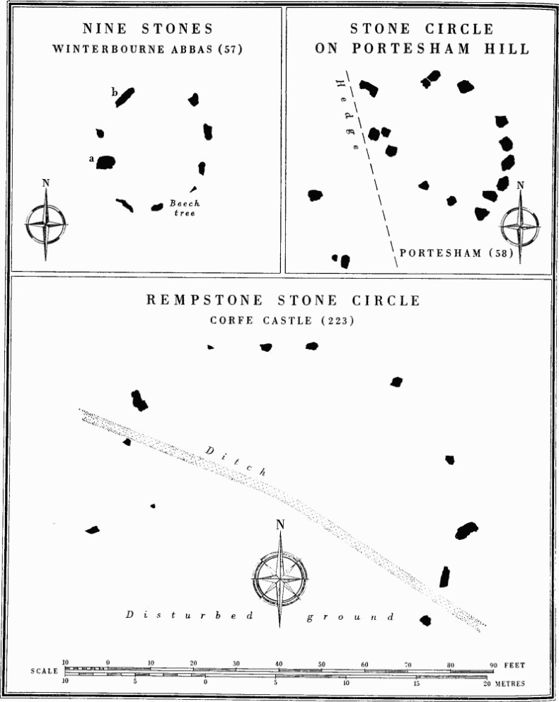
Multiple arrangements: the earliest are undoubtedly the circles, Winterbourne Abbas (57) and Corfe Castle (223), composed of well spaced standing stones. The first of these, the 'Nine Stones', is of particular interest since two of its stones, exceptionally massive compared with the other seven, can be paralleled by the Late Neolithic/Early Bronze Age 'A' and 'B' stones of the Kennet Avenue in the complex at Avebury, Wiltshire, and suggest both deliberate selection of such stones, and also a close link between the smallest and largest of stone arrangements. The Rempstone circle has a diameter three times that of the 'Nine Stones' and might have been connected with a possible avenue, now destroyed. Its low situation is akin to that of the 'Nine Stones' but its size resembles that of the circle in Kingston Russell (4) (Dorset I), which is probably of similar date but sited on high downland. Recent excavation has shown that the original circle on Portesham Hill, Portesham (58), was slightly smaller than the 'Nine Stones'. The Poxwell circle (12), likely to be of similar or rather later date, differs radically from the free-standing stone circles since there is little doubt that it was an integral part of a burial mound, now almost destroyed, and was originally a continuous stone wall. There is no pointer to the relationship between free-standing circles and barrows.
Big sarsens occur naturally in certain areas, e.g. the Valley of Stones (Ancient Field Group (3)), around Little Mayne, West Knighton (20), and in Portesham village (Arkell (1947), 241).
Affpuddle
(65) Dead Woman's Stone (SY 89 SW; 82209164), shown by O.S., cannot be traced in heathland now devastated by tanks.
Church Knowle
Boundary Stone, see Church Knowle (26), p. 47.
Corfe Castle
(223) Rempstone (fn. 1) Stone Circle (SY 98 SE; 99468207; Fig. p. 514), now incomplete, lies in a wood just S. of the Corfe Castle to Studland road at 278 ft. above O.D. on a gentle W.-facing slope near the foot of Nine Barrow Down. The wet site is cut by pools and ditches, owing largely to clay workings shown on a map of 1772 (in the possession of Major D. C. D. Ryder, Rempstone Hall).
The stones are irregularly-shaped boulders of hard gritstone from the local Bagshot Beds. Those surviving form an arc suggesting a circle originally about 80 ft. in diameter. Of the 12 on or near their original setting five still stand to heights varying from 2 ft. to 3¾ ft.; seven are prone and some of these have clearly been moved. The largest visible stone is 6½ ft. long, 2¾ ft. wide and 2 ft. out of the ground. Nine other stones are piled 80 ft. to the E.
The circle was first noted in 1908 and probably belongs to the Early Bronze Age (Dorset Procs. XXIX (1908), liii and Pl. facing liv; see also Antiquity XIII (1939), 148). In 1957 J. B. Calkin described two parallel rows of stones about 9 ft. apart ½ mile W. of the circle but aligned to a point some 12° N. of it. The stones, again of local sandstone, averaged 2½ ft. by 1 ft. by 6 ins. in size. It was suggested that they might have formed part of a processional way leading to the circle (Dorset Procs. LXXXI (1959), 114–6). The circle is No. 184 on the O.S. Map of Neolithic Wessex but early editions wrongly describe the Holdenhurst long barrow against this number.
Mere-stones, see Corfe Castle (177), p. 98.
Kimmeridge
Boundary Stone, see Kimmeridge (15), p. 135.
Knighton, West
Some 50 recumbent sarsens (SY 78 NW; 72148707, 72288717, 72388705) are scattered around Little Mayne Farm. They are a natural phenomenon and form no coherent plan, despite alleged arrangements in one or more circles or avenues (one of which is certainly a mediaeval road). Most have been moved. (R. Gale: notes made April 1728, printed in Surtees Soc. 11 (1883), 127; C. Warne, Illustrations of the History of Dorset (1847 MS. in D.C.M.), 232; Dorset Procs. xxx (1909), xlvi; Arkell (1947), 241; see also Knighton, West (20), p. 140.)
Portesham
The Hell Stone, see Long Barrows, Portesham (33).
(58) Stone Circle (SY 58 NE; 59628650), on Portesham Hill, stands 550 yds. S.E. of Hampton Barn on a level site about 680 ft. above O.D. (Fig. p. 514). Excavations in 1965, by Dr. G. J. Wainwright of the Ministry of Public Building and Works, established that the surviving stones were not bedded and that there had been an earlier circle. This circle, represented by the sockets of stones, lay under and to the W. of the field bank which crosses the site. It was 18 ft. to 20 ft. in internal diameter and was composed of nine stones, set in two arcs to N. and S.; the E. and W. sides were defined by narrow V-sectioned ditches. A hollowed track, running up to the circle on the N., was revetted on its W. side by small flat stones, and three stake-holes were found on the perimeter of the circle immediately to the W. A low bank of clay had been constructed between the track and the stones in the N.W. quarter and the S. edge of the socket on the E. side of the track was also built up with clay and stones. The circle had been disturbed before or by the building of the field bank with its side ditches. Stones have now been placed in the excavated holes. (Information from Dr. G. J. Wainwright; Dorset Procs. XXIX (1908), lxxviii (with photograph of later circle), 250; LXXXVIII (1966), 122–7; Antiquity XIII (1939), 142, fig. 2; O.S. Map of Neolithic Wessex, no. 143; R. D'O. Good, Weyland (1945), 32.)
(59) Stones (SY 58 NE; 59658688), two recumbent and partially buried sarsens, lie 5 yds. apart 350 yds. W. of Hampton Barn on top of Portesham Hill at 650 ft. above O.D. and on gentle slopes down to N. and E. They measure 10½ ft. by 4 ft. and 7½ ft. by 3 ft., the larger lying to the N. These two stones are probably the only remains of the 'collapsed dolmen' illustrated in Dorset Procs. XXIX (1908), lxxiv. The photograph, in which four or five stones are visible, suggests a collapsed chamber with a large tilted capstone. Crawford listed this as a long barrow orientated N.W. to S.E., with the two stones presumably as the remains of a chamber at the S.E. end, but there is now no evidence for this. Just to the N. is a probable round barrow, Portesham (44). (LVG I; O.S. Map of Neolithic Wessex, no. 144; G. E. Daniel, P.C.T.E.W. (1949), 235.)
(60) Stone (SY 68 NW; 61508664), irregular, of sarsen, stands 1600 yds. N.E. of Portesham Church. It is slab-like and about 3 ft. high with numerous shallow horizontal grooves, all but one apparently natural, on the N. face. The stone was probably erected in its present position in relatively recent times. Sarsens are natural in this area.
(61) Stone (SY 68 SW; 62758412), irregular, of limestone, stands in a hollow 220 yds. S. of East Shilvinghampton just N. of and slightly below the crest of an E. to W. ridge at about 230 ft. above O.D. It may mark the S. limit of shallow quarrying extending to E. and W.
Portland
Mere-stones, see Portland (95), p. 259.
Portesham (58) shown as before excavation in 1965 (see p. 513).
Poxwell
'Stone Circle', see Round Barrows, Poxwell (12).
Steeple
(27) The Harpstone (SY 98 SW; 92168058; Plate 217), monolith, of limestone, stands 1,180 yds. E.S.E. of St. Michael's Church, on the bank of a small stream and just inside the W. edge of Hurpston Coppice on ground falling gently N. to the Corfe River in the marshy valley bottom. It is 7¼ ft. high with a jagged and uneven top and has a maximum width of 3¾ ft. E.-W. and 3 ft. N.-S. The four faces are largely disfigured by vertical grooves and hollows, the result of weathering. Its origin is unknown. The place-name Herpston (1340) may refer to the stone, which stands on the bank between Herpston and Hyde manors and flanks the ancient road from Creech to Kimmeridge. (Hutchins I, 609; Fägersten, 136.)
Studland
Boundary Stones, see Studland (26), p. 282.
Swanage
Mere-stones, see Swanage (79), p. 287.
Turners Puddle
(25) Stone (SY 89 SW; 83749403) of sarsen, stands 1000 yds. N.E. of Holy Trinity Church on Black Hill and on the parish boundary with Bere Regis. It is 11 ft. high, 4 ft. in circumference and very much weathered.
Winterbourne Abbas
(56) The Broad Stone (SY 59 SE; 59549040; Plate 217), a large sarsen boulder, lies half-buried in the scarp falling from the S. verge of the Bridport Road 2530 yds. W. of Winterbourne Abbas Church. It is approximately 9 ft. long, 4 ft. wide and 2 ft. thick with the long axis E. to W. and a pointed E. end. All markings appear to be natural. (Hutchins II, 196.)
(57) The Nine Stones stone circle (SY 69 SW; 61079043; Fig. p. 514, Plate 211), stands immediately S. of the Bridport road 850 yds. W. of the church in an enclosure just inside Nine Stone Wood. The site is level at 345 ft. above O.D. on the S. edge of a narrow valley floor. The subsoil is apparently river gravel with Upper Chalk adjacent to the S.
The stones, all sarsens, are arranged in a rough circle with internal diameters of about 27½ ft. (N. to S.) and 23½ ft. (W. to E.). Though they are irregularly spaced, a gap to the N. is almost twice as wide as any other gap. Seven of the stones are small and low, from about 1 ft. to 2½ ft. high. Two are more massive: (a) is 7 ft. high and its elongated form recalls the 'A' stones in the Kennet Avenue near Avebury, Wilts.; (b), a large slab, 6 ft. high and 6 ft. across at the base, is like the 'B' stones in the same Avenue (cf. Antiquity x (1936), 420).
Aubrey recorded only nine stones, as did Hutchins in 1768; but Warne alleged traces of a tenth to the N.E., presumably in the wide gap. Stukeley's drawing of 1723 shows the circle in the same state as at present and nothing could be seen of any additional stone in 1936. (S. and C. M. Piggott, Antiquity XIII (1939), 146, with facsimile of Aubrey's MS. notes as pl. I; J. Hutchins, History of Dorset II, 196, and Gentleman's Magazine (1768), 112–3, letter signed J. H.; C. Warne, Ancient Dorset (1872), 117–8; J. Stukeley, Itinerarium Curiosum II (1724), tab. 92, which has been wrongly identified as showing a site in Winterbourne Monkton, Wilts.) The site is a guardianship monument of the Ministry of Public Building and Works and is No. 149 on the O.S. Map of Neolithic Wessex.
Winterbourne Steepleton
(65) Stones, possibly remains of chambered long barrow (SY 68 NW; 61408968; marked 'cromlech' on some maps; Plate 217), lie 1630 yds. W.S.W. of the church at 400 ft. above O.D. on a steep S.E.-facing slope, now in pasture. One large sarsen, an irregular oblong 8 ft. by 4¾ ft. and 1¼ ft. above ground, lies in the shoulder of a rounded scarp some 2 ft. high. A second sarsen, 4 ft. across and 1 ft. 8 ins. deep, projects from the scarp 5 ft. to the E. Three small boulders can be seen between these large stones. Warne listed this site among 'destroyed cromlechs' describing 'one large stone apparently the capstone with two or three others ... in a confused heap' (Ancient Dorset (1872), 136). The stones may not be in situ since the area was once part of the arable fields of Winterbourne Steepleton (Monument (12)), and the scarp is in part a lynchet ploughed down since enclosure. (LVG II; O.S. Map of Neolithic Wessex, no. 148.)