An Inventory of the Historical Monuments in Dorset, Volume 2, South east. Originally published by Her Majesty's Stationery Office, London, 1970.
This free content was digitised by double rekeying. All rights reserved.
'Roman Roads', in An Inventory of the Historical Monuments in Dorset, Volume 2, South east(London, 1970), British History Online https://www.british-history.ac.uk/rchme/dorset/vol2/pp528-531 [accessed 30 April 2025].
'Roman Roads', in An Inventory of the Historical Monuments in Dorset, Volume 2, South east(London, 1970), British History Online, accessed April 30, 2025, https://www.british-history.ac.uk/rchme/dorset/vol2/pp528-531.
"Roman Roads". An Inventory of the Historical Monuments in Dorset, Volume 2, South east. (London, 1970), British History Online. Web. 30 April 2025. https://www.british-history.ac.uk/rchme/dorset/vol2/pp528-531.
Roman Roads
Four Roman roads fall wholly or partly within the area of the present volume: the main road from London to Exeter via Badbury Rings and Dorchester, the roads from Dorchester to Ilchester and Radipole (Weymouth), and the road from Hamworthy (Poole) to Badbury. Descriptions of the first two, except where they approach Dorchester (see Approach Roads, p. 539), are reserved for treatment in Dorset V; the others are described here. (fn. 1)
Road I. Dorchester to Radipole, Weymouth (SY 68 NE, SE).
The road (Margary's no. 48) running S.W. from the S. exit of Dorchester has been recognized as Roman since the 17th century (Coker, 67); the only monumental remains are on Ridgeway Hill. The distance of six miles was covered in one minor alignment of 600 yds. to Maumbury Rings and perhaps two major alignments of almost equal length, laid out from the crest of Ridgeway Hill, to what would then have been a tidal creek at Radipole. Alternatively the route S. of Ridgeway Hill may have been in three alignments, following more nearly the line of the modern road through Broadwey.
The first alignment, represented by if not necessarily coinciding with Weymouth Avenue, is discussed below (see Dorchester, Approach Roads, 2). Thereafter from Maumbury Rings the elevated Weymouth road (A 354) is impressively straight and must be on the line almost to the summit of Ridgeway Hill where the present road bends southwards. Here the Roman agger continues the line for nearly 70 yds. to the crest; it was some 27 ft. wide and 3 ft. high above ditch bottom in 1953, but has been under plough. The W. side-ditch has probably been enlarged by erosion or use as a hollow-way, while the E. ditch is obliterated by a metalled track (SY 67078602; Bincombe parish). From the crest the new Roman alignment ran almost due S.; if the change was made in a curve the lane and the former parish boundary (fn. 2) may preserve the line, as they clearly do further downhill until it is lost in the old quarries. From Elwell the main road (A 354) follows the line as far as the corner of Stottingway Street.
The remainder of the route is uncertain. An unaltered alignment is perfectly feasible and would touch the known Roman site on Spa Hill (Weymouth (437)) before the final descent to Radipole Lake, but no positive remains are known although Hatcher's observations in 1802, recorded by Warne, seem to confirm it as far as Broadwey village. Alternatively the modern road diverging through Broadwey may indicate two Roman alignments, the second of which, followed in part by a former parish boundary as far as Redlands, would also touch the Spa Hill site. Roman burials at Broadwey (see Weymouth (443)) are doubtless associated with the road but cannot be said to favour either route decisively. Margary follows Codrington in suggesting that there was a final alignment from Redlands S.S.W. to reach the creek by the gentler incline, but the evidence is unsatisfactory. (Dorset Procs. LXXIII (1951), 97–9; I. D. Margary, Roman Roads in Britain (2nd edn. 1967), 112–13; T. Codrington, Roman Roads in Britain (revised edn. 1918), 256–7.)
Road II. Badbury Rings, Shapwick, to Hamworthy, Poole (ST 90 SE, SY 99 NE, SE, SZ 09 SW; Figs. pp. 529, 530).
The road (Margary's 4d) linked the settlement at Hamworthy, Poole, probably a port of the early conquest phase, with the Roman road from London to Exeter at a point N.E. of the Iron Age hill-fort of Badbury Rings. (fn. 3) The distance of nearly seven miles was covered in two major and three minor alignments, of which the first was a direct continuation of the line of the London road for some 400 yds. beyond the latter's branch S.W. towards Dorchester. The London road has thus been plausibly claimed as laid out in the first instance to pass E. of the Rings to Hamworthy, with the Dorchester line as a subsequent although doubtless very early development. (fn. 4) Another road (Margary's 46) ran N.N.W. towards Bath from the bend or angle made by Road II outside the E. ramparts of Badbury in turning S.E. towards Poole Harbour.
A road from Winchester via Nursling and the New Forest (Margary's 422) seems to have joined Road II somewhere S.W. of Wimborne. Warne's and Wake Smart's claim to detect the beginning of a branch from Corfe Hills towards Christchurch is not substantiated.
The road is now accurately marked on the O.S. maps throughout most of its course, but its termination in the Hamworthy peninsula, where it may have thrown off a branch touching the known settlement (Poole (402)) on the S. shore of Holes Bay, is uncertain. Aerial photographs give the clearest indication of the junctions at Badbury and of the route in the N. sector, but an agger remains in several places between Lodge Farm, N. of Kingston Lacy, and the Stour backwater at Lake, perhaps the original main stream, (fn. 5) and is exceptionally fine in lengths on Barrow Hill and Corfe Hills, S. of the by-road between Sleight and Merley, where part of it is scheduled as an ancient monument. Where best preserved in this sector the agger is nearly 3 ft. high and 25 ft. wide, between side-ditches 82 ft. or more apart, but elsewhere spreads up to about 45 ft. wide. It has been fully sectioned only behind Aimer Road on Ham Common, but the road metal appears to have been of local gravels and, in the Hamworthy peninsula, of beach shingle.
The route was undoubtedly an early one; in addition to the Claudian occupation at Hamworthy, a pottery kiln of like date probably serving military needs is known by the road at East End (Corfe Mullen (24)), and a camp or stores base adjacent to it is currently under investigation a half mile beyond in the Stour valley at Lake Farm. (fn. 6). The constructional details, however, need not be those of the original road.
Badbury Rings to Eye Mead, Pamphill (alignments 1 and 2). The agger of the London-Exeter road branches S.W. from the Harley Down-King Down alignment about 370 yds. beyond King Down Farm, Pamphill, but although no ridge remains it is clear that Road II, partly under the modern lane, continues without deflection (alignment 1) to the Shapwick parish boundary. (fn. 7) Immediately beyond the hedge a turn S.E. into alignment 2 is masked by a spinney, although the curving agger shown on O.S. maps since 1887 is now, at least, no more than a slight scarp falling eastwards; a road towards Bath strikes off N.N.W. from the curve. Some trace of the agger of Road II is discernible immediately beyond the bend where turf-stripping in 1953 uncovered small Tertiary pebbles, presumably metalling rather than exposed cap; a width of 84 ft. centre to centre between side-ditches was indicated when the field beyond the parish boundary was under plough (Dorset Procs. LXXXV (1963), 106).
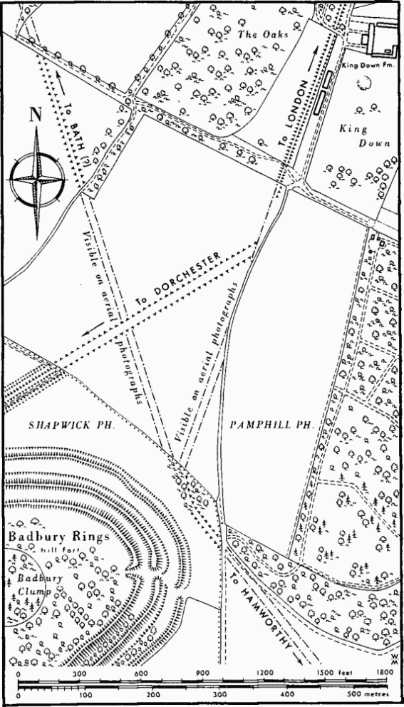
Road II. Road Junctions Near Badbury Rings
Remains of the agger by Lodge Farm, on Upper Chalk, are now negligible but 170 yds. are preserved in fair state through Abbott Street Copse as far as the lane; there are no appreciable remains in Grove Wood nor alongside the earthwork (fn. 8) at Cowgrove where it was formerly traced. Beyond Cowgrove Road the line crosses Valley Gravel presumably to a bridge across what is now the main stream of the Stour, midway between Eye Bridge Ford and Old Ford, and reappears intermittently as a distinct agger dead on course across the alluvial flats of Eye Mead. Its condition there implies that, beside the river, the agger has been destroyed rather than buried below silt; the clearest exposure (the N. bank) shows no trace of the road in section nor of approaches to a ford. The agger in Eye Mead is interrupted by old flood channels but is almost continuous for some 370 yds. as it nears the Stour backwater; at best it is 30 ft. wide with crest I ft. above the alluvium.
Lake Farm to Ham Common, Poole (alignments 3 and 4). Near Lake Farm the road swung S.S.W. as the low terrace of Valley Gravel was reached some 45 yds. beyond the backwater; the bend and general direction established by Smith (op. cit. below, 1943), in a number of test holes of which details are unknown, has been further defined (i) in an exposure of gravel (SY 99809910) in 1962 in a drainage trench dug along the N. side of the main road (A 31); (ii) by the location of the E. ditch in 1966 at 99709903 immediately E. of the former railway crossing where the road enters the parish of Corfe Mullen. (fn. 9) (Information from Mr. N. H. Field.)
A low ridge, spreading to about 80 ft. wide and clearly marked for some 460 yds. in the arable fields beside the former railway to E., seems to head straight for the bend made by Road II at the backwater (see Fig.; R.A.F. V.A.P. CPE/UK 1934: 5192). It coincides with a former field boundary (Tithe Map, Great Canford, 1843) but may be part of a road identified as Roman by C. D. Drew near Park Farm, Colehill (SZ 02679948 to 03529984) and thought to come from the New Forest (Margary's 422; Somerset and Dorset Notes and Queries XIX (1927–9), 170–1; H. P. Smith, op. cit. 1948, 85–7); excavations on both sides of the cattle-way crossing the old railway to Lake Farm have, however, failed to reveal convincing traces of road metal or side-ditches, while a direct prolongation E. involves difficulties with the course of the Stour S. of Wimborne (Dorset Procs. LXXXVII (1965), 99–101).
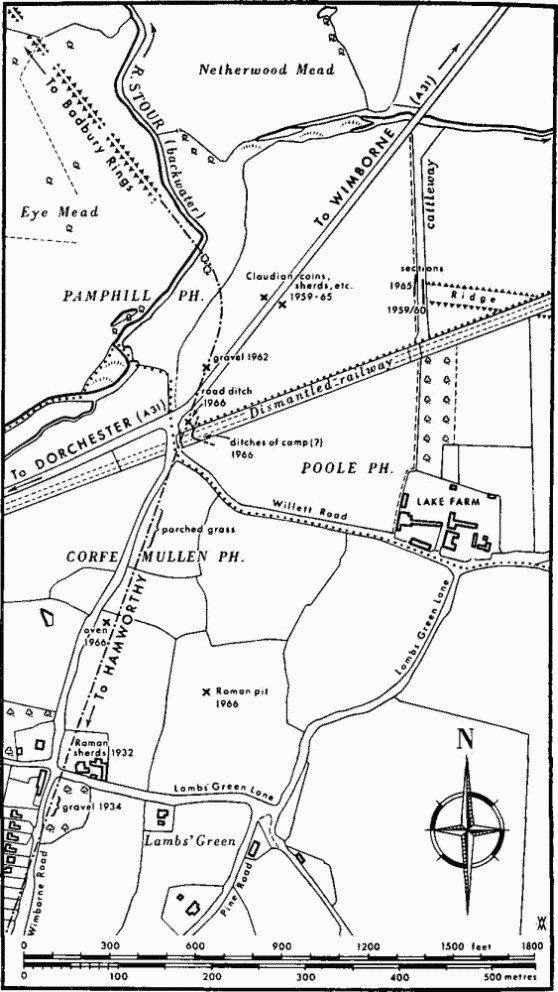
Road II. Alignments 2 and 3 Near Lake Farm
Smith's observations may be accepted for the course of Road II for 750 yds. beyond the old railway; they imply a substantially straight alignment of half a mile between the Lake Farm bend and the crest of the Plateau Gravel at East End, (fn. 10) where the road's second major alignment begins its course almost due S. to Ham Common. There are few traces of the new line until Barrow Hill is reached, except at the foot of Happy Bottom, in which the agger, where least disturbed, is 45 ft. wide and 2½ ft. high but has no visible ditches; such traces as exist of a much wider agger affirmed by Smith seem due to splay as the ridge runs into the N. slope. From Higher Merley Lane an old heathland road formerly known as Old Bound Lane follows the line across Bagshot Beds and Plateau Gravel for 2½ miles with the parish boundary on its W. margin; the lane is now viable mainly as a cart track or bridle path which crosses and recrosses the agger or follows its crest. Substantial lengths of the Roman road, in places up to 3 ft. high and 25 ft. wide, remain on Barrow Hill and Corfe Hills above the 200 ft. contour; the finest sectors are 300 yds. N. and 500 yds. S. of Rushcombe Bottom, where shallow sideditches, over 6 ft. wide and between 82 ft. and 85 ft. apart, centre to centre, fall outside the bounds of the lane. Thereafter remains are negligible between the houses and gardens of Broadstone and past Upton Heath, but suggest that the crest of the agger lay generally towards the E. margin of the lane; W. of Ty-coed Cottages the agger survives for 70 yds. as a broad low ridge altogether E. of the lane. A coin of Commodus (A.D. 180–192) was found nearby in 1942. At Broadstone, Codrington noted a section in a gravel-pit (SY 99319595) where 1½ ft. of gravel metalling, 18 ft. wide at base, overlay the old heath soil. At Ty-coed the lane diverges at last, but the parish boundary continues straight into the grounds of Upton House; there are no traces of the road, but beyond the railway a ridge, 40 ft. wide and 2½ ft. high W. of Vineyard Copse (formerly a parish boundary), shows that the line was maintained across the main road (Blandford Road, A 350) to the verge of Ham Common.
Ham Common to Hamworthy (alignment 5). The remainder of the route has been accurately traced by Smith, who sectioned the agger, on Bagshot Sands, by the cottages in Almer Road where it is still plain (SY 99049144; Smith, op. cit., 1932). The metalling consisted of sandy gravel on beach shingle, over 26 ft. wide and 1½ ft. thick, on a 4 in. bedding of clayey sand laid on cut heath vegetation. A ditch was found on the W., 16 ft. from the centre of the ridge.
At the edge of the common, (fn. 11) on Plateau Gravel, the line swings S.E. from the local crest into the final or last known alignment, (fn. 12) crossing Lake Road and passing S. of St. Michael's Church near which Roman remains are said to have been found (see Poole, p. 603). It recrosses the main road E. of the Rectory (99429101) (fn. 13) and passes immediately in front of the new school, where gravel, mainly beach shingle, was noted in 1947 up to 1 ft. thick. Some of the surface signs recorded by Smith in this sector have now disappeared, but 10 ins. of beach shingle metalling were found behind the house renumbered 134 Blandford Road (99979048). The last indications on this alignment were at the houses renumbered 128 and 126, and reputedly under the Coronation Room (SZ 00079038) which is about 150 yds. W.S.W. of the occupation site on Holes Bay (see Poole (402)). Smith considered that the road would have terminated in a more easterly alignment bringing it to the deep water of the Holes Bay channel, and suggested that this was the function of a supposed branch road, over early 'huts', located along the S. side of the known settlement area at Carter's Tile Works from 00229039 to 00269037 (Dorset Procs. LII (1930), 102, fig. 5); 10 ins. of compact shingle metalling contained fragments of amphora and samian ware.
(H. P. Smith, Dorset Procs. LIV (1932), 5–14, LXV (1943), 53–9, History of Poole I (1948), 78–85; I. D. Margary, Roman Roads in Britain (2nd edn. 1967), 105–6; T. Codrington, Roman Roads in Britain (revised edn. 1918), 253–4; T. W. Wake Smart, Dorset Procs. xi (1890), 20–5; C. Warne, Ancient Dorset (1872), 180–3; Hutchins (1st edn. 1774), I, xiv, 2; R. C. Hoare, Ancient Wiltshire, II (1821), Roman Aera 34–5. Aerial photographs: R.A.F. V.A.P. CPE/UK 1893: 3096–7; CPE/UK 1934: 5192–3; J. K. S. St. Joseph O.A.P. UL 2, UL 9, LL 24.)
Sir Ian retained his belief in the priority in date, however slight, of the road towards Bath over that to Dorchester; the former's association with the Hamworthy road, and the interruption of its ditches by those of the Dorchester road, apparent in the aerial photographs by Dr. St. Joseph, seem to confirm this, but factors indicating the remaking of the main S.W. road near Bokerly Dyke in Cranborne Chase (cf. Arch. J. CXVIII (1961), 75) warn us that these ditches at Badbury and the great agger between them need not be early features.