An Inventory of the Historical Monuments in Dorset, Volume 3, Central. Originally published by Her Majesty's Stationery Office, London, 1970.
This free content was digitised by double rekeying. All rights reserved.
'Alton Pancras', in An Inventory of the Historical Monuments in Dorset, Volume 3, Central( London, 1970), British History Online https://www.british-history.ac.uk/rchme/dorset/vol3/pp1-4 [accessed 27 July 2024].
'Alton Pancras', in An Inventory of the Historical Monuments in Dorset, Volume 3, Central( London, 1970), British History Online, accessed July 27, 2024, https://www.british-history.ac.uk/rchme/dorset/vol3/pp1-4.
"Alton Pancras". An Inventory of the Historical Monuments in Dorset, Volume 3, Central. (London, 1970), , British History Online. Web. 27 July 2024. https://www.british-history.ac.uk/rchme/dorset/vol3/pp1-4.
In this section
AN INVENTORY OF THE ANCIENT AND HISTORICAL MONUMENTS IN CENTRAL DORSET
Arranged by Parishes
The group of four figures immediately following the heading of each parish is the National Grid reference to the parish church, permitting easy location of the place on the one-inch Ordnance Survey Map at the end of the volume. The next line indicates the sheets of the six-inch O.S. (edition of 1960) covering the parish. Monuments generally are located by six or eight-figure grid references and by orientation and distance from another monument, usually the parish church.
In general, earthwork plans are given at a scale of 25 inches to one mile, but the smallest sites are shown on a larger scale and some of the biggest sites, notably the hill-forts, have been reduced to a smaller scale to avoid large folding pages. Maps of 'Celtic' fields are given at 6 inches to one mile.
Architectural plans have auni form scale of 24 ft. to the inch, except small key plans which are scaled at 48 ft. to the inch. Dimensions given in the Inventory are internal unless otherwise stated. The date given in the description of a memorial is that of the death of the person commemorated; if known the date of erection is added. Surnames in round brackets are maiden names; data enclosed in square brackets are derived from literary sources, usually Hutchins. Numbers following unidentified shields-of-arms refer to their blazons, listed on p. 346.
'Celtic' Field Groups are described extra-parochially in a separate section (see p. 318) and Roman roads will be dealt with as a whole in Dorset V; these exceptions apart, the monuments of Central Dorset are listed under the names of the fifty-eight civil parishes in which they occur.
1 ALTON PANCRAS (6902)
(O.S. 6 ins. ST 60 SE, ST 70 SW)
Alton Pancras is an irregularly shaped parish of 2,280 acres at the head of the valley of the R. Piddle and at the top of the main Chalk escarpment; the land is almost entirely Chalk and falls from altitudes over 800 ft. above sea-level in the N.E. and N.W. to about 350 ft. at the point where the river crosses the S. boundary. Several deeply cut dry valleys drain from E. and W. into the main valley. Over the escarpment, a N.E. extension of the parish lies on Greensand, Gault and Kimmeridge Clay at an altitude of about 450 ft. The village is now scattered for nearly ¾ m. along the Piddle valley but it appears originally to have been two separate settlements, Barcombe and Alton, each with its own mediaeval open field system. (fn. 1)
Ecclesiastical
(1) The Parish Church of St. Pancras was rebuilt in 1875 except for the West Tower which is of the 15th century. A little tracery in the W. window of the S. wall of the nave may also be of the 15th century; it is a three-light opening with cinquefoil cusping under pierced spandrels in a square head. Hutchins (IV, 461) records 12th-century mouldings on the chancel arch and over the N. and S. doorways, but nothing of that date is seen today, apart from some dubious chevron ornament reset over the N. doorway.
Architectural Description—The Tower (9 ft. square) is of flint and rubble, with rubble bonding courses and ashlar quoins and dressings. It has two external stages divided by a weathered string-course. The embattled parapet has crocketed corner finials which were restored in the 19th century. The two-centred tower arch has casement mouldings on the E. and W. sides and continuous jambs. The restored W. doorway has a moulded two-centred head, continuous jambs and a moulded label; the internal lintel is a reused late 13th-century coffin-lid with a double hollow-chamfered border, decorated on the upper surface with a floriate cross. The restored 15th-century W. window has a casement-moulded two-centred head and continuous jambs, with three trefoil-headed lights with vertical tracery. Just above the string-course the N. wall has a small rectangular window. Above, the E., W. and S. sides of the tower have belfry windows of two square-headed lights with chamfered surrounds; the N. window is of two trefoil-headed lights. The belfry windows are closed by stone slabs with quartrefoil perforations.
Fittings—Bells: four; treble, dated 1596, probably by William Warre; 2nd, perhaps late 15th century and from Salisbury foundry, inscribed 'Maria' in black-letter; 3rd, 14th century, inscribed 'ave grcia (sic) plena' in Lombardic letters; 4th, with vine-scroll fillet below dome and foliate crosses as stops between initials, with date 1664; bell-frame carved with dates 1761, 1818, 1842. Coffin Lid: In W. tower, reset above W. doorway, with double hollow-chamfered edge and traces of floriate cross, 13th century. Coffin Stools: Pair, with turned legs, 18th century. Communion Table: In vestry, 3½ ft. by 2 ft., with turned legs, 18th century. Font: Octagonal stone bowl with quatrefoil panels, pedestal and underside of bowl with recessed round-headed panels, moulded base; late 15th or early 16th century. Monument and Floor-slabs. Monument: In churchyard, S. of nave, of Mary Barle, 1715, headstone with cherub and scroll-work. Floor-slabs: In chancel, under communion table, (1) of Thomas Haskett, 1744, Purbeck marble slab with arms; in middle of chancel, (2) of John Haskett, 1730, Purbeck marble slab. In tower, (3) of Edwin Tomkins, 17 . ., trimmed and partly defaced slab with arms; adjacent, (4) of Giles Tomkins, apothecary, 1784, fragmentary and worn. Weather-vane: On W. Tower, with scrolled wrought iron standard and hollow copper cock; 19th century.
Secular
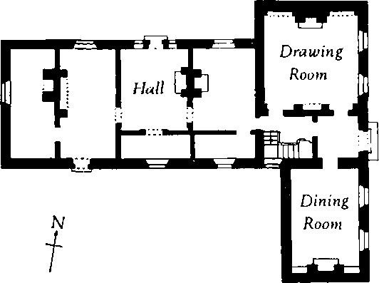
(2) Manor House (69940238), 20 yds. S.E. of (1), is of two storeys; the walls are of brick in Flemish bond with stone dressings and the roofs are slate-covered. The plan is T-shaped and the principal rooms are in the cross-wing, facing E. According to Hutchins (IV, 460) the house was remodelled by Thomas Haskett (d. 1744), who inherited it from his uncle John Haskett (d. 1730), an eminent Salisbury apothecary. Further improvements were made in the decoration of the interior c. 1760 and the Gothic details of this date in the Drawing Room are examples of a style that is not common in Dorset.
Manor House
The E. front is symmetrical; it has an ashlar plinth, a platband at first-floor level, rusticated quoins and a moulded eaves-cornice; plat-band and cornice are mitred around the quoins. The doorway in the centre has a moulded stone surround with a pedimented cornice supported on brackets, and the sashed window above has a stone architrave with sidescrolls and a key-block; the other eight sashed windows have flat gauged brick heads with key-stones, rubbed brick jambs, plain stone sills and shaped aprons. The ends of the cross-wing are gabled; the N. end contains a blocked round-headed opening and the S. end is hung with mathematical tiles. The W. wing contains a number of original windows, two with round heads and radiating glazing-bars in the upper sashes.
Inside, the Drawing Room has fielded panelling in two heights and a cornice with dentils. The fireplace surround has Tuscan columns and a Doric entablature with a central panel of grapes and foliage. Recesses on each side have Gothic ogee heads decorated with foliate arabesques; a third recess facing the fireplace is flanked by Tuscan pilasters. The Dining Room is similarly panelled and has a fireplace surround with Ionic pilasters and an entablature with a carved panel. Two vestibules between the Drawing and Dining Rooms are also panelled; that to the E. is entered through the central doorway of the E. front while the other contains the stairs, with turned newel posts and balusters and a moulded handrail. In the W. hall are three 18th-century doorcases with richly carved and moulded architraves; two are surmounted by foliate friezes with carved cornices. The doors have fielded and beaded panels with enriched mouldings.
The Stables to the S. are of the second half of the 18th century. Half-way between the house and the stables stands the Brewhouse, a single-storied brick building of the late 18th or early 19th century containing coppers and a fireplace; a Pigeon-cote adjoins it to the S. To the W., another brick-built outhouse has a stone doorway with an elliptical head; this leads to a vaulted, partly underground chamber, perhaps an Icehouse. The road to the church and manor house passes between a pair of rusticated stone Gate Piers with moulded cornices surmounted by gadrooned urns with foliate finials (Plate 66). The inner face of each pier has a projecting stone check with a scroll finial; on the outside of each pier a larger scroll forms the capping of the adjacent brick wall, which sweeps up to meet it.
(3) Austral Farm, 50 yds. N.E. of the church, is of two storeys with attics. The walls are rendered and the roofs are slate-covered. The farmhouse was built in the 18th century and contains a staircase with fluted newel posts, turned balusters and a moulded handrail terminating in a scrolled knob with leaf enrichment.
Monuments (4–12)
Unless otherwise described the following monuments are of the 18th century and of two storeys, with cob walls, thatched roofs, brick chimneys and casement windows.
(4) Cottages, four, dispersed, three on the E. side of the main road 250 to 300 yds. S.E. of the church, and one facing them across the Piddle brook. The most southerly of the three was originally a pair of cottages; the others are single dwellings, each of two bays with a central doorway. The fireplaces are in the end walls.
(5) Post Office (70040235), 130 yds. E. of (2), is of banded brick and flint; the symmetrical three-bay S. front is dated 1826 on a panel over the central doorway.
(6) Cottage, 30 yds. N. of the foregoing, is of one storey with dormer-windowed attics.
(7) Cottages, row of three (69950270).
(8) Farmhouse (69930285) is in two parts; the W. part has walls of rendered brick and rubble and may be of the 17th century; the E. part is brick and probably of the 19th century. The older part contains a plank-and-muntin partition. An adjacent Barn of brick and thatch is of c. 1800.
(9) Cottage (69900286) has a symmetrical three-bay S. front and chimneys in the gabled end walls.
(10) Cottage (69960309).
(11) Cottage (69950314) has been rebuilt at the S. end in flint with occasional brick courses; it has stop-chamfered ceiling beams and may be of the late 17th century.
(12) Narn Barn (68980360), perhaps of the 17th century, has walls of flint with rubble dressings and an iron roof; the long axis lies E. to W. and the doorways are in projecting bays to N. and S.
Early 19th-century buildings include 'Beechmead', formerly the Vicarage (69820279), and Alton Mill (70230136). The latter, a water-mill on the R. Piddle, has rendered walls of brick and rubble and a slated roof.
Mediaeval and Later Earthworks
(13) Settlement Remains (69950255), formerly part of Alton village, lie around Croker's Barton. They include some well-preserved closes bounded by low banks and scarps up to 2 ft. high, and other more disturbed remains.
(14) Settlement Remains (700032), part of the hamlet of Barcombe, lie N. of Barcombe Farm. Within an area of 4 acres are a number of small closes and platforms bounded on the N.E. and E. by a bank 16 ft. wide and up to 2 ft. high, with an outer ditch 10 ft. wide.
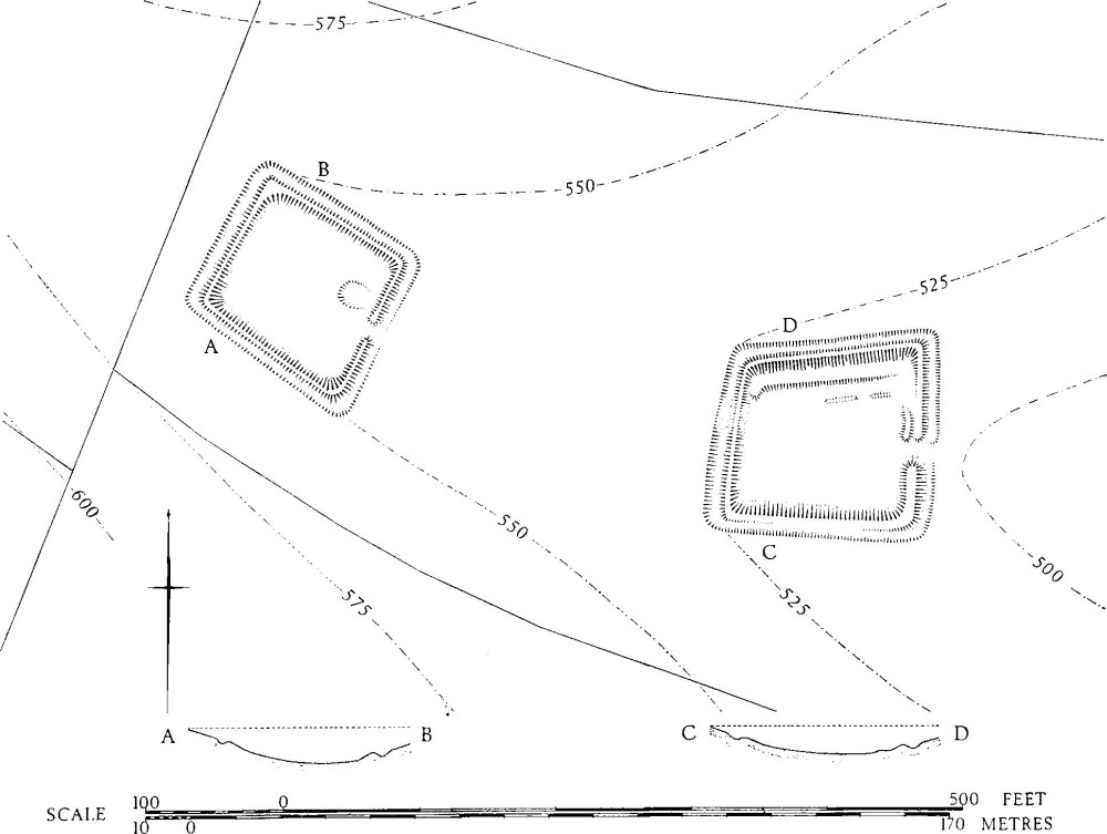
(15) Cultivation Remains. The open fields of Alton Pancras still existed in 1724 (Survey of Manors of Alton Pancras, 1724, D.C.R.O.) but were all enclosed by 1741 (Court Book of Alton Pancras, 1741–1865, D.C.R.O.), presumably by agreement as there is no Parliamentary Act of Enclosure. Remains exist in three places. To the W. of the village, on both sides of Rake Bottom (around 690022), are some 45 acres of strip lynchets arranged in end-on and interlocking furlongs; on the W. these run into 'Celtic' fields (Group (38), p. 326). E. of the village in Burnt House Bottom (702025) are three interlocked furlongs of contour and cross-contour lynchets covering some 20 acres; immediately to the S.E. strip ploughing has modified other 'Celtic' fields. In the extreme E. of the parish running N.W.S.E. across Watcombe Bottom (713030) is a massive riser, up to 15 ft. high, which perhaps represents former strip cultivation. There are other strip fields immediately to the N.W. on Watcombe Plain, where they overlie 'Celtic' fields (Group (42), p. 327).
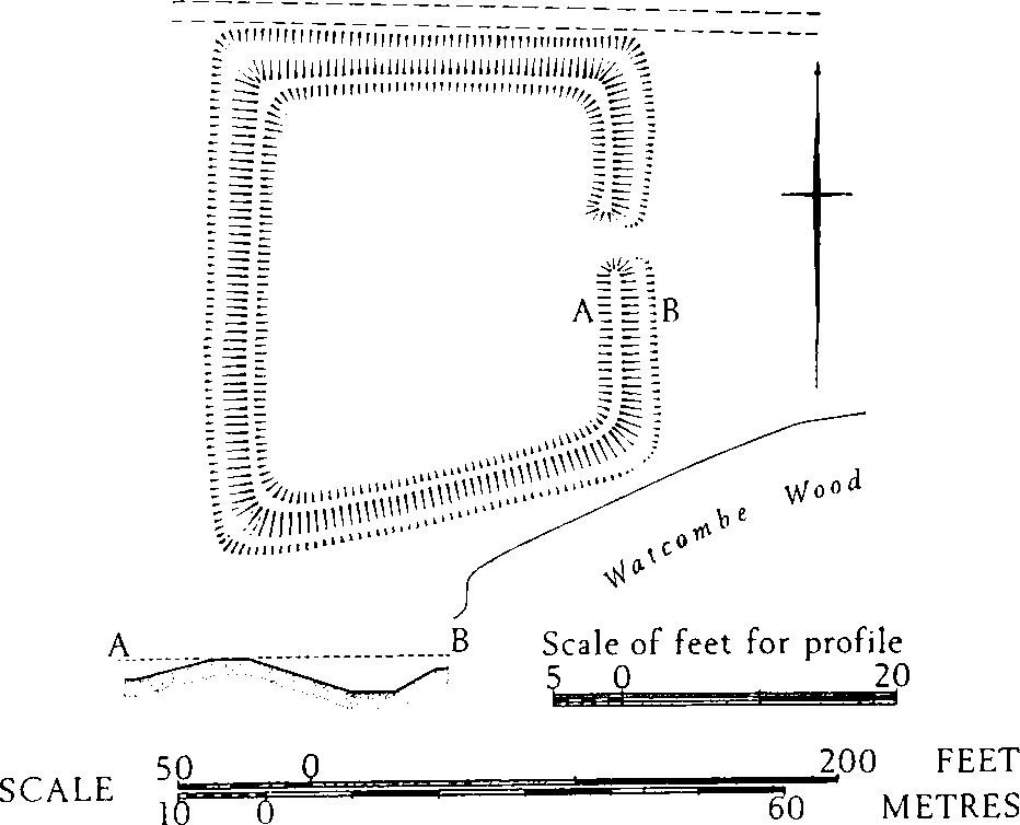
Alton Pancras. (18) Rectangular Enclosures in Tenant's Bottom
Nothing is known of the date of enclosure of the open fields of Barcombe but remains are found in a few places. E. of Barcombe Farm (705031) are slight remains of contour strip lynchets, and on the S. side of Church Hill (704034) strip fields have modified 'Celtic' fields (Group (41), p. 327). In and around Holcombe Bottom are extensive remains of contour and crosscontour strip lynchets, and ridge-and-furrow (e.g. 694032, 694035, and 687034). To the W. strip lynchets run into 'Celtic' fields (Group (39), p. 326).
Roman and Prehistoric
Possible Settlement, see 'Celtic' Field Group (42).
'Celtic' Fields, see pp. 325f., Groups (38), (39), (41) and (42).
Monuments (16–17) Round Barrows
(16) Bowl (70360355) on Church Hill on a gentle S. slope at 660 ft. O.D.; centre of mound disturbed; diam. 35 ft., ht. 2 ft.
(17) Bowl (70620250) on West Hill at about 690 ft. O.D., covered with thick scrub; diam. about 36 ft., ht. 3½ ft.
Undated
(18) Rectangular Enclosures, two, lie close together in Tenant's Bottom, spanning the floor of a dry valley in the Chalk (see plan on p. 3). Both are undated but are perhaps mediaeval, as they appear to be later than the surrounding 'Celtic' fields (Group 38). The more westerly of the two enclosures (69210155) covers about 1/5 acre and is bounded by a bank 2 ft. high, with an outer ditch, 1½ ft. deep. There is an entrance 8 ft. wide at the centre of the S.E. side. The interior is featureless except for a slightly irregular hollow, 1½ ft. deep, near the entrance. The other enclosure (69340152), 70 yds. E. of the first, is approximately ¼ acre in area and is bounded by a bank and outer ditch as before, and has a comparable entrance on the E. On the inside, immediately N. of the entrance, a length of bank runs N. at first and then curves W.; this is more likely to be the remains of a structure than an inner bank of the enclosure, as has been suggested (Dorset Procs. XXXIII (1912), 42). On the N. side between this bank and the enclosure bank is a broad terrace 1 ft. high.
(19) Enclosure (71560358) lies on Church Hill at about 760 ft. O.D. It consists of a rhomboidal area of approximately 2/5 acre bounded by a bank 1½ ft. high with an external ditch 1 ft. deep. There is an entrance 15 ft. wide in the centre of the E. side. The interior is featureless.