An Inventory of the Historical Monuments in Dorset, Volume 3, Central. Originally published by Her Majesty's Stationery Office, London, 1970.
This free content was digitised by double rekeying. All rights reserved.
'Stoke Wake', in An Inventory of the Historical Monuments in Dorset, Volume 3, Central(London, 1970), British History Online https://www.british-history.ac.uk/rchme/dorset/vol3/pp257-259 [accessed 30 April 2025].
'Stoke Wake', in An Inventory of the Historical Monuments in Dorset, Volume 3, Central(London, 1970), British History Online, accessed April 30, 2025, https://www.british-history.ac.uk/rchme/dorset/vol3/pp257-259.
"Stoke Wake". An Inventory of the Historical Monuments in Dorset, Volume 3, Central. (London, 1970), British History Online. Web. 30 April 2025. https://www.british-history.ac.uk/rchme/dorset/vol3/pp257-259.
In this section
45 STOKE WAKE (7606)
(O.S. 6 ins. ST 70 NE)
The parish, covering 1,087 acres, lies on the N.W. slope of Bulbarrow Hill, a residual spur of the Chalk escarpment. A protuberance at the S.E. corner includes the ridge of the hill, 850 ft. above sea-level, and extends over part of the southern slope. Northwards from the ridge the land falls sharply to 500 ft., at which point outcrops of Greensand occur. Further N. and N.W. the greater part of the parish undulates between 400 ft. and 300 ft. on Gault and Kimmeridge Clay. The land is drained by a small tributary of the R. Divelish in the N., and by a tributary of the R. Lydden which forms the western boundary of the parish. Stoke Wake is a Domesday vill (f. 78b), with a recorded population of 15. Much of the land remained unenclosed meadow and common until about the middle of the 19th century. (fn. 1) The N. half of Rawlsbury Camp, a small, strongly defended Iron Age hill-fort, set high on the Chalk escarpment, lies inside the parish and is the most important monument.
Ecclesiastical
(1) The Parish Church of All Saints was rebuilt in 1872.
Fittings—Font: (Plate 26), of limestone, with octagonal bowl, splayed below, on octagonal stem, hollow-chamfered plinth and chamfered base; facets of bowl with quatrefoil panels alternately enclosing roses and shields, splays with coupled trefoil-headed panels, stem with roll-moulding and single trefoil-headed panels; 15th century. Cover, of oak, octagonal pyramid with ball finial; late 17th century. Plate: includes silver cup and cover-paten of Elizabethan type, cup with band of engraved strapwork, hallmarks of 1633 and maker's initials I.G.
Secular
(2) The Manor House (76450641), 40 yds. S. of the church, is two-storied and has walls of rubble and brick with ashlar dressings, other walls rendered, and tiled roofs with stone-slate verges. The E. range was built early in the 18th century and the S. wing is of the 19th century.
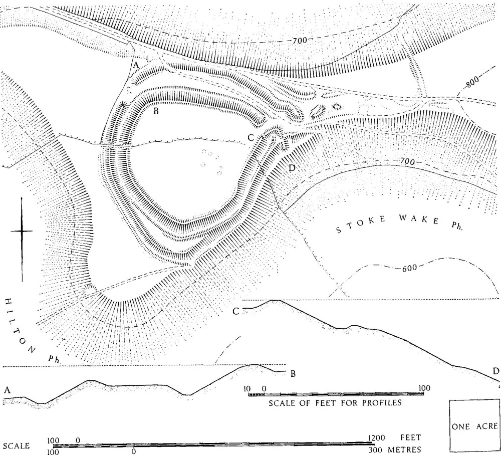
Stoke Wake. (6) Rawlsbury Camp. Iron Age Hill-fort
The 18th-century N. front is of five bays with a moulded plinth, an ashlar plat-band above the ground-floor windows, and ashlar quoins; the E. bay is wider than the others. The lower storey, is of rubble and the upper storey is of brickwork in English bond. The doorway, in the centre bay of the lower storey, is of ashlar with a moulded and eared architrave, a keystone and an enriched entablature with a broken segmental pediment; the plinth moulding is mitred downwards on each side of the doorway. The ground-floor windows are of stone, and of four square-headed lights, except the one immediately E. of the doorway, which has five lights; the mullions are hollow-chamfered within chamfered surrounds. The first-floor windows correspond with those below but are of timber; the window above the doorway is of three lights. The gabled E. wall is of coursed rubble, with a projecting chimney-breast, weathered at the top in brickwork. The S. front is partly masked by the later S. wing but the exposed part has a plat-band as on the N. front, and is of rubble in the lower storey and of brick above.
(3) Cottage (76120662), ¼ m. N.W. of (1), is single-storied with attics, and has walls of rubble and brick and a thatched roof. It was built in the 18th century and contains chamfered beams and an open fireplace. (Destroyed by fire 1963).
(4) Ridout's Farm (75480648), house, 5/8 m. W. of (1), is single-storied with attics, and has rubble walls and thatched roofs. It dates from the late 17th or early 18th century but it was repaired, altered and extended in the 18th and 19th centuries; the original building had a half-H plan. One window has hollow-chamfered timber mullions, the other openings have modern surrounds. Inside, the ground-floor rooms have stop-chamfered beams.
Mediaeval and Later Earthworks
(5) Cultivation Remains. A three-field system appears to have been in existence in the early 14th century (P.R.O., Assize Roll No. 1349/m. 4d) but the date of enclosure is unknown. About 600 yds. S.W. of (1), on the S.W. slope of Bulbarrow Hill (760059), are the remains of at least 26 flat strips, lying across the contours; they are up to 300 yds. long, 17 yds. to 50 yds. wide and are bounded by low banks. Immediately to the E. (764058) are two fragmentary contour strip lynchets.
Roman and Prehistoric
(6) Rawlsbury Camp (768058), an Iron Age bivallate hill-fort (Plate 199), is prominently sited at 780 ft. above O.D., on a spur extending W. from the S.W.-N.E. alignment of the Chalk escarpment. The S. half of the camp lies in Hilton parish. The ground falls steeply away on the N. and S.E. and less steeply on the W.; to the E. it rises along a narrow neck towards the summit of Bulbarrow Hill. The defences enclose a pear-shaped area of 4 acres with an entrance at the narrow E. end.
The defences comprise two banks, each with a ditch, adjoining on the W. and S.E. but separated by a berm 40 ft. to 70 ft. across on the N. and S. The inner rampart stands up to 5 ft. above the interior and up to 19 ft. above the ditch bottom. The ditch varies in depth from a mere shelf on the S.E. to 8 ft. on the N., and in width from 15 ft. to 30 ft. Traces of a counterscarp bank are visible on the S., and on either side of the entrance. The outer rampart is more variable and along the N. side it has been damaged by tracks and by the present road; on the inside it rises up to 4 ft. above the berm and on the outside its height varies between 14 ft. on the N.W. and 22 ft. on the S.E. The outer ditch has been partly destroyed on the N., and on the S.E. it is no more than a narrow sloping shelf, but where best preserved it is 25 ft. across and 4 ft. deep. The ramparts appear to represent two constructional phases, the inner rampart probably being an addition to an original univallate fort. The elaborate entrance, much disturbed by tracks and by digging, consists of a gap through the inner rampart, flanked by the out-turned ends of the bank which, on the S., turns and crosses the line of the outer bank. The entrance is protected by a barbican or outwork formed by the outer rampart, but the precise form is difficult to determine because of disturbance. Within the camp, the S. half contains slight depressions, probably the remains of occupation. Sherds found in trenches dug during army manoeuvres in 1951, in the rearward slope of the inner rampart, include wares that are possibly Iron Age 'A' and 'C', or later (Dorset Procs., LXXVI (1954), 94). Cross-dykes E. of the fort may well be related to it (see below, and Woolland (7)–(9)).
(7) Cross-dyke (77000598–77030586) runs almost N.-S., up the N. face and across the narrowest part of the spur at the W. end of Bulbarrow Hill, only 150 yds. E. of the E. entrance to Rawlsbury Camp (6). Its length is 120 yds. The W. bank is 12 ft. wide and 1 ft. high, the ditch is 15 ft. wide and 1 ft. deep, and the E. bank is 10 ft. wide and ½ ft. high. The ditch bottom is markedly flat and about 10 ft. wide. To the N. the remains become very slight before running out on a steep slope; to the S. the dyke is cut by tracks on the spur top and it appears not to have dropped down the S. scarp. On the N. slope it cuts a lynchet, apparently of a 'Celtic' field.