An Inventory of the Historical Monuments in Dorset, Volume 3, Central. Originally published by Her Majesty's Stationery Office, London, 1970.
This free content was digitised by double rekeying. All rights reserved.
'Child Okeford', in An Inventory of the Historical Monuments in Dorset, Volume 3, Central(London, 1970), British History Online https://www.british-history.ac.uk/rchme/dorset/vol3/pp79-83 [accessed 30 April 2025].
'Child Okeford', in An Inventory of the Historical Monuments in Dorset, Volume 3, Central(London, 1970), British History Online, accessed April 30, 2025, https://www.british-history.ac.uk/rchme/dorset/vol3/pp79-83.
"Child Okeford". An Inventory of the Historical Monuments in Dorset, Volume 3, Central. (London, 1970), British History Online. Web. 30 April 2025. https://www.british-history.ac.uk/rchme/dorset/vol3/pp79-83.
In this section
14 CHILD OKEFORD (8312)
(O.S. 6 ins. ST 81 SW)
Child Okeford is a parish of 1,570 acres on the E. bank of the R. Stour. The land is Upper and Lower Greensand, Gault and Kimmeridge Clay, with a tract of River Gravel close to the Stour. The greater part of the area undulates between 150 ft. and 300 ft. above sea-level, but to the E. the ground rises sharply to 623 ft. at the summit of Hambledon Hill, a detached outcrop of the Chalk escarpment. The village stands at the foot of the hill and near the centre of the parish. At the N. end of the parish is Fontmell Parva, a small settlement which seems to have had its own mediaeval open fields; although not recorded until the middle of the 14th century (fn. 1) it is almost certainly of earlier origin. The present manor house, however, is of the 17th century and the other dwellings are later. Between Child Okeford and Fontmell Parva lay a tract of common, much of it still unenclosed in 1840. (fn. 2) Land at Banbury Camp in Okeford Fitzpaine was formerly a detached part of Child Okeford. (fn. 3) The massively defended Iron Age hill-fort on Hambledon Hill, with its abundant occupation remains, is one of the major monuments of Dorset.
Ecclesiastical
(1) The Parish Church of St. Nicholas, near the centre of the village and parish, was rebuilt in the last quarter of the 19th century except for the West Tower, which is of the late 15th or early 16th century.
Architectural Description—The Tower (12 ft. by 11 ft.) is of Greensand ashlar. It has two principal stages, and a moulded and weathered plinth and an embattled parapet; a weathered string divides the stages. At the N.W. and S.W. corners are diagonal four-stage buttresses; they have weathered offsets to each stage except at the foot of the top stage where the string-course continues around the buttress. At the N.E. corner is a similar square-set buttress and the S.E. corner is strengthened by the vice turret, which is of three stages, the lower stage corresponding with that of the tower. The turret parapet stands a little higher than the tower parapet. A little above plinth level the canted S.W. side of the vice turret rests on chamfered corbelling over a foliate base-stop; higher, the vice is lit by four loops. The two-centred tower arch is of two chamfered orders which die into square responds. The vice is entered through a two-centred doorway with chamfered jambs and head. The W. doorway has moulded jambs and a continuous four-centred head under a square label with foliate stops; the spandrels have trefoil panels and there is a small blank shield at the centre of the label. Above the doorway, the two-centred four-light W. window has a continuous casement-moulded surround; each light has a cinquefoil ogee head with vertical tracery above; the moulded label has square foliate stops. The hollow-chamfered mullions are embellished externally with rolls and internally with square standards; much of the tracery has been restored in Ham Hill stone. In the Greensand masonry over the W. window is a segmental relieving arch. In the lower part of the second stage, the S. wall has a small two-centred light, the E. wall has a square-headed loop and the W. wall has a clock in place of a former window. In the upper part of the second stage each side of the tower has a belfry window of two cinquefoil-headed lights in a square head with a moulded label. The parapet has a moulded string with gargoyles at the angles, except to the S.E. where the vice turret occurs; over each gargoyle is a pinnacle with a crocketed finial.
Fittings—Book: In case in N. aisle, The Bishops' Bible, 1568; parts of preface and two chapters of Genesis missing. Chest: panelled, with guilloche and fluted ornament, mid 17th century. Coffin-stools: two, with turned legs, mid 17th century. Font: circular Purbeck bowl, coarsely tooled, with off-set rim and roll-moulded base, cylindrical stem and double roll-moulded, chamfered pedestal, 13th century. Floor-slab: of Roger Wood, late 17th century, reused as step outside S. porch. Plate: includes cup and cover-paten dated 1573 by hall-mark and inscription, also two late 18th-century secular dishes, plated, and a flagon, formerly gilt, presented 1783. Miscellanea: At base of tower, panel of lead removed from tower roof, embossed in Roman capitals B. CROWCH, T. ARNOLD, C.W., 1729. Lead cylindrical case inscribed 'Hanford Registers 1770'.
Font at Hanford Farm: see Monument (8).
Secular
(2) Fontmell Parva House (82701454) stands in a park 1¼ m. N. of the church. It is of brick with ashlar dressings and has two main storeys with basements and attics. The original parts of the roof are stone-slated with lead ridges. The house was probably built by Edward St. Loe of Knighton, who was buried in Child Okeford in 1686, (and not by his grandson, as stated in Hutchins IV, 80); it remained with his descendants until 1864 when it was bought by the Bower family. In the 19th century the house was enlarged to N., W. and S., but the original structure is seen in the five middle bays of the E. front (Plate 54).
The original façade is a pleasing example of Restoration architecture, probably of c. 1665; the original ground-floor rooms contain 18th-century panelling, partly of mahogany.
The centre bay of the E. front projects to form a two-storied porch, now crowned with a gabled attic window but originally hip-roofed. The basement storey is of coursed rubble capped by a chamfered ashlar plinth. Above, the walls are of small bricks laid in English bond, with stone quoins; a stone plat-band marks the level of the first floor and the eaves have a moulded stone cornice surmounted by a deep plaster cove. The cove formerly crossed the middle bay but was cut away when the gable was built, after 1864, as corbel-stones bearing the Bower crest indicate. The doorway, approached by a flight of stone steps flanked by parapets with ball finials, has a moulded stone architrave with a pulvinated frieze and a steep broken pediment; the central cartouche is of 1864 or later. The basement is lit by square-headed two-light hollow-chamfered mullioned windows which occur in the sides of the porch as well as on the four flanking bays of the E. front. The ground and first floors have two two-light windows on either side of the porch, with moulded ashlar architraves, central keystones and grooved and hollow-chamfered mullions; in both storeys the sides of the porch are pierced by small bull's-eye windows with moulded brick surrounds. A large brick chimney-stack at the centre of the roof ridge has the sides decorated with arcaded panels of brickwork. On all sides other than the E. front the walls of the original house are concealed by the 19th-century additions.
Inside, the front doorway leads into a small vestibule, bounded to N. and S. by the side walls of the porch and to the W. by a panelled niche (Plate 79). Doors to N. and S. open into the hall and dining room. Hall, vestibule and dining room are lined with 18th-century panelling in which stiles, rails and cornices are of oak while the fielded panels, except in the dining room, are of Honduras mahogany which is supposed to have been imported by Admiral Edward St. Loe (d. 1729). The bedrooms over these rooms have 17th-century oak panelling.
The garden to the W. of the house is walled in brick, except on the E. side where there is an ornamental wrought-iron railing with a central gate embellished with the St. Loe arms (Plate 62).
(3) Child Okeford House (83381275), 170 yds. W. of the church, is two-storied with attics; the walls are partly of flint, partly of brick and partly rendered. It comprises an 18th-century N.–S. range with mid 19th-century additions and, to the E., a service range with walls that are of flint with ashlar dressings, probably of the 17th century.
The front doorway, in the S. end wall of the 18th-century range, has a round head with a moulded hood on scrolled brackets. The W. front has three sashed windows and a doorway on the ground floor, and five small sashed windows on the first floor; a late 19th-century bay projects W. at the N. end. The E. side of the range has 18th-century brickwork in the upper part, but below the brickwork the E. wall is of flint with occasional blocks of ashlar; it is probably of the 17th century. The re-entrant S.E. angle with the E. range is built with ashlar blocks and the S. wall of the E. range has a flint plinth capped with chamfered ashlar. Internally the house has been extensively altered; there are some moulded beams, and one room is lined with reset 17th-century oak panelling above an 18th-century dado. The drawing room fireplace has an 18th-century surround.
(4) Millbrook House (83151315), 600 yds. N. of the church, is in two parts. The main block, to the S.W., is three-storied and has rendered walls and a slated roof; this part is largely of the mid 19th century with modern additions but a moulded plinth and the hood moulds of blocked windows on the ground and first floors show that the N.E. wall is of the 17th century. Adjacent, to the N.E., is a two-storied 17th-century range, of rubble with ashlar dressings under a modern slated roof. The S.E. front of the 17th-century range has, on each floor, an original square-headed two-light window with chamfered and hollow-chamfered jambs and mullions; the labels have been renewed. The N.W. side of the range has a chamfered ashlar plinth; on the ground floor are two two-light windows with hood moulds, one of them converted into a doorway; and on the first floor are three two-light windows, one original and two modern. Adjoining the 17th-century wing to N. and E. is a former barn or outbuilding of the same date; its walls are of rubble with ashlar quoins and in the S.W. side is a three-light mullioned window with double-chamfered head and jambs. Inside the S.W. block the hall has some reset 17th-century panelling but all other rooms are of the early 20th century. S.E. of the house, at a distance of 120 yds., is a pair of ashlar gate piers with pine-cone finials and scroll-topped cheek walls.
(5) Yew Tree House (83621290) is two-storied with walls of brick, rubble and mathematical tiling; the roofs are tiled, with slate verges. The house was built at three periods; to the E. is a mid 18th-century range of three sash-windowed bays, with a rubble end-wall and tile revetment to the S. front. The central part of the house is a late 18th-century extension of the first, in brick. To the W. is a further extension of mid 19th-century date.
(6) Manor Farm, house, 30 yds. E. of the church, is of two storeys with attics and is built partly of flint and rubble, partly of brick, and partly of clunch with mathematical tile revetment; the roofs are slated. The 18th-century W. range has a symmetrical W. front, in Flemish bond brickwork, with red stretchers and blue headers, with a round-headed doorway in the centre, sashed windows on each side, and three corresponding sashed windows on the first floor. The S. wall is hung with mathematical tiles and high up in the middle of this wall is a stone inscribed 'W.T.D.T. Esq. 1841'. The E. wall is partly masked, but a wrought-iron casement with leaded glazing is visible on the first floor. An 18th-century Barn stands to the N.; the walls are brick-faced and clunch-lined and the roof is tiled; the doorways are in the E. and W. sides, the latter in a projecting bay.
(7)Monk's Yard (83441274), house, facing S.S.E., 100 yds. W. of the church, is two-storied and has walls partly of rough Greensand ashlar, partly of brick and partly timber-framed; the roofs are thatched. The E. part of the building is now a separate tenement. The earliest parts of the timber-framed structure are probably of the first half of the 16th century. The plan does not have the usual characteristics of a dwelling-house and its original purpose is obscure.
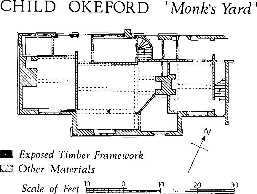
Child Okeford, 'Monk's Yard'
Above a rubble plinth the timber framework is exposed in the W. half of the N. wall. Two original wall posts, corresponding with roof trusses, have lightly moulded external corbels at the top; pegged to them is a chamfered overhanging wall-plate. Apart from these members most of the original framework in the N. wall was altered and heightened in the 17th century, when a square-headed chamfered timber doorway and two timber four-light windows with ovolo mouldings were inserted; at the same time the W. extremity of the N. front was slightly curtailed, the gabled W. wall being rebuilt in brick above a Greensand plinth. The S. front has four bays, the two middle bays projecting 5 ft. in front of the end bays. The W. bay is of brick above an ashlar plinth; of the middle bays that to the W. is faced with ashlar while the other is brick-faced; the E. bay is of brick. The E. end of the house and the eastern part of the N. wall are modern.
Inside, on the ground floor, the W. bay is spanned by two 16th-century beams with wide chamfers ending in roll-stops. A fireplace and oven against the W. wall must be later than the beams because the oven masonry partly encases the roll-stop chamfers; the beams are probably coeval with the original parts of the framed N. wall, while the fireplace was presumably built at the same time as the W. wall. The next room, corresponding with the stone-fronted bay of the S. front, is spanned by three 16th-century beams with roll-stops as before. To the W. these beams rest on a partition, presumably original, which separates the two rooms; to the E. they are supported on inserted members. The adjacent bay to the E. has been considerably altered and its original form is lost; at present it contains two back-to-back fireplaces and a large brick chimney-stack. It is probable that the W. fireplace was originally much deeper and that its bressummer supported the ends of the ceiling beams in the second bay. In the E. bay the ceiling is supported on deep—chamfered beams that are probably of the 17th century. The stairs, in the N. part of the third bay, have no early features and the first floor is unremarkable. The roof rests on four trusses, that to the E. being set at a lower level than the others and retaining traces of smoke blackening; this suggests that the E. bay may have been single-storied until the 17th-century floor was inserted.
(8) Hanford Farm (83941164), house, is a two-storied brick building of the late 18th or early 19th century. Until recent modernisation the symmetrical W. front was of three bays, with a central doorway with flanking sashed windows on the ground floor, and corresponding casement windows on the first floor.
The bowl of a 13th-century octagonal stone Font formerly stood in a scullery at the back of the farmhouse but it is now in the garden. The sides are vertical for about half the depth of the bowl and splayed inwards below that level. Each side is decorated with a roll-mould at the top and with a recessed trefoil-headed panel below; each angle has a moulded capital which presumably corresponded with a shaft worked on the stem, now missing.
(9) Fontmell Farm (82961478), house, 380 yds. N.E. of (2), is an early 18th-century two-storied farmhouse, with brick walls with rubble plinths and ashlar quoins; the roof is mostly of stone-slates. The entrance, in the W. part of the six-bay S. front, has a 19th-century gabled brick porch with ashlar quoins and a chamfered elliptical stone head to the opening. The square-headed doorway inside the porch has a chamfered stone lintel and jambs. Traces of another doorway occur in the E. part of the S. front. The level of the first floor is marked by a brick platband.
Monuments (10–15)
The following monuments are of the 17th or early 18th century and, unless otherwise described, are two-storied with thatched roofs.
(10)Gold Hill Cottage (83071327) retains the original flint and rubble walling at the back but was refronted in brickwork in the late 18th or early 19th century. The cottage has recently been remodelled.
(11) Cottage (83301304) has a modern slated roof and brick walls that were evidently refaced in the 19th century. The main ground-floor room has a six-panel ceiling with intersecting deep-chamfered beams and appears to be of the 17th century.
(12) Cottage, adjacent to the foregoing and perhaps a little later in date, has a brick front, but the rear and side walls are of rubble and flint.
(13) Cottage (83461254), originally of three ground-floor rooms but extended N. by another room in the 18th century, is built in its original parts of banded brick and flint. The ceiling beams are stop-chamfered.
(14) Farmhouse (83451239), with rendered brick and rubble walls, appears to be of the early 18th century. The original casement windows, three in each storey of the N. front, have tenoned and pegged timber frames. The N. doorway, walled up internally, has a heavy beaded oak frame and a plank door. Inside, the house has been greatly altered, but an open fireplace survives near the centre of the range. A lead rainwater head in the garden is dated 1798.
(15) Cottage (83681228), retains heavy intersecting chamfered ceiling beams and the remains of a plank-and-muntin partition.
Monuments (16–20)
The following monuments are of the later 18th century. All are two-storied and, unless otherwise described, have brick walls and thatched roofs.
(16) Cottage (83381298), one of a row, is earlier than the cottages on either side of it and was until recently distinguished by a somewhat massive chimney-stack at the S. end.
(17) Cottage, adjacent to the foregoing on the S.
(18) Inn (83471276), with a symmetrical front of three bays. The widely spaced original sashed windows have been supplemented by modern openings; the eaves have a moulded plaster cove.
(19) Cottages (83481258), two adjoining, have walls of squared and coursed rubble; that to the N. is rendered.
(20) House (83521241) has slated roofs. In the 19th century the N.E. wing was rebuilt and another house was added to the S.
Early 19th-century buildings include a house, 50 yds. N.W. of the church, of two storeys with a symmetrical brick front and slated roofs; also a small cottage, subsequently enlarged, immediately N. of (18); also an inn (83471243); also two cottages 70 yds S. W. and the same distance W. of (4). A group of two-storied brick cottages at Gold Hill has the appearance of mid 19th-century development and is probably connected with the brickworks which formerly existed in that place.
Mediaeval and Later Earthworks
(21) Cultivation Remains. Little is known of the open fields of Child Okeford. Names on the Tithe Map of 1840 suggest former North and South Fields; enclosure probably went on over a long period of time since a number of isolated strips still existed in 1840. Ridge-and-furrow of these fields remains in a number of places, especially in Child Okeford Park (837125), where there are at least five interlocking furlongs with ridges 7 yds. to 9 yds. wide. Strip lynchets, probably marginal to the main open fields, remain in two places on Hambledon Hill: on the N.W. spur (842130) and on the S. spur (843121–845121).
Nothing is known of the date of enclosure of the open fields of Fontmell Parva. Near Fontmell Farm (828148, 833148) there are extensive remains of ridge-and-furrow, consisting of butting furlongs with reversed-S ridges up to 12 yds. wide.
Roman and Prehistoric
(22) Hambledon Hill Iron Age Hill-Fort (845125) is one of the most impressive earthworks in southern England (Plate 129); its multiple ramparts, enclosing an area of 31 acres, occupy the whole of the prominent N. spur of the hill between 460 ft. and 623 ft. above O.D. (see illustration on P. xxxix of the preface). The sequence of development and the abundant occupation remains within the fort are of particular interest, as is its close proximity to the even larger hill-fort on Hod Hill (Stourpaine (10)). No recent or extensive excavations have been made on the site, but in 1894 Edward Cunnington dug in the interior, apparently in the central section, and produced Romano-British and earlier material, including pottery, quern fragments and sling-stones (Dorset Procs. XVI, 1895, 156–7). The Durden Catalogue mentions Roman articles from Hambledon, including iron saws, bronze fibulae, knives and several coins of Constantine. Abundant Iron Age 'A' pottery has been found under the inner rampart near the N. entrance. Quarrying has partly destroyed this entrance but elsewhere the hillfort has escaped serious damage. At the extreme N. of the hill-fort 'Celtic' fields (Group (62)) protrude from under the defences. A full description of the earthworks appears in Wessex from the Air, by O. G. S. Crawford and A. Keiller (1928), pp. 44–55.

Child, Okeford. (22) Hambledon Hill Iron Age Hill-fort. Profiles
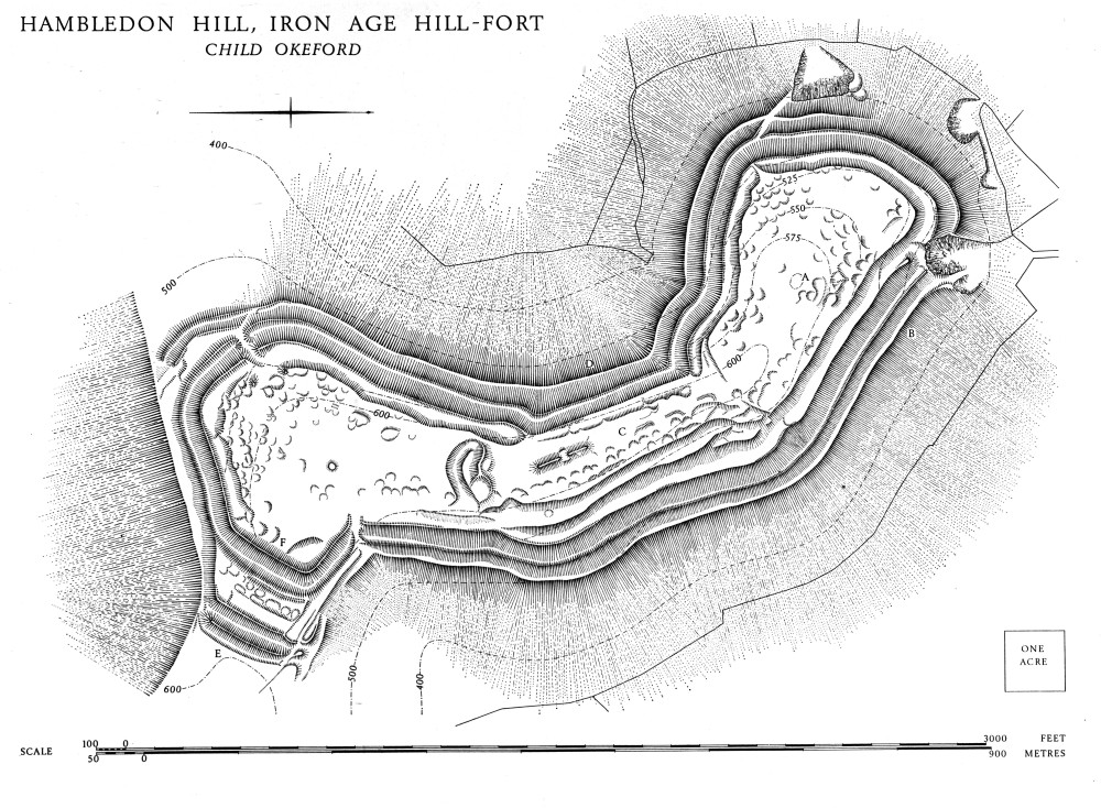
Hambledon, Hill, Iron Age Hill-Fort, Child Okeford
Topography has largely determined the bow-shape of the hill-fort, which adheres closely to changes in direction of the northern spur. The latter is level, but long, narrow and steepsided, permitting expansion in one direction only, to the S. Successive enlargement has contributed to the present irregular shape of the fort, which falls clearly into three sections, northern, central and southern, marked by changes in the alignment of the ramparts and further emphasised by the remains of two earlier cross-ramparts within the interior. The fort measures 3,000 ft. overall from N. to S. but not more than 1,000 ft. from E. to W. and often much less. In consequence the proportion of rampart length to enclosed area, 2,300 yds. of inner rampart to 31 acres, is in marked contrast to Hod Hill where 2,050 yds. of rampart enclose 52 acres. With the exception of the flat spur top, at its broadest in the southern section, much of the interior of the fort is on a pronounced slope, particularly in the N. section.
The fort is defined by two main ramparts, with external ditches and with further scarping below the outer ditch for the greater part of its length. For much of their circuit the ramparts have been produced by scarping the steep natural slope, thus involving the minimum of building. The surviving crest of the rampart rarely exceeds 4 ft. in height on the inside, and whole stretches of the inner rampart are merely terraces, but from outside these ramparts present a formidable obstacle, measuring up to 70 ft. on the scarp. Immediately inside the inner rampart runs a continuous quarry area in the form of a terrace cut into the slope; this no doubt made movement easier within the interior and gave cover to the defenders as well as providing material for the rampart. At the S. end of the hill-fort, where slopes are gentler, the defences are of normal bank and ditch construction, the inner bank rising 30 ft. above its ditch bottom; here the internal quarry ditch is deeper and less regular. Beyond the counterscarp bank are massive outworks, comprising twin banks and ditches, crossing the neck of the spur where it joins the main mass of the hill, the most vulnerable point of the defences.
There are three entrances, differing in siting and form. The northern, now largely destroyed by a quarry, is sited below 500 ft. O.D. on a very steep slope; it appears never to have been more than a simple gap, the steep slope rendering it difficult of approach. The S.W. entrance is carefully sited on a local rise in ground level, the ramparts dipping away from it on either side. It is approached from the E. along the shoulder of the slope at the foot of the ramparts and consists of a terraced ramp within a hornwork 250 ft. long. It leads up a gentle slope before turning sharply to pass at a steeper slope through the middle and inner ramparts; the latter has a slight inturn. The S.E. entrance is not situated on the neck of the spur, facing the obvious line of approach from the S.E., but some distance to the N. where it faces into a steep combe. It consists of a simple gap through the middle and inner ramparts, the latter slightly inturned, and it is closely integrated with the outworks on the neck of the spur. Successive attempts to strengthen the defences have involved moving the approach way nearer to the shoulder of the slope, and eventually on to a ledge below the shoulder.
With the exception of a long barrow (23) and a round barrow (25), the interior features of the hill-fort consist mainly of hut platforms: 82 in the northern section, 45 in the central section, and 80 in the southern section. They are most clearly marked where the slopes are steep, but cover much of the interior. The most notable concentration of platforms is in the S.W. corner of the hill-fort. The platforms vary but little, except in size, floors ranging from 15 to 45 ft. across; basically they are areas levelled into the slope to provide sites for huts. Their curving rearward scarps naturally vary in height with the steepness of the slope. In certain cases the excavated material appears to have been used to level up the floor along the forward edge. The largest hut site is set into the southern cross-rampart and is notable for its high standard of finish. Another large platform stands immediately within the S.W. entrance.
It is obvious from the surface remains that there were at least three main structural phases. The first fortification occupied the most northerly part of the spur, extending as far as the northern cross-rampart. The latter consisted of a single bank and ditch but only shallow traces of the ditch survive. In addition to crossing the neck of the spur the fortification almost certainly enclosed the whole spur end, about 12 acres, on the line of the present inner rampart. In the very beginning, however, it may have been no more than a cross-dyke. During the second phase the defences were extended southwards on a different alignment as far as the southern cross-rampart, taking in a further 8 acres and including the long barrow. The rampart again consisted of a single bank and ditch separated by a narrow berm but this time of more massive proportions. The remaining fragments of bank and ditch have been much altered, the ditch is partly filled and a large hut platform has been inserted into the bank. An entrance may have existed E. of this feature.
In the final phase the hill-fort was extended to occupy the whole spur. The S.E. and S. W. entrances were constructed and on the western side of the central section the second phase ramparts were abandoned and others were built further down the slope. The second main rampart with its external ditch was also added, together with the S.E. outwork. The latter was modified at least once in an attempt to strengthen this weakest point of the hill-fort. At first it appears to have comprised only the inner bank, as far as the marked change in height and direction near its N.E. end; the entrance way would then have followed the approximate line of the present path. Subsequently, the outwork was strengthened by the extension of the inner bank north-eastward to the shoulder of the slope, and by the addition of the outer bank and ditch. Entry was then by means of a narrow ledge, still visible, along the steep slope below the end of the outwork.
Neolithic Causewayed Camp, see Iwerne Courtney (19).
(23)Long Barrow (84531265), is prominently sited at 620 ft. Hambledon Hill, and lies within the ramparts of the Iron Age hill-fort. It is aligned almost due N.—S. (345°) by reason of the site and is strikingly regular in plan and profile, except for an undated gash across it just N. of centre. The parallel-sided mound, 240 ft. long and 55 ft. wide, is nearly 6 ft. high and fairly level along its length, with steep straight sides rising to a narrow flat top. The side ditches, extending the full length of the mound, are now visible only as slight depressions.
(24) Long Barrow (84891207) on Hambledon Hill, at about 590 ft. O.D. on a gentle S.-facing slope, just below the highest part of the hill, lies within the earthworks of the Neolithic causewayed camp. Its N.—S. alignment (358°) does not appear to have been determined by topography. Short and parallelsided, it is about 85 ft. long and 43 ft. wide, rising in height from 3½ ft. at its N. end to 7 ft. at its S. end, part of which has been quarried away. In cross profile it is steep and straight sided with a narrow top. There are traces of parallel side ditches, clear on the W. but much disturbed on the E. (Plate 132).
(25) Bowl Barrow (84521240) on Hambledon Hill, within the S. end of the hill-fort; centre disturbed; traces of ditch on S.; diam. 40 ft., ht. 1½ ft.