An Inventory of the Historical Monuments in Dorset, Volume 5, East. Originally published by Her Majesty's Stationery Office, London, 1975.
This free content was digitised by double rekeying. All rights reserved.
'Alderholt', in An Inventory of the Historical Monuments in Dorset, Volume 5, East(London, 1975), British History Online https://www.british-history.ac.uk/rchme/dorset/vol5/pp1-2 [accessed 30 April 2025].
'Alderholt', in An Inventory of the Historical Monuments in Dorset, Volume 5, East(London, 1975), British History Online, accessed April 30, 2025, https://www.british-history.ac.uk/rchme/dorset/vol5/pp1-2.
"Alderholt". An Inventory of the Historical Monuments in Dorset, Volume 5, East. (London, 1975), British History Online. Web. 30 April 2025. https://www.british-history.ac.uk/rchme/dorset/vol5/pp1-2.
In this section
AN INVENTORY OF THE ANCIENT AND HISTORICAL MONUMENTS IN EAST DORSET
Arranged by Parishes
The group of four figures following each parish heading gives the position of the parish church on the National Grid, permitting easy location of the place on the one-inch O.S. map at the end of the volume. The next line indicates the sheets of the six-inch O.S. map (edition of 1960) which relate to the parish. Each Monument in the Inventory is located by a six or eight-figure reference to the National Grid.
In architectural descriptions of churches, the parts of the building are taken in the order E. to W. and N. to S.; in descriptions of houses the exterior precedes the interior. Architectural plans have a uniform scale of 24 ft. to the inch, except for a few key-plans at approximately 48 ft. to the inch. Hatching symbols used to indicate dating are uniform throughout the volume. Construction since 1850 is termed modern.
Information now impossible to verify and derived from literary sources, usually Hutchins, is enclosed in square brackets. The date given in the description of a funerary monument is that of the death of the person first commemorated; if known, the date of erection of the monument is added; surnames in round brackets are maiden names.
Apart from Roman Roads and 'Celtic' Field Groups which are described separately (the former in the Sectional Preface, the latter at the end of the Inventory), the Ancient and Historical Monuments of East Dorset are listed below under the names of the twenty-five civil parishes in which they occur.
1 ALDERHOLT (1012)
(O.S. 6 ins., SU 01 SE, SU 11 SW)
Alderholt, with an area of 3,768 acres, is the easternmost parish in the county, forming a promontory into Hampshire. Bagshot Sands in the S. and S.E. of the parish result in extensive heathlands which rise more than 300 ft. above sea-level; the N. part is on London Clay, except for a narrow strip of Reading Beds along the N. border. These formations give rise to gently undulating, heavily forested land, draining N.E. to the Ashford Water.
The parish came into existence in the 19th century, before which the land was part of Cranborne. Little is known of the history of the area. The pattern of scattered settlement in the N., with winding lanes, isolated cottages and farmsteads and small irregular fields, probably indicates slow extension of settlement accompanied by gradual clearance of forest and waste. In the E., where the field boundaries are rectilinear, the land was enclosed from the heathland in 1858 (Hutchins III, 383; Enclosure Award, 1858, D.C.R.O.).
Ecclesiastical
(1) The Parish Church of St. James, near the middle of the parish, comprises Chancel, Nave and Vestry; the walls are of Heathstone rubble and the roofs are slated and tiled. The nave was built in 1849 and the chancel and vestry were added in 1922.
Fitting—Plate: includes a communion cup of the usual Elizabethan form, with the Exeter assay mark of 1576; it was acquired after 1850.
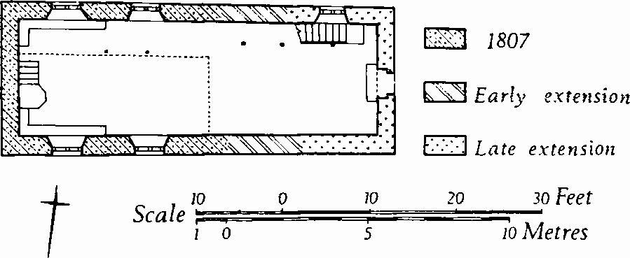
The Church, Plan
(2) Ebenezer Chapel (09061211), at Cripplestyle, nearly 1 mile S.W. of (1), has walls of cob and of brick, and a thatched roof. It is of considerable interest as a little changed example of a simple rural meeting-house of the early 19th century. The building was opened for worship in 1807 and was extended eastwards and provided with galleries at two periods during the 19th century. In 1888 it was superseded by a new chapel some 300 yds. to the N., but the old building continues to be used occasionally. The E. front, which alone is brick-faced, has a segmental-headed doorway and in the upper part a plain three-light window with timber surrounds and leaded glazing. The S. windows, similar to that on the E., have two-centred heads and are each of two pointed lights with a spandrel light. The corresponding N. windows are also similar, but square-headed to allow room for the soffit of the gallery inside; the window beside the gallery stairs is segmental-headed.
Inside, the fittings are extremely plain. The hexagonal pulpit on the W. is of deal, with panelled sides and with a plain flight of stairs with a moulded handrail. The galleries rest on chamfered wooden posts. The E. gallery has a panelled front; that on the N. is boarded.
Secular
(3) Alderholt Park (11411338), house, of two storeys with attics, has brick walls and slate-covered roofs. It was advertised as new-built in Salisbury Journal, Dec. 17th, 1810, but it is not shown on O.S. 1811. The plan is of class U. The early 19th-century E. front appears to have been symmetrical and of three bays, with a round-headed central doorway and square-headed three-light sashed windows. Later in the 19th century the house was extended on the S. and W., the windows were altered and the roof was rebuilt.
(4) Home Farm (12031361), house, of one storey with attics, has walls partly of brick and partly timber-framed, and a thatched roof. The original building, a cottage with a class-I plan, is of the 17th century; a room at the S. end of the range was added later in the same century. Above the ground-floor window heads the walls are of timber framework. Inside, some chamfered beams are exposed.
(5) Cottage (11981359), of one storey with attics, is built with materials similar to the foregoing and is of the 17th century.
(6) Cottage (11891392), of two storeys, with brick walls and a tiled roof, is of the first half of the 18th century.
(7) Cottages (12451328), two adjacent, of two storeys with brick walls and tiled roofs, were built in 1709. The building was originally a single dwelling, with a class-T plan. The S. front was symmetrical and of three bays, with a first-floor plat-band, square-headed casement windows in both storeys and a central doorway; a date-stone is set over the central doorway. For conversion into two tenements a doorway was inserted on the E. of the central opening. Inside, the two ground-floor rooms have chamfered beams with ogee stops. The original stairs are on the S. of the E. chimneybreast.
(8) Cottages (12501330), two adjacent, are single-storeyed with attics and have rendered walls and thatched roofs; they are of the late 18th century.
(9) Cottages (12631263), pair, of two storeys with cob and brick walls and with thatched roofs, are of the late 18th century. The plans are uniform and of class S.
(10) House (10811396), of two storeys with brick walls and a tiled roof, was built c. 1800. The S. front is symmetrical and of three bays, with a central doorway and with sashed windows in each storey. The plan is of class T.
(11) Cottages (08321341), pair, with brick walls and tiled roofs, are of the late 18th century and have recently been combined as a single dwelling. The N. front has a plat-band and a moulded brick cornice.
Post-Mediaeval Earthworks
(12) Enclosure and Platform (09281105), in Telegraph Plantation, 2/3 mile S. of (2), lie just above the 300 ft. contour on a prominent hill and are the remains of a station in the early 19th-century semaphore telegraph between London, Portsmouth and Plymouth (Dorset Procs., XI (1890), 135). The station is represented by a low bank, much damaged by trees, bounding an area 40 yds. by 50 yds. At the centre of the area is a platform 30 ft. square. (Cf. Chalbury (4), p. 3.)
Prehistoric Earthworks
(13) Bowl Barrow (10711047), on Cranborne Common, lies at 225 ft. above O.D. on a low spur of the Bagshot Beds; it is 36 ft. in diameter and 2½ ft. high.
A former barrow on the parish boundary with Verwood (09631063) has been destroyed by afforestation, and one on the E. of the village (12171253) has perished in the construction of houses. 'King Barrow' (09431225) is a natural mound.