An Inventory of the Historical Monuments in Dorset, Volume 5, East. Originally published by Her Majesty's Stationery Office, London, 1975.
This free content was digitised by double rekeying. All rights reserved.
'Hinton Martell', in An Inventory of the Historical Monuments in Dorset, Volume 5, East(London, 1975), British History Online https://www.british-history.ac.uk/rchme/dorset/vol5/pp30-31 [accessed 30 April 2025].
'Hinton Martell', in An Inventory of the Historical Monuments in Dorset, Volume 5, East(London, 1975), British History Online, accessed April 30, 2025, https://www.british-history.ac.uk/rchme/dorset/vol5/pp30-31.
"Hinton Martell". An Inventory of the Historical Monuments in Dorset, Volume 5, East. (London, 1975), British History Online. Web. 30 April 2025. https://www.british-history.ac.uk/rchme/dorset/vol5/pp30-31.
In this section
9 HINTON MARTELL (0106)
(O.S. 6 ins., SU 00 NW, SU 00 SW, ST 90 NE)
Hinton Martell, with an area of 1,554 acres, lies some 4 miles N. of Wimborne Minster on the E. bank of the R. Allen. In the W. part of the parish the land is Chalk, rising from 100 ft. at the river to 200 ft. above O.D.; further E., Reading Beds and London Clay overlie the Chalk at about the same altitudes; this land is drained by streams flowing S.E. The village, of mediaeval origin, stands in the N. of the parish at the junction of the Reading Beds and the Chalk. There may be evidence of mediaeval occupation in the wooded S.E. corner of the parish, on the site now occupied by 'Gaunt's House', a 19th-century building. Cottages at Gaunt's Common reflect late 18th and early 19th-century encroachment on the common lands. The open fields were enclosed in 1798 (Award, D.C.R.O.).
Ecclesiastical
(1) The Parish Church of St. John, at the N.E. end of the village, was rebuilt in 1869, but it incorporates reset features from an older building. In the western part of the S. wall of the Chancel is a restored early 14th-century window of two trefoil-headed lights with a plain spandrel light under a two-centred head. In the S. wall of the Nave are two late 15th or early 16th-century windows, each of three cinquefoil-headed lights under square heads with labels; the eastern label has returned stops and the western label head-stops. In the second stage of the Tower, the S., W. and N. sides have each a 15th-century window of one trefoil-headed light.
Fittings—Chair: with turned front legs and shaped arms, panelled and enriched back, 17th century. Chest: of oak, with panelled sides, late 18th century. Font: of Purbeck stone, with octagonal bowl having, on each face, two shallow recesses with two-centred heads, on plain octagonal stem and chamfered octagonal base, probably 13th century. Monuments: In churchyard, on W. of tower, (1) of William Marten, 1632, (2) of Sarah Marten, 1712, (3) of Elizabeth, wife of John Newman, 1690, headstones.
Plate: includes silver cup and cover-paten, each with inscription and assay mark of 1634, engraved with shield-of-arms and crest of Hastings. Royal Arms: painted on panel, 1714–1801. Sundial: Reset in S. wall of tower, of Purbeck stone with restored iron gnomon, given by William Redman, 1636 (S.D.N.Q., V (1896), 147). Tables of Decalogue: Two round-headed wooden panels with gilt lettering on black, late 18th or early 19th century.
Secular
(2) Gaunt's House (01640438), of two storeys with brick walls with stone dressings and with slate-covered roofs, dates from 1809; in 1887 it was enlarged, refaced and extensively altered, and little remains visible of the mansion illustrated by Hutchins (III, opp. 244). In the symmetrical five-bay N.W. front the proportions of the windows have been altered and the doorway with an Ionic portico has been removed. The former N.E. front has been masked by late 19th-century additions; the S.E. front alone appears to retain its original form. A Venetian window with a Portland stone surround in the S.W. elevation may be original, but reset. A view of the house c. 1823 appears in J. P. Neale's Seats of Noblemen and Gentlemen, Vol. I, No. 53.
Inside, the principal rooms retain early 19th-century doors and window-shutters with moulded and beaded panels; plaster cornices with classical enrichment also survive; the chimneypieces are of 1887.
The house was formerly surrounded by a Moat, probably mediaeval in origin; traces of it survived in 1868 (Hutchins III, 245) and a ha-ha on the S. and E. of the house may incorporate parts of it.
(3) Manor Farm (01310611), house, of two storeys with brick walls and tiled roofs, is of c. 1800. Inside, the plan is of class U. The two N. ground-floor rooms retain original chamfered ceiling beams. The front range, on the S., was rebuilt in the second half of the 19th century.
(4) The Old Rectory (01390606), of two storeys with brick walls and tiled roofs, is of early 18th-century origin. The E. elevation, of three bays with the middle bay projecting, was perhaps originally symmetrical, but the northern bay is now occupied by an early 19th-century two-storeyed bow window; this elevation has a plinth, plat-band and dentilled cornice, and sashed windows. A further bay on the N., with a three-light sashed window in the lower storey and with one of two lights above, is of the early 19th century. Inside, some original panelling is preserved, together with a fireplace with a moulded stone surround.
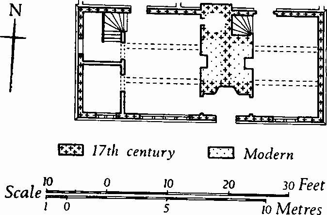
(5) House (01410614), of one storey with attics, has timber-framed walls with brick nogging, and a thatched roof; it dates from the 17th century. The original plan is likely to have been of class J and the house retains a large central chimney-stack; later chimneystacks have been built against the gabled E. and W. end walls of the range.
(6) Cottage (01340604), of one storey with attics, has walls partly of timber framework and partly of cob, and a thatched roof; it is of 17th-century origin, with extensive modern additions. Inside, the plan appears originally to have been of class S. A chamfered beam is exposed.
(7) Cottage (01230610), of one storey with attics, has timber-framed walls with brick nogging, now rendered, and a thatched roof; it is of the 17th century and has a class-J plan. Inside, a chamfered beam with shaped stops is exposed.
(8) Cottage (01280612), of one storey with attics, has cob walls and a thatched roof; it is of the late 17th century and has a class-J plan. Inside, the main room has a chamfered beam with shaped stops.
(9) Cottage (01310606), of one storey with an attic, has cob walls on a brick plinth, and a thatched roof; it is of the the late 18th century. The plan is of class T and the N. front is symmetrical and of three bays. One room has a chamfered beam with shaped stops.
(10) Cottage (01250612), of two storeys with brick walls and a thatched roof, is of the late 18th century. The symmetrical three-bay S. front has segmental-headed openings.
(11) Cottage (01860632), at Uppington, of one storey with an attic, has brick walls and a thatched roof; it is of the early 18th century and has a class-S plan. The S. front is of two bays with a central doorway.
Monuments (12–16)
Unless otherwise described, the following late 18th or early 19th-century cottages at Gaunt's Common are single-storeyed with attics and have cob walls and thatched roofs.
(12) Cottage (02500598), has the S. front in brickwork.
(13) Cottage (02350549), with a class-S plan, contains a beam carved with the date of 1782, probably the year of construction.
(14) Cottage (02250537).
(15) Cottages (02270532), two adjacent.
(16) Cottage (02270524), of two storeys, was built c. 1800.
Mediaeval and Later Earthworks
Moat, at Gaunt's House, see Monument (2).
Prehistoric
Monuments (17–26), Round Barrows
High Lea Farm Group comprises at least ten barrows sited in a field, about 135 ft. above O.D., on a gentle N.W. slope falling to the R. Allen. Only (17) and (26) survive as earthworks; the others form a scatter in the same field and are visible as soilmarks on an air photograph (N.M.R., ST 9906/1).
(17) Bowl (99930613), in the S.W. corner of the field; diam. 95 ft., ht. 4½ ft.
(18) Barrow (00020612), 100 yds. E. of (17); diam. about 35 ft.
(19) Barrow (00000625), 140 yds. N.E. of (17) ; diam. about 45 ft.
(20) Barrow (00030625), 50 yds. E. of (19); diam. about 27 ft.
(21) Barrow (00010631), 70 yds. N.N.E. of (19); diam. about 45 ft.
(22) Barrow (00030632), immediately N.E. of (21); diam. about 55 ft.
(23) Barrow (00120621), 90 yds. E.S.E. of (20); diam. about 45 ft.
(24) Barrow (00160630), 60 yds. N.E. of (23); diam. 60 ft.; ploughed out.
(25) Barrow (00190625), 100 yds. N.N.W. of (24); diam. 40 ft.
(26) Bowl (00230640), partly cut by a track and damaged by ploughing; diam. 110 ft., ht. 2½ ft.