An Inventory of the Historical Monuments in Dorset, Volume 5, East. Originally published by Her Majesty's Stationery Office, London, 1975.
This free content was digitised by double rekeying. All rights reserved.
'Shapwick', in An Inventory of the Historical Monuments in Dorset, Volume 5, East(London, 1975), British History Online https://www.british-history.ac.uk/rchme/dorset/vol5/pp57-64 [accessed 30 April 2025].
'Shapwick', in An Inventory of the Historical Monuments in Dorset, Volume 5, East(London, 1975), British History Online, accessed April 30, 2025, https://www.british-history.ac.uk/rchme/dorset/vol5/pp57-64.
"Shapwick". An Inventory of the Historical Monuments in Dorset, Volume 5, East. (London, 1975), British History Online. Web. 30 April 2025. https://www.british-history.ac.uk/rchme/dorset/vol5/pp57-64.
In this section
17 SHAPWICK (9300)
(O.S. 6 ins., ST 90 SW, ST 90 SE)
This parish, of some 3,000 acres and roughly square in outline, lies on the N.E. bank of the R. Stour; the land, entirely Chalk, rises from 80 ft. above O.D. at the river to 300 ft. in the N. The village is a moderately compact nucleated settlement on the broad riverterrace. Its compactness reflects the restriction imposed by open fields upon the development of outlying farms; the fields remained unenclosed until 1813 (Award, D.C.R.O.). The prehistoric hill-fort of Badbury Rings, and associated barrows and Iron Age and Romano-British settlements, are especially noteworthy.
Ecclesiastical
(1) The Parish Church of St. Bartholomew, close to the river on the S.W. of the village (Plate 2), has walls of flint and rubble with ashlar dressings of Purbeck stone and Heathstone; the roofs are tiled and stone-slated. The N. wall of the Nave and archways to the North Chapel are of 12th-century origin. In the 14th century the S. side of the nave was rebuilt, the South Porch was added and the greater part of the West Tower was built. The N. chapel was rebuilt early in the 15th century, and the W. tower was finished later in the same century. Early in the 16th century the N. chapel was extended eastwards and heightened, an archway was formed in the wall between the chapel and the chancel, and the eastern arch from the nave to the chapel was rebuilt. The North Porch is probably of the 16th century. In 1878 the church was restored and the Chancel was largely rebuilt.
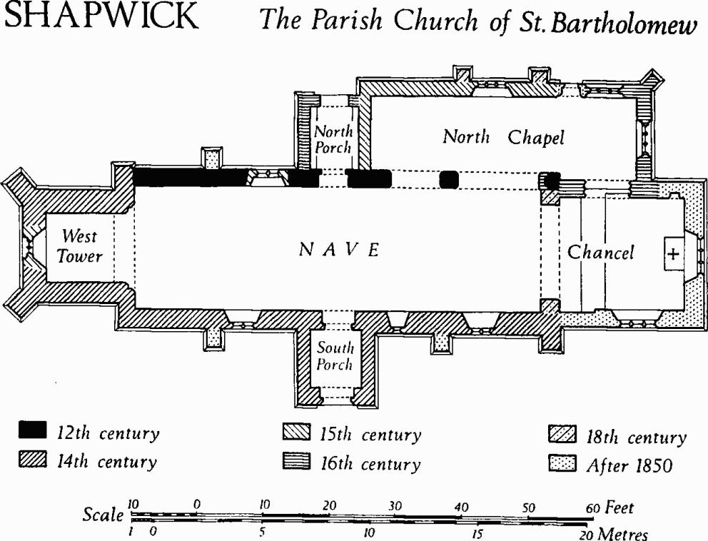
Shapwick, the Parish Church of St. Bartholomew
The nave and tower are good examples of local 14th-century building. Interesting late mediaeval brasses are preserved.
Architectural Description—The Chancel has, on the N., a 16th-century archway with a panelled two-centred head and continuous jambs, partly restored in 1878. The roll-moulded two-centred chancel arch of 1878 rises from plain responds; a 19th-century drawing preserved in the church shows these responds supporting an elliptical arch with a keystone, suggesting that they are of the 18th century.
The N. wall of the Nave has at the E. end a panelled two-centred arch, similar to that on the N. of the chancel, rising from plain chamfered responds; the E. respond has a rounded impost, that on the W. is chamfered. Adjacent on the W. is a 12th-century archway of one order, with a lightly chamfered round head and chamfered responds with chamfered imposts. The 12th-century N. doorway has a round head with a narrow chamfer ending in shaped stops; the jambs are plain; the semicircular rear-arch has been chamfered subsequently. Further W. is a late 15th-century square-headed window of two cinquefoil-headed lights; the adjacent square-set buttress is of 1878. The S. wall of the nave has a 14th-century single-stage E. buttress with a weathered head and a chamfered plinth; two other buttresses on the S. wall are of 1878. The easternmost S. window is of the 14th century and of two trefoil ogee-headed lights with a small quatrefoil spandrel light under a horizontal lintel; the lower part of each main light is blocked; the rear-arch is segmental. Further W. is a similar window of one light with a two-centred rear-arch. The S. doorway has a chamfered two-centred head with continuous jambs, and a two-centred rear-arch. The westernmost S. window is similar to that of two lights previously described, but with no spandrel light.
The North Chapel has a 16th-century E. window of three lights with plain two-centred heads under vertical tracery in a casement-moulded two-centred outer head. The N.E. buttress is of one stage with a weathered head. The two 18th-century N. buttresses are of brick. The eastern window in the N. wall is square-headed and of three lights with two-centred heads in a casement-moulded surround. The adjacent doorway is of 1878. To the W. of the doorway the N. wall of the chapel for most of its height is of flint and rubble in wide bands, probably of the 15th century, but the highest courses are 16th-century rubble work similar to that of the E. bay. The window, of three cinquefoil-headed lights without tracery, is of 15th-century origin and may originally have been in the E. wall of the chapel; it is set high up in the wall and beneath its sill is a small square-headed light, now blocked. The W. gable of the chapel has a small quatrefoil loop above the N. porch roof.
The West Tower, with walls mainly of squared rubble and flint in wide bands, is not divided into stages; the N.E. and S.E. corners have stout square-set buttresses of two weathered stages; those on the N.W. and S.W. are similar, but diagonal. The tower arch is two-centred and, on the E. side, of two chamfered orders; on the W. side it has one order; the responds have chamfered imposts. The late 15th-century W. window is of two cinquefoil-headed lights with vertical tracery in a two-centred head, and a casement-moulded surround. Below the window-sill are traces of a former W. doorway. Half-way up the W. wall the tower has a chamfered square-headed loop with a shouldered rear-arch. The E., N. and S. sides of the tower have 15th-century belfry windows of two trefoil-headed lights with vertical tracery in casement-moulded two-centred heads. At the top is a plain parapet.
The North Porch has a plain elliptical-headed archway. The South Porch has a doorway with a wave-moulded two-centred head and continuous jambs.
The Roof of the N. chapel is of 16th-century origin, but extensively restored; it is of wagon form with moulded wall-plates and moulded transverse and longitudinal oak ribs. The N. porch has chamfered wall-plates and plain rafters with cambered collars; these also are of the 16th century.
Fittings—Bells: five; 1st by R. Wells of Aldbourne, 1768; 2nd modern; 3rd and 4th with Lombardic inscriptions (Raven, 141), perhaps cast in London by John Langhorne c. 1380–1400; treble, now used with clock, with black-letter inscription 'tres xpe maria johes', 15th century. Brasses: In chancel pavement, (1) of Richard Chernok [1538], priest's figure with black-letter epitaph (Plate 20); reset on W. wall of N. chapel, (2) of Mary, wife of John Oke, lady's figure with black-letter epitaph, early 15th century; (3) of John Oke, Latin verse in black-letter, 15th century (Plate 20). Chests: two; one of oak, with fielded panels and plain legs, 18th century; another of cast-iron, for registers, 19th century. Clock: In tower, of wrought iron, c. 1800. Coffin-lids: In N. aisle, of Purbeck marble, with hollow-chamfered border, top carved with cross, late 13th century. In N. wall of nave, broken and reused as building-material, two or more with double hollow-chamfered edges, mediaeval. Coffin-stools: two, with turned legs and beaded edges, 18th century.
Font: Purbeck marble octagonal bowl with two round-headed panels on each side, on stout centre shaft with eight slender corner shafts and octagonal base; late 12th century. Inscription: In leadwork of tower roof, panel with 'TR. NH. chwd. 1701'.
Monuments and Floor-slabs. Monuments: In chancel, on N. wall, (1) of Rev. Samuel Baskett, 1760, and his wife Elizabeth, 1750, wall-tablet with enriched apron, moulded cornice and cartouche with arms. In N. chapel, on N. wall, (2) of [Thomas] Hussey, [1639], wall-monument (Plate 15) with defaced inscription panel in moulded surround flanked by composite columns supporting entablature, with achievement-of-arms of Hussey flanked by angels bearing shields; below western N. window, late 15th-century recess with elliptical Purbeck marble head with traceried spandrels, containing (3) table-tomb of [Thomas Hussey, 1639], with chamfered black marble top and panelled sides with partly defaced shields-of-arms of Hussey [impaling Hanham and of Morton impaling Hopton]. In nave, on S. wall, (4) of Rev. William Sherley, 1657, marble wall-monument with shield-of-arms now defaced (Plate 16). Floor-slabs: In chancel, (1) indented Purbeck marble slab of Richard Chernock [1538], see Brasses; (2) slate slab inscribed 'Anne Butler here beneath is laid, a pious, prudent, modest maid, 1659'.
Musical Instrument: In wall-case in nave, clarinet by Barfoot of Blandford, probably late 18th century. Painting: of Rev. S. Baskett jun., oil on canvas by Stoppelaer, 1768. Plate: includes silver cup and cover-paten (Plate 22) with assay marks of 1570, and stand-paten of 1723. Recess, see monument (3). Seating: In nave includes six oak benches with moulded square-headed ends, early 16th century, made up with modern woodwork. Miscellanea: Reset in W. wall of N. porch, cross finial, formerly on E. gable of chancel, mediaeval.
Secular
(2) Market Cross (93800171), at the cross-roads about 150 yds. E. of the church, comprises an octagonal stone platform, three steps and an octagonal base-stone with panelled sides and a moulded capping; these probably are of 15th-century origin. The upper pedestal and stone cross are modern.
(3) White Mill (95810062), house and water-powered corn mill, now disused, are respectively of two and of three storeys and have brick walls and tiled roofs (Plate 27). The house appears to be of the mid 18th century and has a symmetrical N.E. front of three bays with a central doorway and with plain casement windows in both storeys; the plan is of class T. The mill, adjacent on the S.W., has segmental-headed openings and the walls have brick dentil cornices. The keystone of the archway over the mill-race is dated 1776.
(4) Bishop's Court (93580188), formerly Bishop's Farm House, of two storeys with attics, has walls of brick, Greensand and Heathstone, and tile-covered roofs. The house is largely of 1857, but a late 16th-century S.W. wing containing the kitchen appears to be part of the old manor house of Shapwick Champayne, 'the ancient seat of the Huseys . .. long since turned into a farm-house' (Hutchins III, 165).
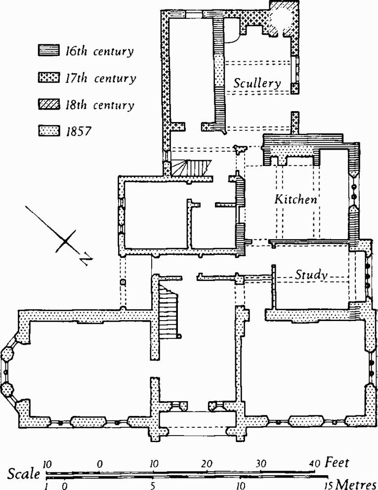
Bishop's Court
The N.E. range is wholly of 1857. Vestiges of the 16th-century building remain between modern window openings in the N.W. and S.W. elevations. The gabled S.W. wall of the kitchen, with a large chimney-stack intact to roof level, is of the 16th century. Adjacent on the S.W. is a single-storeyed 17th-century scullery, in one corner of which an 18th-century bread oven has been built; the S.E. wall of the scullery, however, appears to be of the 16th century.
Inside, the kitchen and the study have heavy ceiling beams with deep chamfers. The chambers over these rooms have chamfered beams with shaped stops.
(5) Barn (93650184), now demolished, had walls of weather-boarded timber framework above rubble plinths, and a thatched roof. The roof had tie-beam and 'sling-brace' trusses (Dorset II, lxvii). Two exit-bays projected from the S.W. side.
(6) House, (93750181), of two storeys with cob walls and a thatched roof, is of the 17th century. The N. elevation retains an original first-floor window of three square-headed lights with moulded timber mullions and head. The plan is of class J.
(7) Cottage (93780179), of one storey with an attic, has timber-framed walls and a thatched roof. It is of 17th-century origin.
(8) Cottages (93770176), two adjacent, now demolished, were two-storeyed and had walls of banded rubble and flint in the lower storey and of cob in the upper storey; the roofs were thatched. The N.W. dwelling appears to have been of 16th-century origin; in the 17th century it was enlarged on the S.E. and the adjoining tenement was built. In the 18th century the range was again extended on the S.E., with walls of banded brick and flint. The doorway of the earlier tenement had a hollow-chamfered stone surround. Inside, some chamfered beams were exposed.
(9) Cottages (93800172), two adjacent, of two storeys with brick and flint walls and with thatched roofs, are of the 18th century. The N.W. tenement has a date-stone of 1730.
(10) Cottage (93700164), now demolished, was two-storeyed and had rendered brick walls and a tiled roof; it was of the early 18th century. The N.E. front was symmetrical and of three bays with square-headed three-light casement windows flanking a central doorway, and with corresponding openings in the upper storey. The plan was of class T, but the N.W. room was unheated; this room had stop-chamfered beams.
(11) Cottage (93750161), of one storey with an attic, has walls of brickwork chequered with stone blocks, and a thatched roof. Of 17th-century origin, it was partly rebuilt in the 18th century. An attic window has an ovolo-moulded wood frame. Stop-chamfered ceiling beams are exposed.
(12) Cottage (93780166), of one storey with an attic, has cob walls with brick quoins above plinths partly of Heathstone and partly of brick and flint. It dates from late in the 18th century and has a class-S plan.
(13) Cottage (93840170), of one storey with an attic, has cob walls on a brick plinth, and a thatched roof; it is of 17th-century origin, but has been extensively modernised. The plan is of class T.
(14) Cottage (93840174), of one storey with an attic, has cob walls and a thatched roof and dates from the 17th century. Originally the plan was of class S, but it has been altered.
(15) Cottage (94030160), now demolished, was of one storey with an attic and had cob walls and a thatched roof; it was of the 17th century.
(16) Cottage (94340157), of one storey with an attic, is of 17th-century origin; it has cob walls, partly refaced in brickwork dated 1727 by inscription, and a thatched roof. The plan is of class T.
(17) Piccadilly Farm (94240171), house, now demolished, was of two storeys and had cob walls and a thatched roof. It was of the 17th century and had stop-chamfered ceiling beams.
(18) Cottage (94220174), of two storeys, with walls partly of rubble and partly of timber framework above a brick plinth and with a thatched roof, is of 17th-century origin. The upper storey was formed in the 18th century by heightening the original walls in brickwork. Stop-chamfered beams are exposed in the ground-floor rooms.
(19) Cottage (94210176), now demolished, was single-storeyed with an attic and had timber-framed walls and a thatched roof. It was built in the 17th century and retained two bow-fronted windows, with moulded heads and mullions, projecting on shaped brackets (cf. Pamphill (27)).
(20) Cottage (94030185), now demolished, was single-storeyed with an attic and had walls partly of cob and partly timber-framed, and a thatched roof. It was of the 17th century.
(21) Cottage (94060186), of two storeys with cob and brick walls and with a thatched roof, is of the 19th century. The plan is of class S.
(22) Cottage (94100186), now demolished, was of one storey and had timber-framed walls and a thatched roof; it was of the 17th century. The plan was of class S and the main room had stop-chamfered beams and wall-plates.
(23) Cottage (94130188), of one storey with attics, has cob walls refaced with 19th-century and later brickwork, and a thatched roof. It has a class-T plan and probably is of 18th-century origin.
(24) Cottages (94140191), two adjacent, now demolished, were of one storey with attics and had walls partly of cob and partly timber-framed on stone plinths; they were roofed with thatch. The N.E. cottage was of c. 1600; that on the S.W. was added later in the 17th century. Stop-chamfered beams were exposed in the ground-floor room of the earlier cottage.
(25) Farmhouse (94240199), of two storeys with brick walls and a thatched roof, is probably of early 18th-century origin and originally had a class-S plan. In the 19th century the range was extended at both ends, to N.E. and S.W. The N.E. extension may have originated as a separate dwelling, but it is now combined with the earlier house.
(26) Cottage (94290204), now demolished, was of one storey with an attic and had timber-framed walls and a thatched roof. It was of early 17th-century origin, with an extension of c. 1700.
(27) Cottage (94220208), now demolished, was of one storey with walls of cob and of brick and with a thatched roof; it probably was of the 18th century.
(28) Cottage (94180210), now demolished, was of one storey with an attic and had cob and brick walls and a thatched roof; it was built about the middle of the 18th century and had a class-S plan.
(29) Cottages (94180213), two adjacent, are two-storeyed with cob walls and thatched roofs and date from c. 1800. The S.W. tenement has been refronted in brickwork; that on the N.E. has recently been demolished.
Mediaeval Earthworks
(30) Cultivation Remains. Nothing remains of the open fields, finally enclosed in 1813 (Award, D.C.R.O.). An area of ridge-and-furrow 6 yds. to 7 yds. wide, covering some 15 acres and partly overlying a Roman settlement (31) in the N.E. of the parish, is certainly earlier than the 19th century; it probably represents a temporary extension of the arable land of Shapwick at some time in the mediaeval or post-mediaeval period.
Roman And Prehistoric
The Roman Road from Old Sarum to Dorchester bisects the parish, but its intersection with the road from Hamworthy to Bath lies ¼ mile to the N., in Pamphill.
(31) Romano-British Settlement (960029), immediately W. of Badbury Rings (34), covers about 10 acres on a gentle S. slope, about 260 ft. above O.D. The major part of the site, an irregular enclosure beside the Roman road, is bounded by a bank, nowhere more than 2½ ft. high and up to 20 ft. wide, with traces of an inner ditch in the S.W. The enclosed area is featureless except for some ridge-and-furrow (30) in the south-western half; in places this has almost destroyed the bank. To N.E., in a triangular area delimited by the enclosure, by the outer ditch of Badbury Rings and by the Roman road, are a barrow (50) and a circular earthwork. The latter, 200 ft. to 250 ft. in diameter and bounded by a low bank with traces of an outer ditch, has an irregular mound 1½ ft. high in the centre (96100300). It has been suggested that it is a disc barrow (Wessex from the Air, 60, and Pl. IV; Dorset Barrows, Shapwick (11a)), but this is extremely unlikely and it is almost certainly part of the settlement.
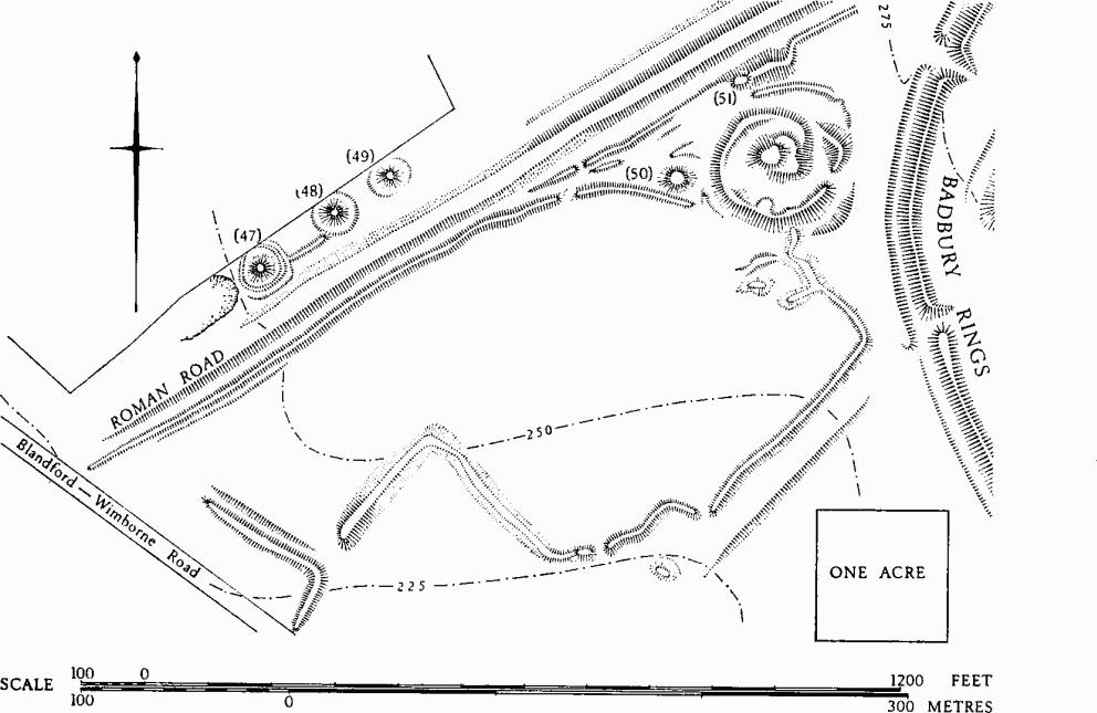
Shapwick. (31) Romano-British settlement; also Roman road and round barrows
Excavations by W. G. Wallace in 1900 and by C. G. Rudd in 1952, on and around the circular feature, revealed stone roofing slabs, painted wall-plaster and over 185 coins dating from Claudius to Arcadius, but mostly of the 4th century, as well as 21 Durotrigian silver and bronze coins. Samian ware, New Forest ware and other pottery, glass beads, bronze pins, a bracelet and a brooch were also found. The quantity of finds in so small an area is remarkable. Other Roman, Iron Age and earlier material was collected some 500 yds. to the N.E. (96420325), immediately N. of Badbury Rings. Finds are in B.M. and D.C.M.
The site, together with Badbury Rings, has been identified with Vindocladia of the Antonine Itinerary. (Hutchins III, 187; Dorset Procs., LIV (1932), 87–90; 66 (1944), 28–34; 76 (1954), 95; Arch., XCIII (1949), 25; I.A.S.B., 239, 242–3, 245; Britannia, I (1970), 61; MS. notes by C. G. Rudd in D.C.M.)
(32) Romano-British Occupation Debris (957023), found in 1914 on New Barn Farm, ½ mile S.S.W. of Badbury Rings, lay on the crest and S.E. slope of a broad Chalk ridge between 175 ft. and 200 ft. above O.D. The material includes samian and coarse pottery of the 1st and 2nd centuries. An Iron Age weaving comb, pottery and a brooch, found in the 19th century, may have come from near by (Arch. J., III (1856), 352; notes in D.C.M.). The site and the surrounding area have been heavily ploughed, but air photographs (C.U.A.P., XZ 19, 26, 27) reveal traces of enclosures and indeterminate lengths of ditch.
(33) Roman Pit and Occupation Debris (94190190), discovered in High Street, Shapwick, immediately S. of the Roman road from Badbury Rings to Dorchester, occupied a terrace of Valley Gravel, 90 ft. above O.D. A coin of Claudius and 1st and 2nd-century pottery including samian ware, and a stamped mortarium of decanius were found (Dorset Procs., 77 (1955), 138–9; 80 (1958), 106–7).
(34) Badbury Rings (964030), a multivallate Iron Age hill-fort (Plate 62), is sited prominently on a Chalk knoll rising to 327 ft. above O.D.; it commands wide views in all directions. Together with the adjacent settlement (31) it has been identified with Vindocladia of the Antonine Itinerary, and also with Mons Badonicus of Gildas. Its later history includes occupation by an army under Ethelwold, c. 899, and by the 'Clubmen' in 1645.
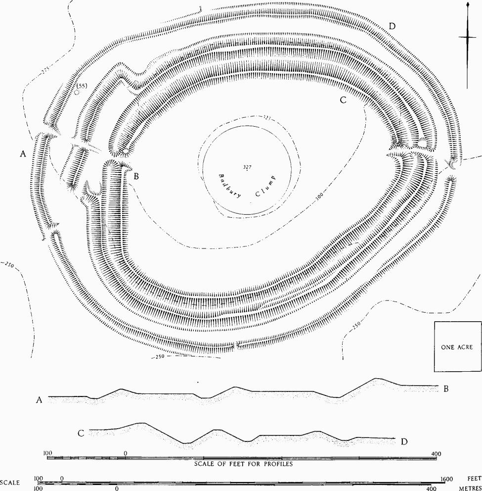
Shapwick. (34) Badbury Rings Hill-fort
The site has not been excavated, but the earthworks indicate at least two phases of construction. The first phase appears to comprise the two inner ramparts and ditches, enclosing an oval of 17 acres. The inner rampart, 60 ft. to 80 ft. wide, rises 10 ft. above the interior and up to 25 ft. above the bottom of the adjacent ditch, which is 40 ft. wide. Immediately outside is a second rampart, standing up to 18 ft. above the inner ditch and from 15 ft. to 22 ft. above the outer ditch; the latter is 40 ft. wide and up to 6 ft. deep. Both ditches have markedly V-shaped profiles. The phase-I enclosure had two entrances: on the E. is a straight gap through the ramparts, the ends of which are slightly inturned; on the W., an inturned entrance through the inner rampart and ditch is protected by a narrow, roughly rectangular barbican formed by the outer rampart, with an entrance at the S.W. corner. Near the centre of the W. side of the barbican, a later gap, perhaps Roman, is cut through the outer rampart and ditch (cf. Ashfield Gate at Hod Hill, Stourpaine; Richmond, Hod Hill II (1968), 90–1; Dorset III, 263–5).
In phase 2 the outer rampart and ditch were formed; they lie between 50 ft. and 100 ft. outside the inner defences and are considerably smaller. The rampart is 5 ft. high from the interior and up to 14 ft. high above the outer ditch; the ditch, where it survives, is up to 25 ft. wide and generally flat-bottomed. There are four gaps through the phase-2 defences. Those on the E. and S.W. are almost certainly original and are integrated with the entrances through the inner defences. That on the W. is a continuation of the (?) Roman gap in the barbican. That on the S. is relatively modern.
The interior of the hill-fort is domed and largely covered with trees and scrub. A prominent fir copse, Badbury Clump, within a low embanked circle on the summit of the knoll had already been planted when Colt Hoare visited the site c. 1820. No obviously original features are seen in the interior, but there is evidence of shallow quarrying immediately inside the inner rampart, doubtless to provide additional material for the defences. Apart from Roman coins, urns, a sword found in 1665, apparently inside the defences, and a record of small vases of Roman ware, nothing has been found on the site. A round barrow (55) lies just within the phase-2 defences on the N.W.
Selected bibliography: Wessex from the Air (1928), 58–61, incl. further bib. matter; Hutchins III, 175–7; Colt Hoare, Ancient Wiltshire (1821), Roman Aera, 35–6; Air Photography for Archaeologists (O.S. Prof. Paper No. 12, 1929), 40 and Pl. xviii; Arch. J., CIV (1947), 32–3; E.H.R., XLVIII (1932), 625; Dorset Procs., LI (1929), 104; Ibid., 66 (1944), 19–30; Journal of Celtic Studies (1958), 152–5; Britannia, I (1970), 34–82.
(35) Bank and Ditch (95600301), possibly part of an enclosure, some 600 yds. W. of (34) and immediately N.E. of the Blandford-Wimborne road, was examined by excavation in 1965 before it was levelled. A Bronze Age palisade trench was found to be overlaid by an Iron Age 'B' bank, with a ditch 5½ ft. deep on its N. side. The earthwork had been enlarged to fully defensive proportions shortly before the Roman occupation and the ditch had been deepened to 13 ft. (Dorset Procs., 87 (1965), 101–2.)
(36) Enclosure (95270153), probably prehistoric or Romano-British, appears as a soil-mark on an air photograph (N.M.R., ST 9401/1). Lying 120 ft. above O.D. on a S.W. slope, 500 yds. W. of New Barn Farm, it is roughly rectangular and measures 110 ft. by 90 ft.; a possible entrance occurs on the N. side. Air photographs reveal a number of former ditches on the undulating land which slopes down to the R. Stour, S. and S.W. of (34). They appear as crop-marks and soil-marks in discontinuous lines which occasionally intersect, but nowhere do they form any coherent pattern.
Monuments (37–62), Round Barrows
At least twenty-six barrows are known, but many have been flattened by ploughing and now appear only as soil-marks or crop-marks on air photographs. One of them, possibly (40) or (41), was the 'Badbury Barrow' which yielded remarkable finds when destroyed in 1845. Under the barrow mound, which was some 60 ft. in diameter and 9 ft. high, a central cairn of sandstone blocks was enclosed in a ring of flints bordered by a circular sandstone wall 30 ft. in diameter. Within the cairn were at least three inhumations, apparently primary, two of them with food-vessels and one with an ornamented handled pot. Also probably in the cairn were at least fifteen cremations, a few perhaps primary, but most of them secondary, some with collared urns. At the centre, a huge slab of sandstone weighing half a ton was decorated with cup marks and carvings of daggers and axes similar to those at Stonehenge (C.T.D., Pt. 3, No. 85; Arch. J., III (1846), 348–52; Ant. J., XIX (1939), 291–9; P.P.S., XXVII (1961), 294; Durden Cat., 19, No. 41). Opening another barrow in the same group, J. H. Austen found a primary cremation in a bucket urn with four lugs, in a charcoal-filled cist (C.T.D., Pt. 2, No. 31; Ant. J., XIII (1856), 447). Two barrows shown on O.S. 1811, N.E. of Crab Farm (955029), no longer exist and are omitted from this inventory.
(37) Barrow (93430328), appearing as a ring-ditch soil-mark on air photographs (N.M.R., ST 9303/1, 2), has been levelled.
(38) Bowl (94730389), S.W. of Target Wood, is now levelled by ploughing; former diam. about 40 ft.
(39) Barrow (about 94960369), appearing as a ring-ditch on air photographs (C.U.A.P., AUP 34, 36), has been levelled.
Badbury Barrow Group comprises five barrows (40–44), lying on either side of the Blandford-Wimborne road, on the gentle S.E. slope of a ridge, about 225 ft. above O.D.; (40) or (41) may be 'Badbury Barrow'. All have been heavily ploughed, but they are visible on air photographs (N.M.R., ST 9403/1; C.U.A.P., AQY 95).
(40) Bowl (94770357); former diam. 75 ft., ht. 3½ ft.
(41) Bowl (94790354), 40 yds. S.E. of (40); former diam. 70 ft., ht. 2 ft.
(42) Barrow (94830352), immediately E. of (41), shows as a ring-ditch on air photographs.
(43) Bowl (94780342), 100 yds. S. of (42); former diam. 90 ft., ht. 5 ft. Air photographs suggest a central pit.
(44) Bowl (94990350), 170 yds. E. of (42); diam. about 25 ft. Ploughed out.
(45) Bowl (95170359), now levelled by ploughing, is 40 ft. in diam.
(46) Straw Barrow (94670312), bowl, is now heavily ploughed; former diam. 65 ft., ht. 3 ft.
Badbury Rings Group comprises nine barrows (47–55), immediately W. and S.W. of Badbury Rings (Plate 62); they lie on undulating downland between 250 ft. and 275 ft. above O.D. It was once thought that (45–47) were Roman (Wessex from the Air, 58–61, Pl. IV), but this has now been disproved (Ant. J., XLV (1965), 41–7).
(47) Bowl (95830294), immediately N.W. of the Roman road; diam. 50 ft., ht. 7 ft., with a ditch 10 ft. wide and 1½ ft. deep. The earthwork is encircled by a bank 2½ ft. high with an outer ditch 1 ft. deep, but these have been shown by excavation to be post-Roman.
(48) Bowl (95880298), some 50 yds. N.E. of (47); diam. 50 ft., ht. 7 ft., with traces of a ditch.
(49) Bowl (95900300), some 35 yds. N.E. of (48); diam. 48 ft., ht. 7 ft., with traces of a ditch.
(50) Bowl (96040300), S.E. of the Roman road and immediately adjacent to Romano-British Settlement (31); diam. 60 ft., ht. 3 ft.
(51) Barrow ? (96060304), 60 yds. N.E. of (50), has been damaged by modern tracks and is cut by the side ditch of the Roman road. Oval, 30 ft. by 40 ft., ht. 1 ft.
(52) Bowl (96100311), just N. of the Roman road; diam. 30 ft., ht. 1½ ft.
(53) Bowl (96200322), 160 yds. N.E. of (52); diam. 55 ft., ht. 2½ ft., with traces of a ditch.
(54) Bowl (96270328), 110 yds. N.E. of (53); diam. 25 ft., ht. 1 ft.
(55) Bowl (96200310), immediately within the outer rampart of (34); diam. 40 ft., ht. 3 ft.
(56) Barrow (95800255), on the crest of a Chalk ridge S.W. of Badbury Rings, has been levelled by ploughing, but appears as a ring-ditch on air photographs (C.U.A.P., XZ 26, 27); diam. about 50 ft. There are suggestions of a central pit. Immediately adjacent on the E. is a length of ditch.
(57) Barrow (96030203), 400 yds. W.N.W. of Locust Clump, on a gentle E. slope, appears as a ring-ditch on an air photograph (C.U.A.P., XZ 18). This must be one of three barrows shown on O.S. 1811.
(58) Barrow (96040199), 30 yds. S.S.W. of (57), has similar characteristics.
Park Lane Group (59–61) comprises at least four barrows, all levelled by ploughing and now visible only as ring-ditches on an air photograph (N.M.R., ST 9401/1). They lie on a gentle S. slope at about 125 ft. above O.D., just S. of Park Lane. Three of the rings are interlocked and form what appears to be a triple barrow.
(59) Barrow (95390152); diam. about 75 ft.
(60) Triple Barrow (95430158), comprising three interlocking ring-ditches, are aligned N.W.–S.E. The S.E. barrow is 80 ft. in diam.; that on the N.W. is of similar size, with traces of an inner ditch about 30 ft. in diam. The central barrow, 70 ft. in diam., appears to have been inserted between the other two.
(61) Barrow ? (95180166), 220 yds. W.N.W. of (60); diam. about 35 ft.
(62) Barrow (93510255), now levelled by ploughing, appears on an air photograph (N.M.R., ST 9401/1) as a pair of concentric ring-ditches; overall diam. 75 ft.