An Inventory of the Historical Monuments in London, Volume 3, Roman London. Originally published by His Majesty's Stationery Office, London, 1928.
This free content was digitised by double rekeying. All rights reserved.
'Introduction: London after A.D. 60', in An Inventory of the Historical Monuments in London, Volume 3, Roman London( London, 1928), British History Online https://www.british-history.ac.uk/rchme/london/vol3/pp33-56 [accessed 27 July 2024].
'Introduction: London after A.D. 60', in An Inventory of the Historical Monuments in London, Volume 3, Roman London( London, 1928), British History Online, accessed July 27, 2024, https://www.british-history.ac.uk/rchme/london/vol3/pp33-56.
"Introduction: London after A.D. 60". An Inventory of the Historical Monuments in London, Volume 3, Roman London. (London, 1928), , British History Online. Web. 27 July 2024. https://www.british-history.ac.uk/rchme/london/vol3/pp33-56.
6. Roman London After A.D. 60.
After the Boudiccan revolt, London does not appear in written history until the year 296. Ptolemy, the geographer, c. 150, includes it amongst the three cities of Kent (the others being Canterbury and Richborough), and the Antonine Itinerary, compiled perhaps early in the 3rd century, emphasises the geographical dominance of London by pivoting seven of the fifteen Routes upon it. But the only certain fact relative to the life of the city in these two centuries is that the usurping emperor Carausius opened a mint there in or after 286 (see p. 187). This was probably the first of the Romano-British mints, and may even have been the only one, since none of those ascribed to Colchester, Richborough, Bitterne, Cirencester, or Wroxeter, is quite certain. The official status of London at the time is very doubtful and will be discussed in a separate Section (p. 56), but it is apparent from this and the other evidence that the commercial prosperity which had already attracted the notice of Tacitus in the 1st century had, by 286, established the city's position as a centre of financial administration. This position is emphasised by the Notitia Dignitatum which, a century or more later, assigns to London, alone of British cities, a high Treasury official. The mint itself, however, seems to have lapsed in the latter part of the reign of Constantine I and to have ceased finally in 388 after a brief revival by Magnus Maximus.
In 296 London became the centre of the campaign whereby the Caesar, Constantius Chlorus, and a military colleague named Asclepiodotus recovered Britain for the legitimate regime from Allectus, the murderer and "successor" of Carausius. The campaign is described by the contemporary writer Eumenius, whose point of view, however, is that of the ex-private secretary and panegyrist of Constantius rather than that of an impartial witness. Indeed, his enthusiasm for his patron is such that he omits to mention Asclepiodotus (who seems, in fact, to have borne the brunt of the business) and it is only with the insecure help of the summaries left by much later historians—Aurelius Victor, Eutropius and Orosius, all of late 4th- or early 5th-century date—that it is possible to reconstruct the general sequence of events. Setting forth from Boulogne, the attacking fleet appears to have sailed in two divisions, the one under Asclepiodotus towards the Solent, the other under Constantius, towards the Kentish coast. Both divisions missed their primary objective in a fog; but Asclepiodotus disembarked, probably in Hampshire, defeated and slew Allectus, and followed the usurper's fugitive mercenaries towards London, which they reached ahead of him and began to pillage. Their work was interrupted by Constantius, whose fleet had in the meantime found its way opportunely up the Thames, and (adds the panegyrist) not merely brought safety to the provincials by the slaughter of the enemy, but roused in them "an active feeling of grateful pleasure at the sight." This seemly sentiment is commemorated by the well-known gold medallion, found near Arras in 1922, recording the triumphal entry of Constantius into the city and bearing the significant legend REDDITOR LVCIS AETERNAE (p. 188n and Plate 67). (fn. 1)
The next mention of London occurs in connection with the Council held at Arles in 314, the year following the formal recognition of Christianity throughout the Empire by the Edict of Milan. To this Council came three British bishops, of whom one was Restitutus of London, presumably the first authorized occupant of the See. The only other recorded Romano-British bishop of London is one Augulus; he is merely a name in the martyrologies, where he is associated with "Augusta," the title given to the city sometime between 326 and 368 (see p. 60) and dropped after the Roman era. The association, however, does not help us to assign a date to his martyrdom, since the only anti-Christian movement of the period—that instigated by Julian—was not accompanied by active persecution. (fn. 2)
For the rest, two or three references by Ammianus Marcellinus complete the history of 4th-century London. In the year 360 serious incursions by the Picts and Scots induced Constans to send reinforcements to Britain under the command of an efficient but not otherwise praiseworthy general named Lupicinus, who landed at Richborough, "whence he proceeded to London, that he might deliberate upon the aspect of affairs and take immediate measures for his campaign." His intervention did not, however, deter the Picts and Scots from still more devastating outbreaks seven years later when they captured the commander of the northern frontier whilst German invaders slew the commander of the coastal defences in the south. Britain was at that time reduced to desperate plight. Valentinian sent one officer after another to report, and finally despatched his famous general Theodosius to the island with strong reinforcements. Like Lupicinus, Theodosius landed at Richborough and marched towards London, which had by then received the name or title Augusta. En route he divided his army into detachments, which hunted down the bands of plunderers who were devastating the countryside and in some cases actually driving cattle and chained prisoners before them. To the sufferers he restored the whole of their property " save a small portion " which he found politic to allot to his weary troops. Then " joyful and triumphant he made his entry into the city which had just before been overwhelmed by disasters, but was now suddenly re-established before it could have hoped for deliverance." Thereafter he set the administration in order, marched forth against the barbarians in the north, "entirely restored the cities and the fortresses which through the manifold disasters of the time had been damaged or destroyed " and returned to receive honours from the emperor Valentinian in Gaul. With his departure Augusta vanishes from written history, to appear once more as London in the doubtful pages of the Anglo-Saxon Chronicle under the year 457.
If we turn now to evidence of the structural development of London after A.D. 60, it is clear at the outset that, from the special circumstances of the case, we can never hope to know very much in detail. The upper Roman levels have, more often than not, been destroyed by mediæval and later builders, whilst the deepening foundations of modern ferro-concrete structures are driven relentlessly down to, and below, the natural gravel. Evidence relative to the early history of the City is thus daily obliterated at a speed which far outpaces the feeble efforts at present made to record it. As years go by, the residue of archæological material becomes less and less, and, although much very useful work can still be done if the public conscience is awakened to the need, Roman London must remain at best a broken mosaic.
From the scraps of information collected in the Inventory (p. 69), it is possible at present to produce a coherent outline only of two or three of the principal features of the town. Most striking of these is the town-wall which, if the fragmentary evidence is read aright (p. 74), was erected within half a century of the Boudiccan revolt, perhaps as the fruits of that bitter experience. The wall was some three miles in length and enclosed an area of about 330 acres, an area far in excess of that of any other Romano-British town, for Cirencester was less than 250 acres, Verulam 203 acres, Wroxeter 170 acres, and Silchester and Colchester less than 105 acres in extent. Amongst the Roman towns of Gaul and Germany, only four exceeded London in size—the Augustan cities of Nîmes (790 acres) and Autun (494 acres), and the early (? Flavian) city of Avenches, together with Trier (704 acres) which, as the Imperial capital of the West, cannot fairly be included in the same class. Of the other towns in the same provinces, Lyons (about 318 acres) approaches London very closely, but the next in size—Cologne (239 acres) and Vienne (about 214 acres)—are far exceeded. In a small degree London owed its size to the inclusion of the Walbrook within the defences, but there is ample evidence that the flanks of the stream-valley were early built upon (e.g. No. 130) and the uninhabitable space occupied by the stream must have been quite small. The whole site, with its open bridgehead-settlement in Southwark, resembled in a general way the more rugged site of Vienne, bisected also by its rivulet and facing its unfortified suburb at S. Colombe across the Rhône.
When the town-wall of London was built, it lay well outside the inhabited area, since it is nowhere known to have disturbed any evidence of previous occupation. It is possible indeed—unless later builders have destroyed the evidence in an exceptionally thorough manner—that fairly considerable stretches of land within the wall always remained open; in the N.W., on the General Post Office site, and in the E., in the vicinity of Fenchurch Street, excavations have revealed comparatively few traces of the intensive occupation which is manifest elsewhere. And consistent with this is the scarcity of structural remains outside the line of the wall. Apart from piles found mostly in the valley of the Walbrook, these remains are restricted to two walls outside Bishopsgate, a doubtful wall near Aldersgate, an alleged pavement (found before 1805) in Smithfield, and a mosaic just across the Fleet in Holborn. The density of the cemeteries which crowd upon the walls is proof that this absence of recorded extra-mural structures is not accidental. Save for the suburb in Southwark, Roman London was comfortably contained by its defences; it clung, as it clung for the most part throughout the middle ages, to the river-frontage where its shipping lay.
Next to the wall, the most important structural relic of Roman London is the Basilica (Nos. 36–41,81 and 82; pp. 115,120,127) which crowned the eastern hill where the Leadenhall Market stands to-day. The remains were surveyed by Mr. H. Hodge in 1881 and 1883, and his plans, together with a few subsequent observations, are here collated by Mr. A. W. Clapham (Fig. 3). The original plans are drawn to a scale of four feet to the inch and are accompanied by numerous notes, a series of detail-sketches of individual walls, and a general perspective view of the site, showing not only the Roman remains but also the then surviving ruins of the mediæval Leadenhall with its chapel. In spite of many lacunae, the information is considerable in volume and justifies certain tentative conclusions.
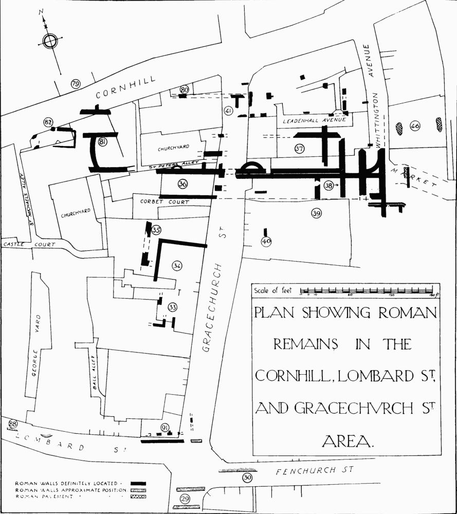
Fig. 3

Fig. 4. Leadenhall Market. General View of Excavations. From Archæologia, LXVI, by permission.
Fig. 5. Leadenhall Market. Wall No. 1. From Archæologia, LXVI, by permission.
Fig. 6. Leadenhall Market. Wall No. 4. From Archæologia, LXVI, by permission.
Fig. 7. Leadenhall Market. Wall No. 12. From Archæologia, LXVI, by permission.
It may be premised that the main walls shown on the plan belong to at least two periods which are differentiated by their diverse structure: the first and presumably earlier walls being built of rag-stone alternating with brick bonding-courses carried through the entire thickness, while the second and presumably later walls are, so far as they remain, built entirely of brick. The whole of the complex of walls (1, 2, 3, 4, 5 and 8) in connection with the main apse at the E. end are apparently of the same date. They stand on a rubble foundation at a general level of about 14 ft. below the pavement of Gracechurch Street; the walls themselves consist of four courses of bonding-tiles, at the base, followed by seven courses of squared stone and further courses of bondingtiles. A fragment of wall 4, S. of the apse, was standing over 8 ft. high above the footings. Both this wall and that numbered 2 have offsets on both sides 4 ft. above the footings, but the other walls were not standing to a sufficient height to show whether this feature was common to all. The wall across the chord of the apse and the cross-wall farther W. are nowhere represented in detail, and it is impossible now to say whether they were sleeper-walls, were carried up, or supported steps leading up to a higher level. A hole recently drilled through the southern extension of one of these two walls showed that the foundations went down to a depth of 27 ft. below street-level.
Turning now to the body of the building, it appears probable that the side walls of the original structure are represented by the outer or southern half of the thick wall on the S. and by the fragments of a parallel wall on the N. of the main building. Three facts point in this direction—(a) the footings of the still-existing pier adjoining Gracechurch Street are shown as oversailing this southern half of the thick wall and must consequently be an addition or reconstruction; (b) the suggested early walls are of equal thickness, 6½ ft. through the footings; and (c) the centre of the main apse-curve is exactly on the axial line between these two walls. The supposedly early S. wall is carried W. a distance of about 230 ft. from the W. face of the apse, where it terminates in a sloping end, the later northern half of the wall being carried a considerable distance beyond. This would appear to represent the total length of the original building. With regard to (c) it seems inevitable to conclude that the northern part of the apse was destroyed at some subsequent period and the wall continued in a straight line towards the N. An apse with a flattened end is not met with in Roman building.
That these side walls originally supported an open arcade is rendered likely by one of Hodge's notes on the northern part of the body of the building, which records the finding there of "blocks of oversailing bricks like an arch in red mortar or concrete" which were evidently fallen material, probably from the northern arcade. The evidence in regard to the aisles is somewhat inconclusive, but it may perhaps be assumed that the wall 2 represents the line of the outer wall of the S. aisle, giving an internal width of 24½ ft. The same dimension on the N. side gives almost precisely the inner lines of the wall X.
This wall, and indeed the whole of the N. side of the building, seems to have been very incompletely excavated, and the remains recorded are consequently of a very fragmentary nature. The square blocks near Gracechurch Street may possibly represent the foundations of buttresses to this wall, but this is little more than surmise; and nothing definite can be known until the sites of the houses 92–94 have been examined.
Two distinct floor-levels were observed by Loftus Brock, the lower and perhaps original pavement being of red tesserae and covered by the ashes of a great fire; the concrete only of the upper pavement was observed. A note on Hodge's plan indicates a portion of "faced mortar and concrete floor" 15 ft. below the street-level, in the body of the building. Another note by Hodge relates to paving-stones, 6 ft. 3 in. by 6 ft. 5 in., but with no indication of their precise position or depth from the surface.
The floor-level of the reconstructed building is perhaps preserved in another note of Hodge recording a "fragment of white tesserae pavement" on the sleeper-wall immediately to the E. of the still surviving pier. This would be about 13½ ft. below the modern pavement-level. On the W. side of Gracechurch Street, what appears to have been a third and later floor-level was found; it was of concrete 9¼ ft. below the street-level and 8 ft. above the footings of the main S. wall of the building.
The reconstruction and enlargement of the building consisted apparently of (a) the erection of a new S. wall adjoining and immediately to the N. of the old S. wall; (b) perhaps the reconstruction of the old N. wall on its original line; and (c) the extension of the building at least 90 ft. and probably 185 ft. (see general plan Fig. 3) to the W. of its original termination. The S. wall and its extension stand on a rubble base with an ashlar plinth 9 in. high above which the wall, standing in places 2½ ft. high, is constructed entirely of brick. Traces of the stone plinth on the N. wall perhaps imply that this wall also was reconstructed at the same time.
Two features of the S. wall must be noticed:—(a) The surviving fragment near the E. frontage of Gracechurch Street has a fair return-end towards the E. and, 5 ft. farther E., Hodge marks the patch of white tesserae noted above; this implies that there was an arch opening at this point, though a continuous arcade is apparently negatived by the survival of a continuous stretch of the wall itself, W. of the street, as shown on Hodge's plan; (b) projecting N. from the footings of this wall are two curved foundations in the form of flat apses; in the western one Hodge's plan shows the main wall running straight through at the back of the apse implying that the latter feature was not carried up and served only some constructional purpose; the evidence regarding the eastern apse is not so clear but here also there is no evidence that the curved wall was carried up. It would appear then that both these features were inserted with a view to strengthening the foundations, in the manner not uncommonly used in Roman construction. The S. aisle of the building appears to have been extended W. with the main structure; the outer wall 4 ft. thick was found on the W. side of Gracechurch Street.
To summarize these various facts and inferences, it is clear that, at the highest point in the Roman city, stood a great aisled hall with an eastern apse and a total length of at least 350 ft. and probably 420 ft. Its size and its dominant position justify us in regarding it as the principal basilica or town-hall of Londinium. As such, it is appropriately the largest known in Britain, its nearest rival being the Cirencester basilica with a length of 333 ft., whilst the Silchester building is 276 ft., the new basilica found by Mr. D. Atkinson at Wroxeter 250 ft., and that at Caerwent only 180 ft. long. It seems that in an earlier phase the London Basilica was itself some 90 ft. shorter, and that this earlier structure was destroyed by fire, but whether we are there once more confronted with the handiwork of Boudicca it would be vain now to guess.
If the London basilica conformed with the normal provincial type, it opened either to the N. or to the S. on a forum, or open market-place, flanked on its remaining three sides by shops and offices. Of the alternative sites, the northern is rendered improbable (a) because it would place the forum too far from the centre of the city, and (b) because the scanty remains of Roman building found in this district are nearly all on a different alignment from that of the basilica. The southern site is from all points of view a more eligible one, though not without its difficulties. Some distance to the S. of the basilica a series of structures have been found which appear to lie on lines parallel to those of the basilica itself and may thus be suspected to have co-existed with it. Between the two groups of buildings, however, on the W. of Gracechurch Street, a number of remains have been recorded within the area of the suggested forum, which, supposing that it equalled the basilica in length, would have had the northern part of Gracechurch Street very nearly as its axial line. These remains, however, are on a different alignment from the basilica and may thus belong to a previous lay-out. The buildings on the S. of the site include that discovered at the angle of Lombard Street and Gracechurch Street, which possessed an arcade on a rather imposing scale. This arcade may well have opened into a series of apartments facing outwards from the forum in a fashion not unusual in the planning of Roman buildings of this class.
It may perhaps be noted that taking the two longitudinal roads, suggested on p. 48, as bounding the forum enclosure on the E. and W., a central line between the two would strike the river just to the E. of Old London Bridge. Here or hereabouts, as we shall see (p. 51), is the most likely position for the older, and perhaps Roman, timber bridge which was destroyed after the erection of the stone bridge in the 13th century.
It has been suggested that a large column-base (Plate 18) now in the crypt at the Guildhall may have formed a part of the basilica, but there is as little evidence for this as for the alleged tradition that it formed "part of a series of twelve" [Trans. Lond. and Midd. Arch. Soc, 1925]. The find-spot of the base is unknown, and the fact that the stone, as identified by Dr. H. H. Thomas of the Geological Survey, is an Egyptian granite may throw doubt upon its genuineness as a London antiquity. On the other hand, this material was fairly extensively exported from Egypt to Rome in classical times, and the size (5½ ft. in diameter) and weight (over 5 tons) of the fragment, together with its lack of any individual distinction, render it highly improbable that the relic is a modern collector's importation. Marbles and other architectural materials were regularly transported long distances throughout the Roman empire, and we may provisionally accept the present base as a remnant of some public building of Londinium, or even as part of some memorial-column such as may possibly have supported the statue of Hadrian (see below, p. 44). The diameter of the shaft was about 4 ft. at the base, and the column must therefore have been about 40 ft. high.
Of other Roman public buildings no trace has been identified with any approach to certainty. On several widely scattered sites—Blomfield Street, Cannon Street, Cornhill, London Wall, Lothbury, the General Post Office, and Wood Street:—Victoria County History, London, I, 90, 96, 111, 113, 122, 134; Corpus Inscriptionum Latinarum, VII, 1235; Ephem. Epigraph., IV, 207; Trans. Lond. and Midd. Arch. Soc, N.S., V, 189—have been found bricks bearing the stamp P.P. BR. LON or the like, which is interpreted with probability as that of "the portitores of the province of Britain at London" (see p. 176). These were the collectors of the portoria; their stamp presumably implies that the structure for which the bricks were originally intended was the chief Custom House of Britain. None of the stamped bricks, however, is recorded to have been found actually built into a wall, and nothing can therefore be inferred from them as to the distribution of official buildings.
The religions of the city are represented by inscriptions to the Divinity of the Emperor (pp. 59 and 170), to Mithras (Plate 10 and compare Plate 9), to the Mother Goddesses (Plate 6, and compare figure on same plate), and to Isis (Plate 53, from Southwark), by an altar bearing the figure of Diana (Plate 12), by an instrument used probably in the oriental Attis-Cybele cult, (fn. 3) and by a few small objects bearing Christian symbols or inscriptions, (fn. 4) but by no recognizable shrine or temple; for Camden's tradition that St. Paul's Cathedral occupies the site of a temple to Diana is as lacking in scientific foundation as is the rival theory that Westminster Abbey represents a former temple to Apollo. Nor is there any support for the more modern suggestion that the discovery of a stamped ingot of silver with coins of Arcadius and Honorius at the Tower of London localizes the Roman mint in the neighbourhood of its present representative. Apart from anything else, there is no reason to suppose that the London mint was operative in the time of those emperors. Even less excuse is there for the conjecture that the 16th-century amphitheatre in Southwark known as the Bear Garden was the lineal descendant of a Roman amphitheatre, by token of the discovery of a three-pronged fork and an Early Iron Age knife in the vicinity! On the other hand, remains of some of the public baths which were a feature of every Roman town, may well lurk somewhere in the Inventory, but, since the primary distinction between public and private baths was merely one of size, their identity would normally be obscured in London by the fragmentary nature of the evidence. The largest known portion of a bath-building is that which is still partly visible under the Coal Exchange in Lower Thames Street (No. 19, p. 142)—a likely enough spot for a public bathing establishment, in close proximity to the river. Another bath is noted in Threadneedle Street (No. 75, p. 144), and hypocausts in Mincing Lane (No. 10, p. 134) and elsewhere may indicate yet others of which nothing certain is known.
Indeed, apart from the town-wall, the basilica, and the few stones bearing dedicatory inscriptions, only one definite monumental relic of the public life of Roman London remains to us. This is the famous bronze head from a colossal statue of the Emperor Hadrian, found in 1834 in the Thames near the third arch of the new London Bridge opposite Fresh and Botolph Wharfs, and now in the British Museum (Frontispiece and Plate 1). It has been regarded as representing the emperor "at the age of about thirty" [H. B. Walters, The Art of the Romans, 173; and V.C.H., London, I, 110]; it is not likely, however, to have been made before Hadrian's accession, at the age of forty-one, and the most obvious occasion for its erection is that of the visit of the emperor to Britain in A.D. 122, when he was forty-six years old. The truth of the matter is that the work belongs to the era par excellence of academic refinement in art, the era in which smooth and generalized form was correct and it was indecorous to be over thirty. Hence in more than one respect the head, as a portrait, is open to criticism, but it is admittedly a good second-rate example of the courtly Roman school which produced the Antinous Mondragone. For all its polish it has a breadth and dignity that are peculiarly Hadrianic, and, set high up on the pedestal or even the column which once carried it in some public place of Londinium, the statue must have formed an impressive memorial of imperial domination. With Romano-British art in the narrower sense it has nothing to do. Sir George Macdonald appositely quotes Arrian, Hadrian's legate of Cappadocia, who, in a letter to his master from Trapezus, wrote: "Your statue has been set up too. I like its attitude: it is pointing to the sea. Its execution, however, is unsatisfactory; it is poor as a portrait, and poor as a work of art. Do send out a statue worthy to bear your name and modelled in the attitude I have just described, for the spot is most appropriate for a permanent memorial" [see Journ. Rom. Studies, XVI, 2]. So doubtless was the London statue "sent out" to Britain from some Roman atelier on the supplication of a tactful provincial official or even of the Provincial Council itself. As the image of one of the most unprovocatively able of Roman emperors, it may well have retained its position among the monuments of the city throughout the Roman period, and may only have found its way into the river during the looting of metal-objects in post-Roman times. If the colossal bronze hands (Plates 2 and 3) found in Lower Thames and Gracechurch Streets, and now in the British and Guildhall Museums respectively, could be shown to be parts of the same statue, the disjecta membra would suggest a trail of destruction southwards from the neighbourhood of the basilica to the river and might indicate the forum as the original site of the monument. But this is mere conjecture.
Private buildings—dwelling-houses, shops, stores, workshops—were in some cases of timber and daub, particularly during the earlier phases of the occupation. Traces of buildings of this kind have been observed on the site of the General Post Office in the north-western part of the city, and the houses burnt, possibly by Boudicca, in the neighbourhood of King William Street seem to have been of similar construction (above, p. 32). But for the most part the Roman houses were well built of rubble, usually with bonding-courses of brick, and rarely of brick throughout. Where the subsoil was unstable, as in the rubbish-filled valley of the Walbrook, piles were used plentifully beneath the footings. The buildings may in some cases, in accordance with a common Roman custom, have been rendered externally in cement. Certain it is that normally the inner walls were plastered and painted from the earliest period onwards. Numerous fragments preserved in the museums of London show that the designs, though usually crude in form and garish in colour, were often elaborate and included figure-subjects [see W. R. Lethaby, Londinium: Architecture and the Crafts, 162–174]. The floors were sometimes merely of rammed earth, clay or chalk, but were frequently paved with cement which was either brought to a smooth surface or was covered with tesserae. These were sometimes wholly of red brick but were often variegated to form mosaic patterns, and the number of elaborate pavements of this type recorded from London would alone testify to the wealth of the city in Roman times [Plates 42, 47, 48, 49, 50]. To the E. of the Walbrook upwards of 21 sites N. of the river have each yielded one or more ornamented floors, and W. of the stream at least fifteen sites are similarly distinguished—the proportion as between the two areas coinciding with the general eastward trend of wealth and population noted above in other contexts (p. 28). Several of the pavements are ambitious, and, if regarded as carpets to be walked upon, rather than as the wall-pictures to which they are converted in museums, may claim a certain artistic merit. They were doubtless in many cases the work of the Italian journeymen whose descendants still produce a considerable proportion of our commercial mosaic. One of these journeymen seems to have placed his name, or that of his patron, upon his floor (see p. 176), but the best of them—the Bacchus pavement from Leadenhall Street (No. 42, p. 127) or of the Bacchante from Broad Street (No. 57, p. 108)—are by craftsmen who are only less known to us than they must have been to most of their contemporaries. They were humble enough as artists, and the work was based upon hard-worn alien traditions, but at least they added, not undecoratively, to the colour of Roman London.
The general aspect of the London architecture can only be reconstructed from analogies elsewhere, but carved fragments from houses or from the public buildings which stood amongst them give a fairly adequate impression of the character of their decorative detail. It is not inspired. The dull, heavy work of local craftsmen copying a foreign tradition is rarely relieved by the naïveté that occasionally strikes a spark from barbaric talent elsewhere. Corinthian foliage assumes club-like forms (Plate 20) or becomes unsculptural outline (Plate 15). Figure-carving from pediments, columns or shrines, or from the cemeteries without the walls, is usually hackwork of the poorest order; witness the ridged drapery and weak forms of the stones from Islington and Tottenham Court Road, or of the putto which at one time flanked an architectural inscription. The relief, now in the Guildhall Museum (Plate 9), is of greater interest by reason both of its workmanship and its subject. It most probably belongs to the large and well-known group of sepulchral reliefs representing the funeral banquet. In this case the whole of the top part of the sculpture has been removed and with it the reclining figure on a couch; of this part only the edge of the couch survives, with portions of a pelt draped over it. The seated figure at the foot of the couch is much damaged, and the cauldron-like object on tripod legs in the form of leopards is no doubt the table on which rested the funeral meats, etc. Best, perhaps, of the less sophisticated works is the fragment of the Mother Goddesses (Plate 6), whose rigid monumental drapery gives an aspect of Blake-like majesty, an exaggerated severity which might lead a modern eye to overrate the skill of the sculptor. But of all the London stone-carvings for which a Romano-British original can be claimed, three only are of definite artistic merit. The first (Plate 7) is the tombstone of a soldier, found in the Camomile Street bastion—perhaps the best example in Britain of the early Imperial "legionary sculpture," represented by the centurion tombstone at Colchester but not very common in this country. The second (Plate 8), the exact find-spot of which is not recorded, is also unlikely to be later than the time of Trajan and may be considerably earlier. It is a fragment from a scene representing the rape of the Sabines. The drapery is weak and conventional, but the work still bears the imprint of the Augustan tradition and receives from it a certain academic distinction which partly conceals the inadequacy of the individual sculptor. The third (Plate 11) of the outstanding sculptures is the damaged head (sometimes wrongly described as that of a negro), which is again from the Camomile Street bastion. The form of the close-clipped hair and beard suggests a date not earlier than the second quarter of the 3rd century. The carving is strong and incisive, with a linear emphasis which is due partly to the provincial sculptor and partly to the general fashion of the age in which he worked. In spite, however, of a certain crudeness and gaucheness, manifest for example in the placing of the ear, the work is a strong and expressive portrait, and ranks high in Romano-British art.
In a class apart stand three other Roman sculptures from London. Like the head of Hadrian already discussed, they may with probability be regarded as ancient importations from one or other of the older centres of classical culture. Two of them are of foreign marble, but they were found apparently in the valley of the Walbrook near Bond Court; they were formerly in the Ransom Collection and are now in the London Museum. One of these, the head and shoulders of a river-god (Plate 10) is entirely Hellenistic in feeling, and, in spite of the somewhat turgidly exaggerated forms which characterized the later Greek art, it would, as Haverfield remarked, "take a high place, by whatever standard it were judged" [Arch., LX, 45]. The other marble work is the headless figure of a Genius or a Bonus Eventus (Plate 10), and is an efficient but rather dull example of academic Greco-Roman sculpture [Ib., 45]. The third work (Plate 68) is a bronze statuette of an archer, now in the British Museum, found in Queen Street in 1842 at a depth of between 12 and 13 ft. In the words of the original description, "the bow and arrow were probably of richer metal than the figure itself, but no vestiges of them were discovered. The aperture for the bow is seen in the closed left hand which held it, and the bent fingers of the right appear in the act of drawing the arrow to its full extent.....The eyes are of silver, with the pupils open; the hair disposed in graceful curls on the head, as well as on the chin and upper lip. . . . The steadfast look and determined expression of the whole face are much heightened by the silver eyes" [Arch., XX, 543]. The tense, nervous poise of the figure is again the work of an artist versed in the later Greek tradition, but a certain "provincialism" in the execution suggests that a Gallic origin is not in this case impossible. It may, however, be the direct product of a Mediterranean workshop; it has at least nothing of Britain in it.
These works of art have already introduced us to the overseas trade which was the basis of Roman London's prosperity. Of local industries, apart from the normal trades such as that of the shoemakers whose leather clippings are found by thousands in the rubbish-choked valley of the Walbrook at the Bank of England, Founders Court and elsewhere, there is little trace. Pottery-kilns have been recorded at St. Paul's (No. 174, p. 140), and possible traces of glass-working at Clement's Lane (No. 99, p. 113). Otherwise it is from the vast quantities of imported oil- or wine-jars, of which fragments are turned up in almost every excavation in the City, and from the remains of the wharves where they were landed, that we are left to reconstruct the daily business of the town. These wharves seem to have lined the river frontage almost continuously E. of the Walbrook, for it is difficult in any other way to account for the ranges of massive timber-structure which are found from time to time in the neighbourhood of Lower Thames Street, Miles Lane, Billingsgate and the Custom House (Nos. 21, 22, 103 and 20, pp. 107, 132, 143). W. of the Walbrook the records are less certain, but it will doubtless be found that the structures extended in this direction also.
Somewhere to the E. of the Walbrook must have stood the Roman bridge, of which, however, we have no mention unless it be that of Cassius Dio (see above, p. 2). In later Saxon times there was certainly a bridge, for a witch was drowned at "Lundene brigce" in King Edgar's reign. (fn. 5) It was then of timber, "so broad that wagons could pass each other on it " (St. Olaf's Saga, Chap. 11), and it is far more likely than not that this bridge was in fact substantially of Roman origin. In the north the Romans built bridges that were, partly at least, of stone, but in a comparatively rough tidal river like the Thames they may well have preferred timber, which is more resilient than stone and more easily repaired if damaged. Similar reasons determined the retention of timber bridges over other tidal rivers, such as the Monmouthshire Usk, until the beginning of the 19th century. The only hint as to the actual site of the Roman bridge of London is that of the abundant Roman relics found across the river in the vicinity of Old London Bridge at the time of its demolition about 1835. This structure was in process of construction for many years in the latter part of the 12th century and it may be assumed that the Saxon (and Roman ?) bridge was allowed to stand until the completion of the new work. The implication is that the older bridge was not on exactly the same site as its mediæval successor, and it is reasonable to suppose that the two bridges bore much the same relationship to each other as the latter bore to Rennie's (existing) bridge, which is some 200 ft. farther up-stream. The problem is discussed by Mr. Parsloe, who incidentally dismisses Stow's supposed evidence for a bridge as far down-stream as Botolph's Wharf (see p. 192).
At the southern bridgehead (wherever its precise site), an area of rather less than 15 acres seems to have been occupied somewhat closely by an unfortified settlement of fairly prosperous houses, the remains of which are known to have included two or three decorated mosaic pavements. A settlement on such a spot was inevitable, but there is no sound archæological basis for the suggestion that it may have formed the original nucleus of London. For this, the hills on the northern bank were the obvious setting, and it is easier to suppose that Southwark came into being (quite early) as a suburb.
Lastly, on the basis of the few fixed points which have been described above, and of such other hints as are offered in the Inventory or elsewhere, an attempt may be made to recover something of the Roman road system, on the one hand as it impinged upon the city, and on the other hand as it was developed within the fortified area. In the following paragraphs, the evidence has been collated afresh by Mr. A. W. Clapham.
A. The Lay-out and Street Plan of the Walled City. (See p. 68, Fig. 8.)
The available evidence for the street-plan of the later Roman London is unusually scanty and the bases upon which any reconstruction must be founded are so dislocated and attenuated that any result must be in the highest degree hypothetical. The problem is further complicated by the fact that the lay-out of the earlier and no doubt largely timber-built city, destroyed by Boudicca, most probably differed entirely from that of the later city, as being the result of haphazard and uncontrolled growth, whereas the later city was presumably laid out anew after the disaster. Thus, it may well happen that some building of the early town, ill-recorded and undatable, may by its presence among buildings and streets of the later age convey a false impression and appear to negative the existence of a street, a forum or a building which had, in fact, concealed its remains from view.
In spite, however, of the insufficiency of the evidence and the uncertainty of its application, a few facts emerge and a few conclusions may reasonably be founded upon them. Any reconstruction of the street-plan of Roman London must be based on three things—(a) the position of the town-gates and bridge, (b) the position of the crossings of the Walbrook, and (c) the actual finds of roadways, more or less certain, which have been made from time to time.
It may be postulated that the Walbrook cut the town in half not only geographically but also from the point of view of town-planning; and there is no reason to suppose that one general scheme embraced the two halves; but with this proviso the safest starting-point for any reconstruction is this stream and its crossings, two of which have been identified with some show of plausibility. The northern of these crossings was opposite the E. end of Bucklersbury, where a macadamized roadway was found on either side the apparent course of the brook; the southern was, at or near the S. side of Cannon Street, where the sill and other portions of a timber bridge are reported to have been found.
To consider first the planning of the city E. of the Walbrook:—
The southern crossing aligns excellently with the section of roadway found in Great East cheap in 1831 and the gravel bank found farther W. running approximately parallel to the river and the river-wall. This may therefore be considered a reasonably certain line, particularly as it cuts no known Roman building. Indeed, in Bush Lane the Roman walls continue at frequent intervals until the line of Cannon Street is reached, where they stop abruptly. A few yards farther W. the line is marked by the old position of London Stone, and Roach Smith observed that the usual evidences of Roman buildings were entirely absent in Cannon Street [Arch., XXIX, 154].
If the northern crossing be produced eastward on a line parallel to the line thus established, the suggested road will be found to pass just to the S. of the arcaded building recently discovered in Lombard Street, and again cuts no known Roman building.
So much for the latitudinal lines; the longitudinal lines are governed largely by the position of the basilica. As this building was of very considerable size, it may reasonably be supposed that it was bounded at both ends by a street. The E. end of the building is definitely on record, and a line passing along it and produced at right angles to the latitudinal system already suggested, not only cuts no known building, but strikes approximately the site of Bishopsgate in the town-wall. Immediately S.E. of the basilica this line is cut by a covered-in drain which may well have been so constructed to pass under the street. The completion of the squares formed by the two systems may supply the line of another street to the W., for this line equates very nearly with the two parallel walls found by Mr. Lambert immediately N. of King William's Statue in King William Street. This line would also miss any definitely recorded wall near the W. end of the basilica. Beyond this point it would be inadvisable to pursue the reconstruction; but it may be noted that the lines indicated would produce double, or more strictly quadruple, insulae (about 480 ft. square), and there were doubtless in most cases intermediate streets reducing the actual insulae to more normal dimensions. (fn. 6) It should also be noted that the suggested arrangement provides a space between the southern road and the river-wall, nearly equal to that between the same road and that to the north.
Turning to the section of the city to the W. of the Walbrook, it will be found that the evidence is even less instructive here than in the part already dealt with. Something, however, may be said of the road from the northern crossing of the Walbrook; that this ran in a north-westerly direction is suggested by the long length of drain found crossing Queen Victoria Street. Its course indicated a debouchment for the road at Newgate, and the straight line connecting these two points would pass immediately under the tower of St. Mary-le-Bow, Cheapside. This tower is definitely recorded by Wren to have been built on a Roman causeway which he described sufficiently to show that he was not mistaken in his opinion. There are thus on this line three definite points and a general direction which are sufficient to establish its probability (see also p. 79). The only other point which need be noticed is the discovery of a roadway in 1869 under the crossing of Queen Victoria Street and Watling Street, and nearly in a line with the latter street. A further portion of roadway was found elsewhere in Watling Street in 1833 but, as there was a difference of nearly 10 ft. between the depths of the two surfaces, they probably had little or no connection with one another.
B. The Roman Roads Outside the Walls. (See large Plan B.)
That the Roman road-system of south-eastern Britain was based upon a crossing of the Thames at or near London is apparent from the most superficial study of the subject. No less than six main roads, four to the N. and two to the S. of the river, radiated from London and its immediate neighbourhood. The general course of these roads may be traced, with little margin of error, until they reach the immediate environs of the city; up to this point there is a general agreement of archæological opinion, but beyond it the subject has given rise to a number of theories and to one general scheme, which, since it at present holds the field, must be considered in some detail.
The six undoubted main roads of Roman origin which converge on London are as follows:—(a) Watling Street (S.), formerly known as Casincg Street, from Dover; (b) Stane Street, from Chichester; (c) Akeman Street, from Silchester; (d) Watling Street (N.), from Wroxeter and Chester, etc.; (e) Ermine Street, from York; and (f) the Colchester Road from Colchester. All these lose themselves at a greater or less distance from their destination, leaving the final stage to be deduced from archæological evidence or from general probability. The fact that when last identifiable most of the roads do not point directly to the city has been the primary basis for the various theories which have been elaborated into a single comprehensive road-scheme in the Victoria County History and Archæologia, LXVIII. This scheme is briefly as follows:—That the road-system was first laid out without regard to the Roman city, which was not then of sufficient importance to be considered, and that the two main crossings of the Thames were in the neighbourhood of the Custom House on the E. and Westminster on the W. These points are arrived at by producing the last available lines of the Roman roads, noted above, until they strike the river, and supporting the system thus produced by the evidence of burials and other Roman finds, Saxon churches, etc., along the lines marked out. The theory depends largely on two suppositions:—(a) That Roman roads were not diverted from the straight line except by formidable obstacles; and (b) that any isolated Roman burial necessarily implies a road in the immediate vicinity. That both suppositions are either fallacious or unreliable is proved by the known facts relating to Roman roads and burials in the immediate neighbourhood of London itself. Thus the Roman road from Colchester to London makes at least two definite deviations from the straight line between Chelmsford and Stratford, which are not demanded by any very serious obstacle; and the northern Watling Street makes a double bend not 11 miles N. of the Marble Arch. Again, at Cirencester, of the six Roman roads entering the town, only two point directly towards the site [see Arch., LXIX, 165]. Roman burials are scattered somewhat indiscriminately over the E. end of London, and the choice of two or three out of a dozen or so to support a given line is unconvincing. As to the evidence afforded by Saxon churches, it is now generally agreed that a large number of the 120 parish churches of ancient foundation in the city of London and its immediate neighbourhood go back to Saxon times; and the choice of 20 of these which happen to have retained definite evidence of their Saxon antiquity is a very insecure basis for argument. In any case, if Saxon churches had any connection at all with the Roman road-system, they must in the nature of the case be connected with the latest phase of that system; that is to say, with the road-system of the fully developed Roman city. This consideration would seem to vitiate the argument, as the Roman city no doubt ultimately contained a network of roads which would render it impossible to build a church within the walls, at any great distance from two or more of them. (fn. 7) The possible connection of Saxon churches with the road-system dating from before the development of the city would appear to be still more remote.
The feature which supplies the strongest support to the theory is the general course of the two portions of Watling Street, N. and S. of the river, which on the face of it seems to point to a crossing at Westminster. An ambiguous note of the 14th-century chronicler, Higden [Polychronicon, Rolls Ser., II, 46–7], has been taken [Arch., LXVIII, 232] to imply that such a road was then actually in existence. (fn. 8) Stukeley [Itin. Curiosum (1776), 118–9] enunciated or elaborated the theory that this was the Roman line, and connected it with Stangate ferry (Lambeth) and a small portion of road farther E. That this line was the means of communication between Verulamium and the channel ports before the arrival of the Romans is not in itself improbable, but that the Roman bridge mentioned by Cassius Dio may be located "with some degree of certainty" [Victoria County History, London, I, 29] on this line is a statement for which no proof can be adduced. That the lay-out of the Roman Watling Street both N. and S. of the river may have been influenced by the pre-existence of such a native track is, again, not in itself improbable; but that the crossing at Westminster formed part of the Roman system is supported only by the vaguest evidence, and recent excavation has failed to substantiate it. That the chief Roman crossing over the Thames was at or near the site of Old London Bridge is practically proved by the large quantities of Roman antiquities found in the bed of the river at this point or immediately on either side of it (see p. 194). The building of other bridges and the extensive dredging operations of modern times have failed to reveal any comparable deposit elsewhere. The date of the objects found on the Bridge site indicates that they were dropped throughout the whole of the Roman period, the coin series beginning with Augustus and Drusus.
It would, furthermore, appear extraordinary if the Romans should have based their road system on two crossings of a broad tidal river, within two miles of one another. The military and commercial importance of the roads concerned would imperatively demand the construction of a bridge, which must have been contemplated, if not erected, from the first. But the construction and maintenance of two bridges, two miles apart and for no apparent reason, is a most unlikely contingency.
If it be granted that the road-system was laid down in the earliest years after the Roman Conquest, it must also be granted that a Roman London of some size sprang up during those same years, to be destroyed by Boudicca twenty years later. Now all the evidence points to the fact, admitted in the Victoria County History, that this earliest and most populous part of London was situated in the E. angle between the Walbrook and the Thames; there is indeed some evidence that this was the quarter destroyed by Boudicca (see p. 32). It may certainly be argued that the settlement was not of sufficient importance to affect the road-system, though the narrative of Tacitus suggests the contrary; but, while the settlement may not have affected the road-system, it is inconceivable that the road-system did not affect the settlement. What possible reason can have induced the early traders of London to settle not only away from both the main crossings of the Thames but also off the line of nearly all the main roads? It might be suggested that the Walbrook creek was the attraction, were it not for the fact that the larger and more convenient Fleet creek was left outside the city throughout the Roman period. Surely it is more reasonable to suppose that the road-system, if it were indeed the earlier, was the deciding factor in the choice of site of the early settlement, and the known site of that settlement indicates infallibly the position of the main crossing of the Thames.
This view of the single crossing of the river at or near London Bridge and the consequent rise of the Roman settlement has been set forth by Mr. Page [London: Its origin and early development, 3], and illustrated by a sketch-plan of the Roman approaches to the city which is approximately the scheme here advocated.
The probable course of each of the six main roads must now be considered individually:—
(a) Waiting Street, South, formerly Casincg Street (fn. 9) (Antonine Iter II (?), III, IV). The line of this street is unusually well-preserved by modern roads almost as far W. as Greenwich Park. Romano-British remains have been discovered in its immediate neighbourhood on Shooter's Hill [Antiq. Journ., V, p. 174] and in Greenwich Park. A direct continuation in the same line through Greenwich and Deptford would necessitate the diagonal descent of the steep Greenwich Hill and the crossing of Deptford Creek practically at its mouth. The creek is 50 yards or more wide at its mouth, and for nearly half a mile inland. The mediæval and later continuation swung in a gentle curve inland by the Old Kent Road and Great Dover Street, striking the main road from the S. at St. George's Church. This may well have been the Roman route also, as it skirts the edge of the alluvium without crossing it until compelled to do so (at Southwark) to enter the city. The burials found in the district, at the Dun Cow, the Deaf and Dumb Asylum, Deverell Street, and Trinity Church are all on one straight line closely approximating to the route suggested, but as they probably formed part of a large Southwark cemetery they can hardly be used as evidence of the direction of a road.
It should be noted that the course of the river negatives the possibility of the Watling Street taking a direct course for London Bridge, without a double crossing of the Greenwich reach, and consequently no evidence can be drawn from its direction as to whether it was designed to enter the city or not.
The Roman surface of Watling Street was uncovered in 1922, S. of Gravesend [Antiq. Journ., II, 261]. It was composed of a cambered metalling of gravel, 2½ ft. thick at its greatest depth and resting on a bed of rammed chalk several inches thick.
The route proposed in the Victoria County History as the original course continues the direct line across S. London, striking the Thames at Westminster. The evidence for this route, apart from the remarks of Higden, Stukeley and others, mentioned above, appears to be the name Stangate at its western termination—a name which is thought to suggest a paved ford; the burial recorded, without precise location, in St. George's Fields; and the cemetery already noted in Deverell Street and Old Kent Road. The position of the first of these is too indefinite to form a basis for argument, and a cemetery, as we have said before, is no evidence of the direction of a road. The discovery of a supposedly Roman road just N. of Newington Church is recorded by Allen in 1824 [History of London, I], but this point is over a furlong S. of the suggested line, and the Victoria County History equates it with a later diversion of the original route. We are left, therefore, with the name Stangate, the ambiguous statement of a 14th-century chronicler and the surmise of an imaginative 18th-century antiquary. The main objection to the route, however, is the passage of Deptford Creek, and to meet this it has been suggested that the river may have changed its bed here. The erosion of the base-curve of a bend is likely enough in itself but does not explain the unnecessary crossing of a tidal creek. In any case it is a supposition only.
The conclusion is that there is no substantial evidence for either route.
(b) Stane Street. The line of this street is only certainly known to the S. of Dorking. Near Dorking it was evidently diverted to pass through the N. Downs by Boxhill. Its northern course has been identified by Mr. Page in the Victoria County History [Surrey, IV, 352] with the practically straight modern route Ewell-MordenTooting-Clapham-Newington Park Road, but no actual remains of the road itself have been discovered. Burials close to the southern prolongation of this line found in 1923 [Antiq. Journ., IV, 275], between Ewell and Epsom, may be taken as evidence in its favour. There is, however, a stretch of some two miles or more of road on Leatherhead Downs, called "Ermine Street" on the Ordnance Survey, which does not fit very well into the scheme and probably implies a bend in the road.
A cutting through the Stane Street at Ockley showed that there it was composed of a bed of flints with some cement resting on a gravel foundation [Victoria County History, Surrey, IV, 352].
The line proposed by Mr. Page, if produced 1¼ miles northwards would strike almost exactly the southern end of Old London Bridge.
The alternative route proposed in the Victoria County History, London, I, 39, is based upon the two-mile stretch on Leatherhead Downs, produced 16 miles across country and striking the Thames W.of the Tower. Considering that there is no more direct evidence of the Roman date of this stretch than for the 11-mile stretch provided by the other route, the entire neglect of the latter seems unwarranted, and in any case the Leatherhead stretch is too small in itself and too far from its objective to determine at what precise point it would strike the river if produced. As any evidence of a crossing of the river near the Tower, it may therefore be neglected.
(c) Akeman Street (fn. 10) (Antonine Iter VI). The main road from Silchester and the W. can be traced with some certainty as far as the stretch Staines-Brentford. The direct route would carry it on to join the Bayswater Road and Oxford Street, and this was perhaps the original line. The actual Roman road appears to have been uncovered in making Goldhawk Road, Hammersmith. It is described as being about 10 ft. from the surface "very hard and compact and consisted of the usual sort of materials employed in the formation of these roads." Among the various objects dug up were Roman coins and small square tiles [Faulkner, Hist, of Hammersmith, 20]. That there was a second line running from Brentford through Hammersmith, Kensington, Trafalgar Square and the Strand to Ludgate is rendered highly probable for the following reasons:—(a) Akeman Street is mentioned in a charter of Ethelred II to Westminster Abbey, c. 1000 [Armitage Robinson, Gilbert Crispin, 167], in such a way as to prove that it was the late Saxon name for the Strand; (b) the burials at Shoe Lane, St. Martin's in the Fields and Cockspur Street perhaps indicate that this line was Roman; and (c) the discovery, in 1595, of an earlier roadway under the N. side of Fleet Street and thus described by Stow "I observed that when the laborers had broken up the pavement from against Channceries lane's end up towards S. Dunstone's Church and had digged foure foot deepe, they found one other pavement of hard stone, more sufficient than the first and therefore harder to be broken; under the which they found in the made ground, piles of timber driven very thicke and almost close together, the same being as blacke as pitch or coale, and many of them rotten as earth" [Stow, Survey (Edit. Kingsford) ii, 43]. It is possible that it was the Roman route to Westminster only, but the Saxon name seems to indicate that it was something more important, though it can have had no connection with the Verulamium-Bath road now called Akeman Street.
(d) Watling Street, North (Antonine Iter II, VI, VIII). The course of the northern Watling Street is sufficiently obvious from St. Albans through Edgware to the Marble Arch. Here its line is crossed by the Bayswater Road and Oxford Street, which would seem, as already stated, to have been the main route to Silchester and the west. That what is now Oxford Street is called Watling Street in Ethelred's charter, cited above, seems to indicate that, at any rate at that period, it was looked upon as the continuation of the St. Albans route and not of the direct route from the W. No trace has yet been found of a direct continuation of Edgware Road, S. of the Marble Arch, though trial holes were sunk some 15 years ago in the N.E. part of Hyde Park for this very purpose [Proc. Soc. Ant., XXIV, 137].
An old road surface has from time to time been uncovered or cut through under the southern part of Edgware Road. It was carefully observed by Mr. J. G. Wood in 1902 [Home Counties Mag., LV, 238 and 259], and he records that it consisted of a bed of flint nodules, 4 to 7 lb. in weight, with a very slight admixture of other stones; this metalling varied from one to three feet thick and was set on lime grouting with a foundation of rammed gravel varying in thickness. The gravel was confined between concrete walls of the same material over which the metalling of the road was carried. The total width of the road opposite Seymour Street was found to be 24 ft. and the surface at Burwood Place was about 2½ ft. below the modern pavement. No datable objects were found in the excavations.
This same road surface was again uncovered in 1923 and observed by Col. Karslake [Antiq. Journ., IV, 409]. The chief difference between the two accounts is in the substance of the metalling which the later excavations showed to have a large admixture of rag-stone and small quantities of basalt and granite with the flint. The road surface rose slightly and the metalling, was lost towards the Marble Arch.
Col. Karslake also observed, in the spring of 1924 [Antiq. Journ., V, 166], remains of a similar metalling in a trench on the N. side of Oxford Street, E. of Edgware Road, and opposite the W. end of Hereford Gardens. This road-surface was presumably the same as that mentioned by Mr. Wood in 1902 [Home Counties Mag., IV, 260] and found near Great Cumberland Place. Mr. Wood notes that it lay at a greater depth than the Edgware Road surface and was dissimilar in character.
The main question to be decided is if either of these road-surfaces may be considered Roman. If Mr. Wood's account stood alone, there would be little difficulty in accepting a Roman date for the road, for not only are its materials identical with those observed on the Stane Street at Ockley, but the laying of the foundation within parallel walls is very reminiscent of the Roman roads found under Great Eastcheap and elsewhere. The chief difficulty lies in the mixed material observed by Col. Karslake and in the absence of any intervening road-level between the old surface and the modern. There seems, however, no particular reason for a rise in the ground at this point since Roman times and any subsequent road-surface may well have been removed for the construction of the modern street. On the whole, therefore, we are disposed to accept the probability of a Roman age for this road and to account for the "foreign" substances found by Col. Karslake as a later repair of the surface. The existence of the patch of paving in Oxford Street was thought by Col. Karslake to indicate that the Watling Street turned E. at the Marble Arch as far as this point and then turned southward again. This theory requires far more proof than as yet supports it, for it is obvious that, if the main line of Watling Street turned at all, it turned because of a pre-existing road on the line of Oxford Street, and the survival of metalling at only one point on this line must have been purely accidental. Col. Karslake observed in the same year (1924) a paved roadway, 5¼ ft. below the surface, on the N. side of Piccadilly about 200 ft. E. of Down Street. The paving consisted of blocks of Kentish rag and the roadway passed along the right bank of Tyburn Brook, the channel of which was some 80 ft. wide. This road Col. Karslake thought to be the continuation of the supposed turn at Hereford Gardens. That it represented some by-road to Westminster may readily be admitted, but the date of it is no more certain than that of the Edgware Road discovery. (fn. 11)
The old theory that Roman Watling Street passed straight on through Hyde Park and Park Lane is attractive enough on paper, but, up to the present, the actual evidence, both positive and negative, is uniformly against it.
A few words must be said on the supposed course of the road between Marble Arch and the City. Its line may be supposed to follow the modern route, Oxford Street-Holborn, entering the city at Newgate. This gate has been definitely proved to be Roman, and so must have been approached by a Roman road from the W. Holborn has provided evidence of Roman burials or a cemetery and also of a house on the S. side. Farther W., evidence of the line is only marked by a cemetery at Notting Hill, unless we accept a Roman date for the Ossulston Stone which stood near the Marble Arch.
(e) Ermine Street is recognizable as a Roman route down to a short distance N. of Buntingford in Hertfordshire. S. of this point it is no doubt represented in its general course by the Great North Road as far S. as Ware; still farther S. short stretches of the road are recognisable as far as Enfield. A short distance S. of Tottenham the line continues almost due S. along Kingsland Road to Shoreditch. A slight deviation is necessary to enter Bishopsgate, but a Roman building has been found flanking the street 500 yards N. of the gate, and there can be little or no doubt of the Roman age of the gate itself.
The Victoria County History suggests that the line of Kingsland Road should be produced directly S. to strike the Thames E. of the Custom House. The evidence cited for this line is a burial in Mark Lane, and others at Castle Street and Bishopsgate; the latter no doubt formed part of the Spitalfields cemetery and are, furthermore, nearly a quarter of a mile apart; they are thus inadmissible as evidence.
(f) The Colchester Road (Antonine Iter V, IX), is represented by the modern road as far W. as the River Roding. The same line continued will strike the River Lea at a point just S. of the Outfall Sewer, where definite traces of a paved ford have been found [Proc. Soc. Ant., XXIII, 237]. These traces consisted of a large block of herring-bone pavement in the bed of the stream, in all probability of Roman date. In any case Old Ford was the normal crossing-point of the Lea before the building of Bow Bridge in the 12th century; Roman burials have been found immediately to the W. of this spot, which may be taken as contributory evidence of the site of the ford. From this point the Victoria County History proposes a direct course onwards which, passing through the extra-mural cemetery at Smithfield, strikes the Fleet near Holborn Bridge. The evidence for this route is a solitary burial at Bethnal Green. A line drawn between Old Ford and Aldgate, on the other hand, which would appear the more reasonable route, is not only marked by the near neighbourhood of the burial in Saxon Street but is, furthermore, indicated by the existing course of Aldgate High Street, immediately outside the gate, bounded on the S. by another extramural cemetery. It will thus be seen that there is equally good, or better, evidence for the line Old Ford-Aldgate than for the hypothetical line Old Ford-Holborn. As has been already pointed out, however, the burials in the E. end of London are so scattered over the area that it is highly unsafe to base any theory on their position.
Turning now to the consideration of the road system as a whole, a few general conclusions seem justified by the evidence of the individual roads. Out of the six or seven dealt with above, Stane Street, Akeman Street, Oxford Street, Ermine Street, and the Colchester Road, all seem to point as nearly as could be expected to London Bridge, Ludgate, Newgate, Bishopsgate, and Aldgate respectively. Of the two remaining roads—Watling Street S. and N.—the former could not, owing to the windings of the Thames, point more nearly to the city than it does in fact; the northern Watling Street formed a junction with another Roman road well outside the town, but there is negative evidence that it did not cross this road in Roman times, and one must consequently conclude that as a Roman road, as apart from a hypothetical British track, its lay-out must be either later than or coeval with the road it joins. There is thus every reason to suppose that the road-system of S.E. Britain was laid down in direct connection with the Roman city as we know it, and with the crossing of the Thames at or near the site of Old London Bridge.
There remain to be considered a few subsidiary roads, more or less reliable indications of which have come to light from time to time. These roads are five in number:—
(a) The road from Oxford Street southwards along the bank of Tyburn Brook, suggested by Col. Karslake and already dealt with.
(b) A road on the line of the modern Old Street and running approximately E. and W. Remains of this road were discovered in 1867 during sewer-excavations in Old Street near Goswell Road. Two Roman road-surfaces were found, the earlier 11 ft. from the surface and with Roman coins beneath it; the second surface 1½ ft. higher and with further Roman coins between the two road-levels. No particulars are given of the metalling, nor do the coins appear to have been identified [Lond. and Midi. Arch. Soc. Trans., III, 563].
(c) The line of a Roman Road at Lower Clapton was suggested by Mr. B. Clarke in 1868. It starts from Lower Clapton Road, opposite Clapton Lane, and crosses the Lea at a point formerly occupied by the Lea Bridge Mill Head. On the opposite bank a well-made roadway had been discovered, composed chiefly of gravel and 6 ft. below the present surface. In line with this, farther W., a Roman sarcophagus was discovered (p. 164), and coins of Nero, Gallienus and others [Lond. and Midd. Arch. Soc. Trans., III, 191, with plan].
In the 18th century remains of a stone causeway are said to have been discovered farther to the S. It crossed the Lea at Temple Mills and passed by Rockholt House where other Roman structural remains have been discovered [Walpole, Brit. Traveller, 1784, 287; A tour through the Island of Great Britain, 1762, I, 3].
(d) A hypothetical route passing approximately along the line St. George's Street, Shadwell, and East Ham. The only evidence for this road is three burials, two at Shadwell, and one at East Ham, and the possible existence of a Roman gate on the site of the mediæval Postern Gate [cf. Essex Arch. Soc. Trans., N.S. XVII, 82].
(e) A "causey" running through the Camberwell marshes in a north-easterly direction from Kent Road to the Thames at Rotherhithe is said to have been found, in 1809, in digging the Grand Surrey Canal and the dock at Rotherhithe. It was 15 ft. broad, formed of a bed of squared chalk secured by oak piles; a length of about 250 yards was broken up [Bray's History of Surrey, 401].