An Inventory of the Historical Monuments in the County of Northamptonshire, Volume 1, Archaeological Sites in North-East Northamptonshire. Originally published by Her Majesty's Stationery Office, London, 1975.
This free content was digitised by double rekeying. All rights reserved.
'Fotheringhay', in An Inventory of the Historical Monuments in the County of Northamptonshire, Volume 1, Archaeological Sites in North-East Northamptonshire(London, 1975), British History Online https://www.british-history.ac.uk/rchme/northants/vol1/pp38-48 [accessed 30 April 2025].
'Fotheringhay', in An Inventory of the Historical Monuments in the County of Northamptonshire, Volume 1, Archaeological Sites in North-East Northamptonshire(London, 1975), British History Online, accessed April 30, 2025, https://www.british-history.ac.uk/rchme/northants/vol1/pp38-48.
"Fotheringhay". An Inventory of the Historical Monuments in the County of Northamptonshire, Volume 1, Archaeological Sites in North-East Northamptonshire. (London, 1975), British History Online. Web. 30 April 2025. https://www.british-history.ac.uk/rchme/northants/vol1/pp38-48.
21 FOTHERINGHAY
(OS 1:10000 a TL 09 NE, b TL 09 SW, c TL 09 SE)
The parish (Fig. 49), of some 1290 hectares, lies in the angle of a large bend in the R. Nene which forms its E. and much of its S. boundaries. The parish is low-lying, between 40 ft. and 160 ft. above OD, and there are extensive areas of river gravels along the Nene and the Willow Brook, which flows E. to join the Nene, N.E. of the village. Elsewhere the underlying rocks are mainly limestones, sands and marls except in the extreme N.W. of the parish, where on the high ground there is an outcrop of clay. The latter formed the basis of a large medieval deer park (36).
The parish is notable for a large number of prehistoric and Roman sites, including a considerable 'village', probably of Roman date, associated with a villa (12) and (13). The modern name of Walcot Lodge, 'Cote of the Britons or serfs' may reflect this (PN Northants., 202). The majority of these remains have been discovered by air photography as a result of the existence of large areas of gravel and other light soils.
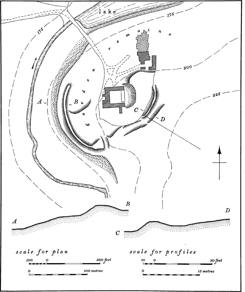
Fig. 48 Fineshade (3) Castle and priory
The major monument is Fotheringhay Castle (34), the scene of many momentous events in English history; it is now reduced to little more than an earthen motte and bailey. The remains of the late medieval college, attached to the church, are of some interest.

Fig. 49 Fotheringhay (34) Castle and (36 and 37) deer parks
Prehistoric and Roman
c(1–15) Fotheringhay Lodge complex (Fig. 50; Plate 3) lies in the N.E. of the parish on gravel and limestone, along the edge of the flood-plain of the R. Nene, at about 50 ft. above OD. The major part of the site consists of a Roman 'village' (13), with a main 'street' or trackway running through it. Most of this settlement lies in Nassington parish but it is described here for convenience. To the S.E. of the settlement is a villa (12), with which it is presumably associated. In addition there are a number of ring ditches (1–8), most of which are probably the remains of round barrows although some may be hut-circles. Those that lie within Nassington are listed under that parish (Nassington (1–14)). Other finds of the prehistoric and Roman periods have also been made in the area (15). (Air photographs in NMR; CUAP, ADR30–34, AVD52–54, ZF39–48)
c(1) Ring ditch (TL 08109494), diam. 25 m., with a small circular, eccentric ditch within it. (BNFAS, 6 (1971), 11, Fotheringhay (1))
c(2) Ring ditch (TL 07729471), diam. 10 m., with a linear ditch extending W. from it.
c(3) Ring ditch (TL 07519425), diam. 30 m., in which are two eccentric pits, one extremely large. In the same field three barbed-and-tanged arrowheads and some flint scrapers have been found (inf. J. A. Hadman; BNFAS, 4 (1970), 31; 5 (1971), 3).
c(4) Ring ditch (TL 07499419), diam. 16 m.
c(5) Ring ditch and enclosure (TL 07559419). The ring ditch has a diam. of 33 m. with a small circular ditch within it on the W. side. It is intersected by a larger egg-shaped enclosure.
c(6) Ring ditch (TL 07489396), diam. 36 m.
c(7) Ring ditch (TL 07559395), diam. 17 m.
c(8) Double ring ditch (TL 07509390) consists of two concentric circles of 20 m. and 33 m. diams. A well-marked central pit is visible. The ring ditch lies immediately inside an oblong enclosure with rounded corners having a large gap on the S. side.
c(9) Bronze Age burials (TL 08009476), discovered in an old quarry. In 1888 a 'Food Vessel' was 'found between the skulls of two skeletons'. The pot, now in BM, was in fact a Beaker (see also (15) for Roman finds and other burials from the same site). (VCH Hunts., I (1926), 216; Arch. J., CX (1953), 177–8)
c(10) Pit alignment (TL 08019520–07929443) runs for almost 1 km. along the E. of the complex in both Fotheringhay and Nassington parishes, roughly parallel to the R. Nene. Its form is sinuous and although there is a gap near the S. end, caused by quarrying and a modern drainage ditch, it is likely to have once been continuous.
c(11) Pit alignment (TL 07669465–07759468), traceable for only 65 m. It meets a linear ditch at its W. end.
c(12) Roman villa (TL 079944), just above the R. Nene flood-plain at 50 ft. above OD. Air photographs show a rectangular building, 36 m. by 13 m., orientated E.-W. with traces of internal walls. Further S. is another similar building and to the W. a large rectangular enclosure. On the ground both buildings are marked by dense patches of limestone and similar areas nearby indicate the existence of further buildings. Finds include roof tiles, tesserae, pottery including samian, and glass. A small trial excavation on the main building in 1970 revealed a stone floor (BNFAS, 5 (1971), 17–18; inf. J. A. Hadman).
c(13) Roman Settlement (TL 07559549–07759449), to the N.E. of (12) on the crest of a gravel ridge about 50 ft. above OD. In spite of frequent air photography over many years, only part of the site is ever visible from the air, and it probably extends on either side of the crest. The most prominent feature of the site is a long ditched trackway, running N.-S. with enclosures or paddocks on either side; many of these are not completely visible on air photographs. In the N. half, in Nassington parish, a number of ring ditches appear to lie under the settlement (Nassington (1–14)); at least one may be a hut-circle. Roman pottery has been found in small quantities over the whole area. The trackway is again visible further S. (at TL 07659405), N.E. of (7), for a short distance, and what may be a continuation of it is also traceable 1.5 km. to the S. (31).
c(14) Roman building (TL 07489524), S.W. of (11) between it and Lyveden Farm, 75 ft. above OD. Air photographs show a rectangular stone structure, orientated roughly E.-W. No interior features are visible. Roman pottery has been found in the area (BNFAS, 8 (1973), 8).
c(15) Iron Age and Roman burials and finds (TL 08009476), found in an old quarry after the discovery of (9) above. Pottery of Iron Age and Roman dates was discovered here as well as Roman coins, a bronze ring, two bronze mounts and two iron knives. Many of these finds are now in Taunton Castle Museum. All were apparently associated with 20 contracted skeletons. (R. F. Whistler, History of Elton (1892), 63–4; VCH Northants., I (1902), 217; Procs. Som. A.S., LII (1906), 69; LVI (1910), 94–5; LVIII (1912), 109)
c (16–20) Walcot Lodge complex (Fig. 51) comprises four ring ditches and a small undated enclosure. It lies in the N.W. of the parish on gravel edging the Willow Brook at about 75 ft. above OD. (CUAP, AFO16, UD46; air photographs in NMR).

Fig. 50 Fotheringhay (1–15) and Nassington (1–15) Fotheringhay Lodge Complex

Fig. 51 Fotheringhay (16–20) Walcot Lodge Complex
c(16) Ring ditch (TL 05229380), diam. 28 m.
c(17) Ring ditch (TL 05289390), diam. 15 m.
c(18) Ring ditch (TL 05449384), diam. 12 m.
c(19) Ring ditch (TL 05499372), diam. 15 m.
c(20) Settlement (TL 05529400) consists of a sub-rectangular ditched enclosure with a smaller enclosure inside. The latter has two other rectangular features within and intersecting it.
b(21–25) Stone Pit Lodge complex (Fig. 53) consists of a large area of crop and soil-marks partly in the S.W. corner of the parish, but extending into Southwick and Woodnewton parishes (see Southwick (1–9)): only those monuments wholly or partly in Fotheringhay are here described. They lie mainly on limestone at 65 ft. above OD on the N. side of a small brook. (CUAP, ABV73, AOK69, WO3, ZF26; air photographs in NMR)
b(21) Ring ditch (TL 04609288), 400 m. N. of Perio Mill. Diam. 10 m.
b(22) Ring ditch (TL 04479279), 150 m. S.W. of (21). Diam. 20 m.
b(23) Settlement (TL 047928), immediately E. of (21). It consists of a large sub-rectangular enclosure with a number of ditches and other features attached to or intersecting it. These include at least six circular ditches some of which may be barrows, but two at least are probably hut circles. Modern drainage ditches have confirmed the crop-marks, and one sherd of black calcite-gritted pottery as well as a large block of limestone with 'cup-marks' on one face (Plate 24) have been found (BNFAS, 6 (1971), 11; 8 (1973), 4). A scatter of 3rd and 4th century pottery was also found (BNFAS, 8 (1973), 6).
b(24) Enclosure (?) (TL 04489319), 250 m. N.W. of (23). Indeterminate ditches, visible on air photographs, suggest one or more enclosures.
b(25) Ditched trackway (?) (TL 04009323–04609276) runs along the N. side of a small brook in Fotheringhay and Woodnewton parishes; it is traceable for 800 m. as two parallel ditches 15 m. apart and is intersected by linear ditches which may be part of the settlement (23). Near its centre, in Woodnewton parish, a small sub-rectangular enclosure lies immediately N. of it. If it is a trackway it may have once been connected with the large settlement area to the S.W. (Southwick (6)), S. of Stone Pit Lodge. Evidence for a bridge across the R. Nene, beyond its S.E. end (Southwick (7)), may indicate its further extension in this direction (BNFAS, 6 (1971), 11, pl. 13 (1)).
b(26–28) Willow Brook complex (Fig. 52) consists of a group of features, visible only on air photographs, on the N. of the Willow Brook, on gravel at 75 ft. above OD in the N.W. of the parish (CUAP, ABV76, AFO10).
b(26) Ring ditch (TL 04919422), diam. 20 m.
b(27) Ring ditch (TL 04829418), diam. 20 m., intersected by a short length of ditch.
b(28) Enclosures and linear ditch (TL 047942) consist of at least two conjoined rectangular enclosures associated with pits and ditches, which are crossed by a long linear ditch running E.-W. traceable for some 520 m. (BNFAS, 6 (1971), 11, pl. 10 (2))
b(29) Ring ditch (TL 04869345), on gravel, at 100 ft. above OD. Diam. 20 m., with a well-marked central pit or grave (air photographs in NMR).

Fig. 52 Fotheringhay (26–28) Willow Brook Complex

Fig. 53 Fotheringhay (21–25) Southwick (1–9) Stone Pit Lodge Complex
c(30) Bronze Age burial (unlocated but perhaps from gravel pit at TL 07089381). Found in the late 19th century. A very small pot with herringbone decoration was discovered and is probably that illustrated by Abercromby and now in Northampton Museum (Plate 22). A paleolithic implement was found in the underlying gravel. (VCH Northants., I (1902), 136, 143; J. Abercromby, Bronze Age Pottery II (1912), No. 275, pl. LXXXI; see also Arch. J., CX (1953), 176).
c(31) Ditched trackway (TL 07389252–07339226), in the S.E. of the parish, close to the R. Nene on gravel at 15ft. above OD. It consists of two parallel ditches 20 m. apart running in a N.N.E.-S.S.W. direction and traceable for nearly 300 m. It may be connected with the trackway in the Roman settlement (13) 1½ km. to the N. and perhaps passed through the Roman settlement (33). (Air photographs in NMR)
c(32) Enclosure (?) (TL 066931; Fig. 13) lies 400 m. N.E. of the castle on a small patch of gravel within an area of alluvium, at 40 ft. above OD. Air photographs (in NMR) show a three-sided ditched enclosure, with a length of ditch and a small rectangular feature attached to its N.W. side.
(33) Roman settlement (?) (TL 073930) lies on the edge of the R. Nene flood-plain on gravel at 50 ft. above OD. A scatter of late 3rd and early 4th-century pottery has been found (BNFAS, 5 (1971), 17), as well as tiles and limestone rubble.
Medieval and Later
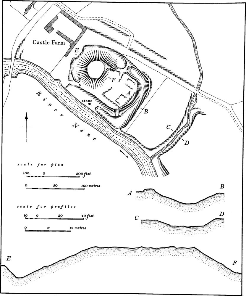
Fig. 54 Fotheringhay (34) Castle
c(34) Fotheringhay Castle (TL 062929; Figs. 49, 54 and 55; Plate 5) lies at the S.E. end of the village, adjacent to the R. Nene, on gravel at 50 ft. above OD. It was probably built by Simon de St. Liz, Earl of Huntingdon and Northampton, who married the daughter of Judith, Countess of Huntingdon and niece of the Conqueror. The present motte and inner bailey or court are probably his work. It does not appear to have been important as a military stronghold, and from the late 13th century it took on the dual role of royal palace and State prison. It was apparently considerably rebuilt and enlarged in the late 14th century by Edmund Langley, son of Edward III, and the outer bailey or court may date from this period, as perhaps does the infilling of the motte ditch on the E. side. Other alterations and additions were made in the 15th century but these do not now survive. The castle was abandoned in the 17th century and a gradual process of demolition of all its walls and buildings was largely completed by the early 18th century. The few remaining building fragments still standing by the late 19th century were incorporated into the barns of the present Castle Farm by Lord Overstone who also filled in the former moat on the W. side of the site. There are a number of descriptions of the castle at various dates. The most complete is that of 1341 before it was enlarged, and this seems to indicate that only the motte, then with a stone tower, and the present inner bailey existed. Within the bailey were two chapels, a great hall, chambers and the kitchen, together with a gatehouse over a drawbridge. However there is mention of another group of buildings outside the castle, then called The Manor. These probably lay N.W. of the motte on the site of Castle Farm. A later account, dating from just before Mary Queen of Scots was sent to Fotheringhay in 1586, notes the existence of the outer moat and two separate gates. The last detailed description was made in 1625 just before demolition started, and is clear enough to enable a conjectural reconstruction to be made of the castle's lay-out at that time (Fig. 55). The castle was then said to be

Fig. 55 Fotheringhay (34) Castle in 1625, conjectural reconstruction
'. . . . very strong, built of stone, and moated about with a double moat. The R. Nen on the S. side serves for the outer moat, and the Mill-brook on the E. side between the little park and the Castle-yard, called the old orchard or garden, serves for the outer moat on that side; between which mill-brook and the Castle there has been a great pond, landed up, on the E. side of the Castle. The gate and forepart of the house fronts the N., and as soon as you are passed the drawbridge, at the gate there is a pair of stairs, leading up to some fair lodgings and up higher to the wardrobe, and so on to the fetterlock on top of the mound on the N.W. corner of the castle, which is built round of 8 or 16 square with chambers lower and upper ones roundabout, but somewhat decayed and so are the leads on the top; in the very midst of the round yard in the same there has been a well, now landed up. When you come down again and go towards the hall, which is wonderful spacious, there is a goodly and fair court, within the midst of the castle. Of the left-hand is the chapel, goodly lodgings, the great dining-room, and a large room at this present well garnished with pictures. Near the hall is the buttery and kitchen; and at the other end of the kitchen a yard, convenient for wood and such purposes, with large brewhouses and bake-houses and houses convenient for offices. From the gate going out of that yard, there is another yard half-encompassing the castle, going roundabout to the first gate and a great barn in the W. side of the said yard. A gate-house and another ruinous house in the E. corner of the same.' (H. K. Bonney, Fotheringhay, (1821), 29–30)
The remains of the original motte and bailey are now in good condition but the moated outer court or bailey has been greatly mutilated. The motte is now a steep-sided mound, 7 m. high and up to 70 m. in diam., rising to a flat top, 30 m. across. The summit is very irregular, probably due to a combination of stone robbings and later excavations. The motte is bounded on two sides by a wide ditch, up to 4 m. deep, now partly filled in on the W. It probably once encircled the motte. The ditch now runs S.E. from the motte, and is partly filled in to make a modern entrance which is probably the site of the original one; it continues S.E. and then swings S.W. to meet the R. Nene and so encloses the inner bailey or court. Here it is up to 2 m. deep, with traces of an inner rampart. The junction of the ditch with the river is now blocked by a low bank but, in times of flood, water from the Nene still partly fills the ditch. Parallel to the river on the S. side of the bailey is a well-marked scarp 1 m.-3 m. high. Below it, close to the river, is a large block of limestone rubble, with a small area of squared ashlar on the S. side. This is said to have come from the summit of the motte and was set up here in 1913.
The inner motte and bailey were originally surrounded by an outer moat on three sides. To the S.E. this survives as a deeply-cut ditch up to 2.5 m. deep, through which a stream still runs. At its N. end the modern track crosses the stream on a bridge, the limestone ashlar abutments of which retain the slots for a sluice. This sluice probably held the water in the 'great pond' described in the 1625 survey, and is also the site of the eastern gatehouse. N.W. of the sluice the outer bailey ditch is traceable as a broad shallow depression as far as the N. side of Castle Farm. It originally appears to have continued N. as far as the present farm entrance and then turned S.W. in front of the farm to reach the river. No trace remains there now except for part of a shallow depression close to the river. (VCH Northants., II (1906), 570–4; H. K. Bonney, Fotheringhay, (1821), 18–33; P. M. G. Dickinson, Historic Fotheringhay (1956))
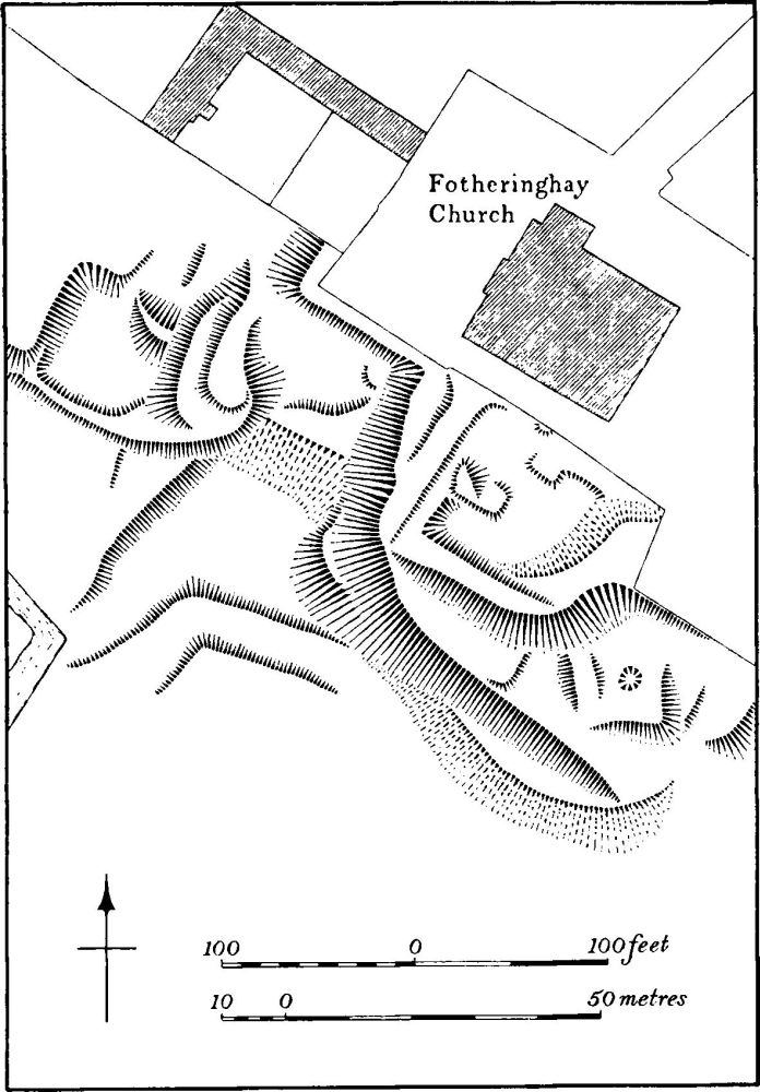
Fig. 56 Fotheringhay (35) Site of college
c(35) Fotheringhay College (TL 05919311; Fig. 56) lies immediately S. of the church on a series of partly natural and partly artificial terraces above the R. Nene. The college was founded in 1411 by Edward of York, carrying out the wishes of his father Edmund Langley, Duke of York, who had already built a chancel, now demolished, onto the end of the existing medieval church. Work on rebuilding this church and erecting the conventual buildings began in 1415, but was cut short by Edward's death in the same year. Work was restarted in 1432, by which time the conventual buildings seemed to have existed. The contract for the church was made in 1434, but buildings were still incomplete in 1460 when Edward IV granted a new charter and refounded the college.
The college consisted of a master, 12 chaplains or fellows, 8 clerks and 13 choristers. It was dissolved in 1539, and later the buildings were granted to Dudley, Duke of Northumberland. He pulled down the chancel of the church, leaving the nave as the parish church, and removed the roofs of the college buildings (VCH Northants., II (1906), 170–7). A detailed description of the college buildings as they were in 1550 survives (BM Harl. MS. 608, f. 61v, 62–62v). Among the places mentioned are 'the cloister', with at least nine chambers around it, 'a house called The Vestry', with a chamber over, a library, a hall, kitchens, lodgings, wood-yard, courts, brew-house, stables, barns, etc. Shortly afterwards all these buildings were pulled down (Arch. J., LXI (1904), 241–75).
The remains of the college buildings are in poor condition and provide little indication of the original plan. Immediately S. of the church is a large sub-rectangular platform, some 2.5 m. above the river terrace to the S., which is likely to be the site of the cloisters, and traces of wall footings of a long range of buildings exist on the W. side. The rest of the platform is uneven and much disturbed. To the W. are some small platforms and scarps, but these form no coherent pattern. Excavations on the site in 1926 by Oundle School are alleged to have discovered wall foundations, stained glass, glazed tiles and other material, but no report was written.
ac(36) Deer park (centred TL 062944; Figs. 49 and 57) occupied much of the N.E. part of the parish and covered about 120 hectares on limestone and clay. It was probably constructed in 1230 when John, Earl of Huntingdon, was given permission to make deer leaps in the parish; twice in the following years he was granted deer from Rockingham Forest with which to stock his park. It was probably disparked in the 17th century. (VCH Northants., II (1906), 570 and 572; PN Northants., 202)
The W. and N. boundaries of the park are still traceable within the narrow strip of woodland known as Park Spinney (TL 05509422–06869499). Here a large bank, some 5 m. wide and up to 1.5 m. high, is almost continuous; in places smaller, and presumably later, copse banks run parallel to it. The remains on the E. side are less complete. Only a degraded bank, 1 m. high, exists on the W. side of the Nassington Road, S.E. of Park Lodge, for a distance of some 580 m. (TL 06489380– 06769430). However, this shortage of remains is the result of realignment of Nassington Road in two places, probably in the 18th or 19th centuries. A map of c. 1716 (NRO) shows the road in its earlier position and this must indicate the original park boundary. Either the old road or the park pale shows as a cropmark on air photographs (held by Monk's Wood Research Station, Huntingdon). There is no trace of a S.W. boundary to the park along the two modern stream courses, but the park was doubtless bounded by one of them. The 1716 map also gives a number of significant field names within the area of the park. The fields S. of Park Lodge have extensive remains of ridge-and-furrow (see (40)) the date of which is not known.
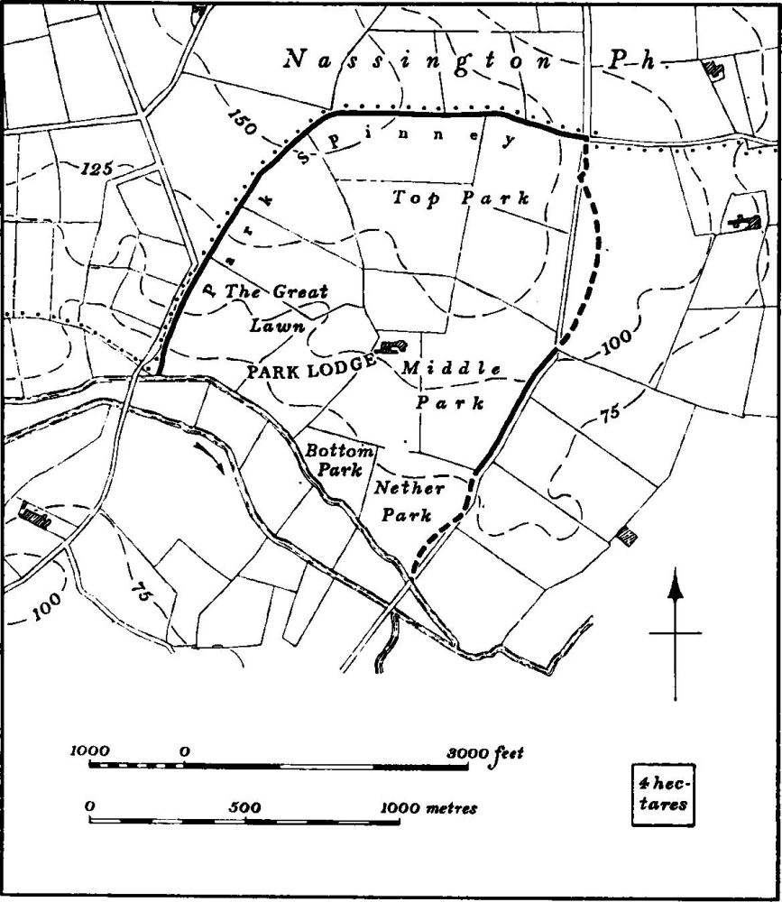
Fig. 57 Fotheringhay (36) Deer park
c(37) Deer park (centred TL 065926; Fig. 49), immediately S.E. of the castle, on land around a small limestone hill. The earliest known document is of the 16th century when it was called the Little Park, but it may be of late medieval date (VCH Northants., II (1906), 572). Its area is unknown, but the long narrow field, called The Park on a map of c. 1716 (NRO), only covers some 12 hectares and the original park was probably not much larger. The only surviving boundary is a length of low bank, 0.5 m. high and 1.5 m. wide, with a slight external ditch running N.W.-S.E. along the crest of the hill above the R. Nene (TL 06359265).
c(38) Settlement remains (TL 058933), formerly part of Fotheringhay village, lie N. of the main street and N.W. of the church, and although now largely destroyed, consist of a broad hollow-way running parallel to the village street for a distance of 300 m. At its E. end it forms a T-junction with another hollow-way running N.N.E. from the village street to the edge of a brook, 300 m. away. Low banks and scarps to the N. of the former hollow-way, and various indeterminate earthworks elsewhere, perhaps indicate former house sites. The hollow-ways were apparently still in use in the early 18th century (NRO, map of about 1716) but no buildings then existed.
c(39) Pillow mound (TL 05529318; Fig. 58; Plate 19), immediately W. of the village just below the crest of a low rounded hill overlooking the R. Nene, on limestone, at 75 ft. above OD. The long rectangular, flat-topped mound lies within an area of ridge-and-furrow with which it is probably contemporary. At the S. end the ploughing of the adjacent ridge has broken down the outer lip of the surrounding ditch. (BNFAS, 8 (1973), 27)
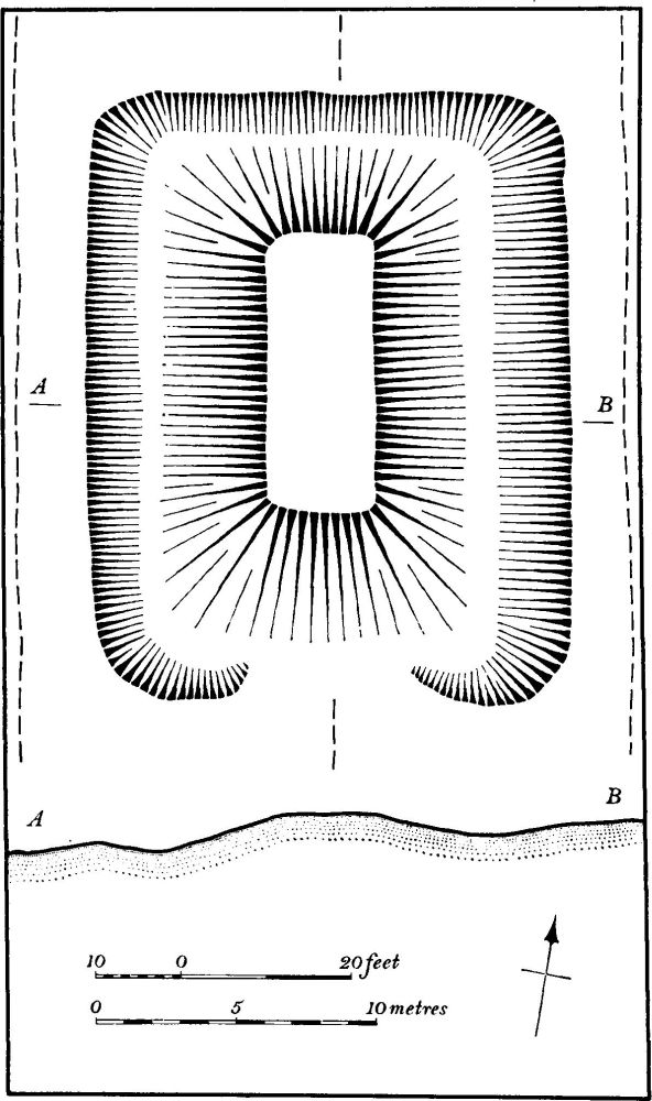
Fig. 58 Fotheringhay (39) Pillow mound
(40) Cultivation remains. The common fields of the parish were enclosed in 1635 (J. Bridges, Hist. of Northants., II (1791), 456). Ridge-and-furrow of these fields remains on the ground, or can be traced on air photographs, in a number of places, particularly along the edge of the flood-plain of the R. Nene in the E. of the parish and also W. of the village. It is also traceable along the banks of the Willow Brook, N.W. of the village. In these areas it is lying almost at right angles to the main watercourses. In a few other places are small areas of ridge-and-furrow arranged in interlocked furlongs, e.g. N.E. of Garden Farm (TL 072938) and E. of the castle (TL 066928). S. and S.E. of Park Lodge (TL 063941), within the medieval deer park (36), is a further area of ridge-and-furrow arranged in interlocked furlongs. (RAF VAP CPE/UK 1891, 2206–13; 1925, 1107–18; 2109, 3085–94, 4084–94, 4224–34)