An Inventory of the Historical Monuments in the County of Northamptonshire, Volume 2, Archaeological Sites in Central Northamptonshire. Originally published by Her Majesty's Stationery Office, London, 1979.
This free content was digitised by double rekeying. All rights reserved.
'Moulton', in An Inventory of the Historical Monuments in the County of Northamptonshire, Volume 2, Archaeological Sites in Central Northamptonshire(London, 1979), British History Online https://www.british-history.ac.uk/rchme/northants/vol2/pp110-112 [accessed 30 April 2025].
'Moulton', in An Inventory of the Historical Monuments in the County of Northamptonshire, Volume 2, Archaeological Sites in Central Northamptonshire(London, 1979), British History Online, accessed April 30, 2025, https://www.british-history.ac.uk/rchme/northants/vol2/pp110-112.
"Moulton". An Inventory of the Historical Monuments in the County of Northamptonshire, Volume 2, Archaeological Sites in Central Northamptonshire. (London, 1979), British History Online. Web. 30 April 2025. https://www.british-history.ac.uk/rchme/northants/vol2/pp110-112.
In this section
42 MOULTON
(OS 1:10000 SP 76 NE)
The parish covers some 1200 hectares immediately N. of Northampton to which it has recently lost some land. The N. boundary of the parish was formerly the W.flowing Holcot Brook, the valley of which is now occupied by the Pitsford Reservoir. From the reservoir the land rises across outcrops of sands, silts and lime-stones to a Boulder Clay ridge, running E.–W., at just over 122 m. above OD. Further S. the land falls towards the valley of the Moulton Brook, where Northampton Sand is exposed. In the extreme S. of the parish the land rises again to around 107 m. above OD, and is largely covered by Boulder Clay and glacial sands. All the prehistoric and Roman sites in the parish have been discovered by air photography and the fact that their distribution is entirely on Northampton Sand is probably a reflection of the capacity of those soils to produce cropmarks.
Prehistoric and Roman
Two flint arrowheads and a scraper have been found in the village (NM Records). A few Roman sherds have been found in the N. of the parish along the edge of Pitsford Reservoir (at SP 771693; Northants. Archaeol., 9 (1974), 91) and further S. (at SP 775682 and 772678; BNFAS, 4(1970), 11, 19).
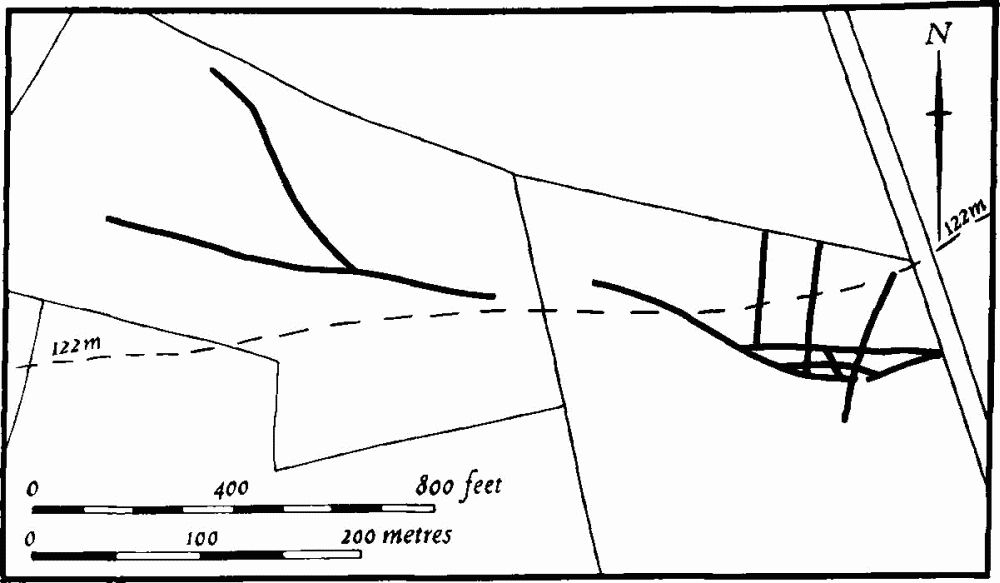
Fig. 102 Moulton (2) Cropmarks
(1) Enclosure (SP 778690; Fig. 104), in the N. of the parish on the edge of Pitsford Reservoir, on sand and clay at 95 m. above OD. Air photographs (in NMR) show a rectangular enclosure with traces of ditches, perhaps parts of further enclosures to the N., N.W., and S. (BNFAS, 6 (1971), 16, Moulton (1)).
(2) Ditches (SP 768678–772677; Fig. 102), N.W. of Moulton Lodge, on limestone and Boulder Clay at 122 m. above OD. Air photographs (in NMR) show a series of linear ditches with, at their E. end, a complex pattern of intersecting enclosures or short lengths of ditch. The same air photographs also indicate other marks of linear form which are probably modern (not shown on Fig. 102).
(3) Enclosures (SP 789669; Fig. 103), N.E. of the village, on sand at 100 m. above OD. Air photographs (in. NMR) show what appears to be a series of overlapping enclosures, though only one is complete (BNFAS, 6 (1971), 16, Moulton (2)).
(4) Ring Ditches and Enclosures (SP 781667; Fig. 104), N. of the village, on sand at 99 m. above OD. Air photographs (in NMR) show, very indistinctly, at least three ring ditches and a small double enclosure (BNFAS, 6 (1971), 16, Moulton (3)).
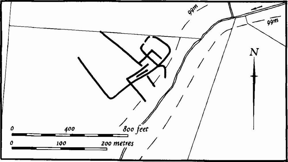
Fig. 103 Moulton (3) Cropmarks
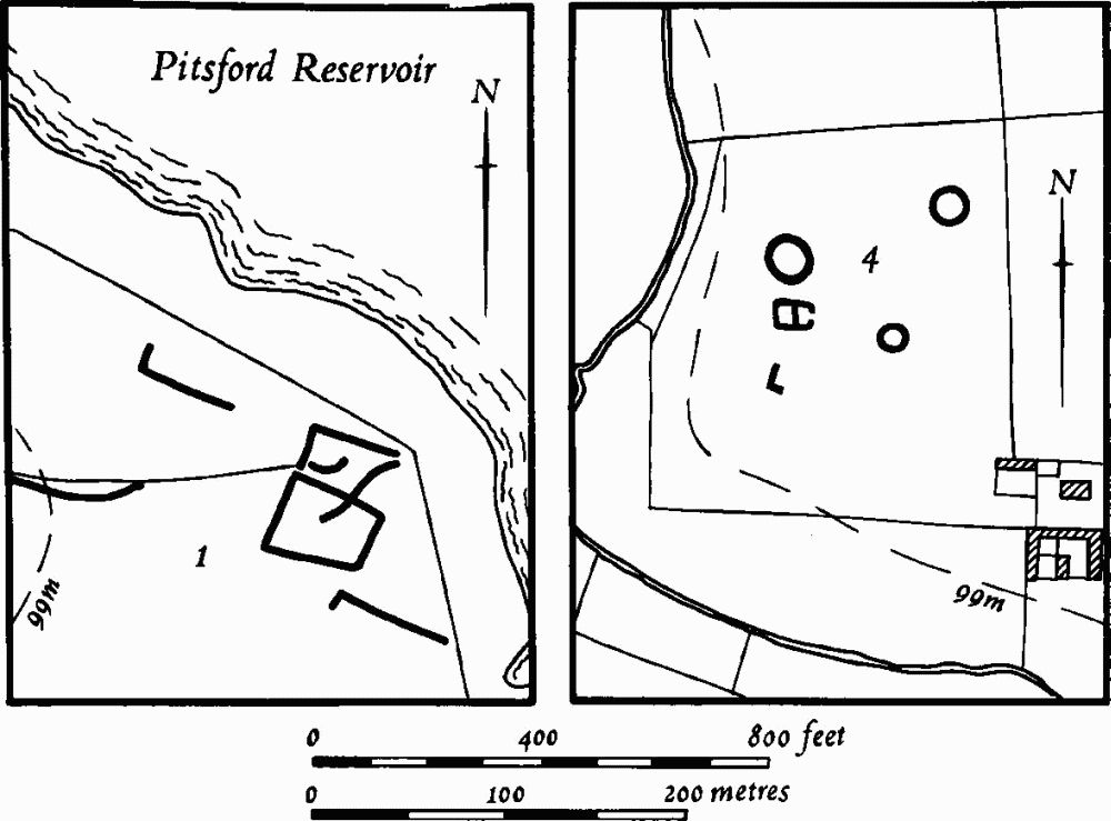
Fig. 104 Moulton (1, 4) Cropmarks
(5) Roman Settlement (SP 775668; Fig. 105), N.W. of the village, on sand at 100 m. above OD. Air photographs (in NMR) show a series of conjoined rectangular enclosures, some with interior features and one with a large number of pits. Interpretation is difficult owing to extensive frost-wedging in the area. Some sherds of Roman pottery were found on the site in 1967 (BNFAS, 6 (1971), 16, Moulton (5)).
(6) Ring Ditches, Pit Alignment and Roman Settlement (SP 768667; Fig. 105), in the N. of the parish, close to the Pitsford boundary, on sand at 97 m. above OD. Air photographs (in NMR) show two overlapping ring ditches associated with a series of incomplete enclosures and ditches. Further N. other ditches intersect a E.—W. pit alignment. Finds from the area include numerous worked flints, four barbed-and-tanged and six leaf-shaped arrowheads and sixteen scrapers, quantities of Roman pottery from the mid 2nd to 4th centuries, samian ware, roof tiles, quern stones and Roman coins. Much medieval pottery is also recorded (BNFAS, 4 (1970), 11; 5 (1971), 4; 6 (1971), 16, Moulton (4)). Another Roman coin is reported as having been found a little to the E. (OS Record Cards).
Medieval and Later
Scatters of medieval pottery, probably of little signicance, have been found at a number of places in the parish, in addition to that at (6) above (BNFAS, 4 (1970), 19; 5 (1971), 30).
(7) Occupation Site (SP 784663), immediately S.E. of the church. Building work in 1968 revealed drystone-walling and a few sherds of medieval pottery. Part of a plain Saxon vessel was also found (BNFAS, 3 (1969), 26).
(8) Occupation Site (SP 782686), immediately E. of the North Farm in the N. of the parish. Large quantities of 13th-century pottery, associated with a scatter of stones, were discovered in 1969 (BNFAS, 4 (1970), 19).
(9) Manor House Site (?) (SP 78606715), 1 km. N.E. of the church on the N. side of a valley, on clay at 114 m. above OD. The area is traditionally known as Castle Hill and is said to be the site of the manor house of the Fitz John family who are known to have held land in Moulton in the 13th century (VCH Northants., IV (1937), 88–90). Bridges writing in c. 1720, said that foundations of buildings had been dug up and that there were traces of a moat (J. Bridges, Hist. of Northants., I (1791), 419).

Fig. 105 Moulton (5) Roman settlement, (6) Cropmarks and Roman settlement
The remains lie on a small, natural, almost circular knoll. On air photographs taken in 1946 (RAF VAP 3G/TUD/UK 118, 6224–5) most of the knoll was already under cultivation and only a wedge-shaped area of land remained intact. Within this, standing on the summit, was a V-shaped bank with its apex to the N., with a large depression or pit to the S. and what appear to have been rectangular platforms below it. These have been totally destroyed by modern ploughing and only the depression, 25 m.–30 m. across and up to 2 m. deep, survives. The surrounding area is very stony and there are patches of dark earth. A few sherds of medieval pottery have been discovered there.
(10) Dam (SP 78386652), spans the bottom of a steep-sided valley cut into Upper Lias Clay, on the N. side of the village between the church and Manor Farm, at 94 m. above OD. The modern drive to Manor Farm runs along the top of a large earthen bank 15 m. wide and up to 2 m. high, apparently a former dam which once ponded water behind it to the E. If this is so it may be one of the 'large ponds . . . still remaining' near the old Manor House to which Bridges referred in about 1720 (J. Bridges, Hist. of Northants., I (1791), 419).
(11) Cultivation Remains. At least part of the common fields of the parish were enclosed by Act of Parliament of 1772 (VCH Northants., IV (1937), 88; NRO, Enclosure Award). The small areas of ridge-and-furrow of these fields which can be traced on the ground or from air photographs are arranged in end-on and interlocked furlongs. Only three such areas survive. These are immediately S. of the village (SP 787658), on the E. boundary of the parish (centred SP 788683), and to the W. of that (centred SP 776682; RAF VAP F21 543/RAF/2409, 0123–4; F21 540/RAF/1312, 0237–8; F22 540/RAF/1312, 0234–9; F22 542/RAF/97, 0025– 6; CPE/UK/1925, 1369–75, 4224–7; 3G TUD/UK/118, 6222–6, 6184–7).