An Inventory of the Historical Monuments in the County of Northamptonshire, Volume 2, Archaeological Sites in Central Northamptonshire. Originally published by Her Majesty's Stationery Office, London, 1979.
This free content was digitised by double rekeying. All rights reserved.
'Orlingbury', in An Inventory of the Historical Monuments in the County of Northamptonshire, Volume 2, Archaeological Sites in Central Northamptonshire(London, 1979), British History Online https://www.british-history.ac.uk/rchme/northants/vol2/pp116-120 [accessed 30 April 2025].
'Orlingbury', in An Inventory of the Historical Monuments in the County of Northamptonshire, Volume 2, Archaeological Sites in Central Northamptonshire(London, 1979), British History Online, accessed April 30, 2025, https://www.british-history.ac.uk/rchme/northants/vol2/pp116-120.
"Orlingbury". An Inventory of the Historical Monuments in the County of Northamptonshire, Volume 2, Archaeological Sites in Central Northamptonshire. (London, 1979), British History Online. Web. 30 April 2025. https://www.british-history.ac.uk/rchme/northants/vol2/pp116-120.
In this section
45 ORLINGBURY
(OS 1:10000 a SP 87 SW, b SP 87 SE)
The parish is roughly rectangular and covers nearly 775 hectares, between two E.-flowing tributaries of the R. Ise. The higher land in the W. between 107 m. and 137 m. above OD, and the central ridge which runs E.—W., are covered by Boulder Clay, but the down-cutting of the two streams to the N. and S. has exposed bands of Great Oolite Limestone, clays, silts and limestones of the Estuarine Series, Northampton Sand and Upper Lias Clay. Much of the parish is covered by Boulder Clay but the known settlements, both Roman (2), (3) and (4), and medieval (5) and (6), are situated on limestone or close to the areas of sedimentary deposits. The major monument is the deserted village of Wythmail (5). The earthworks of this village, like those of another medieval settlement, Badsaddle (6), are now almost entirely destroyed.

Fig. 109 Old (3) and Walgrave (12) Cultivation remains
Prehistoric and Roman
Two 'tumuli' are shown on a map of 'Bannaventa and its environs', at approximately SP 859722 and SP 861722 (Archaeologia, 35 (1853), 394, pl. 26). No trace of these exists on the ground or on air photographs.
a(1) Enclosures (SP 841714), in the S.W. of the parish on the N. side of a small valley, on Boulder Clay at 115 m. above OD. Air photographs taken in 1970 (not seen by RCHM) are said to show some circular and sub-rectangular enclosures in this area (BNFAS, 5 (1971), 42).
b(2) Roman Building (?) (SP 857715), S.W. of the village on sand at 95 m. above OD. Cropmarks of a nearly circular structure and a rectangular building with three rooms are said to have been seen here (NM Records).
b(3) Roman Settlement (SP 862728), N. of the village, on limestone at 100 m. above OD. An extensive scatter of stone was found here in 1968, with Roman pottery and pieces of roofing tile (BNFAS, 3 (1969), 16). Two small black Roman urns, said to have been found in Orlingbury and now in NM, may have come from this site or (4) (VCH Northants., I (1902), 219).
ab(4) Roman Settlement (SP 850728), N.W. of the village on the side of a small valley, on limestone at 94 m. above OD. Building stone, roof tiles and a large amount of Roman pottery were found here in 1967 (BNFAS, 2 (1967), 14).
Medieval and Later
a(5) Deserted Village of Wythmail (SP 842721; Fig. 110; Plate 15), lies in the W. of the parish, on limestone, sands and Boulder Clay at around 122 m. above OD.
The village was first recorded in Domesday Book, when it was assessed for 2½ hides, with a recorded population of 17 and a priest (VCH Northants., I (1902), 340). However, part of this manor certainly lay in Orlingbury and the priest may have been associated with that village. In addition the now deserted settlement of Badsaddle (6) was probably also included in the Domesday record. In 1220 the village was rated at six ploughs, and it was mentioned in the Nomina Villarum of 1316. A manorial chapel was referred to in 1357. The village was assessed jointly with Orlingbury in the 1334 Subsidy Returns and in the 1377 Poll Tax. In 1614 the site of the village was made into a park which existed until 1657. By 1720 there was nothing but a 'lone house'. In 1754 (Map of Wythmail, NRO) the site of the village lay in a field called Park Close (VCH Northants., IV (1937), 205–7; K.J. Allison et. al., The Deserted Villages of Northamptonshire, (1966), 48; J. Bridges, Hist. of Northants., II (1791), 121; RAF VAP CPE/UK/1925, 2233–5, 3359–61; CUAP, AKP 78, AWU 101, SD 90, VR 18, YX 91; air photographs in NMR).
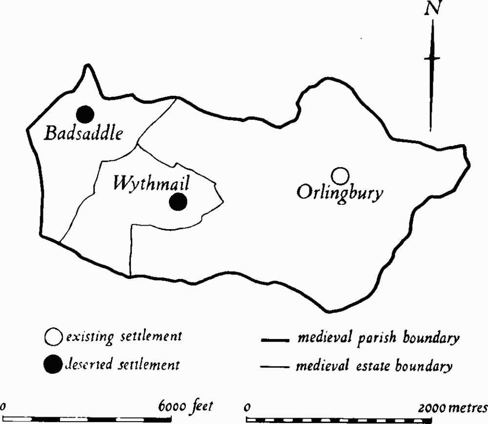
Fig. 110 Orlingbury Medieval settlements and estates
The remains of Wythmail have been completely destroyed by modern ploughing and only air photographs taken in 1947 show the former appearance of the earthworks (Plate 15). At that time the area of the village was clearly defined by existing hedges or low banks and ditches separating it from the adjacent ridgeand-furrow. A deeply cut hollow-way entered the site from the N. and passed through the E. part in a broad curve towards the existing farm. Near its centre another hollow-way running E.—W. crossed it at right-angles. Further W. there were other more indeterminate hollowways, forming no coherent pattern. Alongside all these hollow-ways traces of embanked closes and house platforms, as well as large depressions, were visible.
In 1954 one single toft was excavated by DOE. This revealed occupation of three different periods: Period I (early 13th century), a series of post-holes, probably of a timber building, bounded on the N. by a small ditch; Period II (late 13th century), a stone long-house, comprising a main room with a central hearth, separated by a paved cross-passage from a byre; Period III (14th century) a stone long-house, set at right-angles to the earlier building, consisting of four rooms, two with hearths, and two used for animals or other agricultural purposes. S. of this main living-area was a sequence of six structures, two of which may have been ovens, and one a byre. In Period II three of these buildings were associated with the long-house, but in Period III a road which was driven across the site separated them from the long-house and they were abandoned (Med. Arch., 13 (1969), 167–203). Almost nothing is now visible on the ground apart from slight undulations and large quantities of limestone rubble, associated with 13th and 14th-century pottery.
S. and W. of the present farm are the remains of a Moat. This now consists only of a curving ditch 100 m. long and 12 m. wide, but air photographs taken before destruction, and its depiction on the Enclosure Map of Orlingbury (NRO, 1811), suggest that it was originally a circular or oval ditch surrounding an island with a farm house in the centre. To the N. of the moat, between it and the village remains, there appear to have been two rectangular embanked and ditched enclosures separated by a track or hollow-way approaching the moat.
The boundaries of the land which seems to have been associated with Wythmail are recoverable from the 1754 maps (Fig. 110).
a(6) Deserted Settlement of Badsaddle (SP 833730; Fig. 110; Plate 14), lies in the N.W. corner of the parish, around Badsaddle Lodge, on Boulder Clay at 122 m. above OD.
The settlement is not directly mentioned in Domesday Book, but is almost certainly included silently in the 2½ hide manor held by Fulcher Malesoures in Wythmail (5) as both places, as well as Orlingbury, were recorded as being held by him in the later Northamptonshire Survey (VCH Northants., I (1902), 327, 340, 382).
However the Wythmail manor, as listed in Domesday Book, also included part of the Orlingbury and so it is impossible to ascertain the late 11th-century population of either Badsaddle or Wythmail. The 12th-century Northamptonshire Survey records that Badsaddle was then assessed for half a hide, and in 1220 the manor was rated only for two ploughs. Both records indicate that Badsaddle was a very small settlement, and this is supported by the fact that when John Trussell was holding the manor in 1285 it was stated that Badsaddle, Wythmail and Orlingbury ought to be represented as a single vill at the Sherrif's Tourn. However Badsaddle is separately recorded in the Nomina Villarum of 1316.
In 1303 an extent of Badsaddle Manor only lists one capital messuage, one watermill and certain customary work (Cal. IPM. IV (1913), 219). By 1392 the manor consisted of 20 acres of meadow, 200 acres of pasture and 20 acres of wood, but no arable land or tenants are recorded. The land of the manor seems later to have been abandoned, for in 1571, when a law suit over the formation of a deer park took place, it was claimed that 'certain lands called Battsadell in Orlingbury . . . had long been common or pasture'. In 1547 200 sheep were being maintained on the manor. By about 1720 Bridges recorded only 'a lone house . . . formerly surrounded with a moat now filled up'. However, on the Enclosure Map of Orlingbury of 1811 (NRO) part of the moat is shown as an L-shaped pond, still surviving on the W. part of the N. side of Badsaddle Lodge (J. Bridges, Hist of Northants., II (1791), 120; VCH Northants., IV (1937), 204–6; K.J. Allison et al., The Deserted Villages of Northamptonshire, (1966), 35; RAF VAP CPE/UK/ 1925, 2232–3, 3231–2, 3261–2).
The remains of the settlement of Badsaddle have been almost completely obliterated by modern ploughing and only air photographs taken before destruction show the former appearance of the earthworks. These air photo graphs support the evidence from documents that Badsaddle was always very small, and indeed suggest that the settlement perhaps never consisted of more than the present farm and two or three houses.
A hollow-way, visible as an earthwork immediately N. of the farm and as a cropmark elsewhere, crossed the site from E. to W. To the N. of it two separate blocks of ridge-and-furrow extended down the slope to the valley bottom. These were separated by a rectangular embanked enclosure with a large irregular hole in the centre which in 1947 was drained by a modern ditch. S. of the hollow-way and E. of the existing farm there was another larger enclosure with ridge-and-furrow within it. At the W. end of the ridges there were indications of building platforms. These still survive as slightly raised areas covered by stone rubble and small amounts of 13th and 14th-century pottery. To the W. of the house were at least two, or possibly three, ponds of trapezoidal shape, lying in the bottom of a shallow valley. These were fed by a narrow inlet channel running out of the N.W. corner of Badsaddle Wood, and were possibly fishponds or perhaps mill-ponds connected with the mill mentioned in 1303. The farm buildings were surrounded by uneven and ill-defined earthworks which may be the result of the infilling of the moat recorded by Bridges in the early 18th century (CUAP, AWU 104).
b(7) Medieval Finds (SP 860722), W. of the village green. Two rubbish pits containing 13th-century pottery, and other pottery, including St. Neots and Lyveden wares, were found (BNFAS, 2 (1967), 27).
b(8) Hollow-Ways (SP 858720, 862721, 863723), lie in three places around the existing village and radiate from it. They represent the lines of long-abandoned medieval roads which once gave access to the fields of Orlingbury. One, S.W. of the village, passing through ridge-and-furrow, is little more than a shallow depression. Another, S.E. of Orlingbury Hall, is well-marked, up to 1.5 m. deep. The third, N.E. of Home Farm, has recently been destroyed by ploughing.
b(9) Hollow-Way (SP 861721), formerly part of Orlingbury village lies immediately S. of Orlingbury Hall, and within its garden. Before 1811 the road from Little Harrowden S.E. of Orlingbury Hall ran in a direct line from just N. of Roadside Spinney (SP 86187185) to a point due E. of the Hall (SP 86047218). Then during enclosure of the common fields the opportunity was taken to extend the gardens of the Hall to the S.W. by realigning the road to its present position. The work involved the abandonment of the existing road and demolition of two or three houses. Part of the original road is still traceable as a slight hollow-way around the N.E. side of the old kitchen garden (NRO, Enclosure Map, 1811).
(10) Cultivation Remains. The common fields of Orlingbury village were enclosed by Act of Parliament of 1808 (NRO, Enclosure Map, 1811). Immediately before that date there were five open fields, Little, Pytchley, Moor, Middle and Snortwell, arranged around the village. Ridge-and-furrow of these fields exists on the ground or can be traced on air photographs over much of their area, arranged in end-on and interlocked furlongs, mainly of markedly reversed-S form. The exception is in the S. of the parish, in the W. half of the former Snortwell Field, where all the furlongs are end-on, with well-marked headlands still up to 1 m. high between them. Elsewhere a number of other headlands exist as low ridges. One, in the former Middle Field (SP 851720–857724), is 600 m. long, while two others in the former Pytchley Field (SP 858731 and 860728), lying parallel to each other, are 550 and 500 m. long respectively.
The date of the enclosure of the common fields of the deserted village of Wythmail (5), if they ever existed, is unknown. Ridge-and-furrow can be traced on air photographs to the E. of the village site within the land attributable to Wythmail. The fragments which survive appear to be arranged in interlocked furlongs.
Ridge-and-furrow also exists in the N.W. of the parish in an area known as Orlingbury Wolds in 1754 (NRO, Maps of Wythmail). Part at least of this land belonged to the deserted settlement of Badsaddle (6) and the ridgeand-furrow is laid out in interlocked furlongs (RAF VAP CPE/UK/1925, 2230–40, 2353–63, 3231–7, 3355–63; F21 540/RAF/1312, 0208–15; F22 540/RAF/1312, 0209–15).