An Inventory of the Historical Monuments in the County of Northamptonshire, Volume 2, Archaeological Sites in Central Northamptonshire. Originally published by Her Majesty's Stationery Office, London, 1979.
This free content was digitised by double rekeying. All rights reserved.
'Castle Ashby', in An Inventory of the Historical Monuments in the County of Northamptonshire, Volume 2, Archaeological Sites in Central Northamptonshire(London, 1979), British History Online https://www.british-history.ac.uk/rchme/northants/vol2/pp16-18 [accessed 30 April 2025].
'Castle Ashby', in An Inventory of the Historical Monuments in the County of Northamptonshire, Volume 2, Archaeological Sites in Central Northamptonshire(London, 1979), British History Online, accessed April 30, 2025, https://www.british-history.ac.uk/rchme/northants/vol2/pp16-18.
"Castle Ashby". An Inventory of the Historical Monuments in the County of Northamptonshire, Volume 2, Archaeological Sites in Central Northamptonshire. (London, 1979), British History Online. Web. 30 April 2025. https://www.british-history.ac.uk/rchme/northants/vol2/pp16-18.
In this section
10 CASTLE ASHBY
(OS 1:10000 a SP 86 SE, b SP 85 NW, c SP 85 NE)
The parish, covering some 800 hectares, occupies a roughly triangular area of land S. of the R. Nene, which lies just beyond its N.W. corner. The S.W. part of the parish is a Boulder Clay table-land at around 100 m. above OD. Further N. the down-cutting of a number of streams has exposed areas of limestones, clays and silts, and a large area of Lias Clay, extending towards the R. Nene, between 45 m. and 55 m. above OD. A number of prehistoric and Roman settlement sites have been discovered within the parish, the majority on the higher Boulder Clay areas. As well as the existing village of Castle Ashby, situated on a spur in the centre of the parish, there are also the remains of the medieval hamlet of Chadstone (9), now largely deserted.
Prehistoric and Roman
a(1) Ditched Trackway (?) (SP 85626098 – 85816113), in the N. of the parish, on clay at 86 m. above OD. Air photographs (in NMR) show two parallel ditches 17 m. apart, orientated N.E.–S.W. and visible for some 80 m. (BNFAS, 6 (1971), 5, Castle Ashby (1)). A little to the S.W., on the projected line of these ditches, an area of worked flints has been discovered (BNFAS, 2 (1967), 7; 6 (1971), 5, Castle Ashby (3)). On air photographs taken in 1947 before ploughing the 'trackway' appears as a double headland between two end-on furlongs of ridge-and-furrow (RAF VAP CPE/UK/1994, 1195–6).
b(2) Iron Age Settlement (SP 849574), in the W. of the parish, N. of Young Ausway Wood, on Boulder Clay at 97 m. above OD. 'A fair amount of (Iron Age) pottery' has been found on the site, associated with iron slag and patches of dark soil (BNFAS, 6 (1971), 5, Castle Ashby (9); OS Record Cards). More pottery, again an unspecified amount and perhaps Iron Age, is recorded 350 m. to the N.W. (at SP 84655765; Northants. Archaeol., 8 (1973), 3).
bc(3) Iron Age Finds (SP 850570), discovered within Young Ausway Wood, on Boulder Clay at 100 m. above OD. An unspecified number of sherds of Iron Age pottery have been found (BNFAS, 1 (1966), 5).
c(4) Iron Age and Roman Finds (SP 850579 and 852579), S.W. of the village, on Boulder Clay at 95 m. above OD. A little Iron Age pottery, including some Belgic forms, worked flints and iron slag were found, associated with a patch of stones (SP 850579; BNFAS, 1 (1966), 5; 6 (1971), 5, Castle Ashby (8)). A little to the E. (SP 852579) Roman pottery has been found (BNFAS, 1 (1966), 7; 6 (1971), 5, Castle Ashby (7)).
a(5) Iron Age and Roman Settlement (SP 858584), across and W. of The Avenue leading S. from Castle Ashby House, on Boulder Clay at 66 m. above OD. Iron Age and Roman pottery, together with iron slag and a scatter of stones, were found in 1966 (BNFAS, 1 (1966), 5 and 7; 6 (1971), 5, Castle Ashby (6)). Roman coins found in The Avenue in 1719 may be from this site (VCH Northants., I (1902), 216).
c(6) Iron Age and Roman Settlement (?) (SP 855598), N.W. of the village on limestone at 76 m. above OD. Iron Age and Roman sherds have been found here, associated with patches of dark soil (BNFAS, 6 (1971), 5, Castle Ashby (4)).
a(7) Roman Building (SP 858608), N. of the village, on sand at 76 m. above OD. The site consists of dark patches of soil, scatters of limestone, roof tiles, tesserae and Roman pottery, including samian. Two Roman coins, part of a quern and some worked flints have also been found. Some pieces of walls were discovered in situ (BNFAS, 3 (1969), 7; 6 (1971), 5, Castle Ashby (2); OS Record Cards). Air photographs (in NMR) show the dark patches, and a circular feature (at SP 85956075). Further to the W. air photographs show two parallel ditches, orientated N.-S. The W. one overlies the ploughed-out ridge-and-furrow, while the E. one appears to be the line of a headland between two furlongs.
c(8) Roman Finds (SP 87415912), in the extreme N.E. of the parish, on Boulder Clay at 76 m. above OD. An unspecified amount of Roman pottery, mainly of the 3rd or 4th century, has been noted here (BNFAS, 1 (1966), 8; OS Record Cards). More Roman sherds have been found near by (at SP 871595; BNFAS, 2 (1967), 10 Grendon; 6 (1971), 5, Castle Ashby (5)).
Medieval and Later
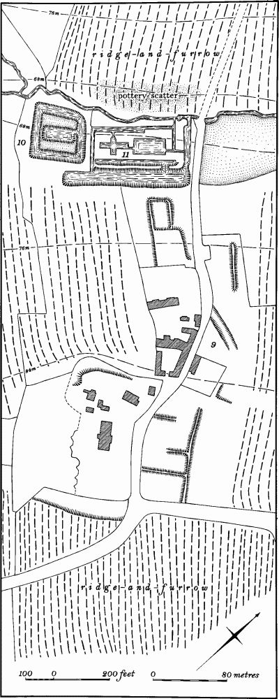
Fig. 25 Castle Ashby (9) Settlement remains of Chadstone, (10) Moat, (11) Ponds
c(9) Settlement Remains (SP 853586; Fig. 25), formerly part of the hamlet of Chadstone, lie around the existing buildings, on the S.E. side of a broad valley, on Boulder Clay at 78 m. above OD. The hamlet is first mentioned in Domesday Book where a total population of 14 people is recorded (VCH Northants., I (1902), 349). Thereafter little apart from its manorial descent is known (VCH Northants., IV (1937), 233). All the existing earthworks were already abandoned by the mid 19th century (NRO, Tithe Map, 1840). In the early 18th century there were six houses there, but foundations of former houses had already been discovered during ploughing (J. Bridges, Hist. of Northants., I (1792), 346). In 1935 'corbel stones, the base and capital of a pillar and quantities of stone used for early buildings' were said to exist in the Rectory garden (Ass. Arch. Soc. Reps., 41 (1935), 236–7). Little remains on the ground today except for some low banks, perhaps former close boundaries, immediately S.E. of Paradise Ponds, and part of a hollowway S.E. of the Rectory. However on air photographs taken before recent destruction further low banks are visible E. of the Rectory, and part of a hollow-way N. of the farm (RAF VAP CPE/UK/1926, 4008–10; FSL 6565, 1860–66).
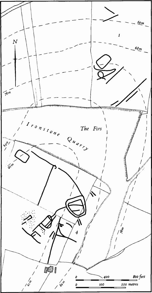
Fig. 26 Cogenhoe (1) Cropmarks, (4) Iron Age and Roman settlement
c(10) Moat (?) (SP 85055872; Fig. 25), N.W. of Chadstone, in the bottom of the valley. The site consists of an almost square island, surrounded by a shallow ditch 1 m. deep, with a large rectangular pond within it. The site has been altered, perhaps when the adjacent Paradise Ponds (11) were constructed, but was probably originally of medieval date (NRO, Tithe Map, 1840).
c(11) Ponds (SP 85075877; Fig. 25), immediately N.E. of (10) in a similar position. Known as Paradise Ponds, they now consist of an elaborate arrangement of ponds and water-courses, probably constructed in the 18th or early 19th century. They existed in their present form in 1840 (NRO, Tithe Map). However, it is possible that they originated as medieval fishponds connected with the moated site (10) of Chadstone hamlet.
(12) Cultivation Remains. The date of enclosure of the common fields of the parish is unknown but had certainly taken place before 1764 when much of the great park around the castle was laid out (VCH Northants., IV (1937), 232). Whether the hamlet of Chadstone (9) had its own fields separate from those of Castle Ashby is not known. Ridge-and-furrow of these fields exists on the ground or can be traced on air photographs over most of the parish. Within the Park, N. of the Castle, large areas of ridge-and-furrow still remain in spite of modern ploughing, arranged in end-on and interlocked furlongs often of reversed-S form. Here, on heavy clay land, the ridges still stand up to 0.5 m. high and many access-ways and headlands are preserved. In the S. of the parish most of the traceable ridge-and-furrow is arranged in end-on furlongs of reversed-S form, lying at rightangles to the contours. In the N.W. of the parish (at SP 85626098 – 65816113) what appears to be a ditched trackway (1), visible on air photographs, was once covered by a double headland between two furlongs. This perhaps suggests that the arrangement of furlongs here was determined by an earlier system of tracks or enclosures (RAF VAP CPE/UK/1926, 4006–11;/1994, 1193–7, 3183–8;/2546, 3129–31, 4129–33;F21 543/ RAF/943, 0046–51; F21 543/RAF/2409, 0158–60; F22 543/RAF/2409, 0156–60).