An Inventory of the Historical Monuments in the County of Northamptonshire, Volume 2, Archaeological Sites in Central Northamptonshire. Originally published by Her Majesty's Stationery Office, London, 1979.
This free content was digitised by double rekeying. All rights reserved.
'Desborough', in An Inventory of the Historical Monuments in the County of Northamptonshire, Volume 2, Archaeological Sites in Central Northamptonshire(London, 1979), British History Online https://www.british-history.ac.uk/rchme/northants/vol2/pp33-34 [accessed 30 April 2025].
'Desborough', in An Inventory of the Historical Monuments in the County of Northamptonshire, Volume 2, Archaeological Sites in Central Northamptonshire(London, 1979), British History Online, accessed April 30, 2025, https://www.british-history.ac.uk/rchme/northants/vol2/pp33-34.
"Desborough". An Inventory of the Historical Monuments in the County of Northamptonshire, Volume 2, Archaeological Sites in Central Northamptonshire. (London, 1979), British History Online. Web. 30 April 2025. https://www.british-history.ac.uk/rchme/northants/vol2/pp33-34.
In this section
17 DESBOROUGH
(OS 1:10000 a SP 78 SE, b SP 88 SW)
The old parish of Desborough lies immediately N. of the R. Ise which forms its S. boundary. The higher land in the N.W., between 107 m. and 145 m. above OD, is covered by Boulder Clay. From this the land drops towards the S.E. across Northampton Sand and Upper Lias Clay, to the R. Ise here flowing at some 90 m. above OD. A number of finds are recorded, several during the 19th century, and mainly from ironstone-workings. These include Bronze Age burials (1–3), and also Anglo-Saxon cemeteries (6–10).
Prehistoric and Roman
An axe-hammer is said to have been found near Desborough (NM Records).
b(1) Bronze Age Burials (SP 80408318), found in 1911 during demolition work in Paddock Lane on the S. of the town, on sand at 122 m. above OD. Two Collared Urns were discovered (in NM). One is of the Primary Series (PPS, 27 (1961), 296, No. 117), the other of the Secondary Series.
(2) Bronze Age Burials (unlocated). There are records of a number of vessels, extant or lost, found at various times in the area, but it is not clear where they were discovered or exactly how many there originally were. They include a small Collared Urn, one of the Primary Series, found in 1826 (J. Abercromby, Bronze Age Pottery, II (1912), 116, Pl. 69, No. 93; PPS, 27 (1961), 296, No. 118; NM) and another 'large cinerary urn' of which only one plain body sherd survives (NM). In addition there are three other Collared Urns in NM, two of which were found in 1908 from ironstone quarries W. of the town (SP 7982; BNFAS, 7 (1972), 2–3; see also PSA, 22 (1909), 333–4; 27 (1915), 123–4).
a(3) Bronze Age Burial, Iron Age and Roman Settlement (SP 79898277), found during ironstone-mining in 1906–8, on sand at 122 m. above OD. The following objects were discovered: a small Collared Urn, of the Primary Series, (Ashmolean Museum; PPS, 27 (1961), 297, No. 129); several other Bronze Age pots, possibly the three Collared Urns of (2); a quantity of Iron Age and Roman pottery, querns and loom weights. The most notable finds were a bronze brooch with a bilateral spiral spring of La Tene III type and the well-known 'Desborough' Iron Age bronze mirror (Frontispiece; PSA, 22 (1908), 333–7; 27 (1915), 123–4; Ant. J., 4 (1924), 151–3; J. Northants. Natur. Hist. Soc. and FC, 13 (1906), 37–43; 16 (1912), 137–8; Archaeologia, 61 (1909), 239–46; Antiquity, 34 (1960), 207–10; Ulster J. Arch., 17 (1954), 92–6).
For Saxon finds from the same site, see (8) below.
a(4) Roman Settlement (SP 79428259), immediately S.W. of (3), in a similar position and perhaps part of the same site. Ironstone-mining in 1906–8 led to the discovery of three 'early British' wells, 6 m. below the existing land surface. Associated with them were human bones, and Roman and Saxon pottery (see (8) below; PSA, 22 (1908), 333; OS Record Cards).
b(5) Roman Burials and Settlement (?) (SP 804836), found probably in the late 19th century during ironstone-mining near Desborough station, on former Boulder Clay at 128 m. above OD. Skeletons, animal bones and Roman pottery are recorded (VCH Northants., I (1902), 217). These finds, which also included an iron knife, may have come from a mound (NM Records).
Medieval and Later
b(6) Anglo-Saxon Cemetery (SP 80508307), N. of the town, on sand at 115 m. above OD. During ironstone-mining in 1876 about sixty interments were found within an 'old encampment' of which no trace survives, though a plan of this earthwork exists in the Dryden Collection (Central Library, Northampton). The bodies were in rough graves, without coffins, their heads to the W. Few of the graves contained grave goods, but from two of them came a gold necklace with garnet-set pendants, a Roman bronze pin, a bronze pan or skillet, fragments of a bronze bowl, a pair of scales, a spoon and two glass cups. Some of these may have been contained in an iron-bound wooden box (BM; Meaney, Gazetteer, 188, Desborough (1); Northants. Archaeol., 10 (1975), 165; CBA Group 9, Newsletter, 6 (1976), 20).
(7) Anglo-Saxon Cemetery (unlocated, but presumably on the line of the modern A 6 road), N.W. of the town, and found before 1757 in a gravel pit opened for the benefit of the turnpike. Several skeletons with amber and glass beads, an iron ring and several bronze clasps were discovered as well as two urns filled with bones and ashes (Meaney, Gazetteer, 188, Desborough (2)).
a(8) Anglo-Saxon Cemetery (SP 7989277), discovered with finds from (3) in 1906–8. Two Saxon pots of plain black ware are recorded and a silver necklace may have come from the same site or a little to the S.W. (at SP 79428259) where other Saxon remains are vaguely reported (Meaney, Gazetteer, 188, Desborough (3); OS Record Cards).
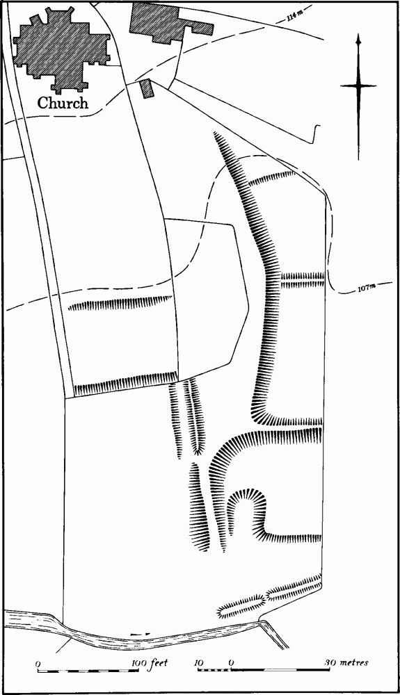
Fig. 36 Desborough (11) Earthworks
(9) Anglo-Saxon Cemetery (?) (unlocated, in the town), found in 1805 when, it is recorded, many Anglo-Saxon interments were discovered, accompanied by bronze articles (Archaeologia, 45 (1876), 471).
(10) Anglo-Saxon Burial (unlocated), perhaps from Rothwell, A small Saxon urn, now in Market Harborough Museum, is said to have been found between Desborough and Rothwell (Meaney, Gazetteer, 189).
b(11) Earthworks (SP 803829; Fig. 36) of unknown purpose, lie immediately S. of the church in, and on the W. side of, a narrow valley, on clay at about 104 m. above OD. The valley is partly blocked by a large earth bank, up to 2.5 m. high, which may be a dam, and there are two much slighter banks about 0.25 m. high, across the valley upstream. Below the dam is an area of later quarrying and a square platform with a scarped lower edge. To the W., on the side and crest of the valley, are two disconnected lengths of broad bank, the upper with a ditch on the W. side. Further N., within the present graveyard, are two parallel scarps (RAF VAP 541/612, 3027–8).
(12) Cultivation Remains. The common fields of the parish were enclosed by Act of Parliament of 1776. An undated map of the late 18th century (NRO) shows the common fields still in existence. At that time there were four fields, How, Garborough, Little and Bestow Fields, all lying around the town, and a large area of old enclosures in the N.E. of the parish (J.R. Moore, History of Desborough (1910), 15–26).
Ridge-and-furrow of these fields exists on the ground or can be traced on air photographs over large areas of the parish outside the extensive ironstone quarries. It is arranged in end-on and interlocked furlongs, some of which are of strong reversed-S form (e.g. SP 786817 and 793835). It agrees exactly with the furlongs marked on the late 18th-century map of the parish (RAF VAP 541/602, 4178–84; 541/612, 4024–8, 3024–8; F21 82/RAF/865, 0296–9, 0314–8).