An Inventory of the Historical Monuments in the County of Northamptonshire, Volume 2, Archaeological Sites in Central Northamptonshire. Originally published by Her Majesty's Stationery Office, London, 1979.
This free content was digitised by double rekeying. All rights reserved.
'Easton Maudit', in An Inventory of the Historical Monuments in the County of Northamptonshire, Volume 2, Archaeological Sites in Central Northamptonshire(London, 1979), British History Online https://www.british-history.ac.uk/rchme/northants/vol2/pp43-47 [accessed 30 April 2025].
'Easton Maudit', in An Inventory of the Historical Monuments in the County of Northamptonshire, Volume 2, Archaeological Sites in Central Northamptonshire(London, 1979), British History Online, accessed April 30, 2025, https://www.british-history.ac.uk/rchme/northants/vol2/pp43-47.
"Easton Maudit". An Inventory of the Historical Monuments in the County of Northamptonshire, Volume 2, Archaeological Sites in Central Northamptonshire. (London, 1979), British History Online. Web. 30 April 2025. https://www.british-history.ac.uk/rchme/northants/vol2/pp43-47.
In this section
21 EASTON MAUDIT

Fig. 45 Earls Barton (16) Deserted hamlet of Thorpe
(OS 1:10000 a SP 86 SE, b SP 85 NE, c SP 95 NW)
The parish covers some 730 hectares and lies against the Buckinghamshire boundary which forms its S. side. Most of the S. half is on Boulder Clay at 90 m.–110 m. above OD, but streams in the N., draining towards the Grendon Brook, have cut steep-sided valleys through limestones, silts and clays. A number of prehistoric and Roman settlements have been discovered of which by far the most remarkable lies in the S.E. of the parish, near Easton Lodge (2). This appears to have survived intact as earthworks until the very recent past when it was totally destroyed by ploughing. The village, situated towards the N. of the parish, has slight remains of former house-sites within and around it (9). Though these are typical of earthworks associated with many Northamptonshire villages they are of particular interest as they may relate to the known decrease of population in the 17th century.
Prehistoric and Roman
ab(1) Ditched Trackway (?) (SP 89176010– 89205995), in the N. of the parish, on alluvium at 52 m. above OD. Air photographs (in NMR) show a length of ditched trackway, 15 m. wide and traceable for 150 m., running in a N.–S. direction, roughly parallel to a small stream. It is intersected by a linear cropmark which marks the line of a recently removed hedge. The relationship at the point of junction is obscure.
b(2) Iron Age Settlement (SP 896571; Fig. 46), immediately N. of Easton Lodge, on Boulder Clay at 103 m. above OD. Air photographs (CUAP, BIY 98–9, BJL 88 and in NMR) show a roughly rectangular enclosure with ditches radiating from it, associated with a smaller circular enclosure to the N., as well as other ditches to the S., S.E. and S.W. On the E. two ditched trackways meet and run into the main part of the site. Iron Age pottery, bones and iron slag, as well as two querns and a polished flint axe have been found. Medieval pottery is also recorded (BNFAS, 6 (1971), 9, Easton Maudit (2); Beds. Arch. J., 3 (1966), 3; 4 (1969), 1–12; 6 (1971), 21).
b(3) Iron Age Pottery (SP 894567; Fig. 46), 400 m. S.S.W. of (2) in a similar position, has been found in this area (Beds. Arch. J., 3 (1966), 3).
b(4) Iron Age Settlement (?) (SP 897566; Fig. 46), 550 m. S. of (2) in a similar position. Late Iron Age pottery, charcoal and blackened pebbles have been found in this area (Beds. Arch. J., 3 (1966), 3).
b(5) Iron Age and Roman Settlement (?) (SP 880572) in the S.E. of the parish. S. of Cold Oak Copse, on Boulder Clay at 95 m. above OD. Large stones and Iron Age pottery were found in a modern ditch in the wood, and similar stones and pottery have been recovered from the field to the S. Roman pottery has also been discovered here as well as to the W. in Yardley Hastings parish. A Roman coin was found here in 1967 (BNFAS, 1 (1966), 5, 7; 6 (1971), 9, Easton Maudit (3)).

Fig. 46 Easton Maudit Bozeat (2) Iron Age settlement, (3) Iron Age pottery, (4) Iron Age settlement (4) Iron Age settlement, (12) Ditches, (13) Industrial sites
b(6) Roman Settlement (?) (SP 89195685), 400 m. S.W. of (2) in a similar position. Roman pottery, a quern and pieces of tile have been found, associated with dark areas of soil (Beds. Arch. J., 3 (1966), 6).
b(7) Roman Building (SP 895582), S.E. of the village, on Boulder Clay at 91 m. above OD. Much Roman pottery and a brooch have been discovered together with a large quantity of building stone, tesserae, painted plaster and flue tiles (Beds. Arch. J., 3 (1966), 3).
b(8) Industrial Sites (SP 895563, 895575 and 898564), in the S.E. of the parish, on Boulder Clay. All consist of areas of either charcoal or iron slag very similar to those known from Iron Age and Roman sites (Beds. Arch. J., 3 (1966), 3). Recent work, however, suggests that they may be medieval (CBA Group 9, Newsletter, 6 (1976) 28; Radiocarbon, 17 (1975), 268).
Medieval and Later
b(9) Settlement Remains (SP 887586–891581; Fig. 48), formerly part of Easton Maudit village, lie partly on the W. side of the existing N.–S. street on lime stone at 76 m. above OD. In 1840 (NRO, Tithe Map) there was another lane to the W., parallel to the present street. By that time the sites had already been abandoned, except for the houses which still survive today. The N. part was then known as Burnt Yard. Part of the old lane still exists as a shallow hollow-way and between it and the street are the fragmentary remains of a series of embanked and ditched closes with traces of house-sites at their E. ends. On the E. side of the village street, in modern arable land (SP 889584), is a series of patches of stone rubble containing post-medieval pottery and animal bones. Immediately E. of the present village, and S. of the site of the Manor House (11) (SP 892587) stone rubble, traces of a road, and pottery of the 12th to the 14th century, have been found in the arable land (Beds. Arch. J., 3 (1966), 3).
Some of these remains may be the result of relatively recent depopulation, for in the early 18th century Bridges noted that the population of the village had decreased considerably since enclosure in the early 17th century (J. Bridges, Hist. of Northants., II (1791), 163; VCH Northants., IV (1937), 11; CUAP, 70–LIN259–61; RAF VAP CPE/UK/1926, 4004–5; see also (10)).
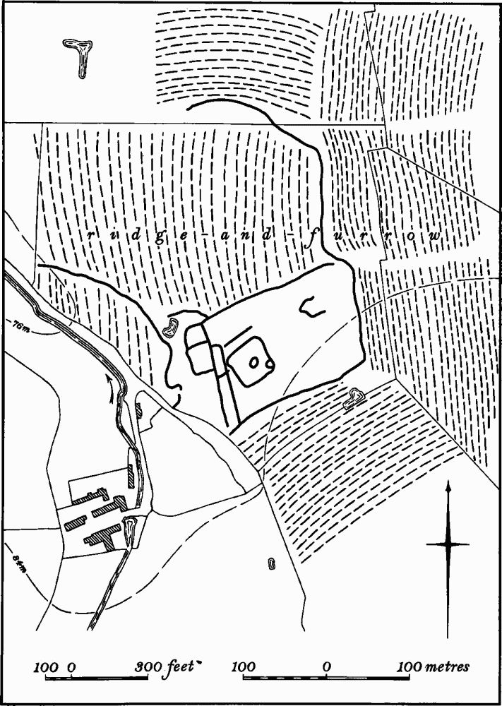
Fig. 47 Easton Maudit (10) Medieval occupation site
b(10) Occupation Site and Enclosures (SP 892582; Fig. 47), S.E. of the village, on Boulder Clay at 82 m. above OD. Air photographs (in NMR) show a large rectangular ditched enclosure, respected by the surrounding ridge-and-furrow. Within and to the W. of it are cropmarks of ditches and enclosures. The site may be the extreme S. part of the settlement remains (9) or a separate medieval site. An excavation, the exact position of which is unknown, revealed part of a stone-walled building of 13th-century date, 4.6 m. wide and at least 8 m. long with floors and yards of limestone and pebbles. Finds included pottery, animal bones and a bronze ring (Northants. Archaeol., 8 (1973), 20; CBA Group 9, Newsletter, 3 (1973), 21; Med. Arch., 17 (1973), 181–2, grid reference incorrect).
b(11) Site of Manor House and Gardens (SP 88925885; Fig. 48), lies immediately E. of the church, on Oolitic Limestone at 76 m. above OD. It is the site of the manor house of Easton Maudit, whose history has been well-recorded (Arch. J., 6 (1879), 92; Ass. Arch. Soc. Reps., 36 (1921), 95–102; VCH Northants., IV (1937), 12–14; G. Isham, Easton Maudit, (1969)).
The house was finally pulled down in 1801, but an engraving of it in 1721 suggests that it was a late medieval building, much altered and added to in the early 17th century (BM Add. MS 32467). It was probably altered and rebuilt by a member of the Yelverton family which acquired the manor in 1578 and almost certainly the new work was carried out by Henry Yelverton (1566–1629). It was a large house and was rated at 43 hearths in the 1673 Hearth Tax Returns (PRO, E179/ 254/14). In 1801 the estate passed to the Comptons of Castle Ashby who then demolished the house.
The remains consist of two distinct parts. On the E. is a series of indeterminate earthworks forming no coherent plan and these are probably the site of the house, which appears to have faced E., arranged around a small court. To the W. are two long, parallel scarps 0.25 m. high, running E.–W., which are probably the remains of the garden, presumably of the 17th or 18th century. To the N.W. is a raised circular area. On the N. side two rectangular scarped platforms project into the adjacent field. Further W. across a lane which dates from after 1840 (NRO, Tithe Map) is a modern arable field bounded on the W. by a long rectangular pond and with four cedar trees on its N. side and one on the S. The pond was probably the W. boundary of the original garden, the whole area being called Pleasure Ground in 1840.
b(12) Building (SP 898576), in Horn Wood, on Boulder Clay at 98 m. above OD. Excavations in 1965 revealed part of a stone building of medieval date (NM Records).
b(13) Fishponds (SP 88955912; Fig. 48), lie 300 m. N.N.E. of the church, on clay at 66 m. above OD. They are almost certainly medieval in origin and are likely to be associated with the manor house site to the S. (11). They consist of two long, narrow parallel ponds, with another rectangular one to the S.E., lying in the valley of a small N.E.-flowing stream. A fourth pond existed in 1840 (NRO, Tithe Map), along the N. side of the area, but this has been destroyed. The whole field was known as Lower Park in 1840.
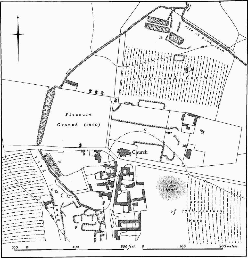
Fig. 48 Easton Maudit (9) Settlement remains, (11) Site of manor house and gardens, (13) Fishponds, (14) Pond, (15) Pillow mound
b(14) Pond (SP 886587, Fig. 48), immediately W. of the Vicarage and S. of the pond which forms the W. boundary of the former garden (11). It is a long rectang ular pond set to one side of the existing stream. It may be medieval in origin and was perhaps a fishpond. It certainly existed on 1840 (NRO, Tithe Map).
b(15) Pillow Mound (SP 88995905; Fig.48), lies immediately S.E. of the fishponds (13), on a slight N.facing slope. It is a flat-topped rectangular mound, 14 m. long and 6 m wide, lying on top of, but slightly askew to, a ridge in a block of N.–S.-orientated ridge-and-furrow.
(16) Cultivation Remains. The exact date of the enclosure of the common fields of Easton Maudit is not known but it is said to have been carried out in the reign of Charles I by Sir Christopher Yelverton. If this is so it must have taken place after 1630 when Yelverton succeeded to the manor, and it probably occurred in 1636 when he had licence to empark 500 acres S. of the Manor House (11) and immediately E. of the village (VCH Northants., IV (1937), 14).
Ridge-and-furrow of these fields exists on the ground or can be traced on air photographs over large areas of the parish. It is arranged in end-on furlongs, often with well-marked headlands between them, and with the ridges at right-angles to the contours. Ridge-and-furrow also exists in the S. of the parish which was presumably beyond the limits of the common fields and indeed is traceable within the woodland in the S.W., especially in Hill's Copse (RAF VAP CPE/UK/1994, 1198–1200, 3187–90, 2193–6; F22 543/RAF/2409, 0161–2; CPE/ UK/1926, 4001–7, 2002–6; FSL 6565, 1862).