An Inventory of the Historical Monuments in the County of Northamptonshire, Volume 2, Archaeological Sites in Central Northamptonshire. Originally published by Her Majesty's Stationery Office, London, 1979.
This free content was digitised by double rekeying. All rights reserved.
'Isham', in An Inventory of the Historical Monuments in the County of Northamptonshire, Volume 2, Archaeological Sites in Central Northamptonshire(London, 1979), British History Online https://www.british-history.ac.uk/rchme/northants/vol2/pp99-101 [accessed 30 April 2025].
'Isham', in An Inventory of the Historical Monuments in the County of Northamptonshire, Volume 2, Archaeological Sites in Central Northamptonshire(London, 1979), British History Online, accessed April 30, 2025, https://www.british-history.ac.uk/rchme/northants/vol2/pp99-101.
"Isham". An Inventory of the Historical Monuments in the County of Northamptonshire, Volume 2, Archaeological Sites in Central Northamptonshire. (London, 1979), British History Online. Web. 30 April 2025. https://www.british-history.ac.uk/rchme/northants/vol2/pp99-101.
In this section
37 ISHAM
(OS 1:10000 SP 87 SE)
The parish, W. of Burton Latimer, occupies 555 hectares and is bounded on the E. by the R. Ise and to the N. and S. by two tributary streams. The village of Isham is situated in the E. of the parish, on the tip of the spur which projects between these two tributary valleys. The higher land, rising to 100 m. above OD, is composed of clays, silts and limestones of the Estuarine Series. Northhampton Sand and Upper Lias Clay have been exposed by the down-cutting of the streams and the R. Ise, here flowing at 52 m. above OD. The settlement remains of the village of Isham (5) are of interest in that the remains of hollow-ways and closes relate to the existing street system in a way which suggests that the whole may originally have been a planned village.
Prehistoric and Roman
Roman coins are said to have been found in the parish but their provenance is unknown (Arch. J., 35 (1878), 271). Roman pottery has been found W. of the village at SP 878737 (NM Records).
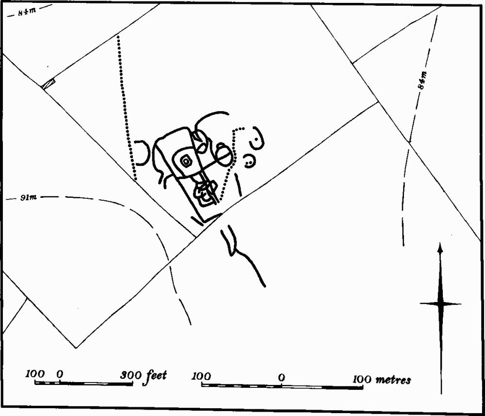
Fig. 94 Isham (1) Iron Age and Roman settlement
(1) Iron Age and Roman Settlement and Pit Alignments (SP 867737; Fig. 94), in the W. of the parish, on limestone at 90 m. above OD. Air photo graphs (in NMR, and CUAP, YX 86–9) show a series of rectangular and irregular ditched enclosures with various interior features, including some apparent hut-circles and pits. Two pit alignments cut obliquely across the site. Several sherds of Roman pottery were found on the edge of the site in 1966 (BNFAS, 2 (1967), 12). Later fieldwork produced a wide scatter of Roman pottery and a small area with allegedly hand-made Iron Age pottery on it. Some worked flints were also discovered (BNFAS, 4 (1970), 4; 6 (1971), 14).
(2) Roman Settlement (SP 886738), in Isham village, in the area immediately S. of the church, on sand at 73 m. above OD. Building work revealed two curving parallel ditches, one of which was excavated. This contained samian and other Roman pottery, building materials, including tiles and tesserae, and animal bones. Sherds of pre-Roman date and several flint 'tools' were found in pipe trenches. Roman pottery has been found at two other places in the village, N. of the church (SP 88527406) and S. of South Street (SP 88787384) (BNFAS, 2 (1967), 12; OS Record Cards; see also (4) below).
(3) Roman Settlement (?) (SP 872735), 500 m. S.E. of (1), on limestone at 73 m. above OD. Roman pottery has been found here over a number of years, and more was discovered during building construction in 1966 (BNFAS, 2 (1967), 12; OS Record Cards).
Medieval and Later
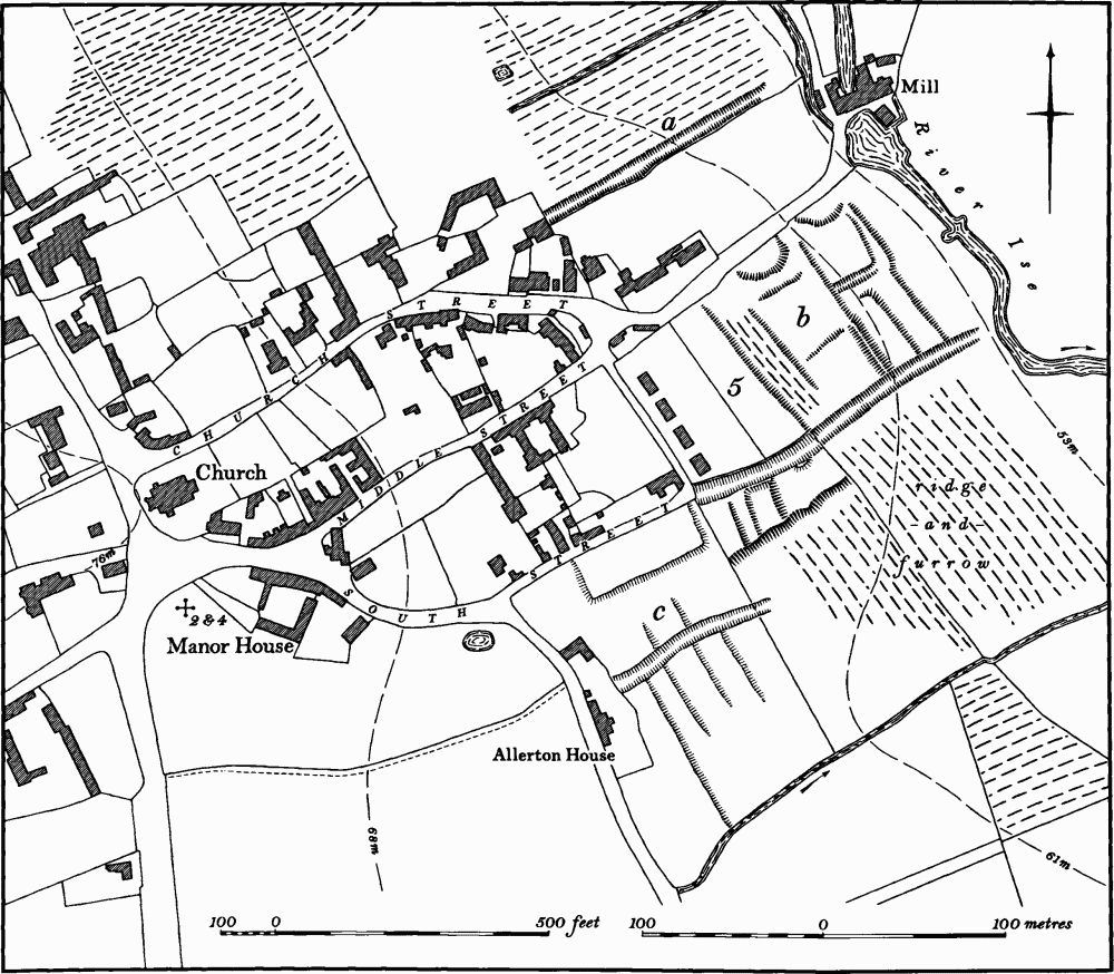
Fig. 95 Isham (2) Roman settlement, (4, 5) Settlement remains
(4) Settlement Remains (SP 886738; Fig. 95), formerly part of Isham village found in 1966 overlying the Roman material described in (2) and in the adjacent area. Some sherds of St. Neots ware were discovered as well as Stamford ware, but most of the pottery dated from 1100 to 1300. Pots, glazed roof tiles and ridge tiles, probably from Lyveden, were also found.
Elsewhere in the area excavation revealed a stone hovel, or barn, from which came slag and a pair of iron tongs and 13th-century pottery. This stood in a plot of land between two parallel ditches. Hearths and several pits containing 13th-century pottery were exposed. Further pits and the remains of another stone building were also noted (BNFAS, 2 (1967), 25–6). Further work in 1968 led to the discovery of a well-head, associated with St. Neots, Lyveden and Oxford-type wares. An undated oven was also found (BNFAS, 3 (1969), 23–4).
(5) Settlement Remains (centred SP 888740; Fig. 95), formerly part of Isham, lie in and around the existing village. The surviving earthworks, and in particular the hollow-ways, appear to be part of the plan of the existing village and may represent a consciously planned medieval layout. As a result of modern housing development and other alterations some of the evidence has been destroyed and is only visible on air photographs taken in 1947.
The remains fall into three parts. On the N.E. side of the village ('a' on Fig. 95) is a broad hollow-way which continues the line of Church Street towards the mill (SP 88757413). S. of the mill ('b' on Fig. 95) and S. of the N.E. end of Middle Street is a series of embanked and scarped closes which extend S.E. to meet another shallow and somewhat indistinct hollow-way which continues the line of South Street (SP 888740). Slight depressions at the N.W. ends of these closes may be former house-sites fronting Middle Street and it is possible that other buildings once existed at the other end, fronting the hollow-way. One of the closes has slight traces of rather narrow ridge-and-furrow on it. The junction of the hollow-way with South Street has been largely destroyed by modern building, but is clear on air photographs. Immediately to the S. and still partly surviving are the fragments of further closes. On the S. side of South Street and N.E. of Allerton House ('c' on Fig. 95) air photographs show other remains now totally destroyed by modern housing and a new wood (SP 888738). These appear to have consisted of a shallow hollow-way, running parallel to the existing village streets, on either side of which were traces of scarped closes. The area now occupied by the wood was watched during planting around 1968, and medieval pottery, foundations, ditches etc. are said to have been found.
The period of desertion of these remains is unknown and the available population statistics give no indication. In 1086 Domesday Book lists 18 people (VCH Northants., I (1902), 343, 349). In 1377 93 people over the age of 14 paid Poll Tax (PRO, E179/155/28) and in 1674 59 people paid Hearth Tax (PRO, E179/254/14). In 1801 the total population of the parish was 247. The earliest surviving map of Isham, of about 1800 (NRO) indicates that the area of the earthworks had been abandoned by that date (RAF VAP CPE/UK/1925, 2351–2, 3241–2).
(6) Cultivation Remains. The common fields of the parish were enclosed by Act of Parliament in the 18th century (NRO, Enclosure Map, 1779).
Ridge-and-furrow of these fields exists on the ground or can be traced on air photographs mainly around the edge of the parish. Here the ridges are almost all at rightangles to the contours and to the streams which run along the N. and S. boundaries (e.g. SP 877746–886747 and 872727–893734). On the higher flatter ground where ridge-and-furrow survives it appears to be arranged in interlocked furlongs. A number of former headlands between end-on furlongs survive on the ground as long ridges, up to 300 m. long and 25 m. wide (e.g. SP 878743; RAF VAP CPE/UK/1925, 2242–38, 2350–8, 3235–44, 3351–7; F22 540/RAF/1312, 0165–9, 0204–10).