An Inventory of the Historical Monuments in the County of Northamptonshire, Volume 3, Archaeological Sites in North-West Northamptonshire. Originally published by Her Majesty's Stationery Office, London, 1981.
This free content was digitised by double rekeying. All rights reserved.
'Lamport', in An Inventory of the Historical Monuments in the County of Northamptonshire, Volume 3, Archaeological Sites in North-West Northamptonshire(London, 1981), British History Online https://www.british-history.ac.uk/rchme/northants/vol3/pp114-125 [accessed 30 April 2025].
'Lamport', in An Inventory of the Historical Monuments in the County of Northamptonshire, Volume 3, Archaeological Sites in North-West Northamptonshire(London, 1981), British History Online, accessed April 30, 2025, https://www.british-history.ac.uk/rchme/northants/vol3/pp114-125.
"Lamport". An Inventory of the Historical Monuments in the County of Northamptonshire, Volume 3, Archaeological Sites in North-West Northamptonshire. (London, 1981), British History Online. Web. 30 April 2025. https://www.british-history.ac.uk/rchme/northants/vol3/pp114-125.
In this section
42 LAMPORT
(OS 1: 10000 a SP 77 NW, b SP 77 NE, c SP 77 SW, d SP 77 SE)
Lamport now includes the old parish of Faxton which was once a parochial chapelry of the former. It is very large, covering nearly 1900 hectares, and is shaped like a 'W'. Much of it lies on a flat-topped N.–S. ridge with a maximum height of 150 m. above OD, capped by Boulder Clay, but the down-cutting of numerous small streams within and on either side of this ridge has formed a rolling landscape of Northampton Sand and Upper Lias Clay. There is a small area of alluvium in the valley of the main S.-flowing stream to the W. of the village.
The parish of Lamport contained not only the village of Lamport itself but also the hamlet of Hanging Houghton where the site of the manor house and gardens (13) lies on a small steep-sided spur. The village of Faxton (15) was finally depopulated in this century after a long and complex history. Although the greater part of the extensive earthworks have been destroyed by ploughing some excavation was carried out before this. In common with other villages in this part of the county all three settlements in the parish lie on high ground.
Prehistoric and Roman
d(1) Ring Ditch (?) (SP 756748), on the valley side to the E. of the fishponds (9), on Northampton Sand at 130 m. above OD. A circle of dark earth about 25 m. in diam. and a scatter of worked flints are visible when the land is ploughed.
c(2) Enclosures (SP 732735), in the S.E. of the parish, on Upper Lias Clay, at 110 m. above OD. Air photographs (in NMR) show very indistinct cropmarks of a small group of interlocked sub-rectangular and oval enclosures covering about 1 hectare.
a(3) Enclosure and Trackway (SP 746750; Fig. 89), W. of the village, on Upper Lias Clay, at 100 m. above OD. Air photographs (in NMR) show parts of a rectangular enclosure with irregular sides and an apparent entrance on the S.W. To the S. is a length of ditched trackway and further S. again perhaps part of another enclosure.
d(4) Barrow (?) (around SP 784749), lay close to the E. boundary of the parish, on clay at 122 m. above OD. A tumulus was recorded southward of Faxton church' in 1849 (Wetton, Guide-Book (1849), 105) but no trace of a mound is visible on the ground or from air photographs.
b(5) Barrow (?) (SP 77437565; Fig. 95) lay 250 m. S.E. of Shortwood House, on clay at 145 m. above OD. Until it was destroyed in 1964 there was a mound 0.8 m. high and 11.5 m. in diam. with no trace of a ditch; it was perhaps a bowl barrow (OS Record Cards). On air photographs taken before destruction (RAF VAP CPE/UK/1925, 4367–8) it appears that the mound was respected by the surrounding ridge-and-furrow.
d(6) Barrow (?) (SP 75547374), lies at the junction of the A 508 and the road to Hanging Houghton on Northampton Sand at 144 m. above OD. A mound 1.2 m. high and 17 m. in diam., cut by the road on its S. side, is perhaps a bowl barrow (Wetton, Guide-Book (1849), 102; OS Record Cards).
For two other mounds sometimes described as barrows, see (10) and (11).
b(7) Roman Settlement (?) (SP 784753), probably lay on the site of the deserted village of Faxton, on Northampton Sand at 137 m. above OD. During excavations in 1968 Roman pottery and two Roman coins were recovered from the medieval crofts on the S. and E. sides of the village. The excavator suggested that this material had been washed down the hillside from an assumed Roman site above, perhaps near the medieval manor house site (16) (Current Arch., 16 (1969), 145–7; BNFAS, 3 (1969), 21). Subsequent field-walking on the manor house site, now ploughed, has revealed more Roman pottery.
For Roman site at SP 760757, see Draughton (9).
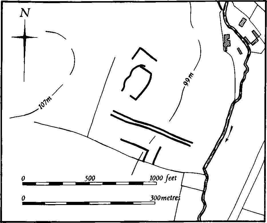
Fig. 89 Lamport (3) Cropmarks
Medieval and Later
A small Anglo-Saxon pot was found in the parish in the early years of the century (OS Record Cards; NM).
d(8) Settlement Remains (SP 757745; Figs. 90 and 91), formerly part of Lamport village, lie along the main village street between and behind the existing houses and in the park of Lamport Hall, on Northampton Sand between 120 m. and 145 m. above OD.
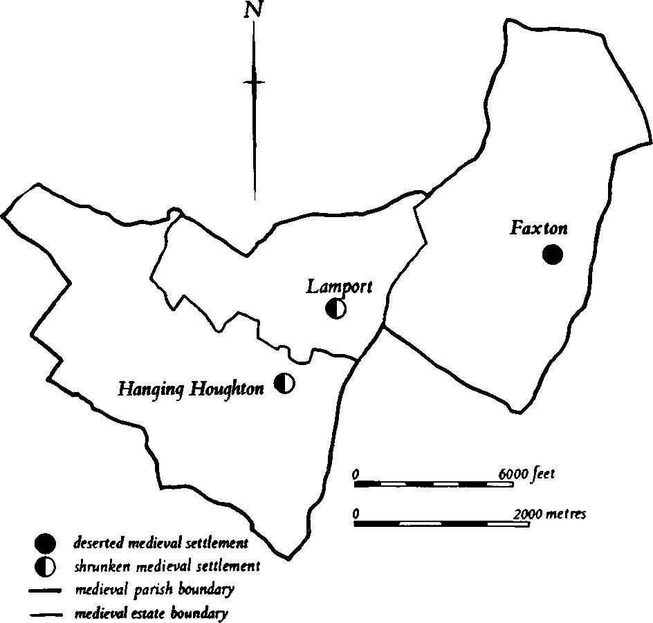
Fig. 90 Lamport Medieval settlements and estates
The admittedly inadequate population statistics for the village do not indicate a marked fall in population at any time. In 1086 Domesday Book records a total population of 23 (VCH Northants., I (1902), 318, 340, 350). Ninety people over the age of 14 paid Poll Tax in 1377 (PRO, E179/155/28), and in 1673, 37 people paid the Hearth Tax (PRO, E179/254/14). By 1801, 148 people lived in the parish; some of these would be on the outlying farmsteads which had been established by that date.
The surviving remains are very fragmentary and difficult to interpret. At the W. end of the village and N. of the present houses there is a large area of land covered with earthworks including a hollow-way ('a' on plan) which appears to have led off the existing road to Market Harborough but is blocked at the N. by a later scarp; another hollow-way ('b' on plan) extends up the valley towards the village. Between these two hollow-ways lies a small enclosure ('c' on plan), bounded on the N. and W. by a low bank and external ditch and set inside a large enclosure edged by low scarps. To the N. are other indeterminate earthworks. On the other side of the village street and just inside the park ('d' on plan) are more scarps and a short length of hollow-way. The former may be the sites of buildings. Further low scarps at the N.E. end of the village ('e' and 'f' on plan) form a generally rectangular pattern and may also be former house-sites.
d(9) Fishponds (SP 755748; Fig. 91), lie N.W. of the village, in a steep-sided valley cut into Jurassic Clay, at 113 m. above OD. Three roughly rectangular ponds set into the valley bottom are separated by massive earthen dams 2.5 m.–3 m. high. The dam of the lowest pond has been much altered in recent times; it has an ashlar rear face and a 19th-century stone sluice in its centre.
d(10) Windmill Mound (SP 75787377), lay E. of the road to Hanging Houghton, on Boulder Clay at 144 m. above OD. A mound 24 m. in diam. and 1.5 m. high, surrounded by a ditch 1 m. deep and 7.5 m. wide, has been destroyed by ironstone-mining, but was excavated in 1954. The remains of two mills, one a post mill of the 13th to 15th centuries and the other dating from the 17th century, were discovered. A number of flints of Neolithic or Bronze Age type were found within the mound and it is just possible that this was a prehistoric barrow re-used as a mill mound (J. Northants. Nat. Hist. Soc. and FC, 33 (1956), 66–79; J. M. Steane, The Northants. Landscape (1974), 115).
d(11) Mound (SP 76207421), lies 400 m. S.E. of Lamport Hall, in the park, at 145 m. above OD. The mound has been described as a barrow and as such is scheduled as an ancient monument, but it is much more likely to be a relatively late landscape feature connected with the park. It is slightly oval, 8 m. by 10 m. and 3.8 m. high, sharply conical in form with traces of a ditch on its S.W. side. Immediately to the E. is a slight square depression which has recently been partly filled in but originally was a deep rectangular pond, the spoil from which appears to have been used in the construction of the mound (local inf.). The pond cuts through the adjacent ridge-and-furrow.
d(12) Garden Remains (SP 759744; Fig. 91), presumably late 16th or early 17th-century in origin, lie immediately S.E. of Lamport Hall on land sloping very gently N.W. at 145 m. above OD. A medieval manor house probably stood on the site of the present hall and this earlier house was bought in 1560 by John Isham, citizen and mercer of London, and his brother Robert. In 1568 John Isham built the new manor house on the site of the medieval one and this was extended by his grandson Sir John Isham in 1610–11. This house faced N.W. towards the church and had a forecourt enclosed on each side by long ranges of stables, the E. range of which still stands. In 1654 Sir Justinian Isham engaged John Webb to build a new addition to the existing house. Webb designed a small rectangular block in the classical style which was erected at the S.W. end of the 16th-century house. This building was extended to the N.W. in 1732 and to the S.E. in 1741, the latter activity entailing the destruction of part of the original 16th-century house. Further alterations were made in 1821 and 1842 and the whole of the present N.W. front was added in 1861.
The remains of former gardens exist to the S.E. and S.W. of the hall but it is difficult to assign all the features to any particular period. There is no doubt, however, that John Isham, the builder of the 16th-century house, laid out gardens around it, for his grandson Sir Thomas Isham wrote that 'he aplyed himselfe to plantinge, buildinge, making to pooles ...'. In a diary of 1671–73 kept by Sir Thomas there is mention of a mount in the garden as well as walks and a bowling green. Sir Thomas later ordered numerous changes in the gardens around the hall for in 1678 his agent, Gilbert Clerke, wrote 'we are going to gravell ye walks and make Garden monstrous fine ...'. This undertaking included the construction of the existing terrace-walk and the stone-walled kitchen garden and perhaps the demolition of the earlier mount. The terrace-walk is a large flat-topped bank 1.5 m.–2 m. high running along the S.W. and S.E. sides of the garden, so arranged as to be square to the earlier house but not to the later one. The work almost certainly included the laying out of an enclosed garden bounded by terraces on the S.W. side of the house, on the front of Webb's building, as depicted in a drawing of 1721 (BM Add. MS, 32, 467, f. 149). After the 18th-century additions to the hall this garden was swept away and replaced by a circular carriage-drive set in open parkland shown in a drawing of the house in 1761 (at Lamport Hall).
The garden terrace to the S.E. of the hall seem to have survived these alterations and, apart from some minor changes including the insertion of a ha-ha along the outside of the S.E. terrace probably carried out in the 1840s by Sir Charles Isham, they have remained intact since the late 17th century. To the S.W. of the hall the mid 18th-century carriage-drive must have been replaced at an unknown date for no trace of it exists today. Its place is taken by a large, nearly square, level area, bounded by low scarps nowhere above 0.5 m. high, which may represent a garden laid out after 1761 but before 1861 when the main entrance hall was moved to the present N.W. front and the present balustraded parterre built (Country Life, 112 (1952), 932–5, 1022–5; 128 (1960), 1104–7, 1164–7).
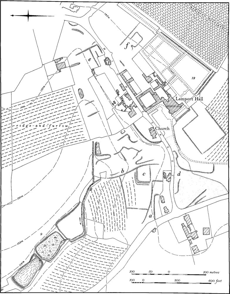
Fig. 91 Lamport (8) Settlement remains, (9) Fishponds, (12) Garden remains at Lamport
bd(13) Manor House Site and Garden Remains (SP 750737; Fig. 92), lie immediately S. of Manor Farm, at the W. end of the main street of the hamlet of Hanging Houghton, on the crest and slopes of a S.W.-projecting spur of Northampton Sand between 122 m. and 127 m. above OD. The site is certainly that of the medieval manor house of Hanging Houghton, although the extant earthworks are an abandoned garden of the late 16th or early 17th century. A Richard Mountygowe of Hanging Houghton who is recorded in a document of 1471 has been plausibly identified as Richard Montagu, father of Thomas and grandfather of Sir Edward Montagu, Lord Chief Justice. The latter probably lived at Hanging Houghton until he moved to Hemington in 1540. At his death in 1556–7 he left his land, including that at Hanging Houghton, to his son Edward and it remained with the family until 1670 when it was sold to Sir Justinian Isham (VCH Northants., IV (1937), 198–9). Bridges (Hist. of Northants., II (1791), 116), writing in the early 18th century, said that the manor house was deserted in 1665 after the Montagu household had been carried off by the plague, to escape which they had fled from London. This indicates that the Montagus still used the manor house until 1665. It still stood, but in ruins, in Bridge's day. On a map of the parish of 1655 (NRO) the house is depicted standing at the N.E. corner of an elaborate formal garden, comprising knot-gardens and terrace-walks. The S., front elevation of the house is shown indicating that it was of three bays, with a symmetrical elevation, probably with a central porch. It seems to have been of late 16th or early 17th-century date.
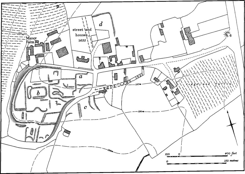
Fig. 92 Lamport (13) Site of manor house and gardens, (14) Settlement remains at Hanging Houghton
The earthworks consist of a series of rectangular areas bounded by low scarps and banks, nowhere above 0.5 m. high, set inside a continuous curving scarp up to 4 m. high which encloses the site on the W. and S. The position of the manor house ('a' on plan) is marked only by a low scarp; the boundaries of two rectangular knot-gardens immediately to the W. also partly survive as scarps. Further W. ('b' on plan) is a larger rectangular scarped area, which in 1655 was a system of paths bounding a square area planted with trees, and with trees in a broad arc outside it (RAF VAP CPE/UK/1994, 1378–9; CUAP, AK70; air photographs in NMR).
d(14) Settlement Remains (SP 751736; Fig. 92), formerly part of the village of Hanging Houghton, lie on the S. side of the village, on Northampton Sand at 130 m. above OD. The village is now laid out along a single E.–W. street, with a broad open space or green at its E. end. However in 1655 (Map in NRO) the village had a completely different appearance. The present main street was there, but no houses stood further E. than the W. edge of the green, which then did not exist. To the S. of the main street was a back lane, along which lay at least three buildings, and on the N. side a short cul-de-sac was lined with eight houses and their gardens, four on each side, forming a neat rectangular block. Further S., to the S. of the manor house (13) which then stood in the corner of its formal gardens, three other houses lay on the S. side of the lane to Cottesbrooke.
On the ground a few indeterminate scarps ('c' on plan) mark the sites of the houses on Cottesbrooke Lane. Part of the back lane survives, but no trace remains of the houses on the N. side of the village. The latter area has been ploughed and then returned to grass and only a low scarp indicates the possible boundary of the former closes ('d' on plan; RAF VAP CPE/UK/1994, 1378–9; CUAP, AKP70).
b(15) Deserted Village of Faxton (SP 784753; Figs. 90, 93 and 94; Plates 6 and 7), once the centre of the former parish of Faxton, lies in the E. of Lamport parish. It is situated on the slopes of a S.-projecting spur between two S.-flowing streams from 138 m. to 114 m. above OD. The top of the spur is capped by Northampton Sand but at the N. end of the village this is in turn overlaid by Boulder Clay. The valley sides are cut into underlying Upper Lias Clay.
The history of Faxton appears complex but, significantly, this is due at least in part to the large amount of information known about it. Without the evidence of the post-medieval maps and the results of excavations a relatively simple but erroneous picture could be drawn.
Faxton is first recorded in Domesday Book though it may have originated earlier as the first element of its name possibly represents a Scandinavian personal name (PN Northants., 124). In 1086 Domesday Book lists Faxton as a two-hide manor held by the King, with a recorded population of 21. In most later medieval documents, however, Faxton is linked with the deserted village of Mawsley (RCHM Northants., II, Loddington (6)), and it may be that the entry for Faxton in Domesday Book also includes Mawsley which is otherwise unrecorded. This evidence for a settlement here in the 11th century and earlier is apparently at variance with archaeological findings which would indicate a 12th-century origin for the village (see below). Faxton is listed in the 1316 Nomina Villarum, and in 1334, together with Mawsley, paid 38s. 8d. for the Lay Subsidy (PRO, E179/155/3). In 1377, 94 people over the age of 14 paid the Poll Tax (PRO, E179/155/27) but this figure again includes the inhabitants of Mawsley. Nevertheless the large number of people involved suggests that Faxton was a considerable community. In 1674, 34 householders paid the Hearth Tax (PRO, E179/254/14) and in about 1720 Bridges (Hist. of Northants., II (1791), 92) noted that there were 32 houses there including the manor house. Taken at their face value these figures do not indicate a marked drop in population at any one time. One might suggest that there may have been some 20 households in 1086, and a similar number in 1377, rising to the 34 of 1674. However at least 50 probable house-sites can be identified and the archaeological evidence implies that at least some of these were abandoned around 1400. Two alternative explanations can be given: either the village expanded rapidly, after 1086 according to Domesday Book, or after 1150 according to the archaeological record, then declining in size in the late 14th or early 15th century, or the earthworks represent a history of settlement movement within the village. At the moment there is no real evidence for the latter theory.
The earliest cartographic representation of Faxton is a map of 1746 (NRO; Fig. 94). This shows some reduction in size since 1720 when Bridges said there were 32 houses; the manor house had been demolished and the medieval church was isolated except that Rectory Farm, an early 17th-century building, stood immediately to the E., with another building to the E. again. Further N. was a row of almshouses containing four tenements which had only been built a few years before in 1736 (VCH Northants., IV (1937), 172). On the N. side of the village were three farms, and at least ten cottages which may have been sub-divided into separate tenements in which case the map probably represents between 20 and 30 dwellings. In 1745 the open fields of the parish were enclosed. By 1801 the total population of the parish was only 54, living in 15 houses, including people living in two outlying farmsteads, so the village had presumably been reduced further in size by this date.
By 1831 the population had risen to 103 and on the Tithe Map of Faxton (NRO, 1840; Plate 7) a picture slightly different from that of 1746 is depicted. The church, Rectory Farm and the almshouses remained, as did the three farms, but six of the cottages shown in 1746 had disappeared and two new ones had been built on previously empty plots. This evidence shows that though Faxton was physically smaller it was greater in population than it had been a century before. Between 1840 and 1874 (Map in NRO) the population of the parish fell again. In 1841, 108 people lived there, in 1851, 95, in 1861, 79 and in 1871, 73. On the 1874 plan one of the post 1746 cottages had been demolished, between 1874 and 1889 one of the farms was removed and replaced by a pair of estate cottages and by 1901 only 11 houses were occupied. These comprised Rectory Farm, the four tenements in the almshouses, two estate cottages, two farms and another pair of cottages. By 1921 only 37 people lived in the parish. Since that time all the houses have been abandoned and all but the late 19th-century estate cottages demolished. The church was pulled down in 1958 and by 1967 the village was entirely depopulated. The remaining cottages have recently been reoccupied as a single dwelling (K. J. Allison, et al., The Deserted Villages of Northants. (1966), 39–40; M. W. Beresford, The Lost Villages of England (1954), 367; OS Record Cards).
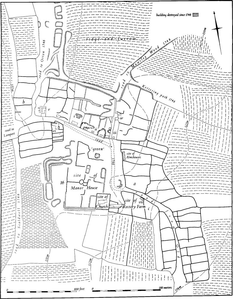
Fig. 93 Lamport (15) Deserted village of Faxton, (16) Site of manor house
Until 1966 the earthworks of the village remained intact but then the entire area was bulldozed and ploughed, with the exception of the W. part of the manor house site (16), two small paddocks on the N. side of the village and the hollow-way and ridge-and-furrow to the N. The accompanying plan (Fig. 93) has therefore been compiled partly from a survey of the remaining earthworks and from OS plans made before destruction, but mainly from air photographs taken before and after bulldozing. It is not necessarily either complete or wholly accurate.
The main part of the village seems to have lain along the N. and E. sides of a roughly triangular open space or green on the flat top of the sandstone spur. This area has the appearance of a green on all maps, and on an undated but probably 19th-century sketch map of the village (NRO) the area is specifically marked as 'The Green'. The S.W. side of the green was occupied by the medieval and later manor house (16), with the church in the S.E. corner. Along the E. side of the green were three roughly rectangular crofts extending E. down the slope, each with a small close behind it. Within the northernmost of these crofts the mid 18th-century almshouses were situated. To the N. were two long narrow closes, the N. one sub-divided into three. On the N. side of the green a row of small closes still survives as earthworks with, at the W. end, the sole surviving house, the rebuilt late 19th-century estate cottages ('i' on plan), lying within the close of an earlier building which was there in 1746 and remained until just after 1874. To the E. in a separate paddock are the N. ends of four closes, bounded by low scarps only 0.25 m. high. The S. ends of the scarps have been destroyed and only very disturbed ground, possibly later quarry-pits, remains. Three of these closes had buildings standing within them at their S. ends in 1746, one of which survived until the late 19th century though the other two had been demolished by 1840 ('ii' on plan). One of the central closes, which was empty in 1746, had a small building within it in 1840 which also survived until the late 19th century.
Immediately N. of these closes, in the next paddock, is a series of low scarps and shallow ditches, probably the remains of close boundaries, but the E. part has a large irregular pit dug into it. In the N.E. corner of the green, to the E. of the last surviving close, is a narrow foot-path running N. and now overgrown. This represents the main medieval road running N.E. out of the village. At the S. end of its E. side there was formerly a long narrow close which, in 1840, had a building at its S. end; this building had been demolished before 1874 ('iii' on plan). To the N. again are the remains of a brick-built cottage which was still occupied in the 1930s and was known as Cliffdale Cottage ('iv' on plan). The remaining structure is of 19th-century date but it stands on the site of earlier buildings shown on all the maps from 1746 onwards. In the area E. of this cottage there was a large rectangular paddock sub-divided into at least five closes, some with interior features of unknown form. Opposite the remains of Cliffdale Cottage the 1746 map shows another building on the opposite side of the lane. This had disappeared by 1840.
The lane or foot-path continues N. from Cliffdale Cottage and, at the N.E. corner of the existing paddock, opens out into a broad hollow-way running N.E. At this point another hollow-way running along the outside of the paddock joins it from the W. This latter hollow-way is not shown on any map. The main N.E. one, however, is marked on the 1746 map as the 'Road to Mawsley Wood'. For the first 150 m. it is a hollow-way up to 1.75 m. deep with ridge-and-furrow on either side. Just N. of its junction with the W. hollow-way a third hollow-way joins it from the E. but this is only traceable for a few metres although on the 1746 map it is shown as a track running down the hillside and described as 'A Bridle Way called Kettering Path'. It seems to have crossed the ridge-and-furrow which still survives here though in a mutilated form.
In 1746 The Green is shown with a road along its N. and E. sides. The N. road left the green at its N.W. corner and became a hedged track which still exists, leading to Lamport. On the N. side of this track is a small field which was formerly divided into at least four closes extending N. from the track, with four more closes of varying size to the N. of them. In the westernmost of the closes was a farm-house and associated buildings which were demolished only in 1966; a farm is shown on all the maps since 1746 ('v' on plan). Within one of the central closes there was another building in 1746 but this had disappeared by 1840. To the S. of the track was a large rectangular hedged paddock, now deserted, which was divided into four long closes running E.–W. To the E. of this, and in the N.W. corner of the green, was another group of smaller closes which look as if they were an encroachment on the green. In 1746 the northernmost of these closes had a farm within it ('vi' on plan), and the close to the S. had a cottage at its E. end. Both the farm and the cottage existed in 1840 and 1874, but though the farm remained until the 1960s, the cottage was demolished soon after 1900.
The track from the N.W. of the green ran along the N. side of the hedged paddock to the N.W. corner, and then forked. One track ran on W. down the hillside and still survives as a farm track. This is shown as the 'Road to Lamport' in 1746. The other fork ran S. and is traceable as a narrow strip of land between blocks of ridge-and-furrow. In 1746 it continued to Scaldwell.
To the N. of the hedged paddock another track leaves the main one, for the first 100 m. as a hedged lane. It then forks; one branch, a broad hollow-way 1.5 m. deep, turns E. to pass N. of the N. closes of the village and joins the hollow-way to Mawsley Wood. Another branch, much rutted, runs N.E. into a headland of the adjacent ridge-and-furrow. The main track continues N., and though hardly visible today as a road on the ground it is marked on the 1746 map as the 'Road to Orton'. Between the line of this road and the ridge-and-furrow to the E. are some uneven mounds up to 1 m. high. Their function is unknown and they may simply be the remains of ridge-and-furrow which once extended in this direction.
On the W. side of this track to Orton, near its junction with the Lamport track, were at least six small embanked closes ('b' on plan). Before destruction the S. one appears to have had narrow-rig ploughing over it.
At the S.E. corner of the green stood the small church dedicated to St. Denis. It was mainly 13th-century but incorporated some 12th-century work. New windows were inserted in the 14th century when the chancel arch was also rebuilt and the clearstorey was added in the 15th century. In formal terms the building was a chapel of ease of Lamport and this was certainly the case from 1208 onwards. However as early as 1180 there was a dispute between the Priory of Lewes which held it and the rector of Lamport over the burial of dead parishioners and this suggests that perhaps from its foundation the building was a chapelry of Lamport (VCH Northants., IV (1937), 171–2). Immediately to the E. of the church, inside a small close, stood Rectory Farm, a two-storey stone building of the early 17th century with later barns at each end (Current Arch., 16 (1969), 145).
From this point, S.E. of the green, a track ran S.E. down the hillside and then turned S. and in 1746 this was called the 'Road from Old'. Along the S. side of its upper part there were three rectangular closes. At the N. end of the central close there was a small building in 1746 which had gone by 1840 ('vii' on plan). The N. side of the track was edged at its W. end by the southernmost of the closes along the E. side of the green, and at its E. end by two more closes extending down the slope. The part of the track beyond the point where it turned S. was lined with further closes arranged in a neat rectangular pattern with nine long closes on the E., and six much smaller closes on the W. with a long paddock orientated N.–S. behind them.
Three seasons of excavation were carried out on the village before and during the final destruction of the site. In 1966 the southernmost croft on the E. side of the green was examined ('a' on plan). The main occupation area was found to be at the W. end adjoining the green. Further E. was a backyard and beyond, down the slope, was the kitchen garden or rubbish dump. Four periods of occupation were found, as follows:
Period I, 1200–1250. A long-house orientated E.–W. was constructed on a built-up clay platform. The house was made of mud walls, and post-holes for timber were found. A contemporary barn lay to the N.
Period II, 1250–1300. A bigger long-house orientated N.–S. was erected, with opposed doors, clay side-walls and stone sleeper-walls at the ends. Later the side-walls were given stone footings. To the W. was a barn and to the S., in the yard, a circular oven for baking and a lined water-trough.
Period III, 1300–1350. A new house was built at the N. end of the previous house and the latter was reduced to a barn. The new house, also orientated N.–S., was similar in construction to the earlier one. A second water-trough and several sheds also dated from this phase.
Period IV, 1350–1400. The Period III house was enlarged to the N. and W. and divided into three rooms. The farm buildings were improved and a new building, possibly a byre, was erected as well as an oven or kiln for drying corn and peas.
The pottery from Period I was mainly late Stamford ware and from the later periods mainly Lyveden ware. Other finds included coins of Henry III and Edward I, bronze rings, buckles, sheep bells, knives, spurs and weaving-slides (Current Arch., 2 (1967), 48–50; Med. Arch., 11 (1967), 307–9).
In 1967 excavation was carried out on the four southernmost crofts at the N.W. end of the village ('b' on plan). All four crofts showed similar sequences of occupation. The earlier houses were constructed of timber uprights sunk into the natural clay, presumably with mud walls. These were replaced by buildings with a timber framework resting on a sill-beam. Later structures had low foundations of boulders, pebbles and ironstone and the last phase of building used substantial foundations of ironstone and limestone slabs. All the houses were rectangular with central fireplaces. The dates for the occupation of this area ranged from about 1150 to 1350. No coins were found; the metal work was sparse but included iron keys, a buckle, knives, a harness-pendant and a pin-head. Most of the pottery was of Lyveden types. The excavator's impression was that this area was occupied by dwellings poorer than those excavated in the previous year, described above, and had been abandoned at an earlier date (Current Arch., 6 (1968), 163–4; BNFAS, 2 (1967), 23–4; Med. Arch., 12 (1968), 203).
In the final season of excavation in 1968 work was concentrated on the small croft occupied by Rectory Farm which had recently been demolished. Six main structural phases were discovered and these were as follows:
Phase I, mid 12th-century. A sub-rectangular timber structure with large post-holes, was set parallel to but well away from the street.
Phase II, late 12th to early 13th century. The existing structure was modified by the insertion of a series of sill-beams.
Phase III, mid 13th-century. The earlier building was abandoned and a new one was erected close to the street. This had mud walls on a foundation of ironstone and boulders. Traces of farm buildings around the yard were also discovered.
Phase IV, late 13th-century. The previous house was abandoned and replaced by a new one close by. This, again, had a mud-wall construction.
Phase V, early 14th-century. Another new house, built of substantial coursed limestone rubble up to 1 m. high, and new farm buildings were erected.
Phase VI, late 14th to early 15th-century. More farm buildings and sheds were constructed, some of which may have remained in use when the house and the rest of the croft were abandoned in the mid 15th century.
After this sequence of houses the close remained empty until Rectory Farm was built in the early 17th century. Pottery was mainly Stamford ware in the early phases and Lyveden ware in the later ones. Finds included a jet button, a bronze buckle and a pair of iron shears (Current Arch., 16 (1969), 144–7; BNFAS, 3 (1969), 20–3).
Other archaeological work at Faxton included a watching brief in 1965 during the bulldozing of the northernmost croft on the W. of the road to the village of Old ('c' on plan), where a paved area, enclosed on two sides by narrow walls and on the third by substantial footings, was discovered. The features appear to be 13th-century (Med. Arch., 10 (1966), 214). Later field-walking, apparently in the area to the E. of the site of the church, produced an iron padlock and more Lyveden and Stamford wares (BNFAS, 7 (1972), 43) and recent work has revealed a scatter of medieval and later pottery over the whole area of the village. Nothing earlier than the 12th century has been found apart from some Roman material (see (7) above). In the extreme S.E. of the village in the closes alongside the road to Old the pottery found was generally of the 13th and 14th centuries and similar results were obtained by earlier field-walking here. This might indicate that this part of the village was developed at a later date than the rest (RAF VAP CPE/UK/1925, 3223–4, 4367–8; CUAP, AKP74, AWVI–6, BAP87).
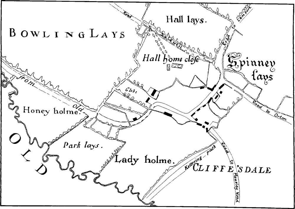
Fig. 94 Lamport (15, 16) Plan of Faxton in 1746 (from a map in NRO)
bd(16) Manor House Site (SP 783750; Figs. 93 and 94; Plates 6 and 7), lies immediately S.W. of the former village green of the deserted village of Faxton (15), on Boulder Clay at 130 m. above OD. The descent of the manor of Faxton is documented (VCH Northants., IV (1937), 167–171) but little is known of the manor house itself. In 1320 the buildings of the 'chief messuage' of the manor were said to have been in ruins (VCH, op. cit., 168). In the early 18th century Bridges (Hist. of Northants., II (1791), 92) noted that the 'ancient manor house' still remained and said that it was in being in the reign of Elizabeth I. He also recorded a gateway which bore the date of 1625 and an inscription referring to three members of the Nicolls family then holding the manor. By 1746 (NRO, Map of Faxton) the house had been demolished and the whole area was known as Hall Home Close.
The surviving remains, together with those planned by the OS before destruction and those visible on air photographs, indicate at least two separate phases. On the W. is a large L-shaped ditch up to 2.5 m. deep with both an internal and an external bank up to 1.25 m. high, and a causeway on the S. Beyond the causeway, the ditch and part of the bank continue, and beyond again is another oval depression to the S.E. These earthworks are now planted with conifers and difficult of access but they appear to be the N.W. half of a moated site within which the medieval manor house presumably once stood. To the E., and now completely destroyed, was a rectangular area bounded on the S. by a low bank and external ditch and probably on the W. by at least a bank. The parish church stood in the S.E. corner and from the N. side of the churchyard a low scarp extended N. to form the E. side of the area. The enclosure thus formed contained scarps and banks forming closes or perhaps garden plots; a very disturbed group of scarps in the centre were probably the remains of a building. The OS surveyors recorded two other embanked or scarped structures to the N., probably also former buildings. Beyond were other scarps and banks. This area was probably the site of the post-medieval manor house and its gardens recorded by Bridges. The house was possibly built by the Nicolls family who bought the manor of Faxton in 1606 and held it until the early 18th century. On the ground are large quantities of medieval and later pottery and stone rubble (RAF VAP CPE/UK/1925, 2323–4, 4367–8; CUAP, HAP74, AWVI–6, BAP87).
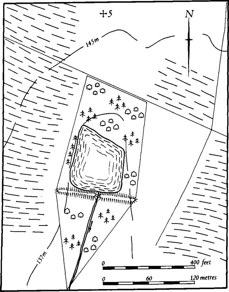
Fig. 95 Lamport (17) Dam
b(17) Dam (SP 774754; Fig. 95), lies N.W. of the deserted village of Faxton (15), across a small valley draining S. and cut into Jurassic Clay at 135 m. above OD. It was formerly in the parish of Faxton. It consists of a broad earthen bank up to 2.5 m. high with a modern gap in the centre. A small pond lies behind it but the original lake would have been at least twice as large. The pond is not shown on the 1746 map of Faxton (NRO), but on the Tithe Map of 1840 (NRO) both the pond and dam are carefully drawn (RAF VAP CPE/UK/1925, 4367–8).
b(18) Dam (SP 781753), lies between (17) and the deserted medieval village of Faxton (15), across a small S.-draining valley, on Jurassic Clay at 122 m. above OD. The broad earthen bank 2 m. high and 25 m. across formerly ponded back a small triangular lake. Like (17) above, the dam is not shown on the 1746 map of the parish (NRO) but both the dam and the lake are depicted on the 1840 Tithe Map (NRO; RAF VAP CPE/UK/1925, 4367–8).
(19) Cultivation Remains. The two medieval settlements of Lamport and of Hanging Houghton in the old parish of Lamport each had an open field system. The common fields of Lamport were enclosed by an Act of Parliament of 1795 and, though no Enclosure Map appears to have survived, a small plan of 1797 (in NRO) shows the boundary of three former fields. One lay to the N.E. of the village, another to the N.W., W. and S.W. and the third further W. between two S.-flowing streams. Ridge-and-furrow of these fields survives on the ground or can be traced on air photographs over large areas of this part of the parish. As a result of the very variable topography, with steep slopes and rounded spurs, the recoverable pattern is a complex one of interlocked and end-on furlongs, apparently carefully adapted to the natural drainage of the area. However even on the more gently sloping ground in the W. (SP 743748) the furlongs are arranged in a similar way.
The land immediately S.E. of Lamport Hall, now part of the park, apparently lay outside the common fields in 1797. Despite this there is much surviving ridge-and-furrow, especially to the S. of the hall around Swan Lodge (SP 758742). Further E., also in the park, there are large blocks of 18th or 19th-century narrow-rig ploughing, but this is overlying early headlands, now visible as broad ridges up to 25 m. wide but only a few centimetres high. The whole area therefore must have had ridge-and-furrow on it at an earlier date.
The date of the enclosure of the common fields of Hanging Houghton is not known but was certainly before 1655 (Map in NRO). Ridge-and-furrow of these fields survives on the ground or is visible on air photographs over wide areas and, especially in the S.W. of the parish, the pattern is almost complete and comprises end-on and interlocked furlongs carefully adapted to the natural topography. This is particularly well marked around the steep-sided Clint Hill (SP 746735) where the ridges radiate from the flat summit. Also in the S.W. of the parish, along the E. side of a small S.-flowing brook, are blocks of end-on furlongs separated by long headlands. On air photographs taken in 1947 one of these headlands, 1200 m. long and parallel to the stream (SP 739728–743740), is visible as a long, low ridge. More recent air photographs (in NMR), taken after the headland had been ploughed out, have revealed the cropmark of a double-ditched trackway or boundary, apparently under the headland, and visible for most of its length. At its S. end this trackway turns S.E., runs on beyond the end of the headland and passes between and parallel to the ridges of a furlong set obliquely to the others. These cropmarks, if indeed they do underlie the headland, may represent an earlier form of land boundary into which the common fields were fitted.
The common fields of the parish of Faxton were enclosed by Act of Parliament of 1743. Before that date there were apparently three open fields Nether, Upper and Middle Fields (VCH Northants., IV (1937), 170). Except in the extreme N. of the parish where an old airfield has destroyed much of the evidence, ridge-and-furrow exists on the ground or can be traced on air photographs over the whole area. It is arranged in end-on and interlocked furlongs, adapted to the natural topography as elsewhere, but it is characterized by an unusually large number of small rectangular furlongs with relatively short ridges between 80 m. and 100 m. long (RAF VAP CPE/UK/1925, 3223–4, 4376–8; CPE/UK/1994, 1376–82, 1453–61, 2447–9; 106G/UK/636, 4194–5).