An Inventory of the Historical Monuments in the County of Northamptonshire, Volume 3, Archaeological Sites in North-West Northamptonshire. Originally published by Her Majesty's Stationery Office, London, 1981.
This free content was digitised by double rekeying. All rights reserved.
'Stowe-Nine-Churches', in An Inventory of the Historical Monuments in the County of Northamptonshire, Volume 3, Archaeological Sites in North-West Northamptonshire(London, 1981), British History Online https://www.british-history.ac.uk/rchme/northants/vol3/pp179-182 [accessed 30 April 2025].
'Stowe-Nine-Churches', in An Inventory of the Historical Monuments in the County of Northamptonshire, Volume 3, Archaeological Sites in North-West Northamptonshire(London, 1981), British History Online, accessed April 30, 2025, https://www.british-history.ac.uk/rchme/northants/vol3/pp179-182.
"Stowe-Nine-Churches". An Inventory of the Historical Monuments in the County of Northamptonshire, Volume 3, Archaeological Sites in North-West Northamptonshire. (London, 1981), British History Online. Web. 30 April 2025. https://www.british-history.ac.uk/rchme/northants/vol3/pp179-182.
In this section
59 STOWE-NINE-CHURCHES
(OS 1: 10000a SP 65 NW, b SP 65 NE)
The parish, covering nearly 770 hectares, lies S.W. of Watling Street (A5) which forms its N.E. boundary. The W. and central part of the parish is occupied by a wide flat-topped plateau of Northampton Sand between 150 m. and 160 m. above OD. To the E. this plateau bifurcates to become two ridges on which stand the two villages of the parish, Church Stowe and Upper Stowe. From this higher area the land slopes N. and S. across Upper and Middle Lias Clay to two small E.-flowing streams which form the parish boundaries, between 90 m. and 105 m. above OD. To the E. of the village is a small outcrop of Great Oolitic Limestone, partly overlaid by glacial deposits.
The two villages, Upper Stowe and Church Stowe, lie about 1 km. apart near the E. edge of the parish and presumably in medieval times were surrounded by their common fields (12). Much of the N.W. part of the parish was occupied by at least one deer park (10); one length of the park boundary may have made use of an earlier multiple-ditch system (13), possibly of prehistoric date and associated with the occupation areas (2–8).
Prehistoric and Roman
a(1) Oval enclosure (SP 64835726), close to the Roman road, Watling Street, which here forms the parish boundary, on limestone at 115 m. above OD. Air photographs (in NMR) show a cropmark of a small oval enclosure about 40 m. long and 15 m. wide with at least one pit at its W. end. It has been interpreted as the site of a long barrow (BNFAS, 7 (1972), 57; Northants. Archaeol., 8 (1973), 26).
a(2) Ditched trackway, enclosure, pit alignment and ditches (centred SP 633564; Fig. 135), N.E. of Stowe Lodge, on Northampton Sand at 158 m. above OD. On air photographs (in NMR) cropmarks of a sinuous trackway (sp 63215627–63395653), orientated roughly S.W.–N.E. and visible for about 360 m., can be seen. To its W. there is part of a sub-rectangular enclosure with rounded corners (SP 63205635) and a short length of pit alignment. There are traces of other possible ditches and enclosures but these have been obscured by frost-wedging and are difficult to interpret.
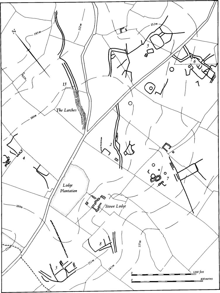
Fig. 135 Stowe-Nine-Churches (2–8, 13) Cropmarks
a(3) Enclosures, pit alignments and ditches (centred SP 626560; Fig. 135), 500 m. S.W. of (2), in the S.W. corner of the parish on Northampton Sand at 152 m. above OD. Air photographs (in NMR) show cropmarks of a sub-rectangular enclosure, of less than half a hectare (SP 62575602). To the E. three sides of another are visible, with two much smaller ones inside, towards the E. end. Traces of at least one other enclosure and ditches lie to the N. A curving ditch runs N.W. from the S.W. corner of the first enclosure; from the N.W. corner a short length of pit alignment runs N.N.E. A second, parallel alignment to the E. is more easily traced, over a longer distance (Northants. Archaeol., 9 (1974), 44).
a(4) Enclosures and ditches (SP 627567; Fig. 135), 450 m. N.W. of (2) on Northampton Sand at 159 m. above OD. Air photographs (in NMR) show cropmarks of two groups of small conjoined enclosures. Each cluster is associated with further ditches which may be parts of larger enclosures. Some 200 m. to the S. are other ditches (SP 628565).
a(5) Enclosure, ditches and ditched trackway (SP 637567; Fig. 135), 450 m. N.E. of (2), on Northampton Sand at 152 m. above OD. Air photographs (in NMR) show a sub-rectangular enclosure with slightly curved sides and rounded corners; it covers almost a hectare. To the N. there is a sinuous ditch running roughly E.–W. and traceable for about 180 m. A short distance to the E. are other ditches, and to the W. at least two small rectangular enclosures. Further W. is a length of ditched trackway which may be a continuation of that described in (2).
a(6) Enclosures and ditches (SP 640565; Fig. 135), immediately S.E. of (5), on Northampton Sand, at 145 m. above OD. Air photographs (in NMR) show an area of complex cropmarks which include part of a double-ditched enclosure, at least three ring ditches and a series of linear ditches or possible enclosures.
a(7) Enclosures, ring ditches and linear ditches (SP 634562; Fig. 135), lie S. of (2), on Northampton Sand, at about 150 m. above OD. Air photographs (in NMR) show a group of small rectangular enclosures, one bounded by a triple ditch and one by a double ditch. There are also at least three ring ditches to the N.E. Further S.E. is a series of linear ditches, perhaps part of a trackway, with a large enclosure and other ditches on its E. side.
a(8) Linear ditches (SP 629560; Fig. 135), E. of (3), on Northampton Sand, at 152 m. above OD. Air photographs (in NMR) show a small group of linear ditches.
b(9) Enclosure (SP 652568), in the E. of the parish, close to Watling Street, on Northampton Sand at 137 m. above OD. Air photographs (in NMR) show a small, sub-rectangular enclosure 15 m. by 30 m. with an entrance in its W. side (Northants. Archaeol., 8 (1973), 26).
For possible prehistoric linear earthwork, see (13).
For Roman Road 1f, Watling Street, see Appendix.
Medieval and Later
a(10) Deer park (centred SP 628579), perhaps occupied most of the N.W. part of the parish, mainly on Northampton Sand and Lias Clay, between 100 m. and 158 m. above OD. It is first mentioned in 1326 when Gilbert de Middleton was granted the manor of Stowe 'with the park' (Cal. Pat. 1324–7, 160). Its later history is unknown but Bridges (Hist. of Northants., I (1791), 88) records that in the late 17th century there were two contiguous parks, which had by his time 'been converted to other use'. He also notes that the area was formerly a warren. The exact extent of the park is unknown and the only traceable boundary features are not entirely convincing. There is no trace of any bank along the W. and N. parish boundaries. Along the N. side of the Farthingstone road, on the S. side of Ramsden Corner Wood (SP 62505626), there is a bank 5 m. wide and 0.5 m. high. A N.-facing scarp up to 2 m. high continues the line of the bank as far as Lodge Plantation (SP 62775638). There are no indications of a boundary between this point and the linear banks (13); the latter may be part of the boundary of the park.
Beyond the N. limit of these banks (SP 63305702) no trace of a boundary can be found. Two maps of 1773 and 1839 (NRO) give the name Parks to two fields S.E. of Stowe Wood (centred SP 630569). The 1839 map also names a field to the E. of the linear banks (SP 635572), and thus outside the assumed boundary, as Sheep Pen Parks.
a(11) Settlement remains (centred SP 604576 and 638576), formerly part of Church Stowe, lie in two places, W. and S.W. of the church. The first site consists of indeterminate earthworks and a small pond, and the second of a long scarp 120 m. long and about 1 m. high running S.W.–N.E. with other low earthworks on either side. In 1773 (Map in NRO) the area was already devoid of buildings though the main scarp was the boundary between two long rectangular paddocks (RAF VAP CPE/UK/1994, 1169–71).
(12) Cultivation remains. The exact date of the enclosure of the common fields of Stowe-Nine-Churches is not known but was certainly before 1773 (Map in NRO). Bridges (Hist. of Northants., I (1791), 87) records that the parish was enclosed by Edward Harley, apparently in the late 17th or early 18th century. Very little of the ridge-and-furrow of those fields survives or can be traced from air photographs. Apart from three fields at the head of a small valley between the two villages (SP 643571) the only areas where ridge-and-furrow survives in furlongs are along the S. boundary of the parish where the ridges run down to the stream and to the S. of Upper Stowe where there is a group of interlocked furlongs (RAF VAP CPE/UK/1994, 3158–62, 1167–72, 2164–6).
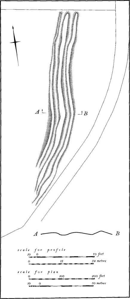
Fig. 136 Stowe-Nine-Churches (13) Linear banks and ditches
Undated
a(13) Linear banks and ditches (centred SP 63255670; Figs. 135 and 136), on Northampton Sand between 150 m. and 160 m. above OD. The earthwork consists of three parallel banks orientated S.S.W. to N.N.E., separated by shallow U-shaped ditches. The average total width is about 25 m. and the earthworks extend for 220 m. The E. bank, which is the largest, reaches a maximum of 1.5 m. above the bottom of the adjacent ditch. There are four causeways across the banks and ditches, all probably secondary. At its S.W. end the earthwork turns and fades, apparently respecting the modern road and this might suggest that it is later than the road. No trace of a S.W. continuation is visible, however, as a disused ironstone tramway has destroyed any remains. To the N.E. air photographs (in NMR) show cropmarks of three parallel ditches, extending the alignment of the earthworks for at least 180 m. These ditches are then either intersected by or continued as two parallel ditches which run N.E. for a further 300 m.
Despite a small excavation in 1973 there is no conclusive evidence as to the function or date of the structure. It may be medieval or later and could have been part of the boundary of the deer park (10), or a warren for rabbits, though its size and form makes this doubtful. It has also been suggested that it is spoil from quarrying or a 19th-century military work for cannon associated with Weedon Barracks, but these alternatives are also unlikely (OS Record Cards; BNFAS, 5 (1971), 42; Northants. Archaeol., 8 (1973), 27; RAF VAP CPE/UK/1994, 3159–60). A more acceptable explanation is that the earthworks are part of a linear boundary of prehistoric date, and thus a rare survival in the county; they may have been reused as the deer park boundary.