An Inventory of the Historical Monuments in the County of Northamptonshire, Volume 3, Archaeological Sites in North-West Northamptonshire. Originally published by Her Majesty's Stationery Office, London, 1981.
This free content was digitised by double rekeying. All rights reserved.
'Clipston', in An Inventory of the Historical Monuments in the County of Northamptonshire, Volume 3, Archaeological Sites in North-West Northamptonshire( London, 1981), British History Online https://www.british-history.ac.uk/rchme/northants/vol3/pp49-51 [accessed 27 July 2024].
'Clipston', in An Inventory of the Historical Monuments in the County of Northamptonshire, Volume 3, Archaeological Sites in North-West Northamptonshire( London, 1981), British History Online, accessed July 27, 2024, https://www.british-history.ac.uk/rchme/northants/vol3/pp49-51.
"Clipston". An Inventory of the Historical Monuments in the County of Northamptonshire, Volume 3, Archaeological Sites in North-West Northamptonshire. (London, 1981), , British History Online. Web. 27 July 2024. https://www.british-history.ac.uk/rchme/northants/vol3/pp49-51.
In this section
18 CLIPSTON
(OS 1: 10000 a SP 78 SW, b SP 77 NW, c SP 68 SE, d SP 67 NE)
The diamond-shaped parish occupies 1185 hectares, across the head-waters of the R. Ise and several small tributary streams. The latter have cut down into the Boulder Clay which covers the higher ground between 135 m. and 180 m. above OD, to reveal bands of Upper Lias Clay along the steep valley sides. As well as four recently discovered small Roman settlements the parish contains two important medieval monuments. The extensive settlement remains (7) which lie within and to the W. of Clipston itself indicate that the development of the village has been very complex. The deserted village of Nobold or Newbold (6) lies in the N.W. of the parish but the boundaries of its land cannot be ascertained.
Roman
a(1) Roman settlement (?) (SP 701806), lies S.W. of the village on gravel at 145 m. above OD. A small quantity of Roman pottery has been found here (Northants. Archaeol., 11 (1976), 191).
c(2) Roman settlement (?) (SP 695805), lies W. of (1) on Boulder Clay at 150 m. above OD. A scatter of Roman pottery has been found in the area around an abandoned farm-house (Northants. Archaeol., 11 (1976), 191).
c(3) Roman settlement (?) (SP 697828), lies N.W. of the village, on Boulder Clay, at 150 m. above OD. A scatter of Roman pottery has been discovered (Northants. Archaeol., 12 (1977), 211).
a(4) Roman settlement (?) (SP 714830), lies N. of the village, on Boulder Clay, at 150 m. above OD. A scatter of Roman pottery is recorded here (Northants. Archaeol., 12 (1977), 211).
Medieval and Later
The site of the deserted settlement of Calme, which is only known from Domesday Book where it is listed with a recorded population of five (VCH Northants., I (1902), 318), has not been located (K. J. Allison et al., The Deserted Villages of Northants. (1966), 36). The most likely position for it is in the extreme N. of the parish near Twantry Farm (SP 702840). A number of fields in this area have the name Comb (NRO, Field Name Map, 1932) but no remains have been found.
During the 19th century a skeleton, accompanied by a spear, an arrowhead or spear and a spur said to be of the 15th century, is recorded as being found in the parish (Trans. Leics. Arch. Soc., 2 (1870), 354). It is possible that this refers to the Saxon burial (5).
a(5) Saxon burial (SP 714815), perhaps in the S.E. part of the village, on clay at 126 m. above OD. One skeleton was discovered in 1867, accompanied by a knife, a scramasax and part of a spearhead of Swanton's type C2 (M. J. Swanton, The Spearheads of the Anglo-Saxon Settlements (1973), 157; BAR, 7 (1972), 42; VCH Northants., I (1902), 237; T. J. George, Arch. Survey of Northants. (1904), 12; Meaney, Gazetteer, 188; J. Northants. Mus. and Art Gall., 6 (1969), 49).
c(6) Deserted village of Nobold (SP 695821; Fig. 44; Plate 10), lies on the E.-facing slope of a high N.–S. ridge in the extreme N.W. of the parish, against the Sibbertoft boundary, on Boulder Clay at 165 m. above OD. Little is known of the history of the village and its name is not recorded until 1284 when it had 35 virgates of land divided between three manors. The meaning of its name 'New Building', as well as the site of the village, suggests that it was a later secondary settlement of Clipston (PN Northants., 111). Nobold is rarely named in the national taxation records and is presumably included with Clipston. It is mentioned by name in the Nomina Villarum of 1316, and in 1381 its three common fields are noted and tenants are recorded in the largest of the manors. By 1459 only two houses existed in this manor though nothing is known of the situation on the other two manors. The only certainty is that the village was totally deserted by the early 18th century and had been so for a long time. Bridges (Hist. of Northants., II (1791), 23–4) gives a long description of the earthworks lying in a field known as Old Nobold Close. He recognized the central hollow-way of the main street and recorded the house-sites on both sides of it. He also noted that 'In one part is a plot of ground immemorially called the church-yard. ... Human skulls have been dug up here' (K. J. Allison et al., The Deserted Villages of Northants. (1966), 43; J. M. Steane, The Northants. Landscape (1974), 160–2).
The remains are in good condition except that, like other deserted villages in the area, e.g. Onley (Barby (1)), Glassthorpe (Flore (4)) and Sulby (3), the site has been almost completely overploughed with ridge-and-furrow at some time after desertion. The main feature of the site is a broad hollow-way up to 1.5 m. deep which crosses the site from E.–W. but is blocked at its W. end partly by later ridge-and-furrow and partly by a relatively modern ditch. On both sides of this hollow-way are the remains of platforms set within small embanked or scarped yards. These are well preserved at the E. end of the hollow-way, on its N. side, but all those on the S. are very broken down by later ridge-and-furrow, and those on the N. side towards the W. end have been completely obliterated by the plough. Behind the sites of houses and yards there are traces of long closes, but again ploughing has almost entirely destroyed them.
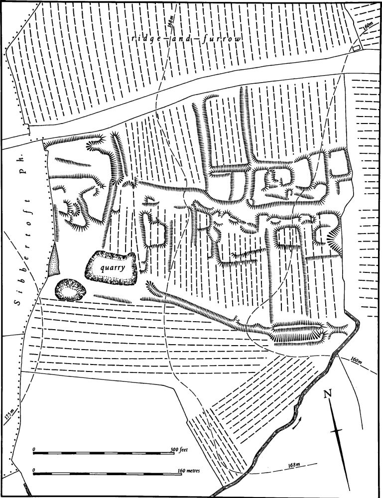
Fig. 44 Clipston (6) Deserted village of Nobold
One small area of earthworks at the W. end, beyond the blocking of the hollow-way, has no trace of ridge-and-furrow, but this too has been ploughed over, at a later date than the ridge-and-furrow, and thus the remaining earthworks are indistinct. In the S.E. corner of the site is a small rectangular embanked pond which is approached from the W. by a narrow ditch (RAF VAP 106G/UK/636, 3182–3).
a(7) Settlement remains (centred SP 706818; Figs. 11 and 45), lie within and around the existing village between 130 m. and 150 m. above OD. The size of Clipston village at any one time is impossible to ascertain because the parish also included the now deserted village of Nobold (6) and both settlements were always recorded together. However the village was presumably always large for in Domesday Book there are four manors listed for Clipston, three of which have a combined recorded population of 41, though the fourth, part of the royal manor of Rothwell, has no separate population figures (VCH Northants., I (1902), 306, 310, 318, 337). In 1377, 119 people over the age of 14, most of whom lived at Clipston, paid the Poll Tax (PRO, E179/155/28). In 1674, 48 householders paid the Hearth Tax, all of whom were probably from Clipston, Nobold by then having been abandoned; in addition two 'empty ruined town houses' and two empty cottages are recorded (PRO, E179/254/14). Bridges (Hist. of Northants., II (1791), 17) said that 120 families lived at Clipston in the early 18th century. In 1801, 331 people lived in the parish.
The main significance of the settlement remains is that they indicate the complicated evolution of the village's morphology, and a tentative sequence can be inferred from the modern layout and the surviving earthworks. It is possible that the earliest part of the village was the area around High Street and Church Lane, centred on the church in which there is some evidence of a 12th-century structure. The Saxon burial (5) was perhaps found hereabouts.
The second stage of development may have been a planned extension in the N.W., comprising three parallel streets, with the village green in the S.E. corner. Two of these streets survive as Chapel Lane and Harborough Road, and the third which lies equidistant between them is a broad hollow-way up to 2.5 m. deep ('a'–'b' on plan). On both sides of this hollow-way, on the E. side of Chapel Lane ('c' on plan) and on both sides of Harborough Road ('d' and 'e' on plan) there are closes of former houses, bounded by shallow ditches or low banks and scarps.
Later expansion may have been in the area S.W. of Chapel Lane where there are extensive settlement remains apparently based on two hollow-ways. One of the latter extends from the bend in Pegs Lane ('f' on plan) and runs N.W. until it meets the other, which is longer and curves S.E. and then S.W. ('g'–'h' on plan). Pegs Lane itself may be part of this development. On both sides of these hollow-ways are many small closes, some with identifiable house-sites within them.
Elsewhere in the village are small areas of old embanked closes (not shown on plan) which do not appear to have been occupied by dwellings. One such area lies immediately N. of the church (SP 714817; RAF VAP CPE/UK/2109, 3291–5, 4293–5; CUAP, AHE83–4, BAP74).
(8) Cultivation remains. The common fields of Clipston and Nobold were apparently enclosed by an Act of Parliament in 1776, but it is not clear whether all the land previously belonging to Nobold was affected. Some of the ridge-and-furrow of these fields has been destroyed but most of it survives or can be traced on air photographs, and much of it is of considerable size and well preserved. Such areas lie both around Clipston village and around the deserted village of Nobold and also in the S. part of the parish. The furlongs are often short and interlocked in response to the broken nature of the landscape, particularly W. and N. of the village, but there are also groups of end-on furlongs, for example S. of Nobold (SP 698817), N. of the Sibbertoft road (SP 750825) and S.E. of the village (SP 716810). The deserted village of Nobold has been completely overploughed with ridge-and-furrow, perhaps of post-medieval date (RAF VAP 106G/UK/636, 4130–33, 3128–33, 3182–86, 4460–3; CPE/UK/2109, 4293–8, 3291–9).