An Inventory of the Historical Monuments in the County of Northamptonshire, Volume 3, Archaeological Sites in North-West Northamptonshire. Originally published by Her Majesty's Stationery Office, London, 1981.
This free content was digitised by double rekeying. All rights reserved.
'Crick', in An Inventory of the Historical Monuments in the County of Northamptonshire, Volume 3, Archaeological Sites in North-West Northamptonshire(London, 1981), British History Online https://www.british-history.ac.uk/rchme/northants/vol3/pp60-62 [accessed 30 April 2025].
'Crick', in An Inventory of the Historical Monuments in the County of Northamptonshire, Volume 3, Archaeological Sites in North-West Northamptonshire(London, 1981), British History Online, accessed April 30, 2025, https://www.british-history.ac.uk/rchme/northants/vol3/pp60-62.
"Crick". An Inventory of the Historical Monuments in the County of Northamptonshire, Volume 3, Archaeological Sites in North-West Northamptonshire. (London, 1981), British History Online. Web. 30 April 2025. https://www.british-history.ac.uk/rchme/northants/vol3/pp60-62.
In this section
22 CRICK
(OS 1: 10000 a SP 57 SE, b SP 67 SW)
The parish, covering nearly 1340 hectares, is E. of Watling Street which forms its W. boundary. It lies mainly on undulating clayland between 100 m. and 160 m. above OD, drained by a series of small streams flowing N.W. to the R. Avon. The settlement remains (7), which contribute much towards an understanding of the village's development, constitute the main monument in the parish.
Prehistoric and Roman
A silver coin of Hadrian was found at Crick before 1712 (J. Morton, Nat. Hist. of Northants. (1712), 532).
a(1) Enclosure (SP 584710), in the S.W. of the parish on Boulder Clay at 144 m. above OD. Air photographs (not seen by RCHM) are said to show a small rectangular ditched enclosure (Northants. Archaeol., 12 (1977), 229).
a(2) Iron Age settlement (?) (SP 581714), S.W. of the village and immediately E. of the M1, on Middle Lias Clay at 135 m. above OD. Iron Age pottery, burnt stone and dark soil have been found here (CBA Group 9, Newsletter, 7 (1977), 29; Northants. Archaeol., 11 (1976), 183).
a(3) Roman settlement (?) (SP 587725; Fig. 53), within Crick village, N.W. of the church, on glacial gravel at 130 m. above OD. Roman pottery is recorded from this area (CBA Group 9, Newsletter, 7 (1977), 29).
a(4) Roman settlement (?) (SP 577733), W. of the village, on the E. side of the M1, on glacial gravel at 120 m. above OD. Roman pottery and building stone have been found on the edge of the motorway cutting which probably destroyed the rest of the site (CBA Group 9, Newsletter, 7 (1977), 29; Northants. Archaeol., 11 (1976), 191).
a(5) Roman settlement (?) (SP 581734), 500 m. E.N.E. of (4), on glacial gravel at 120 m. above OD. Roman pottery has been found in this area (CBA Group 9, Newsletter, 7 (1977), 29; Northants. Archaeol., 11 (1976), 191).
For Roman Road 1f, Watling Street, see Appendix.
Medieval and Later
In the early part of the 18th century it was recorded that in 'a part of the Lordship called Portlow are several eminences which have the appearance of tumuli' (J. Bridges, Hist. of Northants., I (1791), 558). No trace of these can now be seen.
a(6) Saxon burials (?) (SP 569732), in the Roman road, on the W. boundary of the parish, on alluvium at 106 m. above OD. When a section was cut across the road in 1947 a female skeleton, lying on its back and orientated E.–W., was discovered buried at the centre of the road. A second pit some 1.75 m. to the N. contained a small human skull, and the skeleton of a dog. There were no grave goods, except perhaps for two pieces of belemnite found close to the human skeleton (Rugby School Magazine (1948), 34–7). More recently another burial, said to be Saxon, was discovered during roadworks on the modern A5 a little to the N.E. and E. of the Roman road (SP 568734; CBA Group 9, Newsletter, 7 (1977), 29). Saxon cemeteries have been found on Watling Street a few miles to both N. and S. and these remains are perhaps of the same period (see Norton (9)).
a(7) Settlement remains (SP 589726; Fig. 53), formerly part of Crick village, lie immediately N.E. and E. of the church, on land sloping gently N.E., at about 133 m. above OD. The earthworks are not impressive, for they consist only of a series of long closes bounded either by low scarps or by modern hedge-banks. Most of these have ridge-and-furrow within them which, in some cases at least, is secondary. Two hollow-ways pass between them. A disturbed area at their S.W. ends shows no recognisable features.
The date of abandonment of these remains is unknown though it is possible that the 'wasting' of two halls, a cottage and a 'sheepscote' carried out in 1380 by one Andrew Gyldford who then 'had the keeping of the manor of Crick ... owing to the minority of the ... Earl (of Nottingham)' may relate to this area (Cal Inq. Misc. iv, 123).
The existence of the earthworks perhaps throws some light on the origins of the village's layout as it is now. The modern street plan of Crick consists of a peculiar arrangement of loops on either side of the present main E.–W. road. However if the earthworks noted here are interpreted as former house-sites and closes along an old N.W.–S.E. road approximately followed by the present footpath, then it can be postulated that the village originated along two roughly parallel streets running S.E.–N.W. The westernmost of these was on the present High Street–Church Street alignment which possibly continued N.W. from the bend in the Yelvertoft road. The other street, to the E., would have been along Laud's Road and The Marsh, and across The Green then through the earthworks and around the E. end of Oak Lane and finally along Drayson Lane into the Yelvertoft Road (Air photographs in NMR).
a(8) Fishponds (SP 591720), on the S. side of the village, S. of Boat Horse Lane on Middle Lias Clay at 140 m. above OD. Two rectangular depressions lying parallel to each other and 0.5 m. deep are probably medieval fishponds. There are traces of later ridge-and-furrow lying within them (CBA Group 9, Newsletter, 7 (1977), 29).
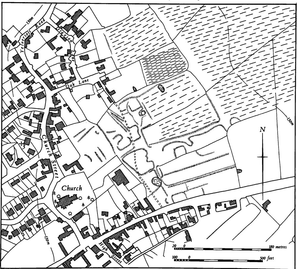
Fig. 53 Crick (3) Roman settlement, (7) Medieval settlement remains
a(9) Windmill mound (SP 59157188), S. of the village, on Middle Lias Clay at 152 m. above OD. A low mound 1 m. high and 12 m. in diam. is the site of a windmill which still existed in the early 19th century (OS 1st ed. 1 in. map (1834); CBA Group 9, Newsletter, 7 (1977), 29).
(10) Cultivation remains. The common fields of the parish were enclosed by an Act of Parliament of 1776. Ridge-and-furrow of these fields exists on the ground or can be traced on air photographs over most of the parish so that the original pattern is almost wholly recoverable. It is arranged mainly in rectangular interlocked furlongs though on the steep slopes, around Crack's Hill for example (SP 595735), it lies across the contours in a radiating pattern. The ridges are still exceptionally well preserved in many places, especially N. and S. of the village (e.g. at SP 590734 and 589715), and as a result a number of details which have been destroyed elsewhere are still visible. In a few places two end-on furlongs have been thrown together and ploughed as one. A particularly good example lies N.W. of the village (SP 584735) where two curving end-on furlongs have been joined up, thus producing a double bend in the ridges as they cross the original headland. Elsewhere hollow trackways through the fields still exist (e.g. SP 582715). Examples also occur of double headlands; the original headland has been abandoned, perhaps to provide extra pasture at some time, and the plough, turning 10 m.–15 m. short of this, has created a new headland. These occur S.W. and S.E. of the village (SP 582720 and 595715). Another feature of the ridge-and-furrow here is the existence of small shallow quarry pits, probably for gravel, which have been dug through the earlier ridge-and-furrow but have subsequently been reploughed in ridges (e.g. SP 584715; CBA Group 9, Newsletter, 6 (1976), 28; 7 (1977), 29; RAF VAP CPE/UK/1994, 1356–61, 1474–9, 1472–7; 106G/UK/636, 3440–1, 4441–4; 541/15, 4378–83).