An Inventory of the Historical Monuments in the County of Northamptonshire, Volume 3, Archaeological Sites in North-West Northamptonshire. Originally published by Her Majesty's Stationery Office, London, 1981.
This free content was digitised by double rekeying. All rights reserved.
'Harlestone', in An Inventory of the Historical Monuments in the County of Northamptonshire, Volume 3, Archaeological Sites in North-West Northamptonshire(London, 1981), British History Online https://www.british-history.ac.uk/rchme/northants/vol3/pp97-100 [accessed 30 April 2025].
'Harlestone', in An Inventory of the Historical Monuments in the County of Northamptonshire, Volume 3, Archaeological Sites in North-West Northamptonshire(London, 1981), British History Online, accessed April 30, 2025, https://www.british-history.ac.uk/rchme/northants/vol3/pp97-100.
"Harlestone". An Inventory of the Historical Monuments in the County of Northamptonshire, Volume 3, Archaeological Sites in North-West Northamptonshire. (London, 1981), British History Online. Web. 30 April 2025. https://www.british-history.ac.uk/rchme/northants/vol3/pp97-100.
In this section
35 HARLESTONE
(OS 1: 10000 a SP 66 NE, b SP 66 SE, c SP 76 NW, d SP 76 SW)
The parish covers some 1040 hectares and lies immediately N.W. of Northampton. Most of it is a fairly flat tableland of Northampton Sand between 90 m. and 105 m. above OD, but the down-cutting of a number of small streams has exposed the Jurassic Clay and in the S. there is an area of limestone and Marlstone overlaid by Boulder Clay. Many prehistoric and Roman sites are recorded. However this probably reflects not an unusually rich settlement history but simply the relative ease of recognition of cropmarks on the Northampton Sand.
Prehistoric and Roman
A Roman urn is said to have been found in the parish before 1904 (T. J. George, Arch. Survey of Northants. (1904), 15), and a coin of Constantine I was discovered in 1976 at SP 686638 (Northants. Archaeol., 12 (1977), 212).
The ring ditches (centred SP 694651), in the N.W. of the parish on Northampton Sand at 122 m. above OD and visible on air photographs (CUAP, ABG29) are anti-aircraft sites and are still visible as earthworks on photographs taken in 1947 (RAF VAP CPE/UK/1994, 4369–70; see also Brixworth and Brockhall).
They lie on each side of a broad access-way between ridge-and-furrow, which, having been ploughed out, appears as a ditched trackway. (For Saxon material from this field, see (11)).
c(1) East Harlestone complex (centred SP 711652; Fig. 76), covers some 24 hectares in the N.E. of the parish, on Northampton Sand between 75 m. and 100 m. above OD. Air photographs (in NMR and CUAP, AFX19, 20, ADP5, 7, 8, ZU71–74, ZV27, 28) show a complicated series of ditches, enclosures and trackways extending over at least seven fields on either side of the road from Harlestone to Church Brampton.
A ditched trackway orientated roughly E.–W. and traceable for 900 m. runs from SP 70686526 to 71566506 through the middle of the visible remains. A ditch to the N. which may represent another track or the sides of rectangular enclosures, runs from the trackway to SP 71336545 where it intersects another length of ditch, perhaps a boundary. Between this last ditch and the trackway is a series of rectangular and irregular conjoined enclosures of varying size. A short length of pit alignment is visible (from SP 71016541 to SP 71146540). To the S. of the main trackway and intersecting one of its ditches is a large ring ditch (centred SP 71056515) about 60 m. in diam. with an entrance on its E. side; S. and S.W. of this there are at least 18 smaller ring ditches, of which about half lie within two large rectangular enclosures each more than 1 hectare in area. One of these (centred SP 70886498) has numerous subdivisions and other internal features. The other (centred SP 71056498) appears to be bounded by two or sometimes three ditches.
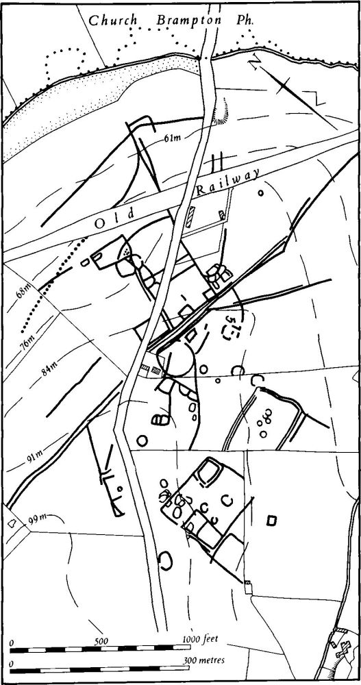
Fig. 76 Harlestone (1) East Harlestone Complex
d(2) Enclosure (SP 703627), lies in the S. of the parish, on limestone, at 99 m. above OD. Air photographs (in NMR) show the cropmarks of a small trapezoidal enclosure 0.3 hectares in area. No interior features or entrances are visible. It may be associated with other enclosures to the S.E. in Harpole parish (see RCHM Northants., IV (forthcoming)).
d(3) Pit alignment (SP 709630), close to the S. parish boundary, on Northampton Sand, at 100 m. above OD. Air photographs (in NMR) show a pit alignment visible for some 225 m., running in a broad curve generally S.W.–N.E.
d(4) Linear ditches (SP 710639–715646; Fig. 77), lie S.E. of Lower Harlestone, on Northampton Sand between 83 m. and 100 m. above OD, alongside a small N.E.-flowing stream cut down into Upper Lias Clay. The feature consists of three parallel ditches visible on air photographs (in NMR) for a distance of 870 m. The outer ditches are slightly wider than the central one and the latter is closer to the E. ditch than the W. Near the S.W. end, the W. ditch appears to curve S.E. and merge with the central one. To the N.W. are two intersecting linear ditches which have previously been described as a large enclosure. Worked flints have been found there (BNFAS, 6 (1971), 13, Harlestone (2)).
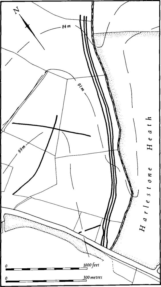
Fig. 77 Harlestone (4) Linear ditches
d(5) Pit alignments and ditches (centred SP 716634; Fig. 78), lie in the S.E. of the parish, S. of Harlestone Heath, on Northampton Sand, at 93 m. above OD. Air photographs (in NMR) show two short lengths of pit alignment roughly parallel to each other and 350 m. apart. An L-shaped feature, possibly the corner of a double-ditched enclosure, lies between them. The northernmost pit alignment may be a continuation of another visible further E. within Northampton (see RCHM Northants., V (forthcoming)).
d(6) Mound (SP 716636), in the S.E. of the parish, on Harlestone Heath, on Northampton Sand, at 90 m. above OD. The mound is 1 m. high and 7 m. in diam. and may be a barrow (BNFAS, 3 (1969), 1).
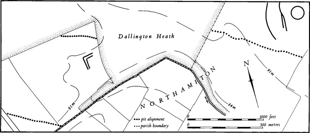
Fig. 78 Harlestone (5) Cropmarks
b(7) Roman settlement (SP 698639), in Upper Harlestone village, on Northampton Sand, at 95 m. above OD. Cropmarks are said to have been seen in 1963 and sherds of Roman grey ware have been found (BNFAS, 6 (1971), 13, Harlestone (3)).
b(8) Roman settlement (SP 69456376), 350 m. W.S.W. of (7) and in a similar position. Roman grey wares and 4th-century Nene Valley wares have been found (OS Record Cards).
b(9) Roman settlement (SP 69386345), 200 m. S. of (5) and in a similar position. Nene Valley wares and 2nd-century grey wares have been found, as well as iron slag (OS Record Cards).
b(10) Roman building (SP 68196330), in Sharaoh Field, in the W. of the parish, on Boulder Clay at about 117 m. above OD. A large Roman building was excavated in 1927–9. Foundations of stone walls and remains of a hearth were found, as well as samian and coarse Roman wares which show that the site was occupied from the 2nd to the 4th century. A hoard of 814 Roman coins, dating from 164 to 395 A.D. and which had been buried on the site after the building was in ruins, was also found (JRS, 17 (1927), 202; Num. Chron., 10 (1930), 275; 11 (1931), 231; Ass. Arch. Soc. Reps., 40 (1933), 299–308; Arch. J., 90 (1933), 282–305; BAR, 40 (1977), 63; OS Record Cards). A bronze coin of Magnentius and a scatter of building-stone were discovered in the same field in 1970 (BNFAS, 5 (1971), 44). The site may be the one referred to by Bridges (Hist. of Northants., I (1791), 511); 'at a small distance from Newbottle Wood are marks of an ancient building with several ruinous walks leading to it'.
For Roman Road 17, see Appendix.
Medieval and Later
a(11) Saxon settlement (SP 693653), on Northampton Sand, at 115 m. above OD. During house-building in 1959 part of a Saxon loom weight and nine sherds of gritty Saxon pottery were found with bones, black earth and a possible hearth. One sherd of Roman pottery was also discovered (BNFAS, 5 (1971), 45).
b(12) Quarries (e.g. SP 695641, 705640, 708638). In the centre of the parish, around and to the S. of the village, are several large quarry pits, dug into the underlying Northampton Sand. Most are of post-medieval date, but others are probably much older and Morton (Hist. of Northants. (1712), 110) recorded some of them as 'very ancient'.
(13) Cultivation remains. The common fields of the parish were enclosed by an Act of Parliament of 1766 (Notes on Enclosure in Northants., Central Library, Northampton); no map appears to have survived. Ridge- and-furrow of these fields is visible on the ground or can be traced on air photographs over much of the parish, arranged in end-on and interlocked furlongs. It is particularly well preserved in parts of Harlestone Park (SP 698643; RAF VAP CPE/UK/1994, 2249–58, 3246–52, 4256–9, 4367–72).
Undated
(14) Earthworks and burials (unlocated). Bridges, writing about 1720 (Hist. of Northants., I (1791), 511), records that 'on a place called Dive's-heath are the remains of a fortification where human skulls and bones have often been dug up'. The location and date of this site is unknown.