An Inventory of the Historical Monuments in the County of Northamptonshire, Volume 4, Archaeological Sites in South-West Northamptonshire. Originally published by Her Majesty's Stationery Office, London, 1982.
This free content was digitised by double rekeying. All rights reserved.
'Syresham', in An Inventory of the Historical Monuments in the County of Northamptonshire, Volume 4, Archaeological Sites in South-West Northamptonshire(London, 1982), British History Online https://www.british-history.ac.uk/rchme/northants/vol4/pp141-143 [accessed 30 April 2025].
'Syresham', in An Inventory of the Historical Monuments in the County of Northamptonshire, Volume 4, Archaeological Sites in South-West Northamptonshire(London, 1982), British History Online, accessed April 30, 2025, https://www.british-history.ac.uk/rchme/northants/vol4/pp141-143.
"Syresham". An Inventory of the Historical Monuments in the County of Northamptonshire, Volume 4, Archaeological Sites in South-West Northamptonshire. (London, 1982), British History Online. Web. 30 April 2025. https://www.british-history.ac.uk/rchme/northants/vol4/pp141-143.
In this section
57 SYRESHAM
(OS 1:10000 a SP 64 SW, b SP 64 SE, c SP 63 NW)
The parish is large, covering more than 1500 hectares, and includes the medieval settlements of Syresham itself (2) and of Crowfield (4). It slopes gently from 145 m. above OD in the N. to 115 m. above OD in the S., drained by a central S.-flowing stream and its tributaries. Most of the area is covered by Boulder Clay, but there are glacial sands and gravels around the main village and Oolitic limestones are exposed along the valleys of the central stream and of an E.-flowing one which forms part of the S. boundary. The area is heavily wooded in the E., being part of the former Whittlewood Forest; until the post-medieval period this forest extended further W., almost to Syresham village (NRO, maps of Whittlewood Forest; Fig. 16).
Roman
a(1) Roman Kilns (?) (SP 632421), immediately N.E. of the village, on gravel at 134 m. above OD. 'Two small ovens' apparently associated with Roman pottery were discovered in 1926 (JRS, 16 (1926), 223; Northants. SMR).
Medieval and Later
For deer park in the N.W. of the parish, see Helmdon (12)
a(2) Settlement Remains (SP 628418 and 630416; Fig. 12 and partly on Fig. 109), formerly part of Syresham, lie in two places. The village consists of two separate parts on either side of a small valley. On the S. side is the main part, based on an oval street system; to the N. is a smaller area known as Church End, with the parish church on its E. side. The dual character of the village is perhaps a reflection of the manorial history. Domesday Book (VCH Northants., I (1902). 324, 330 and 344–5) records three manors, one probably Crowfield and the others the two parts of Syresham.
The earthworks in the W. part of Church End (SP 628418) have mostly been destroyed by a modern housing estate and only a few fragmentary banks and scarps now exist. In the S. part of the village (SP 630416) a rectangular enclosure 50 m. by 30 m. orientated E.-W. and bounded by a low bank and ditch still remains. It is possibly an old paddock. (RAF VAP CPE/UK/1926, 5225–7)
a(3) Fishpond (SP 630417; Figs. 12 and 109), lies in the valley of a small E.N.E.-flowing stream, on clay and alluvium at 142 m. above OD. A large irregular pond is cut down into the valley sides with a large dam now much damaged at its N.E. end. The N. and S. sides have large banks 1 m.-2 m. high separating the pond from two high-level leats. The leat on the N. appears to have been an overflow channel to carry water round the pond, and the leat to the S. leads to the site of a watermill which lay immediately S.E. of the dam. Nothing is known of the history or date of this pond. (RAF VAP CPE/UK/1926, 5225– 7)
a(4) Settlement Remains (SP 616416), formerly part of the hamlet of Crowfield, lie to the S.W. of the existing hamlet, in the W. of the parish, on Boulder Clay at 137 m. above OD. The name Crowfield is not apparently recorded in documents until 1287 (PN Northants., 60) but it is likely that it is one of the three manors listed under Syresham in Domesday Book, perhaps the small half-hide holding with a single villein (VCH Northants., I (1902), 324). The remains are visible on air photographs taken in 1947 (RAF VAP CPE/UK/1926, 5224–5; air photographs in NMR) but the area has now been partly levelled by ploughing and returned to permanent grassland. The air photographs show at least four long rectangular closes bounded by low banks and shallow ditches, extending E. from the N.-S. road S.W. of the hamlet. They had been ploughed over in slight, narrow ridge-and-furrow.
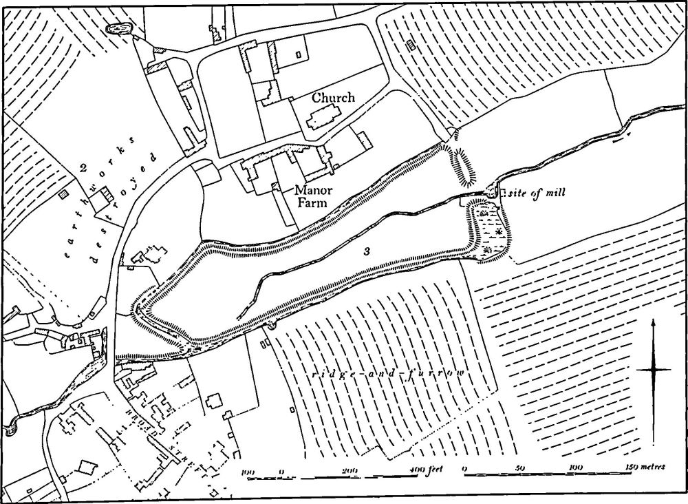
Fig. 109 Syresham (2) Settlement remains, (3) Fishpond
a(5) Ditches (SP 636420–638415), perhaps part of a former watermill, lie immediately S.W. of Kingshill Farm, on the E. side of a small S.E.-flowing stream, on glacial deposits at 122 m. above OD. Two almost parallel ditches 7 m. wide and up to 1.5 m. deep run from a sharp bend in the stream N.W. of the farm, in a curve parallel to the stream for a distance of 300 m. to a point just S. of the farm. The lower ditch then turns W. and returns to the stream; the other continues S.E. for a further 100 m. before fading out. (Air photographs in NMR)
(6) Cultivation Remains. The common fields of the parish were enclosed by an Act of Parliament of 1765. No details are known except that there were already 460 acres of old enclosures at that time (G. Baker, Hist. of Northants., I (1822–30), 676), and it is uncertain whether Crowfield hamlet had a separate field system. Ridge-and-furrow of these fields exists on the ground or can be traced on air photographs over much of the parish except in the extensive areas of woodland or former woodland. It is mostly arranged in end-on and interlocked furlongs, many of reversed-S form, and is still especially well preserved in the area between Syresham village and the county boundary to the S. (around SP 632405). Among the more notable features are well-marked hollow-ways cut into headlands and leading into the fields from the village (e.g. SP 626417), small embanked enclosures of up to 2 hectares lying over earlier ridge-and-furrow (e.g. SP 633416), and headlands which have been overploughed in ridge-and-furrow (e.g. SP 633421). The N.W. of the parish appears to have been part of the deer park (Helmdon (12)) and very little ridge-and-furrow is visible there. (RAF VAP CPE/UK/1926, 2224–30, 3226–8, 5222–30)
Undated
a(7) Site of Building (about SP 638418), E. of the village, in the vicinity of Kingshill. Bridges (Hist. of Northants., I (1791), 243–4), writing in about 1720, said that somewhere to the W. of Kingshill '. . . have been found in plowing stones and foundations of buildings. And there are reports of other large stones and ruins . . . there abouts'. The site has not been located.