An Inventory of the Historical Monuments in the County of Northamptonshire, Volume 4, Archaeological Sites in South-West Northamptonshire. Originally published by Her Majesty's Stationery Office, London, 1982.
This free content was digitised by double rekeying. All rights reserved.
'Thorpe Mandeville', in An Inventory of the Historical Monuments in the County of Northamptonshire, Volume 4, Archaeological Sites in South-West Northamptonshire(London, 1982), British History Online https://www.british-history.ac.uk/rchme/northants/vol4/pp145-148 [accessed 30 April 2025].
'Thorpe Mandeville', in An Inventory of the Historical Monuments in the County of Northamptonshire, Volume 4, Archaeological Sites in South-West Northamptonshire(London, 1982), British History Online, accessed April 30, 2025, https://www.british-history.ac.uk/rchme/northants/vol4/pp145-148.
"Thorpe Mandeville". An Inventory of the Historical Monuments in the County of Northamptonshire, Volume 4, Archaeological Sites in South-West Northamptonshire. (London, 1982), British History Online. Web. 30 April 2025. https://www.british-history.ac.uk/rchme/northants/vol4/pp145-148.
In this section
59 THORPE MANDEVILLE
(OS 1:10000 a SP 54 NW, b SP 54 SW)
The small, roughly rectangular parish occupies only some 410 hectares. Its short W. boundary lies against Oxfordshire. A rounded hill of Northampton Sand and Oolite Limestone, with Upper Lias Clay exposed on its lower slopes, rises to over 180 m. above OD in the W. of the parish. Thorpe Mandeville village lies on the E. slopes of this hill, above a small stream flowing N. and then N.W. at about 145 m. above OD. To the E. of the stream the land rises again to further outcrops of Northampton Sand and Oolite Limestone.
Prehistoric or Roman
ab(1) Enclosures and Pits (centred SP 546450), lie in the extreme E. of the parish, on Oolite Limestone at 190 m. above OD. Air photographs (CUAP, EY74) show cropmarks of two enclosures, one apparently oval and the other roughly rectangular, orientated E.-W. with a double ditch on its N. side. The surrounding area appears to have a large number of pits.
For possible round barrows, see (9) below.
Medieval and Later
b(2) Settlement Remains (SP 534448; Fig. 111), formerly part of Thorpe Mandeville, lie on the E. side of the village, S.E. of the Manor House, on the S. side of the road, on Upper Lias Clay between 152 m. and 160 m. above OD. Only a few fragmentary low earthworks remain, perhaps the sites of former houses along this side of the road. The area was already devoid of buildings in 1806 (NRO, Estate Map).
The village of Thorpe Mandeville has always been small, though it appears to have had some reduction of population in the late or post-medieval period. Domesday Book, in 1086, only lists a recorded population of nine (VCH Northants., I (1902), 344). In 1301, 23 taxpayers contributed to the Lay Subsidy (PRO, E179/155/31) and in 1334 the village paid 35s. 10d., a relatively low amount (PRO, E179/ 155/3). In 1377, 78 people over the age of 14 paid Poll Tax (PRO, E179/155/27), but the 1523 Subsidy was paid by only 14 people (PRO, E179/155/159) and only 14 householders paid the Hearth Tax of 1673 (PRO, E179/254/14). (RAF VAP CPE/UK/1994, 1025–7)
b(3) Site of Manor House and Gardens (SP 531449: Fig. 111), lies in the W. of the village immediately N., W. and S. of the church, on Northampton Sand at about 170 m. above OD. The old manor house of Thorpe Mandeville, which was perhaps replaced by the present one to the E. in the early 18th century, stood here. The earthworks were first mentioned by Bridges, writing in about 1720 (Hist. of Northants., I (1791), 207); he suggested that the mounds 'still visible behind the Manor-house' were thrown up by Oliver Cromwell who traditionally kept a garrison here. The manor house to which Bridges was referring was probably the earlier one which still stood at that time.
There is no doubt that the greater part of the earthworks are the remains of a formal garden, but if Bridges did not recognise them and associated them with Cromwell they must presumably have been abandoned long before the early 18th century. This suggests that the gardens were of 16th or early 17th-century date. If this is so then the gardens were perhaps laid out by the Kirton family who held the manor of Thorpe Mandeville at that time.
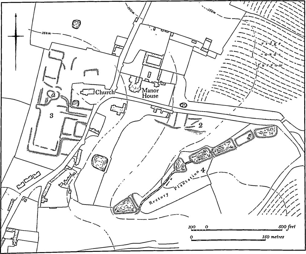
Fig. 111 Thorpe Mandeville (2) Settlement remains, (3) Site of manor house and gardens, (4) Fishponds
The earthworks fall into three parts. In the centre ('a' on plan) is a disturbed area of ground and an amorphous mound 1.3 m. high which is undoubtedly the site of the manor house itself. To the S. is a large rectangular area bounded by scarps up to 1 m. high which is presumably a garden court, laid out in front of the house. To the E. of it are traces of three sunken rectangular areas 1 m. deep which were presumably other parts of the garden. Other scarps to the N. of the manor house site are less well defined and may be the remains of paddocks or yards at the rear of the house. (RAF VAP CPE/UK/1994, 1025–7; air photographs in NMR)
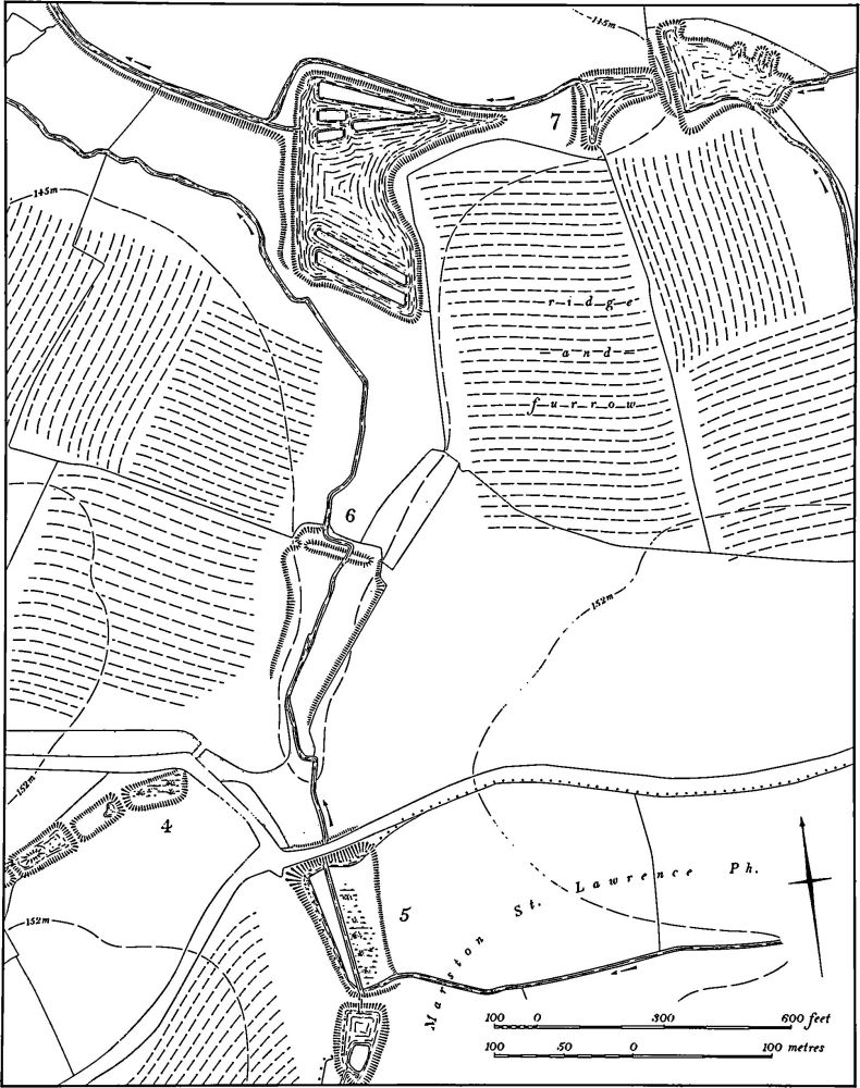
Fig. 112 Thorpe Mandeville (4, 5) Fishponds, (6) Dam, (7) Ponds
b(4) Fishponds (SP 532447–535448; Figs. 111 and 112), lie S.E. of the village in the bottom of a small valley draining N.E., on Upper Lias Clay between 160 m. and 148 m. above OD. There are six ponds, though perhaps only four or five of them are medieval in origin. The two lower ponds appear to be medieval and largely unaltered. They are rectangular depressions, 1.5 m. deep, cut down into the valley bottom. The adjacent one to the S.W. is larger, with a low rectangular island within it, and has probably been altered in the 18th century. The pond to the S.W. again has certainly been changed in outline and has a more irregular form, again with a low long island within it. The fifth pond, of roughly triangular shape, appears to be entirely of post-medieval design. The south-westernmost pond, some distance upstream, is 1.5 m. deep and bounded by a massive dam 2 m. high on its N.E. side. Again, if it is medieval in origin it has been altered at a later date. All six ponds are shown on a map of 1806 (NRO) and the field to the N. was then called Fisher's Close. On a later map of 1851 (NRO) the ponds are termed 'fishponds'. (RAF VAP CPE/UK/1994, 1025–7; air photographs in NMR)
b(5) Fishponds (SP 537446; Fig. 112), lie S.E. of the village and immediately S. of the Banbury to Northampton road, on Upper Lias Clay at 146 m. above OD, in the valley of a small N.-flowing stream. Both have been altered in post-medieval times but are probably medieval in origin. The lower pond is rectangular, 1.75 m. deep, with a massive dam on the N., now over 3 m. high, but presumably heightened to carry the modern road which crosses it. In 1806 (NRO, Estate Map) it was depicted with two long parallel islands within it. The upper pond is more irregular with at its S. end a small island also marked on the 1806 map. (RAF VAP CPE/UK/1994, 1025–7)
a(6) Dam (SP 537458; Fig. 112), known locally as Giants Grave, lies E. of the village in the bottom of the valley of a N.-flowing stream, on Upper Lias Clay at 145 m. above OD. It is 2 m. high with a gap in the centre through which the stream now passes, another gap at its E. end where a modern track has cut through, and a shallow gap at its W. end which is the original overflow channel. It formerly ponded back a large area of water the limits of which are marked by a low scarp on the valley sides behind it. It is not marked on an Estate Map of 1806 (NRO) and was presumably already disused. The site is probably a medieval fishpond. (RAF VAP CPE/UK/1994, 1025–7)
a(7) Ponds (SP 538453; Fig. 112), lie in the valley of a small W.-flowing stream, near its former junction with a N.-flowing tributary, on Upper Lias Clay at 145 m. above OD. The ponds appear to be of post-medieval date, probably of the 18th century, and were perhaps used for breeding wildfowl and for boating. The largest, lowest pond is roughly trapezoidal with a triangular extension E. up the valley and groups of low marshy islands at each end. The central pond is the smallest and is roughly triangular and the third one has an irregular N. side with four 'bays' cut into it. The water from all three ponds passes not into the original stream but into a high-level leat which runs N.W. towards Lower Thorpe where there was once a watermill. All the ponds are depicted exactly as they are now on a map of 1806 (NRO). (RAF VAP CPE/UK/1994, 1025–7)
b(8) Ponds (SP 531442), in the E. part of Whitnell's Spinney, in the S.E. of the parish, on Upper Lias Clay at 168 m. above OD. Two small rectangular depressions in a shallow valley are the remains of ponds which existed in 1806 (NRO, Estate Map).
a(9) Windmill Mound (SP 53704546), in the N. of the parish to the N.W. of a group of ponds (7), on Upper Lias Clay at 145 m. above OD. The mound is 20 m. in diam. and 0.7 m. high with slight traces of a ditch. It is surrounded by ridge-and-furrow, but as it has been ploughed over in recent times (local inf.) it is no longer possible to be certain whether the ridges pass under or around the mound. The field in which it stands was known as Windmill Ground in 1806 (NRO, Estate Map). It has been interpreted elsewhere as a round barrow, but is more likely to be a windmill mound. (RAF VAP CPE/UK/1994, 1026–7)
(10) Cultivation Remains. The date of the enclosure of the common fields of Thorpe Mandeville is not known, but was certainly before 1806 (NRO, Estate Map). Ridge-and-furrow of these fields exists on the ground or can be traced on air photographs over much of the parish though it occurs only rarely on the extensive Northampton Sand deposits where modern cultivation has largely destroyed it. It is arranged in end-on and interlocked furlongs, mainly of reversed-S form and is particularly well preserved to the E. of the village where a field with ridges 8 m. –9 m. wide and up to 0.75 m. high was known as Banky Grindle in 1806 (SP 536451). The term 'Banky' for areas covered by high ridge-and-furrow is common in this part of the county. (RAF VAP CPE/UK/1926, 1210–4; CPE/UK/ 1994, 1024–8, 1100–3)