An Inventory of the Historical Monuments in the County of Northamptonshire, Volume 4, Archaeological Sites in South-West Northamptonshire. Originally published by Her Majesty's Stationery Office, London, 1982.
This free content was digitised by double rekeying. All rights reserved.
'Weston and Weedon', in An Inventory of the Historical Monuments in the County of Northamptonshire, Volume 4, Archaeological Sites in South-West Northamptonshire(London, 1982), British History Online https://www.british-history.ac.uk/rchme/northants/vol4/pp163-167 [accessed 30 April 2025].
'Weston and Weedon', in An Inventory of the Historical Monuments in the County of Northamptonshire, Volume 4, Archaeological Sites in South-West Northamptonshire(London, 1982), British History Online, accessed April 30, 2025, https://www.british-history.ac.uk/rchme/northants/vol4/pp163-167.
"Weston and Weedon". An Inventory of the Historical Monuments in the County of Northamptonshire, Volume 4, Archaeological Sites in South-West Northamptonshire. (London, 1982), British History Online. Web. 30 April 2025. https://www.british-history.ac.uk/rchme/northants/vol4/pp163-167.
In this section
64 WESTON AND WEEDON

Fig. 119 Helmdon, Wappenham and Weston and Weedon Medieval settlements and estates
(OS 1:10000 a SP 54 NE, b SP 64 NW, c SP 65 SW)
The modern parish is roughly triangular, covering some 1300 hectares, and contains the villages of Weedon Lois and Weston, as well as the hamlets of Milthorpe, Oakley Bank and Plumpton. The latter two settlements once lay in a separate parish of Plumpton (Fig. 119). The Banbury Lane forms the N. W. parish boundary and a small stream, one of the headwaters of the R. Tove, flows E. along the S. boundary. Another stream which joins the former flows S.E. along much of the N.E. boundary and the villages of Weston and Weedon Lois lie in the valley of a third, central stream. The ridges between the streams, and the high ground in the N.W. with a maximum height of 170 m. above OD, are covered by Boulder Clay but the down-cutting of the streams has exposed Oolite Limestone and Upper Lias Clay. There are some small patches of glacial sands and gravels.
Prehistoric and Roman
A gold stater of Cunobelinus (Mack 206–7) was found at Weedon Lois before 1864 (BM; J. Evans, Coins of the Ancient Britons (1864), 298; S. S. Frere (ed.), Problems of the Iron Age in S. Britain (1958), 234). Many Roman coins are also recorded from Weedon Lois (T. Reynolds, Iter. Britannia (1799), 470). A Greek bronze coin of Sala, found at Weston in the early 19th century (G. Baker, Hist. of Northants., II (1836–41), 115), is thought to be a modern loss (VCH Northants., I (1902), 222).
a(1) Iron Age and Roman Settlement (?) (SP 586478), close to the N.W. parish boundary, on Boulder Clay at 165 m. above OD. A small scatter of sherds said to be of Iron Age and Roman types has been noted, but there is some doubt concerning the identification of this pottery (BNFAS, 3 (1969), 2; OS Record Cards).
a(2) Roman Settlement (?) (SP 578465), in the W. of the parish, on Upper Lias Clay at 137 m. above OD. A scatter of Roman pottery has been found (Northants. Archaeol., 10 (1975), 163).
b(3) Roman Settlement (?) (SP 602475), N. of Weedon Lois village, on Boulder Clay at 150 m. above OD. Some Roman sherds have been discovered (OS Record Cards).
b(4) Roman Settlement (SP 605454), in the S.E. of the parish, on Upper Lias Clay at 122 m. above OD. Roman pottery is recorded (Northants. Archaeol., 10 (1975), 163).
Medieval and Later
b(5) Motte or Ringwork (SP 602470; Figs. 13 and 120), stands in the centre of Weedon Lois village, immediately E. of the church and on the W. side of The Green, on Boulder Clay at 145 m. above OD.
Nothing is known of the history of this site, but in 1086 Weedon was held by Ghilo who also held the adjoining parishes of Sulgrave and Culworth (VCH Northants., I (1902), 344–5). The earthworks at Weedon may have resembled ringworks at Culworth (1) and Sulgrave (3) and the three sites may have been contemporary and constructed by the same man. Excavations at Sulgrave have indicated that the ringwork there was constructed in the late 11th century.
The remains are tree-covered and in poor condition; as a result it is almost impossible to recover their original form. They now consist of a roughly rectangular raised area, some 2 m. high, with a flat top, but with traces of a low bank along its N. side. There is no indication of a ditch and the road to the W. and the footpath to the S. both appear to have been cut back into the original mound. The gardens of the house to the S. of the site are also raised to much the same height as the castle mound, and this has led to the suggestion that there may have been a bailey here (OS Record Cards), but this idea can only be confirmed by excavation.
The relationship of the ringwork to the green and to the existing street plan is interesting. It is possible that both the ringwork and the gardens to the S. might be encroachments on an older and larger green. Alternatively the green could have evolved from the abandoned castle site in the later medieval period. In the S.W. corner of the mound are traces of stonework said to be the abutments of a feature called the Japanese Bridge and perhaps the relic of an 18th or 19th-century garden feature (OS Record Cards).
b(6) Settlement Remains (SP 602469; Figs. 13 and 120), formerly part of Weedon Lois, lie on the S. side of the present through road, on Boulder Clay at 144 m. above OD. The remains are very fragmentary, but consist of low scarps and banks which bound one large and one small enclosure, with a more disturbed area which includes fragments of stone foundations at the W. end. The larger enclosure has been ploughed over with ridge-and-furrow. No date or function can be assigned to these remains. (RAF VAP CPE/UK/1994, 1092–3, 3092–3)
b(7) Fishponds (SP 607467; Figs. 13 and 120), lie S. of Weedon church, in the valley of a small S.E.-flowing stream, on Upper Lias Clay between 132 m. and 137 m. above OD. Three rectangular ponds cut down into the valley bottom are edged by scarps up to 1.5 m. high and each has a dam 0.5 m.–1.5 m. high at its S.E. end. The upper dam is much degraded and the others have modern cuts through them. The stream now flows in a channel almost 2 m. deep, cut into the rising ground on the S.W. side of the valley.
Nothing is known of the history of these ponds, although they are traditionally said to have belonged to the small priory at Weedon which was established in the early 12th century as a cell of the Benedictine Abbey of St. Lucien, Oise, France. The priory was always small and poor. In 1392 it was sold to the Cistercian Abbey of Biddlesden, Buckinghamshire, but in 1440 its land passed to All Souls College, Oxford. The site of the priory is unknown, though it perhaps lay in the vicinity of the present church. (VCH Northants., II (1906), 183–5; RAF VAP CPE/ UK/1994, 1092–3, 3092–3)

Fig. 120 Weston and Weedon (5) Motte or ringwork, (6) Settlement remains, (7) Ponds at Weedon Lois
a(8) Settlement Remains (SP 587469; Figs. 13 and 121), formerly part of Weston, lie at the W. end of the village, on Boulder Clay at 145 m. above OD. Weston today consists of a main street running N.W.-S.E. with a side road extending S.W. from near the centre and there are indications that the main street once forked at each end. A small green still exists at the S.E. The earliest map of Weston, of 1593 (All Souls College, Oxford; copy in NRO; M. W. Beresford, The Lost Villages of England (1954), Plate 3), only shows part of the village but indicates that some of the houses at the N.W. end of the main street then stood on an 'island' surrounded by lanes. This suggests that there may once have been a second green at this end of the village. The village may therefore have had a layout much neater than now, and other features confirm this idea. On the N. side of the main street the existing closes form a regular pattern which, though now disrupted by the gardens of Weston Hall to the E., are shown as continuous on the 1593 map.
On the S. side of the street, in an area not covered by the 1593 map, the pattern of closes is much less regular. To the S.E. there are small hedged paddocks. To the S.W. there is now a single large field but low banks and scarps within it indicate that a pattern similar to that in the S.E. once existed here. Ridge-and-furrow occupies some of the paddocks. The most obvious feature in this part of the village is a large rectangular pond up to 1.5 m. deep ('a' on plan). The level area bounded by scarps to the S.E. of the pond is the site of a recent tennis court (local inf.). On the N. edge of the site ('b' on plan) are the remains of at least two house-sites, indicating that the village street was once built up along this section. (RAF VAP CPE/UK/1994, 1093–5, 3093–4; air photographs in NMR; CUAP, PN73)
a(9) Mound (SP 58704851), lies in the N. of the parish, immediately N.W. of the old Plumpton-Weston parish boundary and within the former parish of Plumpton, on Boulder Clay at 168 m. above OD. The mound is only 0.25 m. high and 12 m. in diam., much spread, and crossed by a modern hedge. It may be the site of a windmill. (BNFAS., 3 (1969), 3)
a(10) Settlement Remains (SP 597483; Figs. 119 and 122; Plate 2), formerly part of Plumpton, lie around the church and houses on a low ridge between two N.E.-flowing streams, on glacial gravel, Boulder Clay and Jurassic Clay between 137 m. and 152 m. above OD. The village was until recently the centre of an independent parish.
Plumpton is first mentioned in Domesday Book as a single manor of one hide with a recorded population of eight (VCH Northants., I (1902), 341). In the 1301 Lay Subsidy it is probably included within the entry for 'Weedon and hamlets' and it is certainly included with Weedon in the 1334 Subsidy. In 1377 60 people at Plumpton over the age of 14 paid the Poll Tax (PRO, E179/155/28) and in 1525 10 people paid the Lay Subsidy (PRO, E179/155/ 159). The 1673 Hearth Tax Return lists 12 people at Plumpton (PRO, E179/254/14). By 1801 only 56 people lived in the parish and though the population had risen slightly by 1831 it was down to 52 in 1871. By 1883 (1st ed. OS 25 in. plans, Northants. LV6 and 7) only the church, manor house, rectory and six cottages remained at Plumpton. Since then two of the cottages have been demolished.

Fig. 121 Weston and Weedon (8) Settlement remains at Weston
The earthworks of the village survived undamaged until the 1960s when the whole of the S.E. part was ploughed and returned to grass. The earthworks are still visible but in poor condition. Subsequently the area W. of the church was ploughed and the fishpond to the N.W. was partly filled in. The accompanying plan (Fig. 122) is partly based on OS plans and air photographs taken before destruction in conjunction with the Commission's survey. The site is of interest for a number of reasons. The earthworks indicated that the village had extended N.E. at some time, a process that perhaps involved an element of planning. The oldest part of the village may have been the S.W. section, centred on the church and what was probably a moated manor house and associated fishponds (see below).
To the S.E. of the church and what is now the Old Rectory, on the E. side of the main through road, are areas of disturbed ground ('a' on plan) clearly representing former house-sites with long narrow closes extending down the hillside behind them. To the N.E. are further housesites and closes ('b' on plan), but these are more regular with the ditched and embanked boundaries exactly straight. On the N.W. side of the road, the present manor house and its garden has destroyed any house-sites that existed ('c' on plan) but the fragmentary remains of evenly spaced closes suggest that the whole N.E. part of the village was a planned addition to the older S.W. part.
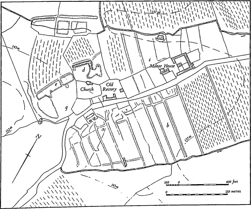
Fig. 122 Weston and Weedon (10) Settlement remains at Plumpton
Immediately N. of the church is a ditch, U-shaped in plan with a broad external bank ('d' on plan). The E. side of the ditch opens out into an area of shallow quarrying. It is possible, though not certain, that this is the N.W. side of a small moat, perhaps the site of the medieval manor house, and other earthworks which lay to the S.W. and N.W. may have been part of the manorial complex. The feature to the S.W. was shown on the OS plan of 1883 as a broad trench described as Old Gravel Pits ('e' on plan). However, on air photographs taken before destruction it is clear that this trench consisted of two conjoined rectangular ponds with a broad bank or dam on the N.W. side. These were set on a spring line just below the crest of the hill. A curved length of hollow-way, also now destroyed, lay to the S.W. of the ponds. Further N.W., in the valley bottom, the OS plan shows two roughly rectangular depressions with a ditch on the N.W., also called Old Gravel Pits ('f' on plan). Though these have been partly destroyed, enough remains on the ground to show that these too were fishponds, with an overflow channel bypassing them on the N.W. side.
No finds have been made in the area, except for a patch of limestone rubble in the modern arable land to the S. of the church ('g' on plan). This is associated with a few 13th to 14th-century sherds and considerable quantities of post-medieval pottery, glass and tile. (RAF VAP CPE/UK/ 1994, 3093–4; CUAP, NU84–5, SA42–4)
(11) Cultivation Remains. The common fields of Weston and Weedon were enclosed by an Act of Parliament of 1771. No details are known of the earlier field arrangements, but a map of 1593 (All Souls College, Oxford, copy in NRO) depicts the strips and furlongs which then covered most of the parish. The recoverable pattern of ridge-and-furrow fits the strips and furlongs shown on the map exactly and indicates that the strips themselves were made up of varying numbers of ridges. The map also shows that there were extensive areas of old enclosures, especially in the S.E. corner of the parish (SP 580463) and implies that the land to the N.W. of Weston village was also enclosed at that time. However normal common-field ridge-and-furrow exists in both places.
Ridge-and-furrow of these fields exists on the ground or can be traced on air photographs over most of the old parish of Weston and Weedon and except for a small area S. of Milthorpe the pattern is virtually complete. It is all arranged in end-on or interlocked furlongs; in some places there are continuous blocks of end-on furlongs running down the gentle slopes (SP 598463–603455). Large areas still survive in permanent pasture, especially N.E. of Weedon on either side of the road to Plumpton.
A road marked on the 1593 map as 'The Way from Helmdon' is still traceable as a broad open track running N.W. from near the S.E. boundary towards Moreton Pinkney (SP 583462–579473).
The date of the enclosure of the common fields of Plumpton is not known. Ridge-and-furrow of these fields is visible on the ground or on air photographs over most of the land of Plumpton, arranged in end-on and interlocked furlongs. It is notable that there is no traceable ridge-and-furrow within the area of Plumpton Wood (SP 604495). This suggests that this area was never ploughed in medieval times. (M. W. Beresford, The Lost Villages of England (1954), Plates 2 and 3; RAF VAP CPE/UK/1926, 1050– 6, 1219–23; CPE/UK/1994, 2089–91)
Undated
a(12) Burials (SP 597467), found in 1948 immediately W. of the hamlet of Milthorpe, when the area was being cleared for housing development, on gravel at 152 m. above OD. No finds were made apart from human bones, but the burials were probably Saxon or medieval. (OS Record Cards)