An Inventory of the Historical Monuments in the County of Northamptonshire, Volume 4, Archaeological Sites in South-West Northamptonshire. Originally published by Her Majesty's Stationery Office, London, 1982.
This free content was digitised by double rekeying. All rights reserved.
'Farthinghoe', in An Inventory of the Historical Monuments in the County of Northamptonshire, Volume 4, Archaeological Sites in South-West Northamptonshire(London, 1982), British History Online https://www.british-history.ac.uk/rchme/northants/vol4/pp53-58 [accessed 30 April 2025].
'Farthinghoe', in An Inventory of the Historical Monuments in the County of Northamptonshire, Volume 4, Archaeological Sites in South-West Northamptonshire(London, 1982), British History Online, accessed April 30, 2025, https://www.british-history.ac.uk/rchme/northants/vol4/pp53-58.
"Farthinghoe". An Inventory of the Historical Monuments in the County of Northamptonshire, Volume 4, Archaeological Sites in South-West Northamptonshire. (London, 1982), British History Online. Web. 30 April 2025. https://www.british-history.ac.uk/rchme/northants/vol4/pp53-58.
In this section
24 FARTHINGHOE
(OS 1:10000 a SP 53 NW, b SP 53 NE, c SP 54 SW, d SP 54 SE)
The modern parish, of some 1090 hectares, incorporates the former lands of the deserted village of Steane (18) (Fig. 82). Farthinghoe village is located on a N.-S. ridge of limestone and Northampton Sand at about 152 m. above OD. From this high central ridge the land slopes N.W. and N.E. across Upper and Middle Lias Clay and Marlstone to S.-flowing streams on the N.W. and E. boundaries of the parish.
Prehistoric and Roman
A few worked flints have been found in the N. of the area (SP 53754117) and a single flint arrowhead further E. (SP 54054113; inf. D. J. Barrett). An Iron Age gold stater of Whaddon Chase (Mack 138) type was found in the parish in 1847 (PSA, 2 (1850), 43; S. S. Frere (ed.), Problems of the Iron Age in S. Britain (1958), 186; Ashmolean Museum).
(1–4) Flint-Working Sites. Worked flints of Neolithic and Bronze Age type have been found at four places in the parish during field-walking (inf. D. N. Hall).
c(1) Flint-Working Site (SP 529407), in the N.W. of the parish, on the S. side of a small stream, on clay at 107 m. above OD.
c(2) Flint-Working Site (SP 540407), in the N. of the parish, on clay at 152 m. above OD.
c(3) Flint-Working Site (SP 544402), 600 m. S.S.E. of (2), on Northampton Sand at 150 m. above OD.
a(4) Flint-Working Site (SP 535385), in the S. of the parish, on Oolite Limestone at 155 m. above OD.
a(5) Ditched Trackway, Linear Ditches, Enclosures and Pit Alignment (centred SP 542376; Fig. 54), in the extreme S. of the parish, on the N.W. side of the disused airfield, on Great Oolite Limestone, between 149 m. and 155 m. above OD. Air photographs (NCAU) show numerous features though some have been obscured or destroyed by the buildings and taxi-paths of the airfield. The clearest feature is a ditched trackway running N.W.-S.E. from which extend long linear ditches, perhaps the boundaries of former fields. Further N. there are some ill-defined sinuous ditches and to the S. is a group of small enclosures and a length of pit alignment. Two parallel ditches in the S. may be another ditched trackway.
a(6) Linear Ditches (SP 545395), S.E. of the village, on limestone at 145 m. above OD. Air photographs (NCAU) show very indistinctly a group of linear ditches.
a(7) Enclosure (?) (SP 549391), W. of Steane Park, immediately N. of the A422 road, on Great Oolite Limestone at 132 m. above OD. Air photographs (NCAU) show all but the S.E. side of what appears to be a double-ditched enclosure 30 m. by 20 m., orientated S.W.-N.E. The S.W. side, if it existed, has been destroyed by the road. Two roughly parallel linear features to the N. of the enclosure appear to be modern.
b(8) Enclosure (SP 553384), immediately S. of Steane Park, on Northampton Sand at 138 m. above OD. Air photographs (NCAU) show the W. part of what appears to be a trapezoidal enclosure orientated E.-W. It is 40 m.– 45 m. wide and at least 70 m. long.
a(9) Pit Alignment and Enclosure (centred SP 525386). lie immediately W. of Farthinghoe Lodge, in the S. of the parish, on Northampton Sand and Upper Lias Clay at 154 m. above OD. Air photographs (CUAP, ABY83–5) show a clearly marked pit alignment running N.N.E. for 250 m. from SP 525385. Other cropmarks in the vicinity appear to be the result of frost-fracture but there may be a small rectangular enclosure to the W. of the pit alignment (SP 52503865). A little to the S.E. (SP 526383) other air photographs (NCAU) show several indistinct ditches as well as some possible enclosures. The only clear feature is a ring ditch 20 m. in diam.
a(10) Roman Settlement (SP 528384), lies to the S.E. of an area of cropmarks (9), on Northampton Sand at 152 m. above OD. Much Roman pottery, building stone and a quern have been noted (Northants. Archaeol., 10 (1975), 154).
a(11) Roman Settlement (?) (SP 527398), lies W. of the village, on Marlstone Rock, at 114 m. above OD. Fieldwalking has led to the discovery of Roman material (Northants. Archaeol., 10 (1975), 154).
c(12) Roman Settlement (?) (SP 530401), lies 450 m. N.N.E. of (11), on a small outcrop of Northampton Sand and limestone at about 130 m. above OD. Roman pottery and tile has been found over about 2 hectares (Northants.

Fig. 54 Farthinghoe (5) Ditched trackway, linear ditches, enclosures and pit alignment
Archaeol., 10 (1975), 154).
c(13) Roman Settlement (?) (SP 53464110), in the N. of the parish on the S. side of a S.W.-flowing stream, on Upper Lias Clay at 110 m. above OD. A small quantity of Roman pottery has been found in the sides of a field drain. As the adjacent fields are under pasture the extent of this possible settlement is not known (inf. D.J. Barrett).
a(14) Roman Settlement (?) (SP 537398), immediately N.E. of Farthinghoe Church, on limestone at 155 m. above OD. A small scatter of Roman sherds is recorded (inf. D. J. Barrett).
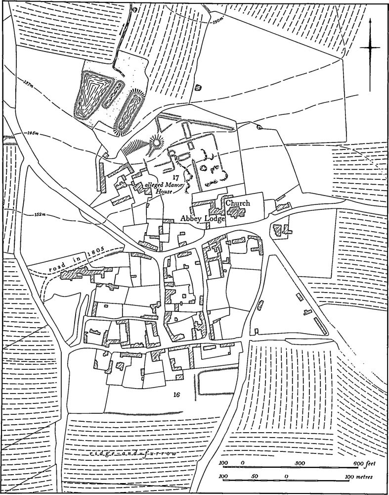
Fig. 55 Farthinghoe (16) Settlement remains, (17) Garden remains
Medieval and Later
a(15) Occupation Site (SP 53903986), lies 300 m. E. of Farthinghoe church, on limestone at 152 m. above OD. Excavations in 1973 revealed a circular stone structure about 2 m. in diam. and at least 1.5 m. deep. It was burned inside and large quantities of bones, mainly pig, were found. It is likely to have been a well-head. Road works in the following year exposed two ditches in the same area. These contained early medieval pottery, possibly of late Saxon date, as well as fragments of bone and charcoal (Northants. Archaeol., 10 (1975), 166).
a(16) Settlement Remains (SP 533397 and 535394; Figs. 55 and 83), formerly part of Farthinghoe, lie on the N.W. and S. sides of the village, on Northampton Sand and Upper Lias Clay at just over 152 m. above OD. The present plan of Farthinghoe, although distorted by the main A422 road which runs through it, consists of a basic grid of three or possibly four short N.-S. lanes bounded by two E.-W. roads and with an open space in the N.E. corner near the church. On a map of 1805 (NRO) the W. end of the northern E.-W. street is shown as extending further W., completing the grid pattern of the village. By 1841 (NRO, Tithe Map) this part of the street had been abandoned and the area in which it lay was called 'Old Road'. Most of the line of this street has been built over or destroyed by the later rectory and its garden but one side of a possible hollow-way is still visible as a low scarp 0.5 m. high, close to its junction with the main street. The building-line of an existing row of houses also shows the former line of the street.
On the S. side of the village, behind the houses lining the S. side of the E.-W. street, there are the slight remains of former closes and a hollow-way. These have been largely destroyed but they are visible on air photographs taken in 1947. (RAF VAP CPE/UK/1926, 5212–3)
a(17) Garden Remains (SP 534399; Fig. 55), lie on the N. side of the village, N.W. of the church on clay between 137 m. and 153 m. above OD. These remains have not been correctly interpreted previously, partly because of the identification of the mount as a windmill mound (OS Record Cards; CBA Group 9, Newsletter 5 (1975), 29) and partly because of damage by quarrying.
The earthworks are certainly the site of a formal garden, perhaps of 17th-century date, and presumably associated with the manor house. The house immediately W. of the church. Abbey Lodge, is usually called the Manor House, although the farmhouse to the N.W. is said locally to be the original one.
The most prominent feature of the site is a large mound, once probably circular but now badly damaged, 2.5 m. high with a flat top 8 m. across and with a ramp on its S.W. side. This mound lies near the N.W. corner of a rectangular area bounded on the N. by a low scarp much altered by a track which runs alongside it, on the E. by a low scarp, and on the S. by the garden of Abbey Lodge. The W. side has been destroyed by quarrying. The interior is also damaged by quarry pits but a low bank and two shallow rectangular former ponds can be identified; a larger pond also now dry lies outside the area to the N. A scarp on the N. side overlies a larger bank which cuts across the N. of the site. Some slight scarps immediately S. of the mound may be the remains of a tennis court (local inf.). Below the mound on a spring line at the bottom of a steep natural slope are three roughly rectangular ponds. These may be medieval in origin, but have been much altered. The whole area was known as The Park in 1805 (Map in NRO) and Park Hovel and Yard on the Tithe Map of 1841 (NRO). The field to the N. was then called Mount Close. (RAF VAP CPE/UK/1926, 5212–3)
b(18) Deserted Village of Steane (SP 551389; Figs. 56 and 83), lies in the S.E. of the parish, on clay and limestone at 137 m. above OD. Steane was once an independent parish with its own land unit and is first recorded in 1086, in Domesday Book, listed as a single manor of two hides with a recorded population of 18 (VCH Northants., I (1902), 344). In 1301 16 people paid the Lay Subsidy (PRO, E179/155/31) and in the 1316 Nomina Villarum Steane is mentioned as an independent vill. The village paid 40s. 4d. for the 1334 Lay Subsidy (PRO, E179/155/3) and in 1348 28 tenants are recorded (PRO, E134/102/9). In 1377 51 people over the age of 14 paid the Poll Tax (PRO, E179/ 155/28) but by 1428 there were less than 10 households in the village (Feudal Aids, 4, 51). In 1620 the present chapel was built adjacent to the manor house, but whether it is on the site of the earlier church is not known. Bridges (Hist of Northants., I (1791), 196), writing in about 1720, said that there was only one house in the parish in addition to the manor house, but that 'it is formerly believed . . . that there was once here a flourishing town'. (K. J. Allison et al., The Deserted Villages of Northants. (1966), 46)
The remains of the village lie W. and S.W. of the manor house within an area known as Knoll Field. The earthworks are very slight and have been damaged by later quarrying but a generally rectangular arrangement of closes is recognisable. The main identifiable features include a hollow-way 1 m. deep which crosses the S.W. part of the site from N.W. to S.E. ('a'-'b' on plan). At its S.E. end it appears to have met another slight hollow-way running at right angles to it but the latter is not clear. Immediately N.E. of the main hollow-way there is a rectangular enclosure ('c' on plan) bounded by the hollow-way on the S.W. and by scarps and ditches on the other side. It is sub-divided by low scarps into about four closes and at least one sunken building platform is visible. The N.W. end of this enclosure is cut by a large quarry from which a few sherds of 13th and 14th-century pottery have come. At the N. end of the site there is another enclosure ('d' on plan) also sub-divided into small closes. (RAF VAP CPE/UK/1926, 2214–5; CUAP SA22–3, AAV 17–18)
b(19) Fishponds and Garden Remains (SP 555391; Fig. 57), lie N. of the manor house on the S. side of a broad shallow valley, on Upper Lias Clay at 122 m. above OD. The site was probably once a set of medieval fishponds but has been remodelled, presumably in the early 17th century as part of a garden associated with the manor house.
Part of a late medieval building still remains, but the house was apparently rebuilt in the early 17th century by Sir Thomas Crewe who also rebuilt the chapel in 1620, perhaps on the site of the original medieval church. The land to the N. may have been turned into a formal garden at the same time.
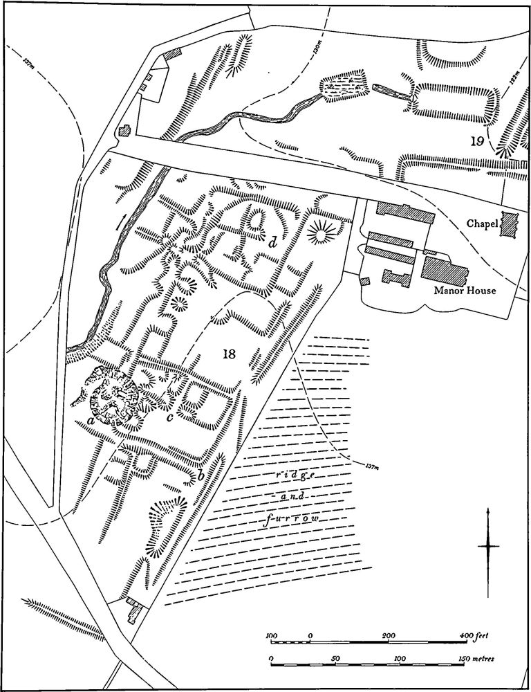
Fig. 56 Farthinghoe (18) Deserted village of Steane
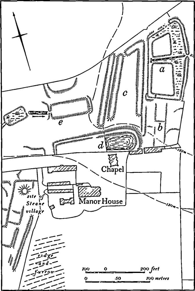
Fig. 57 Farthinghoe (19) Fishponds and garden remains at Steane
The remains can be divided into five parts. The only surviving earthworks of the medieval fishponds, probably much altered, lie in the N.E. ('a' on plan). They consist of two roughly rectangular islands, surrounded by shallow ditches which widen on the E. to form a pond. The islands themselves are flat and featureless. The E. side of the broad pond is edged by a steep-sided flat-topped bank up to 2 m. high with traces of a dry-stone wall on the inner side in the N.E. corner. This bank is very similar to terrace walks in other late 16th or early 17th-century gardens (e.g. RCHM Northants., III (1981), Canons Ashby (2)) and may be an addition of that period. To the S. ('b' on plan) is a roughly rectangular area sloping up gently to the S. with a number of very slight scarps less than 0.25 m. high across it. These form no detectable pattern but may be the remains of flower-beds or paths of a formal garden. To the W. of the medieval ponds are three long narrow ponds up to 2 m. deep bounding a roughly rectangular area now ploughed ('c' on plan). Two of the ponds, on the W., lie parallel and close to each other; the other, which returns S.W. at its N. end, lies to the E. To the S. again ('d' on plan) is a large embanked pond which, at its E. end, is raised 2.5 m. above the adjacent ground. In the N.W. is another rectangular pond ('e' on plan) with a shallower, smaller one to the W. These may not have been part of the formal gardens. (RAF VAP CPE/UK/1926, 2214–5; CUAP SA22)
(20) Cultivation Remains. The common fields of Farthinghoe had been enclosed by the early 18th century, for Bridges (Hist. of Northants., I (1791), 168), writing in about 1720, recorded that the whole lordship was enclosed, but the exact date is not known. Ridge-and-furrow of these fields exists on the ground or can be traced on air photographs over much of the old parish of Farthinghoe. It is arranged in end-on and interlocked furlongs. The most notable feature is N. of the village on a steep W.-facing hill of Upper Lias Clay capped with Northampton Sand (SP 537400–539408); the hillside has collapsed into landslips and mud-flows. Where the landslips are most marked (SP 538407) the land was never cultivated in medieval times and the adjacent ridge-and-furrow terminates at the upper limits of the slip. Further S. the ridge-and-furrow extends down the hillside over the landslips and as a result has an unusually uneven appearance both in plan and elevation.
The date of the enclosure of the common fields of the deserted village of Steane is also unknown, though it was probably in the late 15th or early 16th century. At least 1000 sheep were being grazed on the land by 1547 (K. J. Allison, The Deserted Villages of Northants. (1966), 46). Ridge-and-furrow of these fields exists on the ground or can be traced on air photographs only in a few places as modern cultivation has destroyed much of it. Where it survives it is arranged in end-on furlongs, mainly running at right angles across the slopes. (RAF VAP CPE/UK/1926, 2211–6, 3212–4, 5211–5)