An Inventory of the Historical Monuments in the County of Northamptonshire, Volume 4, Archaeological Sites in South-West Northamptonshire. Originally published by Her Majesty's Stationery Office, London, 1982.
This free content was digitised by double rekeying. All rights reserved.
'Grafton Regis', in An Inventory of the Historical Monuments in the County of Northamptonshire, Volume 4, Archaeological Sites in South-West Northamptonshire(London, 1982), British History Online https://www.british-history.ac.uk/rchme/northants/vol4/pp60-64 [accessed 30 April 2025].
'Grafton Regis', in An Inventory of the Historical Monuments in the County of Northamptonshire, Volume 4, Archaeological Sites in South-West Northamptonshire(London, 1982), British History Online, accessed April 30, 2025, https://www.british-history.ac.uk/rchme/northants/vol4/pp60-64.
"Grafton Regis". An Inventory of the Historical Monuments in the County of Northamptonshire, Volume 4, Archaeological Sites in South-West Northamptonshire. (London, 1982), British History Online. Web. 30 April 2025. https://www.british-history.ac.uk/rchme/northants/vol4/pp60-64.
In this section
26 GRAFTON REGIS
(OS 1:10000 a SP 74 NW, b SP 74 NE)
The parish, which is roughly rectangular, covers about 930 hectares and includes the village and former parish of Alderton. It lies on the S.W. bank of the R. Tove which defines the N. and E. boundaries; an E.-flowing tributary stream marks the S. boundary. The lower areas in the N. and E. alongside the river are covered by alluvial deposits and Upper Lias Clay at about 75 m. above OD; Oolitic Limestones are exposed on the steep sides and summits of several spurs, and the higher ground in the S.W., with a maximum height of 115 m. above OD, is covered by Boulder Clay.
The parish contains several important medieval monuments, including a motte or ringwork (5) and the site of a later manor house and garden (6) at Alderton, a group of monastic buildings at Grafton Regis (4) and extensive settlement remains at both villages (2) and (7).
Prehistoric and Roman
Roman coins, including a gold coin of Antony and Octavia and several silver republican ones, possibly a hoard buried before A.D. 43, were found at Alderton in about 1821 (Wetton, Guide Book to Northampton, (1849), 185; VCH Northants., I (1902), 215; OS Record Cards).
a(1) Ring Ditch (?) (SP 738480), in the extreme N.W. of the parish, close to the R. Tove, on river gravel at 137 m. above OD. Air photographs (NCAU) show an indistinct circular feature which may be a ring ditch.
Medieval and Later
b(2) Settlement Remains and Manor House Site (SP 756467; Fig. 13), formerly part of Grafton Regis, lie in and around the village, on a ridge of Great Oolite Limestone, at just over 90 m. above OD.
Grafton Regis, though a small village, has an unusual plan. At its N.E. end there is a single street with only the manor house and the church on the N.W. side. This street once continued further N.E. but is now blocked by two houses; the only through-road turns sharply N.W. and then N.E. to cross the Tove valley towards Ashton. To the S.W. the single street divides and the two branches run back to meet the present Northampton-Old Stratford road.
The surviving earthworks fall into three groups. On the S.E. side of the single street, opposite the manor house, are the very fragmentary remains of small embanked closes with areas of uneven ground within them, probably the sites of former houses. To the S.W. small paddocks along the N. side of the northern branch road probably once had houses within them. The back boundary of these paddocks is continued N.W. by a massive bank up to 1 m. high, suggesting that further houses and gardens once lay to the S. where the present old school and some cottages now stand. A similar line of houses may have stood along the southern branch road though no identifiable remains can be traced.
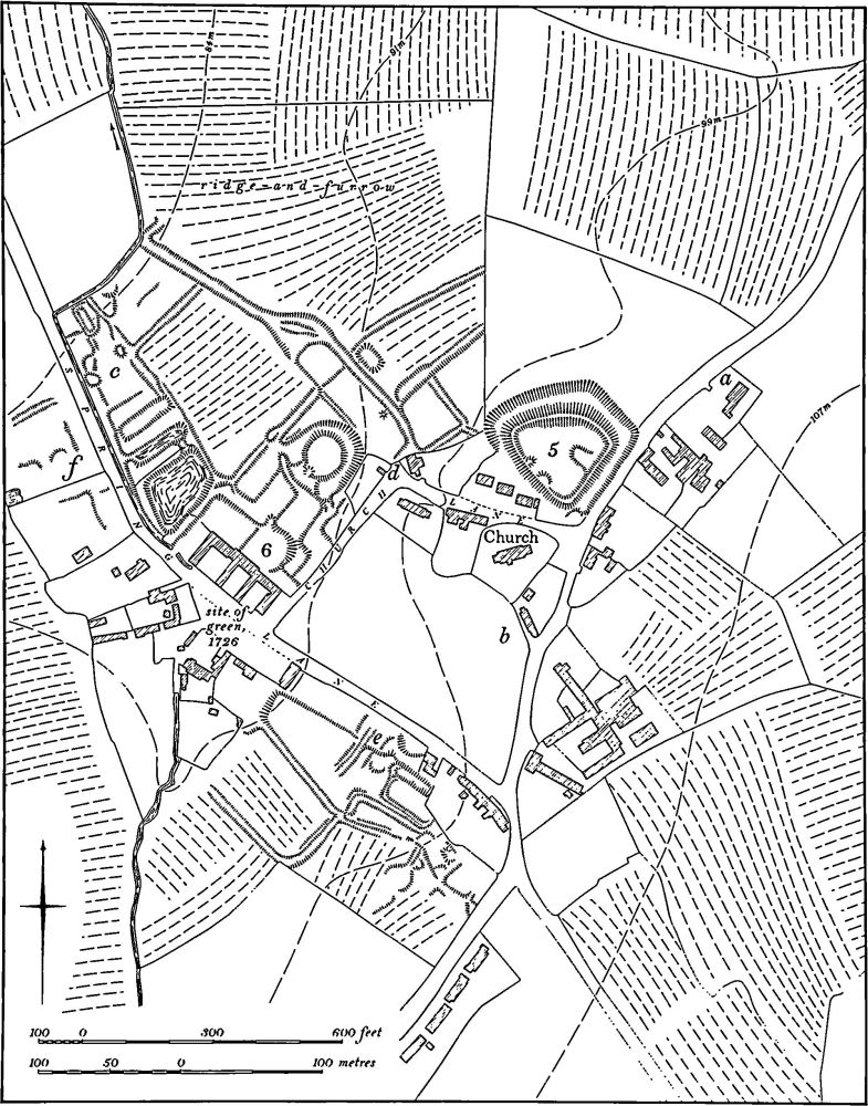
Fig. 59 Grafton Regis (5) Motte or ringwork, (6) Site of manor house and garden remains, (7) Settlement remains at Alderton
Within the triangular area formed by the two branch roads and the main Northampton road there is a more extensive area of earthworks. These are in a poor state of preservation, but several small rectangular embanked closes can be identified, surrounding a much larger enclosure which in turn has an irregular embanked area within it. The earthworks may be the site of one of the medieval manor houses of Grafton Regis and the whole of this S.W. part of the village is perhaps an addition to an earlier single-street settlement near the church. (RAF VAP CPE/UK/ 1926, 3244–5; CUAP AWN55; air photographs in NMR)
b(3) Enclosure (SP 761467), lies 250 m. S.E. of Grafton Regis church, on the S.E. side of a limestone ridge at 90 m. above OD. A small roughly rectangular enclosure 100 m. by 75 m., orientated N.W.-S.E., with a rectangular projection on its S.E. side is bounded by a shallow ditch and low internal bank. It overlies earlier ridge-and-furrow which can still be traced in the interior. A shallow rectangular pond and a number of more indeterminate features lie within the enclosure. No date or function can be assigned to this enclosure. Other earthworks, mainly drainage ditches, and another pond now largely filled in, lie on the lower ground to the N.E. (RAF VAP CPE/UK/1926, 3244–5; CUAP, AWN58; air photographs in NMR)
b(4) Site of Priory and Manor House (SP 752467), lies 300 m. W. of Grafton Regis village, on limestone at about 90 m. above OD. The site was fully excavated in 1964–5. Before excavation there was an area of disturbed earthworks, partly overploughed with ridge-and-furrow which terminated on a headland and ditch a little to the S. of the site. Beyond the headland was a hollow-way running W. from the village through the ridge-and-furrow.
It had been assumed that this was the site of one of the two medieval manor houses of Grafton, probably the one held by the Woodville family in the late medieval period. The excavation revealed a range of 13th to 14th-century buildings, apparently of monastic origin, including what was perhaps a small unaisled church with a cloister and other structures on its N. side. Other, detached buildings, probably of the same date, included a barn or hospital, a kitchen and a dovecote. In the 15th century the site seems to have been converted to domestic use. The cloister was removed and replaced by a new building and in the church a new floor was laid which included tiles incorporating the arms of Woodville and the Yorkist rose. The whole site was abandoned soon after the late 15th century and, presumably, converted to arable land.
The excavator identified the site as the beneficed hermitage or small priory of Grafton known to have been supported by the Woodville family in the late 13th and 14th centuries but which apparently ceased to exist at the end of the 14th century. The lands of this priory passed to St. James' Abbey in Northampton, but it is possible that the Woodvilles took over the buildings and altered them. (Med. Arch., 9 (1965), 203; 10 (1960), 202–4; VCH Northants., II (1906), 137; RAF VAP CPE/UK/1926, 3243–4; air photographs in NMR)
a(5) Motte or Ringwork (SP 740469; Fig. 59; Plate 3), usually known as The Mount, stands on high ground on the N.E. side of Alderton village, on Great Oolite Limestone at 100 m. above OD. Nothing is known of its history apart from some 13th-century references to it (G. Baker, Hist. of Northants., II (1836–41), 120) but it appears to be of 11th or 12th-century date. It consists of a roughly triangular area raised only about 1 m. above the adjacent land, but surrounded by a very large ditch up to 5 m. deep below a well-marked inner rampart or bank which itself is 1 m.–1.5 m. high above the interior. The ditch has been largely destroyed on the S.W. side and modern houses now occupy its line. However even in the early years of this century no ditch was visible here (VCH Northants., II (1906), 403).
Bridges (Hist. of Northants., I (1791), 280), writing in about 1720, said that 'the entrance . . . seems to have been on the western side'. Presumably he was referring to the gap in the inner rampart in the centre of the S.W. side, but this gap does not appear now to be an entrance. The interior is uneven and very overgrown and no features are visible apart from a sloping platform 0.5 m. high on the S.E. side. On a map of 1726 (NRO) the ditch is shown as filled with water and the area is called Castle Mound.
a(6) Site of Manor House and Garden Remains (SP 738470; Fig. 59; Plate 3), lie on the W. side of a valley, on land sloping S.W., on limestone and clay at 88 m. above OD. This may have been the site of the medieval manor house of Alderton, but it is certain that William Gorges built 'a very large mansion-house' here in 1582 (J. Bridges, Hist. of Northants., I (1791), 280) and the surviving earthworks must for the most part be the gardens of this house. The house was partly demolished in the early 18th century and the surviving section was then described as 'embattled' (Bridges, op. cit.). On a map of 1726 (NRO) no house is shown on the site but an elaborate gateway is depicted, flanked by two long buildings presumably barns or stables. Baker refers to mullioned windows in the farm buildings (Hist of Northants., II (1836–41), 120).
Nothing remains of the mansion-house; its site, presumably, is occupied by the 19th-century barns and cart-sheds. To the N.E. of these buildings, on gently sloping ground, is a roughly rectangular area bounded on the S.E. by the existing Church Lane, on the N.W. by a low, broad, flat-topped bank or terraced walk and on the N.E. by an old hollow-way (see (7) below). The S.W. part of the area is divided into rectangular blocks, bounded by low scarps nowhere much above 0.5 m. high except on the S.E. side where some of them rise to 1.5 m. These scarps apparently mark the edges of formal flower-beds or terrace-walks which formed part of a small late 16th-century garden. To the N.E. is a large circular mound surrounded by a broad ditch which was once water-filled. The flat top of the mound is level with the adjacent ground to the N. and E. and up to 1.75 m. high above the ground to the S. and W. The ditch is between 1 m. and 2.25 m. deep below the mound. It has been suggested that this mound might be a motte or a moated site (OS Record Cards) but it is much more likely to be a mount, contemporary with the rest of the garden. Such mounts raised above formal gardens were a normal feature of this period.
To the N.W. of the farm buildings there are three rectangular ponds, one large, the other two small and narrow. These may have originated as medieval fishponds, belong ing to a manor, but the raised flat-topped terraces that bound them on the N.E. and S.W., suggest that they were either incorporated into the later garden or were first constructed in the late 16th century as part of the overall garden design. (RAF VAP CPE/UK/1926, 3241–2; CUAP, ZJ58, AML68, AWN61; air photographs in NMR)
a(7) Settlement Remains (centred SP 740468; Fig. 59; Plate 3), formerly part of Alderton, lie in and around the village, on limestone and clay between 83 m. and 103 m. above OD. Alderton is first mentioned in 1086 in Domesday Book where it is listed as two manors with a total recorded population of eight, both held by the Count of Mortain (VCH Northants., I (1902), 322, 328). In 1301, 38 people at Alderton paid the Lay Subsidy (PRO, E179/155/ 31) but thereafter there is no record of its size until the Lay Subsidy of 1523–4 when 21 people paid tax (PRO, E179/ 155/40). By the early 18th century there were about 25 houses there (J. Bridges, Hist. of Northants., I (1791), 280) and the village remained much the same size until recent development.
The earliest map of the village is dated 1726 (NRO). It shows the village virtually as it is now, except for three buildings which no longer stand. At the N.E. end of the village was a row of cottages ('a' on plan), immediately S. of the church was a farm house ('b' on plan), and at the N.W. end of Spring Lane, N. W. of the ponds in the garden remains (6), was a house and barn ('c' on plan). Immediately S.W. of the manor house site there was a large triangular green. The Enclosure Map of 1819 (NRO) shows a similar situation, except that most of the green had been enclosed under the Act, the house and barn further N.W. had disappeared and so had the row of cottages. The farm lying S. of the church is shown with a large area of outbuildings around it; this farm was completely demolished later in the 19th century.
The evidence of these maps, together with the surviving earthworks, suggests that there were once two distinct parts to the village of Alderton, along two roughly parallel roads running N.W.-S.E. The road to the N.E. was in part the present E. end of Church Lane. A broad hollowway up to 1.5 m. runs from the sharp bend in Church Lane ('d' on plan). Ridge-and-furrow edges this hollowway over most of its length except at its S.E. end where there are at least three small closes. These may once have contained houses, but the area was already devoid of buildings in 1726. On the N.E. side of Spring Lane, the second of the two main streets, S.W. of the church, nothing is visible on the ground or on air photographs taken in 1947 (RAF VAP CPE/UK/1926, 3241–2). However, the area has recently been ploughed and returned to grass and this may have concealed the evidence of earlier occupation here. On the opposite side of the road ('e' on plan) are some disturbed earthworks comprising low banks, scarps and shallow ditches which, though partly quarried into, probably represent an area of former settlement though again any houses had gone by 1726. Similar slight remains lie further N.W. along the S.W. side of Spring Lane ('f' on plan) in an area devoid of buildings in 1726. On the site of the house and barn to the N. ('c' on plan) the well-marked foundation walls of a rectangular stone structure still survive, as well as some other slighter scarps and ditches.
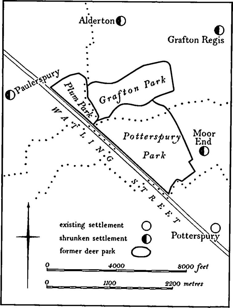
Fig. 60 Grafton Regis (8), Paulerspury (21) and Yardley Gobion (8) Deer parks
a(8) Deer Park (centred SP 740455; Fig. 60), in the S.W. part of the parish, mainly on Boulder Clay, on land sloping S.E. between 114 m. and 99 m. above OD. It lies partly in the old parish of Grafton Regis and partly in the old parish of Alderton. There was a medieval deer park at Grafton though its exact area is unknown and it was probably very small. It was greatly enlarged in 1532 when Henry VIII ordered that 76 acres of land of the fields of Grafton and 70 acres of Alderton should be incorporated into the park. According to Leyland this new park was enclosed partly by pales and partly by a hedge. It was enlarged again in the early 17th century but was finally disparked in 1644 (Northants. P. and P., 5 (1975), 225). The area of the park in its final form is known from a map of 1720 (NRO). At this date it was contiguous with the parks of Yardley Gobion (8) to the S. and Plum Park to the W. (Paulerspury (21)). Nothing remains on the ground of any major boundaries. Most of the park's circuit is marked by normal hedge-banks though part of the S. side follows an old lane, deeply hollowed in places (SP 738453–745454). Much of the interior of the park has ridge-and-furrow and the documented incorporation of part of the fields of Grafton and Alderton within its bounds is proved by the fact that the northern boundary runs obliquely across earlier ridge-and-furrow (SP 742459 and 744461). (RAF VAP CPE/ UK/1926, 3242–3, 5241–3)
(9) Cultivation Remains. The common fields of Grafton Regis were finally enclosed by an Act of Parliament of 1727. However, by that time much of the parish was already enclosed and indeed Bridges writing in about 1720 (Hist. of Northants., I (1791), 298) described it as an 'inclosed lordship famous for its meadow-grounds and pastures'. A map of Grafton of 1720 (NRO) shows that only that part of the parish E. of the Northampton-Old Stratford road, together with a small area of land along the S. boundary, remained as open field at that time. The rest of the parish is shown as divided into old enclosures. The date of these is not known though 76 acres of former open field was incorporated into the deer park (8) when it was enlarged in 1532.
Ridge-and-furrow of these fields exists on the ground or can be traced on air photographs over parts of the parish, though the pattern is very incomplete owing to modern destruction. It is arranged mainly in end-on and interlocked furlongs, many of reversed-S form. Considerable areas are still preserved on the low-lying ground in the E. of the parish alongside the R. Tove. A notable feature, now destroyed, was the ridge-and-furrow overlying parts of the monastic and manorial site (4). This ridge-and-furrow, headlands and a hollow-way, all of which bore no relationship to the earlier occupation that lasted until the late 15th century, is an indication of changing land use in the post-medieval period.
The common fields of Alderton were enclosed by an Act of Parliament of 1819 (NRO, Enclosure Map). At that time the deer park (8) and other old enclosures to the N. occupied the S.W. of the parish, but the rest was divided into three large fields, Plumpton Field to the W. and S.W. of the village, Twyford Field to the N. and Burch Field to the E. On an earlier map of 1726 (NRO) the same area of open fields is depicted and though no field names are given all the furlongs are shown and named.
Very little ridge-and-furrow is visible in the former Alderton parish either on the ground or on air photographs. What can be traced appears to be arranged in end-on and interlocked furlongs of normal form and agrees with the furlongs shown on the 1726 map. One small area of ridge-and-furrow in the N.W. of the parish (SP 738478) was known as Windmill Leys in 1726. The best surviving ridge-and-furrow lies immediately N. of the village, along the edge of an abandoned street or hollow-way (SP 739471; partly on Fig. 59). Ridge-and-furrow can also be traced S. of the village in the area already within old enclosures in 1726 as well as within the deer park (8). At the latter site, the park boundary cuts obliquely across the ridge-and-furrow; this supports the documentary record of the enlargement of the park in 1532. (RAF VAP CPE/UK/1926, 1241– 4, 3241–6, 5243–5)
Undated
(10) Mounds (?) (centred SP 751463), immediately S.W. of the village, on limestone at 98 m. above OD. There are said to have been at least four 'tumuli of oblong shape', but no trace exists on the ground or on air photographs (Wetton, Guide to Northampton, (1849), 184; Archaeologia, 35 (1853), map Pl. 16). This may be an incorrect reference to the monastic and manorial site (4) which, before destruction, consisted of an uneven area of earthworks.