An Inventory of the Historical Monuments in Westmorland. Originally published by His Majesty's Stationery Office, London, 1936.
This free content was digitised by double rekeying. All rights reserved.
'Patterdale', in An Inventory of the Historical Monuments in Westmorland(London, 1936), British History Online https://www.british-history.ac.uk/rchme/westm/pp191-195 [accessed 30 April 2025].
'Patterdale', in An Inventory of the Historical Monuments in Westmorland(London, 1936), British History Online, accessed April 30, 2025, https://www.british-history.ac.uk/rchme/westm/pp191-195.
"Patterdale". An Inventory of the Historical Monuments in Westmorland. (London, 1936), British History Online. Web. 30 April 2025. https://www.british-history.ac.uk/rchme/westm/pp191-195.
In this section
77 PATTERDALE (B.c.)
(O.S. 6 in. (a)XII, N.W., (b)XII, S.W., (c)XII, S.E., (d)XIX, N.E.)
Patterdale is a mountain parish at the S. end of Ullswater. The structure numbered (32) is of unusual form. Otherwise the principal monument is the village settlement (61).
Ecclesiastical
c(1). Parish Church of St. Patrick, formerly a chapel of Barton, stands near the head of Ullswater. It was entirely re-built in 1853 but retains the following ancient:—
Fittings—Bell: In vestry—with alphabetic series of letters in Lombardic capitals, probably early 15th-century, cracked. Book: Bible of 1611, rebound in two volumes. Font: cup-shaped bowl (Plate 43) probably 18th-century with modern upper part, cylindrical stem with four attached shafts, probably 13th-century, octagonal base, stopped out to square, 14th-century. Plate: includes cup probably of 1612 (York), also a pewter flagon, probably mid to late 17th century.
Condition—Rebuilt.
Secular
d(2). Cow Bridge over Goldrill beck, nearly 2 m. S. of the church, is a rubble structure of one span with a segmental arch. It was built probably in the 17th century and has been widened on the N. side.
Condition—Good.
d(3). Bridge (Plate 28), over Pasture beck S.E. of Low Hartsop, is a rubble structure of one span with a segmental arch. The 17th-century bridge was about 4½ ft. wide, but it has been widened on the W. side.
Condition—Good.
c(4). Deepdale Bridge, over Deepdale beck, nearly 1¼ m. S.S.E. of the church, is of the same form and date as the last. It was about 7 ft. wide but has been widened on the N. side.
Condition—Good.
d(5). Bridge, over Deepdale beck, 1,140 yards S.S.W. of (4) is of the same form and probably of the same age as the last. The roadway is 8 ft. wide.
Condition—Good.
b(6). Cockpit on the N. side of Glenridding beck and 1,600 yards N.W. of the church, consists of an irregular oval sinking about 23 yards by 16 yards. According to local tradition it was used as a cockpit.
Condition—Bad.
c(7). Patterdale Hall, 500 yards W. of the church, is of two storeys; the walls are of rubble and the roofs are slate-covered. The middle part of the house is of 17th-century origin, but it has been much altered and there are extensive modern additions. In the S.W. range is a re-set doorway with the initials and date I. and D.M. (Mounsey) 1677 and a shield with a plain cross.
Condition—Good.
c(8). The Rectory, E. of the church, is of two storeys; the walls are of rubble and the roofs are slate-covered. It is of 17th-century origin but has been extensively altered. Inside the building are two cupboards with carved panelling, one bearing the initials and date T.S. 1653.
Condition—Good.
Monuments (9–60)
The following monuments, unless otherwise described, are of the 17th century and of two storeys; the walls are of rubble and the roofs are slate-covered. Some of the buildings have exposed ceiling-beams.
Condition—Good or fairly good, unless noted.
c(9). Deer How, 150 yards S.S.E. of the church, has a barn adjoining it on the N. This is perhaps of the 16th century and is of four bays with rough crutchtrusses (Plate 29). It was destroyed by fire in 1934.
c(10). Barn, 1,070 yards N.N.E. of the church, is of four bays with crow-stepped gables.
c(11). Broadhow or Wordsworth's Cottage, 800 yards E. of the church, has a N. wing which has been reduced in length. The house contains a spice-cupboard with an original panelled door. On one of the ceiling-beams are the initials and date L. and M.R. (Ruken) 1670.
c(12). Rooking, cottage and barn, 170 yards S.E. of (11). The Cottage retains an original two-light window with a solid frame. The Barn, S.E. of the house, is of three bays.
c(13). Crookabeck, house 350 yards S. of (12), contains a two-stage cupboard (Plate 40) of the local type, with carved upper panels and balusters supporting the projecting fascia, which has the initials and date R. and I.L. (Robert Lancaster) 1699; there is also a spicecupboard with the same initials and the date 1694. There are also some muntin and plank partitions and panelled doors.
c(14). Barn, 220 yards S.S.E. of (13), is a singlestorey building, retaining a three-light window with a solid frame.
c(15). Byre at Beckstones, about 1 m. S.E. of the church.
c(16). Barn, 140 yards S.W. of (15), is of one storey and retains an original wooden window of three main lights with subdividing bars.
c(17). Noran Bank, house on the W. side of the road, 1,250 yards S.S.E. of the church, retains some original partitions of the local type.
c(18). Causeway, house, 320 yards S. of (17).
c(19). Greenbank, house, 140 yards S.S.W. of (18), has the date 1677 on the E. wall. Inside the building is a panelled cupboard of the local type.
c(20). Moss Side, house, 230 yards S.S.W. of (19).
c(21). Lanehead, house 50 yards S.S.W. of (20), was built probably late in the 16th and much altered in the following century. Inside the building is a threestage cupboard (Plate 35) of the local type, with carved upper panels, pendants and fascia with the initials and date L. and I.H. (Lancelot and Isabel Harrison) 1660, also a spice-cupboard with the initials and date L.H. 1690 and some panelled doors.
c(22). Bridgend, house 70 yards E. of Deepdale Bridge (4), retains an original window with a solid frame.
c(23). Barns, 180 and 300 yards S.E. of (22). The first is partly of two storeys and the second is of one storey and has a truss of modified crutch-form.
c(24). Barn, 300 yards S. of (4), is partly of two storeys and is of five bays.
d(25). Deepdale Hall, 1¼ m. S. of the church, has been much altered, but retains an original two-light window and a projecting staircase.
d(26). Wallend, house 570 yards S.W. of (25), has an original spiral stone staircase and a muntin and plank partition of the local type.
c(27). Dubhow, two barns, nearly 1½ m. S.E. of the church, are both of four bays.
Low Hartsop
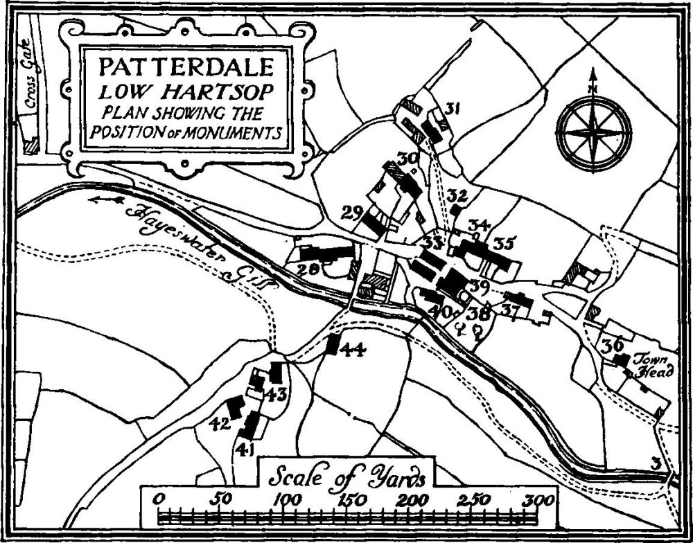
Patterdale, Low Hartsop, Plan Showing the Position of Monuments
d(28). Low House, on the W. side of the village, N. of Pasture beck, has an open spinning-gallery on the N. side and an original window of four lights. The spiral staircase is of stone.
d(29). House, 30 yards N.E. of (28), now a garage and shed, has two original windows.
d(30). Grove Farm, house 30 yards N.E. of (29), was built c. 1700.
d(31). The How, house 35 yards N.E. of (30), retains an original two-light window. The N. walls are built on a marked curve.
Condition—Poor.
d(32). Building, 40 yards S.E. of (31), said to be a drying kiln for grain, was built probably in the 16th or early in the 17th century. It is a square structure, the lower floor entered from the S. and the upper from higher ground on the N. The lower floor contains rectangular floor-space with outward sloping walls forming an oval at the ceiling-level; from each side project piers supporting a central lintel on the long axis of the oval; two further stones are carried across from the responds to the N. wall. A series of stone slabs set edgewise form the supports of the stone floor of the upper chamber. The roof of the upper chamber is of crutch-type.
d(33). Barn, 40 yards S.S.W. of (32).
d(34). House, on the N. side of the road 80 yards E. of (28), has an original chimney-stack with a cylindrical shaft and two added barns at the W. end.
d(35). House, adjoining (34) on the E., has a projecting staircase of spiral form.
d(36). Town Head, house at the E. end of the village 110 yards E.S.E. of (35), has a spiral projecting staircase and contains a cupboard of the local type with the initials and date E. and E.M. 1701.
d(37). Mireside, house 30 yards S.E. of (35), has an open spinning-gallery on the N. side. The external stone stair has an original studded door at the first-floor level; a panelled spice-cupboard is of c. 1700.
d(38). Thorn House (Plate 24), 50 yards W. of (37), has an original open spinning-gallery on the N. side approached by a stone stair; the gallery-front has turned balusters. Inside the building is some refixed original panelling with carved enrichments, and a panelled cupboard. A barn W. of the house is of three bays.
d(39). Barn, immediately N.E. of (38), is of three bays. The first floor has been removed.
d(40). Simpson House, immediately S.W. of (38), has an added W. wing of c. 1700, formerly fitted with a spinning-gallery at the N. end. Inside the building is a spice-cupboard with the initials and date T.A. 1707.
d(41). Green Bank, house and barn at the S. end of the village. The House has a S. part forming a barn and retaining an original three-light window. A Barn, W. of the house is of four bays.
d(42). Cottage, 20 yards N. of (4).
d(43). House, immediately N.E. of (42), was built probably late in the 16th century. It has a chimney-stack with a cylindrical shaft and a stone spiral staircase. The roof is of modified crutch-type.
d(44). Barn, 40 yards N.E. of (43), is of three bays.
d(45). Mill, about 620 yards S.E. of the middle of the village, has a doorway with the date and initials 1706 D. (?) L. The mill-wheel is still in position.
Condition—Ruined.
d(46). Hartsop Hall, about 2½ m. S. of the church, was built probably in the 16th century and has a 17th-century extension on the W. and an 18th-century wing on the S. The N. and S. walls retain original windows with rounded heads to the lights; one window in the S. wall has a moulded label; a doorway in the S. wall, now opening into the wing, has a four-centred head. Inside the building are some original moulded ceiling-beams. The 17th-century staircase has turned balusters and square newels with moulded terminals. Part of the original king-post roof remains.
d(47). Sykeside, cottage over ¼ m. E.S.E. of (46).
d(48). Barn at Caudalebeck, 350 yards S.S.W. of (47), was formerly a cottage.
Condition—Ruinous.
d(49). House and barn at Caudalebeck, 80 yards S.W. of (48). The House contains a spice-cupboard with the initials and date T. and E.A. 1699. The roof is of modified crutch-type. The Barn, N. of the house, is of two dates in the 17th century.
b(50). Thornhow, barn in Grisedale ¾ m. S.W. of the church, is of three bays.
b(51). Braysteads, house 620 yards W. of (50), has an added stable-wing on the N.W.
b(52). Barn, 170 yards S.W. of (51), is of two bays with a crutch-truss.
b(53). Elmhow, house and barns nearly 1½ m. S.W. of the church. The House was extended E. late in the 17th century. It has an original spiral staircase of stone. Inside the building is some original moulded plaster work in the ceiling. The Barn S.W. of the house is of four bays with crutch-trusses. A second barn, W. of the house, is of five bays.
b(54). Grassthwaitehow, house, two tenements, ¼ m. N.N.E. of (50), was extended to the E., c. 1700. A door in the N. wing retains a brass scutcheon and knocker, the former with the initials and date L.A.D. (for Lancelot Dobson and his wife) 1706. The date 1705 appears on the lintel of a barn N.E. of the house.
Settlement at foot of High Hartsop Dod
b(55). Eagle Farm, house at Glenridding nearly ¾ m. N.W. of the church, has an original chimney-stack with an oval shaft.
b(56). House, 270 yards W.N.W. of (55).
b(57). White House, immediately W. of (56), has an original spiral staircase of stone. There is also an original panelled spice-cupboard.
b(58). Tenterhow, house 70 yards N. of (56), retains a panelled spice-cupboard.
b(59). Rattlebeck, house 270 yards W. of (57).
a(60). Glencoyne (Plate 22), on the N. edge of the parish, 1¾ m. N.W. of the church, has an addition of c. 1700 at the back. Two chimney-stacks have cylindrical shafts. Inside the building, a plaster panel in the E. room has the initials and date TH.DH. 1629. There are two spice-cupboards with carved doors and one doorway has a shaped head and a studded door. The staircase has heavy turned balusters.
Unclassified
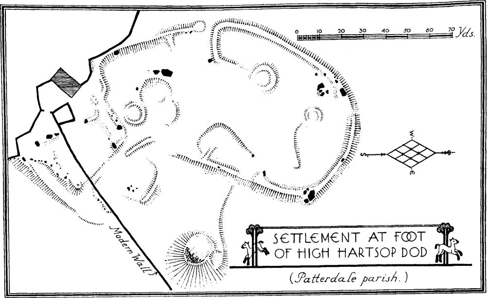
d(61). Village Settlement (560 ft. above O.D.), ½ m. S. of Brothers Water and 300 yards W. of (49), stands on a gentle slope between Hartsop and Kirkstone becks. The surface indications are, for the most part, comparatively slight. The settlement consists of a roughly oval enclosure surrounded by a rampart covering an area of about 1¼ acres. At the S.S.E. are much defaced works covering a further area of about ⅓ acre. It is impossible without excavation to discover the exact significance of the latter, but it is possible that they formed part of the general enclosure and that what looks like the main entrance to the oval enclosure, on the S.E., was only the passage way from one enclosure to the other. On the whole, however, it is more probable that these are outworks. There were two entrances to the main enclosure, one on the W. where the rampart is projected inwards on the N. side of the opening, and the other the one already mentioned on the S.S.E. where the rampart is projected outward on both sides of the opening and though the actual rampart now only projects a few yards there are traces of scarps forming a sunken way up to it. As before mentioned, however, the layout is very difficult to follow at this point, and, such as it is, can best be followed on the accompanying plan. Within the main enclosure are one or two scarps and irregular sinkings and traces of three circular huts; adjoining the most southerly of these are two adjacent roughly circular sinkings which may also indicate sites of huts. On the site, and in several cases incorporated in the rampart, are a number of boulders of considerable size.
About 30 yards E. of the enclosure is a roughly circular mound of about 25–27 yards diameter at its base and connected to the rampart by a slight scarp. On the top of the mound there is an outcropping of small boulders suggesting that this was originally a cairn or alternatively a cairn has been erected on what was in part a natural mound.
Condition—Bad.
d(62). Village Settlement (?), in Deepdale 280 yards S. of (25), on a small flat-topped knoll. The remains are very indistinct but seem to indicate a roughly semi-circular enclosure, about 35 by 21 yards, with faint traces of wall-foundations. There are intermittent traces of a dyke connecting this work with (63).
Condition—Bad.
c(63). Village Settlement (570 yards above O.D.), 300 yards S. of Deepdale Bridge, is of irregular oval form and nearly ¾ acre in extent. There are traces of seven probable huts, of circular form, with an enclosing wall retaining a few orthostats. There are possible entrances on the N.E. and S.W. To the W. are faint traces of what may have been a field-system.
Condition—Bad.
c(64). Village Settlement (?) in Glenamara Park, ½ m. S.S.W. of the church, is perhaps indicated by one or two alignments of stones and some sinkings. There are also traces of possible hut-circles against what was probably part of the rampart.
Condition—Bad.
a(65). Foundations, in Glencoynedale ½ m. W. of (60) and 150 yards S. of the beck, indicate a small tworoomed house with a segmental W. end and a small added chamber on the W. The building is of the same type as that in Crosby Ravensworth (36a) which has been thought by Prof. Collingwood to be of Scandinavian type. The W. room has a small platform in the N.W. angle and a threshold-stone in the W. wall. A curved foundation adjoins the S. wall which may be part of a former enclosure (Plan, p. xlvi).
Condition—Ruined.