An Inventory of the Historical Monuments in Westmorland. Originally published by His Majesty's Stationery Office, London, 1936.
This free content was digitised by double rekeying. All rights reserved.
'Shap, Rural', in An Inventory of the Historical Monuments in Westmorland(London, 1936), British History Online https://www.british-history.ac.uk/rchme/westm/pp206-212 [accessed 30 April 2025].
'Shap, Rural', in An Inventory of the Historical Monuments in Westmorland(London, 1936), British History Online, accessed April 30, 2025, https://www.british-history.ac.uk/rchme/westm/pp206-212.
"Shap, Rural". An Inventory of the Historical Monuments in Westmorland. (London, 1936), British History Online. Web. 30 April 2025. https://www.british-history.ac.uk/rchme/westm/pp206-212.
In this section
86 SHAP, RURAL (D.c.)
(O.S. 6 in. (a)XIII, S.E., (b)XIV, N.W., (c)XIV, S.W., (d)XIV, S.E., (e)XX, N.W., (f)XX, N.E., (g)XXI, N.W., (h)XXI, N.E., (i)XXI, S.W., (j)XXVIII, N.W., (k)XXVIII, S.W.)
Shap Rural is a large parish surrounding Shap Urban. Shap Abbey, the village-settlements and the stone circle (76) are the principal monuments.
Ecclesiastical
e(1). Parish Church of Holy Trinity Mardale (Plate 10), formerly a chapel of Shap, stands ¾ m. above the head of Hawes Water. The walls are of rubble and the roof is slate-covered. The church, consisting of Chancel and Nave without structural division, is probably of mediæval date but the only datable feature is the late mediæval roof. The church was refitted and the West Tower added in 1737. The building was restored in the 19th century.
Architectural Description—The Church (30½ ft. by 16¼ ft.) has a modern E. window. In the N. wall are three 18th-century or later single-light windows. In the S. wall are three windows, similar to those in the N. wall but the second is of two lights. In the W. wall is a modern doorway. At the W. end of the church is a gallery of 1737 and the screen and communionrails are probably of the same date.
Church of Holy Trinity, Mardale, Plan
The Roof is of four bays with late mediæval trusses consisting of tie-beams, king-posts, curved struts and principals.
Condition—Good, will shortly be submerged by the new waterworks.
f(2). Swindale Chapel stands nearly 3½ m. S.W. of the parish church. The walls are of rubble and the roofs are slate-covered. It was built probably as early as the 17th century or perhaps even earlier and to it was added a school-house, at the W. end, said to have been founded in 1703. The chapel was restored in 1874.
Swindale Chapel, Plan
Architectural Description—The Chapel (30½ ft. by 15½ ft.) has a modern E. window. In the N. wall is a round-headed window and a modern doorway. In the S. wall are two windows, the eastern of two round-headed lights partly restored; the western window is of one segmental-headed light. On the W. wall is a bell-cote. The school has no ancient features.
Fittings—Bell: one, uninscribed. Chest: In school —of hutch-type, probably early 17th-century. Glass: In N. window—figure (Plate 42) probably of St. John, foliage background, 15th-century partly restored, said to have come from Clifton church. Screen: incorporates some early 18th-century balusters.
Condition—Good.
c(3). Shap Abbey, ruins on the left bank of the River Lowther, 1 m. W. of Shap church, are of local sandstone rubble and ashlar with dressings of the same material. A convent was founded c. 1191 for Premonstratensian Canons by Thomas son of Gospatrick at Preston Patrick; the establishment was moved to Shap in 1199 and soon after the church was begun at the E. end. The Presbytery was followed in succession by the South Transept, the North Transept, the Crossing and the E. part of the Nave. This was followed by the E. and S. ranges of the cloister. The nave was completed and the W range built probably at a rather later date. The Infirmary was built probably late in the 13th century. Early in the 15th century the presbytery was extended to the E. and a chapel added to the E. of the earlier S. aisle of the presbytery. The West Tower was added early in the 16th century and soon after the walls of the nave were heightened. The abbey was surrendered in 1540–1 and no doubt fell gradually into ruin. The remains were excavated in 1886–8 by Sir William Hope and since then most of the worked stones of the building, except the tower, have been removed to Lowther Castle.
The remains form an interesting example of monastic planning and the tower still stands largely intact. The rest of the building is reduced to its lower walls and parts are much encumbered by fallen material.
Architectural Description—The Presbytery (63½ ft. by 23½ ft.) has two masses of rubble-core standing at the E. angles. There are remains of a moulded plinth on the E. part of the N. wall and a joint and the plinth of a clasping buttress mark the limits of the original presbytery. Near the W. end of this wall is one jamb of a locker. The S. wall retains only footings as do the walls of the S. chapel and aisle. In the presbytery is a large slab, perhaps an altar-slab.
The Crossing (23 ft. square) retains the lower parts of the two N.W. responds; they are probably of the 14th century and are each of semi-octagonal form. The E. piers have been removed and the S.W. pier is covered with fallen masonry. On the N. side is a grave-slab bearing an incised crozier.
The North Transept (25 ft. by 23½ ft.) retains part of the respond of the arcade of two bays which opened into the former chapel-aisle. The E. wall of this aisle retains parts of a chamfered plinth. The archway opening into the N. aisle of the nave has been robbed of all its dressings.
The South Transept (25 ft. by 22½ ft.) retains only the rubble core of the S. respond of the former arcade opening into the chapel-aisle; the pier of this arcade is represented only by the footing. In the S. wall is the broken opening of a doorway into the vestry and there is a similar broken opening in the W. wall; E. of the latter is the foundation of the night stairs to the dorter.
The Nave (84 ft. by 23½ ft.) had formerly a N. arcade of six bays; the lower parts of the columns, existing in 1888, have now been removed, except for the base of the 13th-century E. respond, which had three attached shafts, with moulded bases. The S. wall has the broken openings of two doorways from the cloister and a straight joint between them. Part of the W. wall is incorporated in the tower.
The North Aisle (10½ ft. wide) was ashlar-faced externally and retains the remains of the splays of four windows in the N. wall; below the westernmost window is a length of double-chamfered plinth.
The West Tower (about 18½ ft. square) is of early 16th-century date and of three stages (Plate 150) with a moulded plinth, but ruined at the top and lacking its parapet. The tower-arch is two-centred and of one continuous chamfered order; above it are the marks of the earlier high-pitched roof of the nave and of the later flat-pitched early 16th-century roof. In the W. wall is a gap and above it is a window, formerly of five lights with tracery in a two-centred head; the mullions, sill and most of the tracery are missing; above the window is a niche with side-shafts and trefoiled three-sided canopy, with vaulting, crockets and pinnacles. The second stage has, in the S. wall, a window of two four-centred lights in a square head with a moulded label. The bell-chamber has, in the E. wall, a window of two pointed lights in a square head with a label; there was a similar window in the N. wall but the head and mullion have gone. In the S. wall is a window of one square-headed light with a label. In the W. wall is a window of three pointed lights with remains of vertical tracery in a two centred head with a moulded label.
The Cloister (69 ft. by 61 ft.) had alleys of varying width; the surviving remains of the arcade-walls are shown on the plan.
The East Range contained the vestry, chapter-house and warming-house on the ground floor, with the canons' dorter above. The vestry has no surviving detail. The chapter-house extended beyond the range, the E. wall of which was carried on two arches, both now gone; both divisions had a vaulted roof resting on a central column, but of these no details now survive. The E. part of the N. wall retains its moulded plinth. The doorway from the cloister retains the moulded base of one 13th-century jamb-shaft and there are remains of the bench on the N. side of the outer division of the chapter-house; in the chapter-house is a stone coffin with a shaped head. The warminghouse retains part of the splayed jambs of the doorway from the cloister and in the E. wall is a blocked doorway or window, the base of the fireplace-recess and remains of a doorway near the S. end. Projecting E. from this range are portions of the sub-vault of the rere-dorter including a moulded 13th-century anglecorbel formerly supporting a vaulting-rib.
The South or Frater Range was formerly of two storeys with a sub-vault on the ground floor. This was vaulted in seven bays with a row of six piers down the middle; the bases of these piers have now been removed. At the E. end was a passage with a doorway at either end; parts of the splayed jambs of these doorways survive.
The West Range is now almost covered by fallen material. It includes two rooms with rubble vaults of segmental barrel-form which still survive.
The Infirmary was presumably the detached block immediately S.E. of the E. range. Parts of the E. and N. walls remain; in the former are remains of two doorways and a vault-springer. The hall appears to have stood upon a sub-vault with three free columns down the centre. There are remains of two small wings projecting to the E. To the S. of this block is a range of late 17th-century stabling incorporating remains of a mediæval outbuilding. Still further to the S. are remains of a second mediæval outbuilding perhaps a barn and about 77½ ft. by 19½ ft. On the far side of the river, E. of the claustral block are remains of a walled enclosure with foundations of a rectangular building of uncertain purpose. Immediately to the E. is a low cliff with a wall on the top, perhaps part of the enclosure of the monastery. At the S. end of the modern farmhouse, S.W. of the abbey, is a 17th-century block of stabling incorporating re-used material from the abbey.
Condition—Bad.
Secular
c(4). Rosgill Bridge (Plate 27), over the river Lowther at Rosgill, is a rubble structure of three spans with segmental arches and cut-water piers. The S.W. arch has been largely or wholely reconstructed, but the rest may date from the 17th century.
Condition—Good.
c(5). Parish Crag Bridge (Plate 28), over the Swindale beck 650 yards S. of (4), is a rubble structure of pack-horse type with a segmental arch. The width is 4½ ft. It is probably of 17th-century date.
Condition—Good.
a(6). Naddle Bridge, over the Hawes Water beck on the N.W. boundary of the parish, is a rubble structure with a segmental arch, without parapets. It dates probably from the 17th century and is now disused.
Condition—Fairly good.
e(7). Bridge, over the Hopgill beck 260 yards E. of Mardale church, is a rubble structure with a segmental arch and no parapets. It dates probably from the 17th century.
Condition—Poor.
e(8). Bridge (Plate 26), over the Mardale beck 100 yards W. of (7), is a rubble structure with a segmental arch. It may date from the 17th century but has been partly re-built.
Condition—Good.
c(9). Bridge, over the river Lowther at Keld, was formerly of two spans, but the arches have been replaced by a timber structure. The rubble abutments and the cut-water pier are of the 17th century or earlier.
Condition—Good.
g(10). Bridge, over the river Lowther in Wet Sleddale about 2½ m. S.S.W. of the parish church, is a rubble structure with a segmental arch and a 6 ft. roadway. It dates perhaps from the 17th century.
Condition—Good.
g(11). Bridge (Plate 28), over the river Lowther at Beckside 200 yards S.W. of (10), is of similar date and construction but rather wider.
Condition—Fairly good.
j(12). Crookdale Bridge, over Crookdale beck 6 m. S. of the parish church, is similar in date and construction to the two preceding but the arch is of rougher construction.
Condition—Good.
k(13). High Borrow Bridge, over the Borrowdale beck 1 m. S. of (12), is a rubble structure with a segmental arch. It was built probably in the 17th century but has been considerably widened on the W. side.
Condition—Good.
Monuments (14–71)
The following monuments, unless otherwise described, are of the 17th century and of two storeys; the walls are of rubble and the roofs are slate-covered. Some of the buildings have exposed ceiling-beams.
Condition—Good or fairly good, unless noted.
c(14). Brinns, house on the W. side of the main road nearly 1¼ m. N.N.W. of the parish church.
Rosgill
c(15). Rosgill Head, house at the N.E. end of Rosgill village and 1¾ m. N.W. of the parish church, contains an original spice-cupboard with a panelled door.
c(16). Ash Hill, house 200 yards W. of (15), has a later addition on the E.
c(17). Cottage, on the N.W. side of the road 220 yards W.S.W. of (16), has a doorway with the initials W.B. on the lintel.
c(18). The Lindens, formerly Hutton Gate, house and barn 50 yards W. of (17), have been re-built but incorporate two stones with the initials and dates R.L. 1684 C.S.R. and R.S. 1714.
c(19). Croft House, immediately S. of (18).
c(20). Thorne Farm, house 110 yards S.S.W. of (19).
c(21). Range of cottages on the N.W. side of the road 200 yards N.E. of Rosgill bridge.
c(22). Cottage (Plate 22), immediately opposite (21).
c(23). Green House, 50 yards N.N.E. of Rosgill ridge.
c(24). Rosgill Hall, house and outbuilding 250 yards E.S.E. of the bridge. The House is modern but contains two panels of 16th or 17th-century heraldic glass with variations of the arms of Salkeld. The Outbuilding is probably of late 16th-century date and has a large chimney-projection at the S.W. end. There is also a doorway with a four-centred head and a lintel with the initials and date R. and E.H. 1707.
c(25). House, at Hegdale 650 yards N. of Rosgill bridge, has a stone in the S. gable with the date 1624.
c(26). Cottage, 40 yards N.N.E. of (25).
c(27). Cottage, 140 yards W. of (26).
a(28). Raw Foot, house 750 yards N.W. of Rosgill bridge, has a panelled cupboard of c. 1700. Re-set in a stable is a panel with the initials and date S. and M.B. 1696.
a(29). Toathmain, house 290 yards S. of (28).
a(30). Cottage, 50 yards S.E. of (29), has some original moulded ceiling-joists.
c(31). Goodcroft, house nearly ¼ m. S. of Rosgill bridge, retains one original window.
c(32). House, 570 yards S.E. of (31).
Condition—Ruinous.
c(33). Rayside, house 250 yards S.W. of (32), retains an original window and a fixed dresser with splat-legs.
c(34). Tailbert Foot, house about 2 m. S.W. of the parish church, has an original cupboard of the local type and a fixed dresser of the same date.
c(35). House, now outbuilding 280 yards E. of (34).
a(36). Tailbert Head, house ¼ m. W. of (34).
Swindale
f(37). Swindale Foot, house 1,150 yards N.E. of Swindale Chapel, retains an original three-stage cupboard of rather unusual type. There is also an early 18th-century fireplace with a corbelled head.
f(38). Mullender, house and barn 275 yards N.E. of the chapel.
f(39). Truss Gap, house ¼ m. S.W. of (38).
f(40). Swindale Head, house 1,150 yards S.W. of the chapel, contains a panelled cupboard of the local type and a spice-cupboard with a panelled door.
f(41). House, now outbuilding 40 yards S. of (40). Condition—Poor.
f(42). House, 300 yards S. of (40), retains some original windows.
Condition—Poor.
f(43). High Swindale Head, house nearly 1 m. S.W. of the chapel, retains some original wood window-frames.
Condition—Ruinous.
a(44). Naddle House and outbuilding 3½ m. W. of the parish church. The House was built probably late in the 16th century, extended to the N. early in the 17th century and has a late 17th-century addition on the W. There are remains of original windows. Inside the building the main fireplace retains its original plastered timber hood or flue. The extension has a partition of moulded muntins. The staircase has flat 17th-century balusters. The Outbuildings, S. of the house, has an open gallery along the N. side.
a(45). Wood Nook, house now outbuilding ¼ m. N.E. of (44).
Condition—Poor.
Mardale
e(46). Chapel Hill, outbuildings 40 yards S. of Mardale church, were formerly cottages and stand W. and S. of the modern house. The most easterly has a spinning-gallery at the N. end.
Condition—One building partly ruined.
e(47). Field Head, house now outbuilding ¼ m. W.S.W. of Mardale church, has an original roof with four trusses of crutch-type.
e(48). Bowderthwaite, house now outbuilding 230 yards W. of (47), retains an original stone window.
e(49). Brackenlowe, house 600 yards S.S.W. of Mardale church, has early 18th-century additions.
e(50). Dun Bull Inn, 350 yards S.E. of Mardale church, is modern except for one wing.
e(51). Grove Brae, house 200 yards N.N.E. of (50), has a spice-cupboard with the initials and date W. and H.E. 1682.
e(52). Goosemire, house and outbuilding 150 yards N. of (51). The House has a later extension on the S. The Barn, S.E. of the house, is of three bays.
k(53). Outbuilding near High Borrow bridge about 7 m. S. of the parish church, retains one original window.
i(54). Wasdale Head, house about 4¾ m. S. of the parish church.
Wet Sleddale
g(55). Sleddale Hall, about 3 m. S.W. of the parish church.
g(56). Sleddale Grange, house 650 yards N.E. of (55), retains some original windows and a doorway with the initials and date R. and M.N. 1691 on the lintel (Plate 30) and a moulded label with large stops.
g(57). New Ing, house 640 yards S. of (56).
g(58). Beckside, house 500 yards E.N.E. of (57).
g(59). Howe, house 280 yards N.E. of (58), has a later extension on the N. Some original windows remain and inside the building is an early 18th-century fireplace with a corbelled head.
Condition—Poor.
g(60). Bowfield, house ½ m. N.E. of (55), retains some original windows and there is a fireplace similar to that in (59).
g(61). Stack House, now outbuilding ¼ m. N. of (60).
Condition—Poor.
g(62). Dale End, house ¼ m. E. of (61).
Condition—Ruined.
g(63). Thorney Bank, house 480 yards E.S.E. of (62), retains some original windows and a doorway with embattled enrichment of the lintel and the initials and date H. and I.L. 1690.
g(64). House, later outbuilding, 120 yards N.W. of (63).
Condition—Ruined.
g(65). Cooper's Green, house 120 yards S.W. of (63).
g(66). Steps Hall, cottage on the W. bank of the Lowther over 1 m. S.S.W. of the parish church.
h(67). The Nab, house over 1¼ m. S.E. of the parish church.
Hardendale
d(68). Yew Tree Cottage, 1¼ m. E.S.E. of the parish church, has a doorway with the initials and date A.A. 1692.
d(69). Hall Farm, house 120 yards E. of (68), contains an original cupboard with enriched panels and the initials T. and E.R.
d(70). Nelson Farm, house 100 yards N.W. of (69), contains a cupboard of the local type with the initials and date R. and E.W. 1711.
d(71). Nook Farm, house 140 yards N.N.W. of (70), has an original spice-cupboard with a panelled door.
i(72). Buck Park in Wet Sleddale about ½ m. S.S.W. of (55) consists of an irregular enclosure of about 3 acres. It is surrounded by a rubble wall rising in places to a height of 12 ft. and with remains of coping-stones. Much of the wall has fallen and the entrance cannot now be identified. There is a cross-wall towards the W. end of the enclosure (C. and W. Trans. N.S. XXXIV, p. 43).
Unclassified
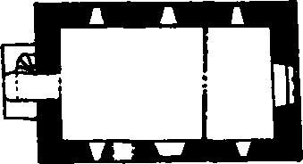
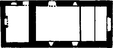
a(73). Village Settlement (about 750 ft. above O.D.), 600 yards E. of Hawes Water and 400 yards S.W. of Naddle Bridge, consists of an irregular enclosure of nearly ½ acre with an enclosing wall varying in width from 6–7 ft. Within the enclosure are traces of cross-walls, but such faint traces as remain of huts indicate that they were rather oval or rectangular in shape and built against the outer rampart; in one case a hut has been built against the outside of the rampart and partly in the thickness thereof. The external wall is in good condition and in the S.W. corner stands to a height, in one part, of 4½ ft. Cross orthostats or orthostatic boulders mark entrances on the N.W. and N.E. sides, while on the S. side the rampart projects at one place forming what may have been a 'dog-legged' entrance.
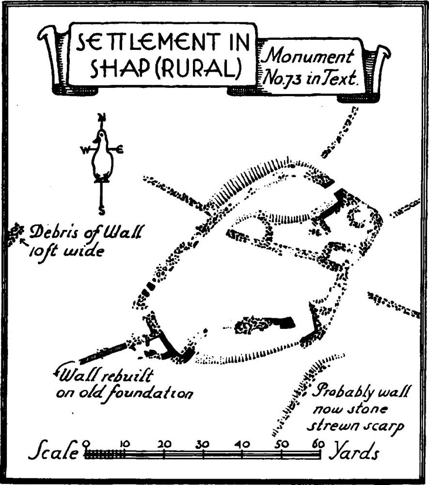
Settlement in Shap (Rural)
Radiating in all directions from the enclosure are foundations of walls probably representing a fieldsystem, though they have now to some extent become involved in later walls. One of these wall-foundations about 34 yards N.W. of the enclosure was apparently nearly 10 ft. thick.
Condition—Good, in parts.
i(74). Village Settlement (800 ft. above O.D.), on the W. side of the junction of the Wasdale and Blea becks 3¾ m. S.S.E. of the parish church, consists of a series of wall-foundations of a field-system and remains of a settlement in a small wood to the N. of the road. There are definite traces of several small rectangular enclosures and one rectangular structure S. of the road. No traces can now be seen of circular huts but the site is much encumbered by trees and boulders. About 100 yards to the S.W. of the wood is a slight mound with a ring of stones about 7 ft. in diameter.
Condition—Bad.
f(75). Village Settlement (about 950 ft. above O.D.) occupies a slight shelf 200 yards S.E. of Hawes Water and 600 yards N.E. of Guerness Nib, seems to have been originally of roughly oval plan. The construction of a new road-way across the site with its accompanying debris has obliterated much of the work. That half of the enclosure to the N. of the modern road shows an encircling wall of fallen stones with one or two possible orthostats and with a probable entrance on the N.W. Within are three circular huts, two of about 12 ft. and the third of about 18ft. in diameter. To the S.E. of the modern road are traces of an outer wall and suggestions of what may have been a hut towards the S.W. About 10 yards S.W. of the northern part of the enclosure abutting on the stream running down to the lake are perhaps traces of a circular hut of about 20 ft. diameter.
Condition—Bad.
c(76). Foundations in a field N.N.W. of the Thunder Stone and nearly 1 m. N.W. of the parish church, provide indications of walls and other structure possibly of no great age.
b(77). Stone Circle on Gunnerkeld Bottom 1¼ m. N.N.E. of the parish church, occupies the top of a slight ridge. The work consists of a slight mound on which is an inner circle of stones 52 ft. in diameter. There is a sinking in the middle probably made by excavation when a cist was found (C. and W. Trans. O.S. IV (1880), p. 539). One stone of the inner circle is standing; it rises about 3 ft. above the ground. An outer circle of stones is about 105 ft. in diameter and three of the stones are still standing; one of these rises nearly 6 ft. above the ground and the fallen stones vary in length up to 9 ft.
Condition—Poor.
e(78). Stone Circle on Wilson Scar 2 m. N.N.W. of the parish church, is about 54 ft. in diameter and stands on a slight mound. Some 32 stones survive but only two or three are still standing. The highest rises only 1¾ ft. above the ground.
Condition—Bad.
g(79). Cairns, near White Raise in Ralfland Forest about 1¼ m. S.W. of Shap Abbey are four in number. (a) On the summit of White Raise is about 36 ft. in diameter and 4 ft. high. It was examined by Canon Simpson (Arch. Journ. XVIII, p. 33) who found calcined bones and fragments of an urn. (b) 50 yards W.N.W. of (a) is about 35 ft. in diameter and 3½ ft. high. It is largely turf-covered. (c) 50 yards S.W. of (b) is possibly only a natural outcrop. (d) About 300 yards N. of (a) is about 15 ft. in diameter and 1 ft. high.
f(80). Cairns on and near Selside Pike, are two in number. (a) On the summit of Selside Pike, is about 25 ft. in diameter. (b) On Selside End about 1,050 yards N.E. of (a) has been much damaged.
c(81). Lynchets, N.E. of Hegdale and N.W. of Rosgill, cover an area of 25–28 acres. The longest undivided strips are about 300 yards and the shortest 150 yards; they vary in width from 15 to 51 ft. and in drop from 3 to 5 ft.
g(82). Lynchets, in Wet Sleddale on a S.E. slope N.E. of (55), extend to about 300 yards.