An Inventory of the Historical Monuments in Westmorland. Originally published by His Majesty's Stationery Office, London, 1936.
This free content was digitised by double rekeying. All rights reserved.
'Crosby Ravensworth', in An Inventory of the Historical Monuments in Westmorland(London, 1936), British History Online https://www.british-history.ac.uk/rchme/westm/pp78-90 [accessed 30 April 2025].
'Crosby Ravensworth', in An Inventory of the Historical Monuments in Westmorland(London, 1936), British History Online, accessed April 30, 2025, https://www.british-history.ac.uk/rchme/westm/pp78-90.
"Crosby Ravensworth". An Inventory of the Historical Monuments in Westmorland. (London, 1936), British History Online. Web. 30 April 2025. https://www.british-history.ac.uk/rchme/westm/pp78-90.
In this section
23 CROSBY RAVENSWORTH
(with Crosby Ravensworth Fell) (E.c.)
(O.S. 6 in. (a)XIV, N.E., (b)XIV, S.E., (c)XXI, N.E., (d)XXI, S.E., (e)XXII, N.W., (f)XXII, S.W.)
Crosby Ravensworth is a large parish with a village 5 m. S.W. of Appleby. The church, Maulds Meaburn Hall, Crake Trees and the village settlements at Ewe Close and elsewhere are the principal monuments. The pre- and proto-historic monuments in the parish are unusually numerous and important.
Ecclesiastical
b(1). Parish Church of St. Lawrence (Plate 94) stands in the village. The walls are of local sandstone rubble with dressings of the same material; the roofs are slate-covered. The piers and arches of the Crossing indicate that there was a late 12th or early 13th-century cruciform church of some size and importance; it had a N. aisle as indicated by the E. respond of the N. arcade and the arch in the W. wall of the transept. The S. arcade was built and the South Aisle added c. 1230–40, and very shortly after the N. arcade was re-built. The North Chapel appears to have been added in the second half of the 14th century, and the West Tower was built probably late in the 15th century. Early in the 16th century the arch opening into the N. chapel was re-built to accommodate a monument. The church is said to have been re-built in 1811, but the work can only have been partial and probably included much of the tower; an extensive and drastic restoration was begun c. 1860, the Transepts being re-built in 1871–2 and the Chancel and Aisles about the same time.
Crosby Ravensworth, Parish Church of St. Lawrence
The details of the crossing, arcades and S. doorway are of considerable interest, and among the fittings the font and a coffin-lid are noteworthy.
Architectural Description—The Chancel (39 ft. by 18 ft.) has no ancient features except the early 16th-century arch in the N. wall; this has moulded responds and flat segmental arch with moulded labels; the S. label has stops carved with a man's head and a modern shield; the N. label has three shields, two of Threlkeld and the third of Threlkeld impaling Bromfleet quartering Vescy.
The North Chapel (20 ft. by 10½ ft.) has a mid 14th-century E. window of two cinque-foiled ogee lights with a quatrefoil in a two-centred head with a moulded label. In the N. wall is a similar window and a 14th-century doorway with moulded jambs, two-centred head and label.
The Crossing (18 ft. by 16½ ft.) has a modern E. arch. The other three arches are of late 12th or early 13th-century date, two-centred and of three chamfered orders; the responds have each two round and one keeled attached shafts with plain capitals, partly restored, and square chamfered abaci, common to the whole respond. The arcade above the W. arch is modern.
The Nave (47½ ft. by 18¼ ft.) has 13th-century N. and S. arcades of three bays with two-centred arches of two chamfered orders with chamfered labels; the quatre-foiled piers have filleted shafts with moulded bases and capitals; the capitals on the S. have nailhead ornament; the N.W. respond and the two on the S. have each a round shaft with a moulded capital and base; the bases of the W. responds are modern, the S.W. respond has a moulded band in addition; the late 12th or early 13th-century N.E. respond is lower than, but generally similar to, the responds of the crossing. The clearstorey is modern.
The North Aisle (11½ ft. wide) is modern except for the partly restored late 12th or early 13th-century arch opening into the transept; it is two-centred and of three chamfered orders; the responds are similar to the N.E. respond of the nave.
The South Aisle (8 ft. wide) is modern except for the E. arch and the S. doorway. The partly restored 13th-century E. arch is two-centred and of two chamfered orders; the responds have each a round shaft with moulded base and capital. The 13th-century S. doorway (Plate 12) has a two-centred arch of three moulded orders with a moulded label and carved stops; the inner and middle orders have dog-tooth ornament and the inner order is repeated on the jambs, without the dog-tooth, the other orders rest on free shafts with moulded bases and capitals.
The West Tower (about 12 ft. square) is of three stages, ashlar-faced and with a splayed plinth. The two lower stages are probably of late 15th-century date and the top stage is modern. The two-centred tower-arch is of one continuous chamfered order; above it are the marks of a low-pitched roof and a cambered ceiling much below the present roof. The W. window is of three plain lights with vertical tracery in a two-centred head. The second stage has a looplight in the S. wall.
Fittings—Churchyard Cross: S. of transept, square base and chamfered square tapering shaft, mediæval. Coffin Lids: In churchyard—N. of N. chapel, (1) narrow tapering slab with ornamental cross on stepped base and shears at side; (2) broken tapering slab with moulded edges; (3) slab with ornamental cross and shield of Threlkeld with a label; (4 and 5) tapering slabs with chamfered edges; (3) early 14th-century, rest probably 13th-century. Font: octagonal bowl with rounded underside and the date 1662, plain stem and rounded base. Monument and Floor-slabs. Monument: In N. chapel—altar-tomb (Plate 94) with roll-moulded angles, fluted and reeded sides, chamfered base and heavy marble slab, three blank shields on each of the long sides, ascribed to Sir Lancelot Threlkeld, 1512. Floor-slabs: In N. chapel—(1) to M.L. 1683 and I.L. 1689. In churchyard—N. of vestry, (2) fragment with the name Hood; S. of porch, (3) with small incised cross, (4) with incised chalice.
Condition—Good, largely re-built.
Secular
b(2). Homestead Moat, at Crosby Ravensworth Hall, immediately W. of the church, forms a polygonal island. The E. arm and part of the S.E. arm have been filled in. There are traces of an outer bank on the N.W. and S.W. and of an inner bank near the N. angle.
b(3). Park Pale or enclosure, 300 yards W.N.W. of the church, is of polygonal form and about 20 acres in extent. It is surrounded by a bank about 12 ft. wide and 2 ft. high, with traces of an inner ditch.
Condition—Bad.
b(4). Village Site at Maulds Meaburn, about 1 m. N. of the church, is indicated by a series of banks and foundation-mounds mainly behind the line of existing houses on the W. of Lyvennet Beck. The remains are too fragmentary for a definite plan to be laid down. On the opposite side of the beck are traces of further foundations and banks. The site is probably mediæval.
Condition—Bad.
b(5). Monk's Bridge, over Lyvennet Beck, 100 yards N.E. of the church, is a rubble structure of two spans with a roadway 7¾ ft. wide. The arches are segmental and the central pier has cutwaters both up and down stream. The bridge was built probably in the 17th century.
Condition—Good.
b(6). Maulds Meaburn Hall, nearly 1½ m. N. of the church, is partly of two and partly of three storeys; the walls are of rubble and the roofs are slate-covered. The property belonged to the Vernon family in the later middle ages and passed from them to Sir John Lowther in 1602. It ceased to be a residence of that family c. 1750. The main block of the house seems to have been re-built late in the 16th century, but may incorporate earlier walls. The S. wing was dated 1610 and appears to have been altered in 1676 when the staircase-wing was added. The buildings at the N. end of the main block were added late in the 17th and during the 18th century. The S. part of the main block was pulled down after 1750 and re-built, of one storey only, in the 19th century.
The great staircase is a good example of its period.
The E. front of the main block is now partly of two storeys and partly of one modern storey. The old part towards the N. has traces of a former porch; the original square-headed doorway now forms a window and the modern doorway, S. of it, has a re-set 17th-century lintel above it with a shield-of-arms of Lowther. The upper storey has two 16th-century transomed and mullioned windows with moulded labels; the gabled dormer above has a three-light window. The N. and S. wings retain some 17th-century windows, more or less altered, and in the E. wall of the S. wing is a doorway with two arched sinkings on the lintel (Plate 30) and a panel with the date 1610 subsequently altered to 1676. The S. side of this wing has a series of early 17th-century mullioned and transomed windows with moulded labels. On the W. side of the house, the staircase retains some late 17th-century mullioned windows, but the original windows in the surviving part of the main block have been altered. The kitchen-wing is probably of the 18th century. Inside the main block, the ground floor has two original fireplaces, the larger with a segmental arch and the southern with a triangular arch in a square head; there is also a doorway with a head of similar form. In the N.E. angle is a spiral staircase entered by a doorway with a three-centred head. The main staircase is approached by a doorway, formerly a two-light window; the late 17th-century staircase (Plate 95) has heavy turned balusters, square newels with ball-terminals and applied husk-ornament, moulded grip-handrails and strings.
The forecourt, E. of the house, has, in the E. wall, a late 17th-century gateway with rusticated piers and ball-terminals; the lowest course has a double-spiral enrichment. To the S. of the house is the former bowling-green with 18th-century summer-houses at the two S. angles. The farm-buildings, N. of the house, have been mostly re-built, but one of them retains a segmental arch and a panel with the initials and date R.L. 1693. The S.E. building was probably a late 17th-century cottage or lodge and retains some original features.
Condition—Good.
b(7). Crake Trees, house, about 1,000 yards N.W. of the church, is of two storeys; the walls are of rubble and the roofs that survive are slate-covered. It is said to have belonged to the family of Lancaster and seems to have been built late in the 14th or early in the 15th century. It was of the local mediæval type, with a single-storeyed hall-block and wings at the N. and S. ends; the S. wing was of the semifortified type and probably carried up as a tower. The main block was remodelled at various times and an upper storey added; the house has long been abandoned and is now roofless and ruined, except the S. wing which has been much reduced in height and is covered with a modern roof. The E. front has 16th or 17th-century windows on both floors, some of the upper ones lacking their mullions; the porch is an addition of the same age and within it is a doorway with a triangular arch in a square head. N. of the porch is a 15th or early 16th-century window with an ogee finialed head cut on the lintel and a rampant leopard carved on the tympanum. The W. side and N. end retain some 16th or 17th-century windows. The S. wing has a re-set 14th-century window-head of one trefoiled ogee light in the S. wall; in the W. wall is a square-headed window; adjoining the wing on this side is a projection enclosing a spiral staircase. The ground floor of the S. wing has an elliptical barrel-vault and a cross-wall. It is entered from the hall-block by a late 14th or early 15th-century doorway with chamfered jambs and shouldered head. The main block and the N. wing retain some 16th and 17th-century fireplaces, one having a triangular arch in a square head. At the N.W. angle of the N. wing is a spiral staircase.
Condition—Ruined.
b(8). Reagill Grange (Plate 21), over 1½ m. N.N.W. of the church, is of two storeys; the walls are of rubble and the roofs are slate-covered. It appears to have belonged to the families of Wharton and Daws. The main block was built late in the 16th century and the N. wing was added in 1700. The house retains many of its original windows with moulded labels, but some of them have lost their mullions. On the S. front is a two-storeyed porch with an original doorway having a triangular arch in a square head and fitted with a nail-studded door. At the back is a gabled projection enclosing a newel staircase. The windows of the N. wing have been mostly altered; there is a re-set door-head with the initials and date T. and E.D. 1700, and a window with a re-set pointed head. The chimneystacks of the main block have cylindrical shafts. Inside the building are some original stone doorways and above a fireplace on the first floor is a panel with the modern date 1652.
There is said to have been a chapel about 70 yards N.E. of the house, but the site is overgrown and there are now no visible traces of walls or foundations.
Condition—Good.
Monuments (9–24)
The following monuments, unless otherwise described, are of the 17th century and of two storeys; the walls are of rubble and the roofs are slate-covered. Some of the buildings have exposed ceiling-beams.
Condition—Good or fairly good.
a(9). Reagill School, 600 yards N.W. of (8), is of one storey. It is said to have been founded by the Rev. Randal Sanderson and has been lengthened towards the S. The E. doorway has the initials and date R.S. 1684 and a Greek inscription. In the N. wall is a re-set 15th-century window from the church. It is of three trefoiled lights in a round head with a moulded label.
a(10). Barnskew, house, over 1 m. N. of (6), has 18th-century additions on the N. and S. The former doorway, now a window, has an embattled enrichment on the lintel, the initials and date H.H. (or M.) H. 1676 and a moulded label. Inside the building is a fireplace with an embattled sinking on the lintel. In an outbuilding is a doorway with a re-set triangular arch in a square head.
b(11). School House, cottage on the W. side of the green, 550 yards S. of (6), retains some original stone windows.
b(12). Meaburn Hill Farm, house, 510 yards S. of (11) and ¾ m. N.N.W. of the church, has an early 18th-century extension on the N. The older part retains some original windows and the extension has a doorway with the initials and date I.A.S. 1708. Inside the building is an original panelled heck or screen and an early 18th-century fireplace with a corbelled head.
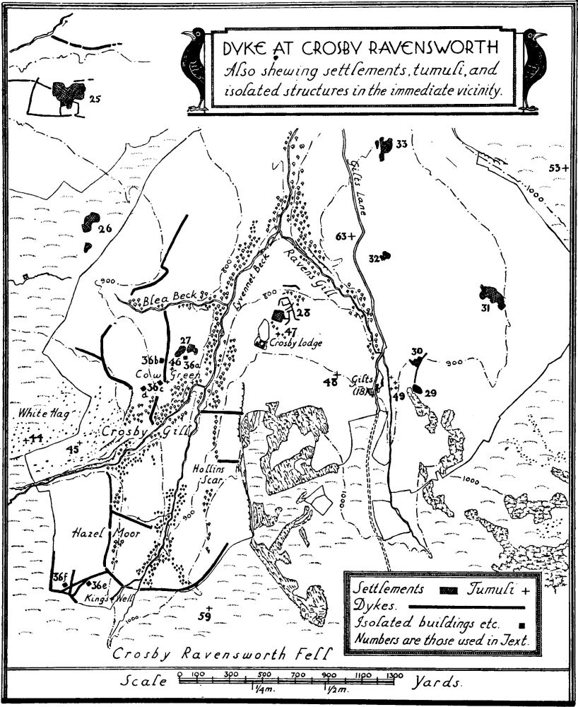
Dyke at Crosby Ravensworth
b(13). Hill Top Farm, house, 200 yards S. of (12), has some original windows with a continuous dripcourse above both ranges.
b(14). High Dalebanks, house, over 1 m. S.W. of the church, is modern but incorporates a lintel with the initials and date I.L. 1693.
c(15). Lane Head, house, 700 yards S.W. of (14), appears to have been re-built in the 18th century but retains two older cupboards; the larger is of three stages recessed at the top and having a carved fascia with the date 1669, supported on two balusters; the small cupboard has the initials and date R. and I.G. 1695 on the door.
c(16). House and outbuilding at the E. end of Oddendale and nearly 2 m. W.S.W. of the church. The House retains two original windows. The Outbuilding, N.E. of the house, has a doorway with a triangular arch in a square head and the initials and date I.A. 1677.
c(17). Outbuilding, 60 yards W. of (16), retains an original doorway.
c(18). Gilts, house and outbuilding, nearly 2 m. S. of the church. The House has 18th-century additions on the N. and N.E. The W. front retains some original windows, now blocked, and there is a continuous drip-course above both ranges. The re-set doorway has the initials and date I.E.W. 1680. Inside the building is a little original panelling and a doorway with an ogee-shaped head of wood. The Outbuilding, S.W. of the house, has a doorway with an ogee head and the initials and date I.W. 1675.
c(19). Crosby Lodge, house, 770 yards W.N.W. of (18), has been much altered. Re-set in the stables is a lintel with the initials and date C.R. 1701.
c(20). Hause Farm, house, about 3¼ m. S.W. of the church, has a projection with a spiral staircase on the W. side. The main E. doorway has moulded jambs and square head (Plate 30) with the initials and date E. and A.P. 1685 in an enriched panel on the lintel; flanking the lintel are shaped stone brackets, and above it is a moulded string-course. The W. doorway has a double-arched enrichment on the lintel. Inside the building is a doorway with an ogee head of wood; there is also a fireplace with curvilinear enrichment on the lintel. In the middle room is a two-stage cupboard with a carved fascia and the initials and date E. and A.P. 1687; the bottom-rail has the date 1618 and may be re-used material.
d(21). Beck Head, house, 900 yards S. of (20), has 18th-century extensions on the S. and S.E. The doorway has a triangular arch in a square head and an enriched lintel with the initials and date R. and E.A. 1682 T. and E.A. On the W. side is a spiral staircase in a three-sided projection.
d(22). Salterwath, house, on the E. side of Birk Beck, 4¼ m. S.W. of the church, contains a small cupboard with the date 1696. Another cupboard has been removed to Shap Wells Hotel.
d(23). Gibsonhill, house, 1,080 yards S. of (22), has been much altered or re-built in the 18th century. It contains the front of a two-stage cupboard with the initials and date W.W., E.W. 1600 R.W., W.E.
d(24). House at Scout Green nearly 5 m. S.S.W. of the church, contains a two-stage cupboard with enriched upper panels, fascia and pendants.
Unclassified
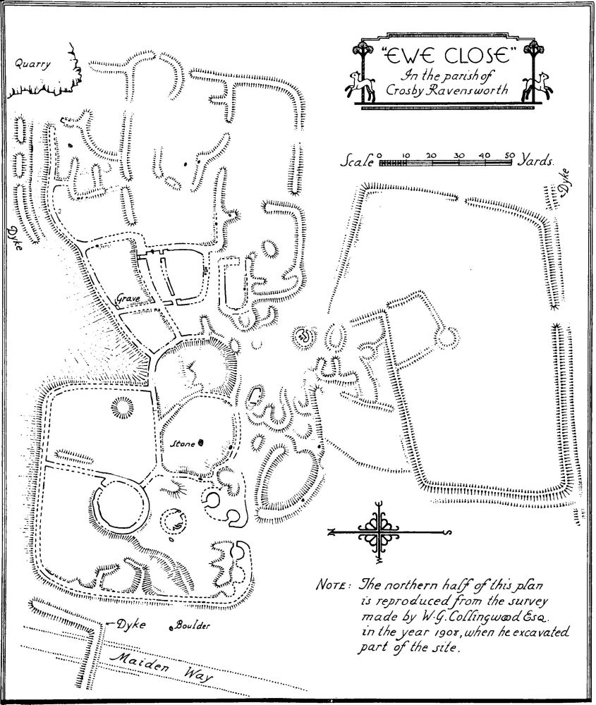
c(25). Ewe Close, village settlement (850 ft. above O.D.), S.W. of Dalebank Beck and over 1 m. S.W. of the church, consists of an almost square walled village with roughly rounded angles and 1¼ acres in extent. To the E. and attached to it are irregular stone-walled enclosures of the usual type covering an area of nearly 2 acres. Immediately adjoining and to the S.E. of the entrance to the main village is a group of huts and one or two irregular enclosures. The walls are everywhere about 6 ft. thick and of orthostatic construction. The middle of the village proper is occupied by a great circular stone-paved hut of 50 ft. internal diameter, and close to it is a smaller hut containing a fireplace. Other huts are grouped within the enclosure, flanking the entrance, which is near the middle of the S. side of the village. In the eastern sector are two structures of a later date. One is a rectangular building (in shape and size comparable to what Prof. Collingwood considers to be the form of the early Teutonic house) and immediately N. of it is a structure which may have been a cattle byre with attached yard.
Incorporating the southern extension and around the site are traces of banks some of which are ditched. Some of these may have formed the enclosures of the farm to which the two later structures belonged.
The site was excavated by W.G. Collingwood in 1907–08 (C. and W. Trans., N.S. VIII–IX). Nothing was found to prove an earlier occupation than the Roman period, but the inhabitants appear to have been low in the cultural scale. The siting of the Roman road which takes a devious line apparently to pass Ewe Close would seem to indicate that the village was already in existence when the road was made.
The pottery found includes the rim of a 2nd-century cooking-pot and the rim of a hammer-headed mortarium of late 3rd or early 4th-century date. They are now in the Tullie House Museum, Carlisle.
In the angle (marked Grave) was found a grave built of cobbles and floored with stone, in which was a skeleton together with the base of a red pot and fragments of another pot. (For details of other finds, see C. and W. Trans., N.S. IX, p. 306.)
Condition—Poor.
"Ewe Close" in the parish of Crosby Ravensworth
c(26). Ewe Locks, village settlement (950 ft. above O.D.), nearly 1½ m. S.S.W. of the church, is situated on the nearly level moor and consists of a large northern and a smaller southern group at a distance apart of some 60 yards. The northern group consists of an oval enclosure and a smaller attached square enclosure, the two covering an area of a little over an acre. According to Prof. Collingwood, who made some examination of the site, both have 6 ft. walls with granite orthostats. It has been suggested that the square enclosure may be of later date—similar features exist at Urswick Stone Walls and in the most northerly settlement at Crosby Garrett—but no definite evidence has yet been obtained on this point.
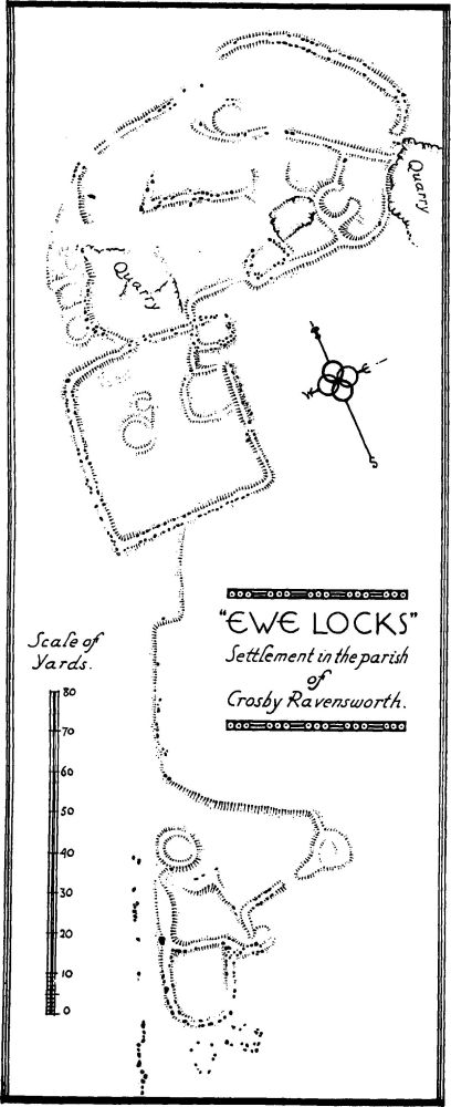
"Ewe Locks" Settlement in the Parish of Crosby Ravensworth.
The southern group consists of at least one circular hut and three small enclosures.
Cow Green Settlement, Crosby Ravensworth Parish.
Two rectangular buildings of later date have been incorporated in the northern group. Each is roughly 20 ft. by 15 ft. internally and has walls with orthostatic boulders. (C. and W. Trans., N.S. XXXIII, 207.)
Condition—Poor.
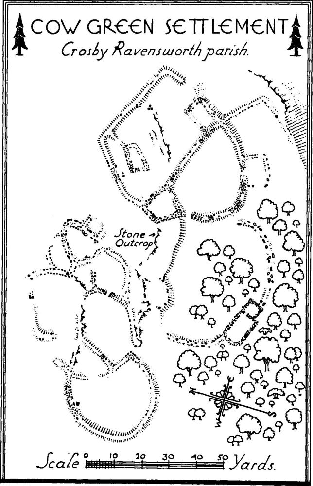
c(27). Cow Green, village settlement (830 ft. above O.D.), about 1¾ m. S.S.W. of the church, stands almost on the W. edge of the ravine of Lyvennet Beck. It consists of two groups of enclosures, the eastern of which is rather better preserved than is the western. In all probability the enclosures were originally joined, the gap between them being caused at a later date to provide access to the stone house (see monument (36a)), which lies to the S. of the settlement. In the W. group there seems to have been one hut and towards the S. end of the S.E. wall of the enclosure is a definite entrance. A doorway also pierces the wall between two of the enclosures towards the N.E. of this group. The E. group consists of roughly rectangular buildings, with adjoining irregularly shaped enclosures. There are still a number of orthostats or orthostatic boulders left, the walls being apparently about 5–5½ ft. thick.
Condition—Poor.
c(28). Burwens, village settlement (850 ft. above O.D.), about 500 yards E.N.E. of (27), consists of a roughly rectangular enclosure nearly 1 acre in area and forming the village itself. Foundations of fielddivisions, adjacent to it on the E. and N., enclose an area of a further 3 or 4 acres. The village-walls are very well marked, indeed more so than on any similar site in the district. There is an entrance at the N.W. end, consisting of a rising passage from which run two roadways. That diverging to the right runs S.E. past a group of hut-circles abutting on the wall and two isolated huts. One of these, about 25 ft. in diameter, is the chief hut of the settlement. Openings between these huts lead to spaces which may be cattle-pens. The other roadway, diverging to the left, runs to the E. and again leads to pens and huts, two of which seem to have either forecourts or ante-chambers.
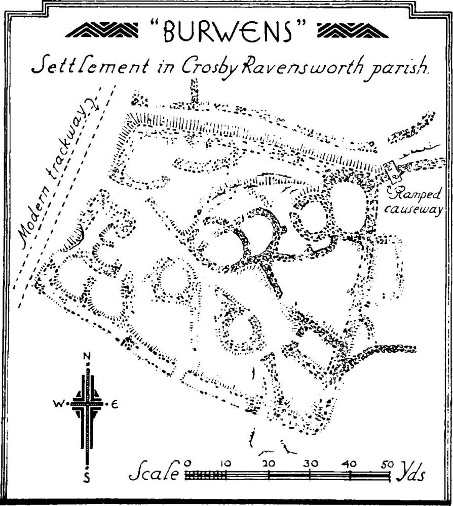
"Burwens", Settlement in Crosby Ravensworth Parish.
Settlement at Crosby Ravensworth
The adjacent field-walls show less distinctly, the walls being slighter in build. A ramped causeway has been formed through the field-wall immediately E. of the enclosure.
Condition—Fairly good.
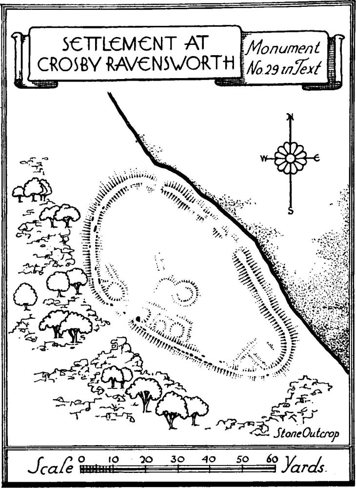
e(29). Village Settlement (920 ft. above O.D.), on the E. side of Ravens Gill and 250 yards E. of Gilts Farm (18), is nearly ½ acre in extent. Very little can now be seen beyond the line of the main enclosing wall. The enclosure is egg-shaped with the apex towards the S. There are signs of a possible entrance on the W. side near the N.W. end. Internally there are very faint traces of walls forming the usual enclosures and faint suggestions of two or three huts against the main enclosing wall.
Condition—Bad.
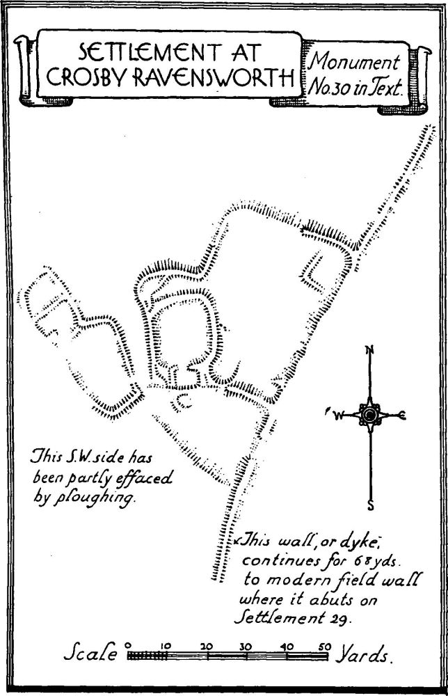
e(30). Village Settlement (900 ft. above O.D.), 300 yards N.E. of (18), is about ¾ acre in extent, and has been much damaged by ploughing. Its outline is irregular and from the southern half of the N.W. side there is a projection of irregular shape. There are indications of an entrance with an internal passage-way at the re-entrant angle. Internally, the enclosure shows traces of the usual irregular subdivisions, while there are suggestions of a roughly square structure in the N.E. corner. The remains are turf-covered.
Settlement at Crosby Ravensworth
Condition—Bad.
e(31). Village Settlement (900 ft. above O.D.), about ½ m. N.E. of (18), is rather over 2 acres in extent and is of irregular form. The main enclosing wall has been much destroyed in places by the modern field-wall on the N.E. and is also much obliterated on the S.W. As a result it is impossible definitely to identify the entrances, but there are suggestions of one on the S.W. where there is an unusually large orthostat. Internally there are suggestions of some circular huts and the usual cattle-pens and enclosures.
Condition—Bad.
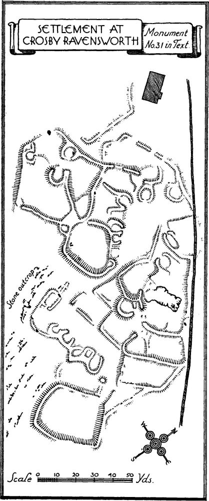
Settlement at Crosby Ravensworth
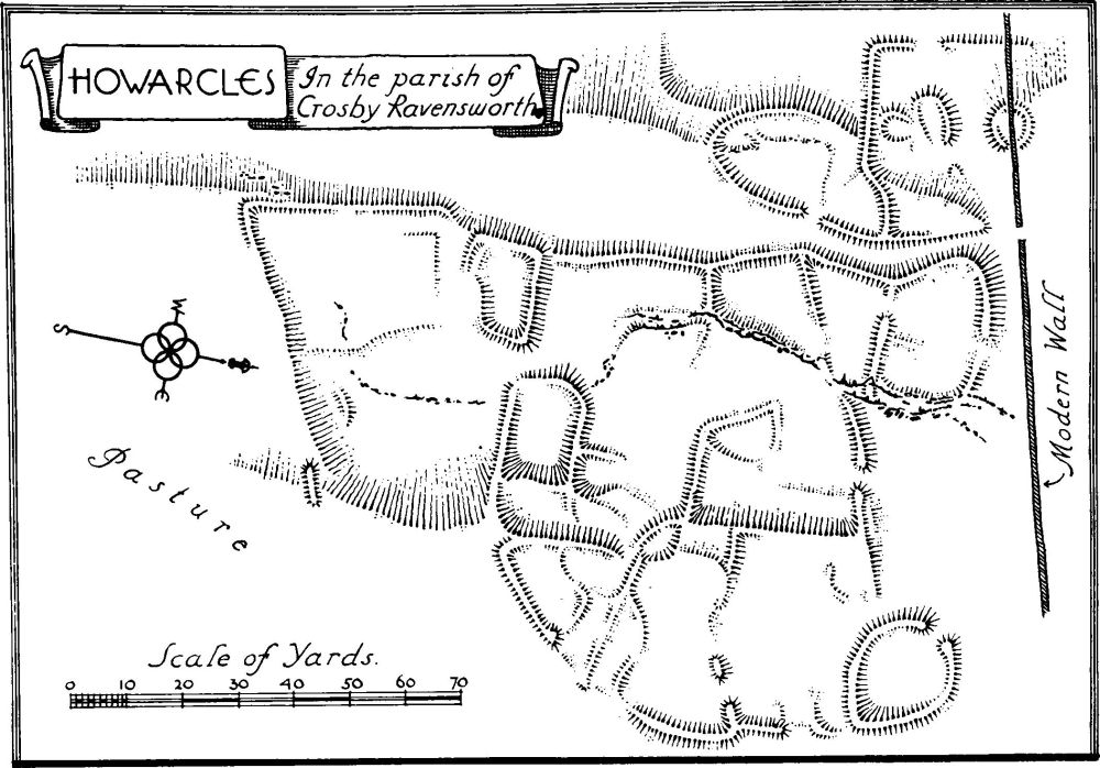
Howarcles, in the parish of Crosby Ravensworth
c(32). Ravens Gill, village settlement (850 ft. above O.D.), on the E. side of Gilts Lane, 1½ m. S. of the church, consists of a heterogeneous collection of banks, small quarryings, etc. It is impossible to determine which banks may have belonged to a settlement and which may be spoil from the quarryings. The latter have destroyed practically all definite traces of the settlement, with the exception of an irregular ovalshaped enclosure with surrounding bank some 18 yards by 20 yards in extent.
Condition—Bad.
c(33). Howarcles, village settlement (850 ft. above O.D.), 800 yards N. of (32), is over 1¼ acres in extent. The site occupies a shelf on the hill-side and is divided by a road or passage-way, the part to the W. being probably incomplete as now seen. The remains consist almost entirely of irregular enclosures with some smaller ones which possibly represent cattle-pens. Like some other settlements, such as that at Severals in Crosby Garrett, there is a scarcity of circular huts. There is one definite example at the N.W. corner; there is also a very large circular foundation at the N.E. corner, comparable to the large hut at Ewe Close.
Prof. Collingwood suggests that this "may be a very large family farm in which—except for the one outlying hut—everyone lived in the one large building." On the other hand, Severals, which is larger, appears also to be deficient in circular huts. Close to the settlement on the S. are further enclosures which may be of later date. (C. and W. Trans., N.S. XXXIII, 215.)
Condition—Poor.
b(34). Village Settlement (930 ft. above O.D.), S. of Harberwain and ¾ m. W. of the church, consists of slight indications of foundations. In the S. part is a straight line of bank about 3½ ft. high which may be of comparatively late date.
Condition—Bad.
b(35). Village Settlement (1,050 ft. above O.D., called Camp on O.S.), on Wickerslack Moor, nearly 1½ m. W.N.W. of the church, is nearly 1 acre in extent. It consists of a number of circular huts and three irregular enclosures on the E., while the western part is enclosed by a nearly rectangular boundary wall. This becomes indefinite on the N.E. but probably joined up with the eastern portion.
There are two small irregular mounds of about 12 ft. diameter, one immediately S. of the S.W. angle of the settlement and the other about 9 yards W. of the same angle.
Condition—Bad.
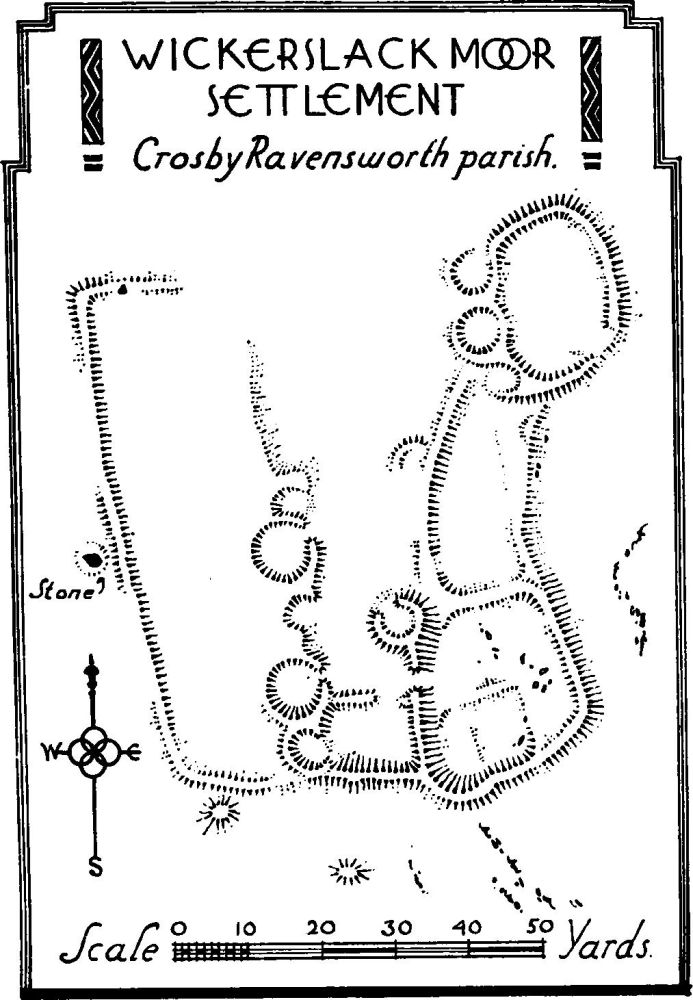
Wickerslack Moor Settlement, Crosby Ravensworth parish.
c(36). Dykes and House-foundations at Crosby Gill and Hazel Moor, 2 m. S.S.W. of the church. The main dyke encloses a considerable area, the exact size of which cannot be stated as most of the E. side cannot be traced and there is no apparent return on the N. As it exists, the length of the enclosure is at least 1¼ miles, and it is said to have been a deer park. The large number of cross-dykes within the area, however, seems to negative this suggestion. Its position with a ravine running through it and its cross-dykes are very similar to the dyked enclosure at Ravenstonedale. The bank is about 14 ft. wide and the height from 3 to 3½ ft.
Within this enclosure are the foundations of a number of rectangular buildings:—
(a) A two-roomed building (Plan, p. xlvi), immediately S. of (27), the larger room 30 ft. by 16 ft. and an annexe 13 ft. square at the E. end. The room has a three-sided W. end roughly segmental in form. The walls, 3½ ft. thick, have orthostats. Prof. Collingwood (C. and W. Trans., N.S. XXXIII, 211) suggests that this is the Scandinavian or Teutonic type of house.
(b) A two-roomed building, similar to and 100 yards W. of (a), has a room 22 ft. by 14 ft. and an annexe 10 ft. by 13 ft.
(c and d) Remains of similar buildings, (c) 140 yards S. of (b), and (d) 110 yards W.S.W. of (c).
(e) Rectangular building, ¾ m. S. of (d) and 200 yards W.N.W. of King's Well, is about 42 ft. by 10 ft.
(f) Rectangular building, 130 yards W.S.W. of (e), is about 30 ft. by 13 ft.
Condition—Of dyke—fairly good.
c(37). Enclosure, 400 yards W.S.W. of (26), is of roughly oval form, 42 ft. by 24 ft. The wall-foundations are visible and incorporate a large boulder.
Condition—Fairly good.
c(38). Circular Foundation or enclosure, 460 yards N.W. of Oddendale, is about 36 ft. in internal diameter and has a slight sinking in the middle.
Condition—Poor.
b(39). Enclosure, in Scar Plantation, 2 m. W.N.W. of the church, is of rhomboidal form, about 35 ft. by 27 ft. The foundations incorporate some large boulders.
Condition—Poor.
d(40). Enclosure or building, on Crosby Ravensworth Fell, 3½ m. S.S.W. of the church and 320 yards S. of Howenook Pike, is 20 ft. square with slightly rounded angles.
Condition—Poor.
d(41). Cairn on Howenook Pike, 320 yards N. of (40), is 20 ft. in diameter and 3½ ft. high.
c(42). Cairn on Long Scar Pike, over 3 m. S.W. of the church, is about 60 ft. in diameter and 7 ft. high.
c(43). Mound (called Tumulus on O.S.), E. of Wicker Street and ¾ m. W.S.W. of (27) is 36–38 ft. in diameter and 3 ft. high. There has been some disturbance in the middle.
c(44). Stone circle on White Hag, 400 yards E.S.E. of (43), consists of eleven granite boulders, all fallen.
c(45). Cairn (called Tumulus on O.S.), 320 yards E.S.E. of (44), is of oval form, 32 ft. by 28 ft. and 4 ft. high. It has been disturbed in the middle.
c(46). Mound of long-barrow form, 175 yards S.S.W. of (27), is of piled stones partly turf-covered. It is 87 ft. long and tapers from 49 ft. (at the E. end) to 25 ft. in width.
c(47). Cairn, 100 yards S. of (28), is of irregular form, 21 ft. by 30 ft. and 1½ ft. high.
c(48). Cairn (called Tumulus on O.S.), ¼ m. S.E. of (28), is about 63 ft. in diameter and 5½ ft. high.
e(49). Mounds (called Tumuli on O.S.), on the E. bank of Ravens Gill opposite (18), are four in number: (a) 150 yards N.N.E. of (18), oval in form and 34 ft. by 27 ft. and 4½ ft. high; (b) 55 yards S.S.E. of (a), oval in form and 21 ft. by 24 ft. and 2½ ft. high; (c) 40 yards S.E. of (b), oval in form and 32 ft. by 27 ft. and 3½ ft. high; (d) 24 yards S.W. of (c), circular, 24 ft. in diameter, and 2½ ft. high.
d(50). Robin Hood's Grave, cairn on the N. edge of Crosby Ravensworth Fell, 2¾ m. S. of the church, has been robbed of much of its stone.
f(51). Tumulus, at Penhurrock, 1,600 yards S.S.E. of (18), has been largely removed and now consists only of scattered stones and a few large boulders. It was probably about 55 ft. in diameter, as indicated by remains of a ring of stones round the base. It has been excavated and burnt bones found. (C. and W. Trans., O.S. VI, 179.)
e(52). Cairns (called Tumuli on O.S.) on Gaythorn Plain, 2½ m. S.E. of the church, are two in number, the more westerly 25 ft. in diameter and 2 ft. high, and the second 100 yards W.N.W., 34 ft. in diameter and 3 ft. high. Both were excavated by Greenwell and each had a ring of stones round the base; the first had the unburnt body of an adult and the second the scattered bones of two males. At a level 1¾ ft. higher was a secondary interment consisting of an urn (now in Brit. Mus.) with the burnt remains of an adult. (Brit. Barrows, Nos. CLXXX and CLXXXI.)
e(53). Mound (called Tumulus on O.S.) at Raise Howe, 1½ m. S.E. of the church, is 45 ft. in diameter and 3 ft. high. It has been badly damaged by excavation.
c(54). Cairn, N. of Potrigg and 2¼ m. S.W. of the church, was about 17–18 ft. in diameter and 1½ ft. high. About half of it has been removed.
c(55). Stone Circle (so marked on O.S.), 600 yards S.S.W. of Oddendale, consists of a mound about 1 ft. high with a small surrounding circle of stones and an outer circle of 34 boulders, 90 ft. in diameter and 30 ft. beyond the inner circle. It was excavated by Simpson and burnt matter was found in the middle (C. and W. Trans., O.S. VI, 178).
c(56). Cairns (one called Tumulus on O.S.), near Seal Howe, are two in number. The first is 400 yards E.S.E. of (55) and is 35 ft. in diameter and 3 ft. high; a bield has been built on the top. It was excavated by Greenwell, who found a primary unburnt burial of a man on the rock surface and, S. of it, a secondary burial consisting of an urn with burnt remains of a woman and an infant (Brit. Barrows, CLXXXII). The second cairn, 150 yards N.E. of the first, is 30 ft. in diameter and 3½ ft. high.
c(57). Cairn, ¼ m. S. of Lane Head (15), is 20 ft. in diameter and 2½ ft. high. It was excavated by J. Moss, who found some small disc-shaped beads of lignite or shale (now in Brit. Mus.), fragments of pottery and unburnt bones (Proc. Soc. Ants., VII, 214).
b(58). Mounds (called Tumulus and Stone Circle on O.S.), at Iron Hill, over 1½ m. W. of the church, are two in number. The more northerly is 42–45 ft. in diameter and 3 ft. high and has remains of a ring of large boulders round the base. The second, 60 yards to the S., is about 30 ft. in diameter and 1 ft. high, and has a ring of large stones round the base. One of these mounds has been excavated and found to contain the bones of a man, part of a deer-antler and animal bones (Arch. Journ., XVIII (1861), 36).
b(59). Stone Circle, on the W. boundary of the parish, 250 yards E.S.E. of Castlehowe Scar and over 2 m. W. of the church, consists of one fallen and ten standing granite stones with a diameter of about 16 ft.
b(60). Mound, 40 yards W. of (35), is about 35 ft. in diameter and 2 ft. high.
b(61). Mound (called Tumulus on O.S.), about 200 yards S.W. of (34), is about 40–42 ft. in diameter and 2 ft. high.
a(62). Mound (called Tumulus on O.S.) on the W. side of Lyvennet Beck and 1¾ m. N. of the church, is 31–32 ft. in diameter and 3½ ft. high. There are traces of a ring of boulders round the base, but the mound has spread beyond them. The top has been disturbed.
c(63). Mound, 230 yards N.W. of (32), is about 30 ft. in diameter and 3 ft. high. The top has been disturbed and two stones of a cist are visible.
c(64). Lynchets, 300 yards W. of (14) and 1¼ m. W.S.W. of the church, on ground falling towards the S.E.
c(65). Field System, on Dale Moor (1,100 ft. above O.D.), 2 m. S.W. of the church, covers a considerable area. There are traces of walled fields averaging about an acre each and of roughly square form.