An Inventory of the Historical Monuments in Westmorland. Originally published by His Majesty's Stationery Office, London, 1936.
This free content was digitised by double rekeying. All rights reserved.
'Grasmere', in An Inventory of the Historical Monuments in Westmorland(London, 1936), British History Online https://www.british-history.ac.uk/rchme/westm/pp96-99 [accessed 30 April 2025].
'Grasmere', in An Inventory of the Historical Monuments in Westmorland(London, 1936), British History Online, accessed April 30, 2025, https://www.british-history.ac.uk/rchme/westm/pp96-99.
"Grasmere". An Inventory of the Historical Monuments in Westmorland. (London, 1936), British History Online. Web. 30 April 2025. https://www.british-history.ac.uk/rchme/westm/pp96-99.
In this section
32 GRASMERE (B.d.)
(O.S. 6 in. (a)XVIII, N.E., (b)XVIII, S.E., (c)XIX, S.W., (d)XXV, N.E., (e)XXVI, N.W.)
Grasmere is a parish and village on the N. side of Grasmere lake and 3 m. N.W. of Ambleside. The church is the principal monument.
Ecclesiastical
e(1). Parish Church of St. Oswald stands in the village. The walls are of local rubble with freestone dressings and the roofs are slate-covered. The church consisting of Chancel, Nave and West Tower seems to have been re-built in the 14th century. The N. arcade was built and the North Aisle and South Porch added perhaps c. 1562 under the terms of the will of John Benson. The upper arcade was built and the roofs altered probably in the 17th century. The church was restored in 1851 and other dates in the 19th century, and the E. wall of the chancel and aisle re-built.
The two-storeyed arcade is an unusual feature and among the fittings the poor-box is noteworthy.
Architectural Description—The Chancel (32 ft. by 21 ft.) has a modern E. wall and window. The 16th-century N. arcade (Plate 11), continued down the nave, is of five bays with plain elliptical arches, some of which are slightly pointed, and plain rectangular piers and responds; the piers have traces of imposts on the N. and S. faces; four shaped corbels above the arcade indicate the level of the former roof; the 17th-century upper arcade is of four bays set over the piers below; the plain arches are segmental and spring from rectangular piers; this arcade-wall is not carried to its full height up to the E. and W. walls of the church, to allow of the insertion of a window at each end. In the S. wall are two modern windows and between them a doorway of uncertain date with chamfered jambs and two-centred arch. There is no chancel-arch.
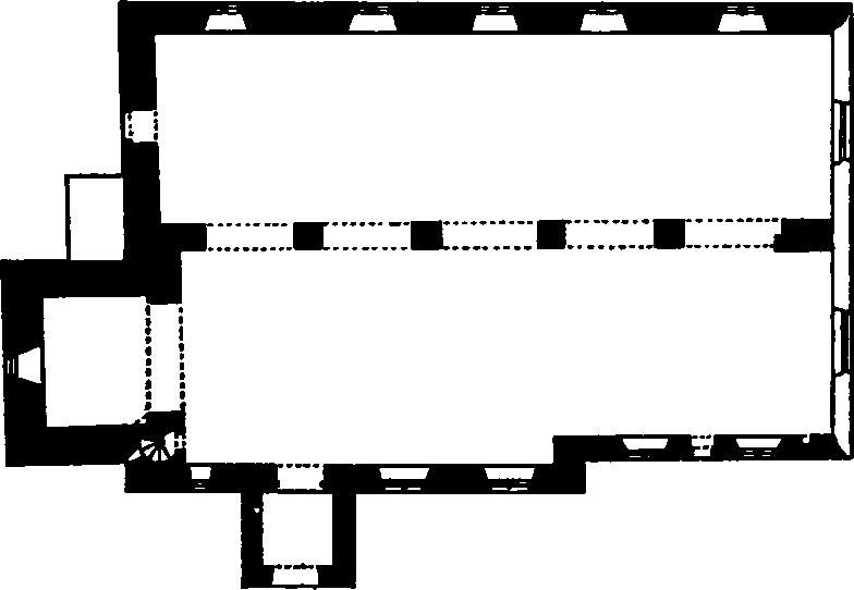
The Church, Plan
The Nave (42½ ft. by 24½ ft.) has, in the S. wall, three windows, the two eastern modern and the westernmost of the 14th century and of one trefoiled light; the featureless S. doorway has plain jambs and two-centred arch.
The North Aisle (21½ ft. wide) has a modern E. wall and window. In the N. wall are five two-light windows, of 16th-century origin but all restored. In the W. wall is a re-set doorway, possibly of the 14th century, with chamfered jambs and two-centred head; farther S. and high in the wall is a 16th-century window of two square-headed lights and incorporating 14th-century material.
The West Tower (12¼ ft. by 15 ft.) is of three stages with an embattled parapet; it is possibly of the 14th century, but retains little evidence of date. The two-centred tower arch is of one plain order with responds of the same section and mutilated imposts. The W. window is modern. The second stage has a modern window in the S. wall. The bell-chamber has in each wall a plain square-headed window of uncertain date.
The South Porch is perhaps of the 16th century and has a plain square-headed outer archway.
The Roof of the building consists of two series of trusses over the main body and the N. aisle respectively, with a third series of trusses resting on the ridges of the lower series; the two lower series of trusses are of king-post type and of the 16th century, those over the aisle having four-way struts to the king-posts; the top roof is probably of the 17th century and has raking struts to the principals.
Fittings—Books: In vestry—Act for suppressing profane cursing, 1689, printed 1706. In N. aisle—a prayer-book of 1695 and prayers for special occasions, 1665. Brasses: In chancel—on E. wall, (1) to William Fleming, 1653, inscription only; (2) to Barbara (Fletcher), wife of Daniel Fleming, 1675, inscription only. Chairs: In chancel—two (Plate 39), with panelled and carved backs, cresting, shaped arms and turned front legs, one with initials and date I.L. 1677, the other M.B. 1703. Chest: In tower—plain, with three strap-hinges, late 17th-century. Font: octagonal cup-shaped bowl (Plate 43) with rolls at the angles, probably mediæval; plain octagonal stem tapering upwards and three steps, 17th-century. Glass: In E. window—fragments, including tabernacle-work and one with the words "Gracia tibi," 15th and 16th-century. Monument: In chancel—on N. wall, to Sir Daniel Fleming, 1701, white and grey marble tablet (Plate 45) with Doric side-pilasters, entablature and broken pediment. Piscina: In chancel—recess with trefoiled head and projecting octagonal drain, 14th-century, re-cut. Plate: includes two cups without datemarks but both dated 1714, and one of them given by Dorothy Benson. Poor-box: In chancel—of oak (Plate 60) with enriched wall-piece with the name S. Oswaldus above, enriched box with moulded top and a cartouche with the date 1648; on top of box the words "Poor box." Recess: In S. porch—in W. wall, square-headed recess. Seating: In nave—at W. end, two bench-ends with rounded top and the date 1635. Miscellanea: Over second pier of arcade, head-corbel found in E. wall, probably 14th-century. In tower— stone (Plate 5) with round-headed panel in each face, two filled with foliage, one with a monster and one with the standing figure of a man holding a sword, late 12th-century.
Condition—Good.
Secular
b(2). New Bridge, over Easedale Beck about ¾ m. N.W. of the church, is of the pack-horse type. It has a single segmental arch with long rubble voussoirs and is about 8 ft. wide. It dates probably from the 17th century.
Condition—Good.
b(3). Willy Goodwaller Bridge (Plate 28), over Far Easedale Gill, about 1¼ m. N.W. of the church, is of similar date and type to that last described. It is 11½ ft. wide and the rubble voussoirs rise above the level of the trackway.
Condition—Good.
a(4). Bridge at Dunmail Raise, about 2¾ m. N.W. of the church, has modern widenings on both sides. The old portion, probably dating from the 17th century, forms a section about 14½ ft. wide in the middle of the bridge and is a rubble arch of segmental form.
Condition—Good.
Monuments (5–50)
The following monuments, unless otherwise described, are of the 17th century and of two storeys. The walls are of rubble and the roofs are slate-covered. Some of the buildings have exposed ceiling-beams and cylindrical chimney-stacks.
Condition—Good or fairly good, unless noted.
d(5). Parish Hall, formerly a barn, adjoining the rectory and 50 yards S.S.W. of the church. A loose ceiling-beam bears the inscription "This house was built 1687 Henry Fleming Par(son)".
d(6). House and shop, 50 yards N.W. of the church, retains an original window, with a solid frame, in the E. wall.
e(7). Cottage, formerly school, at the N.E. angle of the churchyard, is of one storey. The windows in the S. wall have original solid frames.
d(8). Moss Side, house, 175 yards N.W. of the church, contains some late 17th-century panelled doors and a panelled cupboard of the same date.
d(9). House, 20 yards W. of (8).
d(10). Red Lion Hotel, 200 yards N.W. of the church, has been extensively modernised.
d(11). Crag Cottage, 325 yards N.W. of the church, contains a panelled cupboard with the initials and date I. and P.M. 1705. There is also a muntin and plank partition of the local type.
d(12). Under Howe, house, immediately E. of (11), was built c. 1600 and extended N.E. late in the 17th century. There is a porch on the S.E. side. Inside the building is an original panelled door with strap-hinges.
d(13). Dockwray, house, 350 yards N. of the church, has an original nail-studded S. door and a muntin and plank partition of the local type.
e(14). Dove Cottage, at Town End, 625 yards S.E. of the church, was once occupied by Wordsworth and is now kept as a museum. The N.E. part is probably a late 17th-century addition and the N.W. block is an addition of the 18th century. The S.E. room is lined with early 18th-century panelling and the staircase has 17th-century handrails and newel.
e(15). House and barn, 20 yards S. of (14), contains a muntin and plank partition and another of panelling, said to have come from the church.
e(16). Cottage, four tenements, 20 yards S. of (15), was built c. 1700.
e(17). Barn, on the island in Grasmere, is of one storey with a number of loop-lights.
d(18). Dale End, house and outbuilding, ¾ m. S. of the church. The House was built by John Benson in 1661, and has modern additions on the N. and W. The date is recorded on a modern panel over the E. door. The staircase has a panelled dado of c. 1700. The house contains much carved woodwork not native to the county. The Stable and barn, S.W. of the house, bears the initials and date I.B. 1661.
d(19). Cottage and barn, at the Wyke, 1,000 yards S.W. of the church. The Cottage retains some original windows with solid frames. The Barn, S.W. of the cottage, is of two bays.
d(20). The Wray, house, 600 yards W.S.W. of the church, is perhaps partly of the 16th century but has been much altered.
d(21). Pavement End, house, 300 yards W.S.W. of the church.
b(22). Low Scorecrag, house and barn, ½ m. N.W. of the church. The House was built c. 1600 and retains a small original window with a solid frame. Inside the building are some 17th-century panelled doors. The Barn, S. of the house, has loop-lights and some original partitions.
b(23). High Scorecrag, house, 100 yards W. of (22), was built c. 1600 and retains a window with an original solid frame. Inside the building is a three-stage cupboard (Plate 34) of the local type with projecting top, pendants and the initials and date I.M. (Mackereth) 1714 on the cornice. The stabling retains its original partitions and there is a small outbuilding S.W. of the house, probably of the 17th century.
b(24). Lowfold, house and barn, 950 yards N.W. of the church. The House retains some original partitions of the local type. The Barn adjoins the house on the N.E.
b(25). Goodybridge Farm, house, 20 yards N.E. of (24), contains some original partitions of the local type.
b(26). Goodybridge House and barn, 1,000 yards N.W. of the church. The House contains a late 17th-century staircase with turned balusters and panelled newels; there are some doors of the same date. The Barn, N.E. of the house, is a one-storey building of four bays with a roof of crutch-construction. It is perhaps of mediæval date.
b(27). Thorny Howe, house, ¾ m. N.W. of the church, has 18th-century and modern additions. Adjoining the house on the N.W. is a barn of four bays.
b(28). Lancrigg, house and outbuilding, 150 yards W.N.W. of (27). The House has been extensively enlarged in modern times. The Outbuilding, W. of the house, consists of a barn with an added 18th-century wing.
b(29). Underhelm, house, 250 yards N.E. of (28), is perhaps of 16th-century origin.
b(30). Underhelm Cottage, immediately N.W. of (29).
b(31). Barn at Kittycrag, 1,550 yards N.W. of the church, is a one-storey building with loop-lights.
b(32). Easedale House Cottage, 50 yards N.W. of (31), retains an original nail-studded door.
b(33). Brimmer Head, house, about 1 m. N.W. of the church, is perhaps of 16th-century origin and has modern additions. The N. wing retains a 17th-century window with a solid frame. Inside the building the mid 17th-century staircase has symmetrically turned balusters and a moulded newel with a ball-terminal. There are some doors and partitions of the same period and a small cupboard with the initials and date T.M.W. 1693.
b(34). Blindtarn Gill, house and barn, 330 yards S.S.W. of (33). The House may be of 16th-century origin and has remains of an external staircase. The Barn, S. of the house, is probably of the 17th century.
b(35). Barn at High Easedale, nearly 1½ m. N.W. of the church, is a small structure of three bays with loop-lights.
b(36). Low Broadrain, house, about 1¼ m. N. of the church, has a staircase-wing on the E. side.
b(37). High Broadrain, house, 110 yards N.N.W. of (36), is perhaps of 16th-century origin. It retains a 17th-century window with a solid frame.
b(38). Gill Foot, house, 370 yards W.N.W. of (37).
b(39). Cottage at Turn Howe, nearly 1¾ m. N.N.W. of the church.
b(40). Turn Howe, house, 40 yards W.N.W. of (39), is perhaps of late 16th-century date. It contains some muntin and plank partitions (Plate 59) of the local type and two windows retain their original solid frames. The staircase has moulded flat balusters and newel.
b(41). Town Head, house (Plate 22) and outbuildings, 320 yards E. of (40). The House contains a small cupboard with the initials and date W.H.A. 1702. There are also some original partitions of the local type. The Outbuilding adjoining the house on the N.E. and a second to the S.E. are both of the 17th century.
b(42). Town Head Cottage, 20 yards N. of (41), has a plaster panel on the E. wall with the date 1638. Inside the building are some original panelled partitions and doors. A panelled cupboard has the initials and date W.H. 1707.
Condition—Poor.
c(43). Gillside, house, 1¼ m. N. of the church, is perhaps of 16th-century origin.
c(44). Cottage at Winterseeds, ¼ m. S. of (43), contains a panelled cupboard of the local type, with the initials and date T.H.M. 1708. The staircase-window has an original solid frame.
c(45). Cottage, 10 yards S.W. of (44).
c(46). Cottage, two tenements, at Knott Houses, ¾ m. N. of the church, retains an original window with a solid frame and some muntin and plank partitions of the local type.
c(47). Knott Houses Farm, house and barn, 70 yards E. of (46). The House has some original windows with solid frames and partitions of the local type. A small cupboard has the initials and date I.A.M. 1704.
c(48). Barn at St. Michael's Fold, 350 yards S.S.E. of (47), is of one storey with a modern extension on the N.
c(49). Ben Place, house, 1,000 yards N.E. of the church, has been extensively modernised.
c(50). Forest Side Cottage, 40 yards E. of (49), contains a panelled cupboard of the local type, with the initials and date G. and C.F. 1704.
Unclassified
a(51). Cairn on the W. side of the road at Dunmail Raise on the county boundary at the N. end of the parish. The stones forming the cairn were displaced when the road was made in 1891 and subsequently replaced in what was considered their original arrangement.