An Inventory of the Historical Monuments in City of York, Volume 1, Eburacum, Roman York. Originally published by Her Majesty's Stationery Office, London, 1962.
This free content was digitised by double rekeying. All rights reserved.
'Roman York: Approach Roads', in An Inventory of the Historical Monuments in City of York, Volume 1, Eburacum, Roman York(London, 1962), British History Online https://www.british-history.ac.uk/rchme/york/vol1/pp1-4 [accessed 30 April 2025].
'Roman York: Approach Roads', in An Inventory of the Historical Monuments in City of York, Volume 1, Eburacum, Roman York(London, 1962), British History Online, accessed April 30, 2025, https://www.british-history.ac.uk/rchme/york/vol1/pp1-4.
"Roman York: Approach Roads". An Inventory of the Historical Monuments in City of York, Volume 1, Eburacum, Roman York. (London, 1962), British History Online. Web. 30 April 2025. https://www.british-history.ac.uk/rchme/york/vol1/pp1-4.
In this section
The Roman Monuments in the City of York an Inventory
(The Normal National Grid References are in 100-kilometre square SE and are distinguished by the letters N.G.)
Approach Roads
The Roman road system of which York, EBVRACVM, was the centre is described in general terms in the Introduction (see p. xxx). The following entries, Nos. 1–11, include reasoned accounts of the course of the individual roads and detailed descriptions of their remains, beginning in each entry at or near the modern city boundary and proceeding inwards to the centre of York as far as the bounds of the fortress (Fig. 2). For clarity the designations Road 1, Road 2, etc., are used throughout the Inventory in preference to Monument 1, Monument 2, etc. The streets within the fortress (Monument 12) and the fortified enclosure (Monument 13) and the minor streets within the built-up area of the civilian settlement are described under those heads, those in the fortress under their Roman names, those in the civil town (colonia) under Monument 17 (a–d); other minor remains are included under Monuments 38, 39, 44.
Road 1, approaching York from the S.E., is last known 650 yds. S.E. of the city boundary. From Pool Bridge (N.G. 642462) to Germany Beck (N.G. 622494) the line of it is represented by a parish boundary running straight for 23/8 m. and aligned upon where the S.E. gate of the fortress stood. This line produced crosses the city boundary about 70 yds. E. of the junction between Mitchel's Lane and Heslington Lane (N.G. 618499) and joins Road 2 E. of the river Foss.
Road 2, approaching York from the E., eventually from Brough, PETVARIA, and the Humber crossing, and from the E. coast via Stamford Bridge, joins the city boundary along the Hull Road, W. of Gallows Hole (N.G. 630513). Short of the boundary it is visible as a soil mark S. of the Hull Road on an R.A.F. air-photograph (1/5000–58/899, prints 5252–3) from N.G. 631513 to N.G. 633512. Within the city boundary its course lay mainly just N. of the Hull Road, converging again on the modern road in Lawrence Street. Here in 1954 the road was seen 6 ft. below the modern surface in a sewer trench 300 ft. from Walmgate Bar on the N. side of the street (N.G. 61175139); it was composed of cobbles set in clay. Nearer the Bar it was seen in 1915 (G. Benson, York II, 162) 5 ft. deep.
This road is usually said to have turned northwards at or near where Walmgate Bar now is and made direct for the S.E. gate of the fortress (King's Square). This may have been the course at one period, but the road has not been found on this line and there is evidence for another course. The alternative is that the road continued on the E.-W. alignment to a crossing of the Foss (behind the Castle Museum), then turned N.W. (through Castle Yard) to pass in front of the S.W. side of the fortress to the S.W. gate and the main Ouse crossing; that is, in terms of modern topography, it followed approximately the line of Castlegate, Spurriergate and Coney Street. In 1959 a cambered Roman road was found in Spurriergate (N.G. 603517) on this line, 25 ft. to 30 ft. wide and composed of limestone chippings and gravel 3 ft. thick (see Monument 39). On the S.W. side, but in the road material, was a water main consisting of timber pipes jointed with iron collars; one of these last survived and with it was a cooking pot of the 2nd-early 3rd century. The road overlay a building with cobble foundations for the outer walls and timber party-walls (Monument 39(i). Plate 25. Fig. 49); it had therefore clearly been constructed anew on this site, but while seemingly there must have been an earlier road in from Brough no trace of it has been found nearby to the N.E.; close S.W. the ground has not been examined, thus, if it did not follow a completely different line, it may have lain here.
Road 3, approaching York from the E., from the direction of Stamford Bridge, direct from Gate Helmsley via Brockfield and Turkers Wood (N.G. 655546), where there are clear indications of it on the ground surface in the form of a ridge, was verified by excavation in 1959 N. of Appletree Farm, about ½ m. outside the city boundary (N.G. 632531) (JRS, L(1960), 219). Its course within the city is not known. The last known alignment would cross the boundary E. of Hempland Lane near N.G. 623530. The road may then have continued to join Road 4 in Heworth Green (Stockton Lane end) or turned S. to pass alongside the fortress and join Road 2 near Ousegate.
Road 4, approaching York from the N.E., possibly from Malton, DERVENTIO, may, in modern topographical terms, have crossed the city boundary with Stockton Lane (N.G. 625533). The early 18th-century road from Malton following the line of the present Stockton Lane was believed by F. Drake (Eboracum (1736), 36) to follow the course of a Roman road. This is a likely line but awaits proof. Within the city it would pass S. of Stockton Lane, with a change of alignment near Whitby Avenue, to converge on the Lane near its junction with Heworth Green. Here in Stockton Lane a cobbled causeway was found 2 ft. to 3 ft. deep in 1926; but it was only 9 ft. wide. Heworth Green, aligned on where the N.E. gate of the fortress stood, represents the Roman line. After crossing Monk Bridge, the modern road, Monkgate, bears S. to Monk Bar. Three finds of the Roman road, listed below, though not exactly sited, are described in terms consistent with their being on the continuation of the line of Heworth Green. G. Benson (York I (1911), 79) records a buried road 6 ft. deep in Monkgate, F. Drake (Eboracum, 37) a firm stone causeway 8 ft. deep N. of Monkgate, C. Wellbeloved (Eburacum (1842), 54) a paved road near the N.E. gate of the fortress. The finds, if they all belong to the same road, can only be reconciled with a line from the N.E. gate converging on Monkgate near Monk Bridge.
Road 5, from the N.W., enters the city at a point 275 ft. S. of Shipton Road (N.G. 588533). Its course from the lane at the back of the Homestead Gardens to Water End (N.G. 58955315 to N.G. 59135291) was formerly marked by a parish boundary, now obsolete (see 60 ins. O.S. (1853), Sheet 4) but the laying out of the Gardens has obliterated both road and boundary. Opposite the entrance to the Gardens in Water End the road was exposed in 1893 in a sewer trench at a depth of 1½ ft. (O.S., Object Namebook, Sheet 174 N.W. plan 6, 137); it was 24 ft. wide. S.E. of Water End the road was marked by another parish boundary, now also obsolete and represented by the boundary between the grounds of Clifton Croft and the back gardens of houses in Westminster Road; this continued the original alignment for 175 ft., then, after a slight change of direction at the N. end of the outbuildings of Clifton Croft (N.G. 59145288), it marked the road for another 690 ft. to N.G. 593527. Some 770 ft. further S.E. on the same alignment the road was found in 1954 in a position 26 ft. N.E. of St. Peter's School Swimming Baths (N.G. 59455256); it was composed of cobbles and clay and approximately 25 ft. wide (YPSR (1954), 13–8). Prolongation of the line would pass through the gateway of St. Mary's Abbey; according to a 13th-century document quoted by T. Widdrington (Analecta Eboracensia (ed. C. Caine, 1897), 121–2), the abbey grounds included the site of an ancient street. The road was clearly designed to pass in front of the fortress, to the S.W. gate and the river crossing before it.
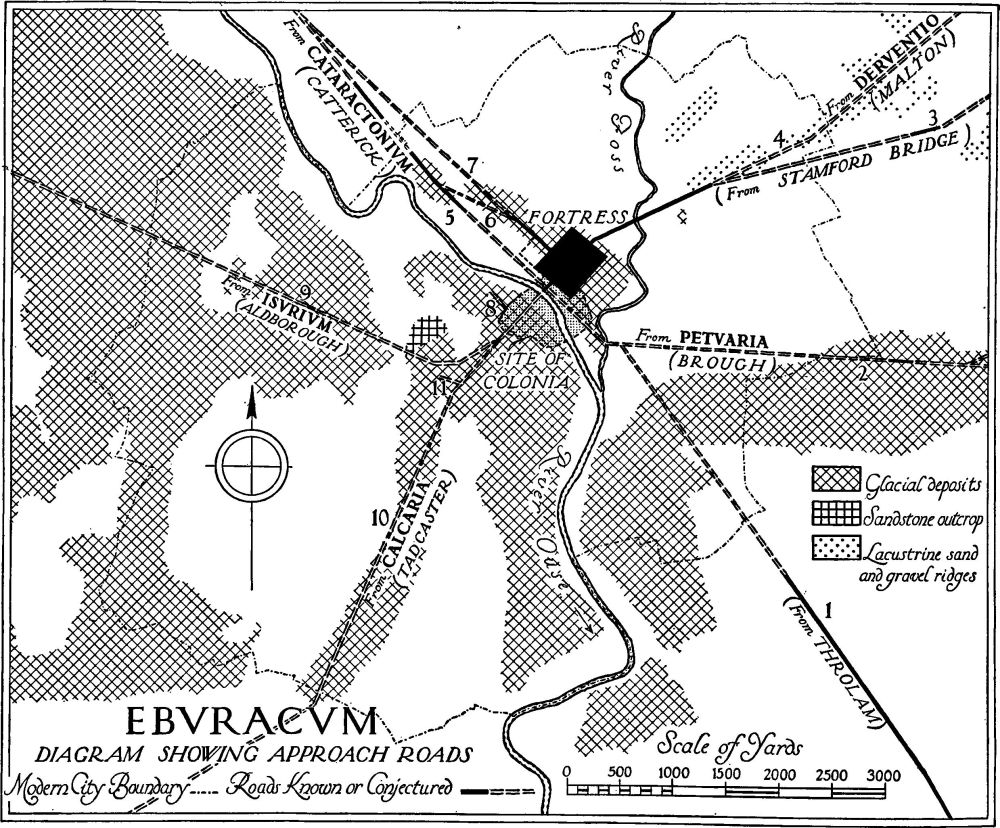
Fig. 2. For cartographical setting, see MAP in pocket at end of book.
Road 6 linked Road 5 with the N.W. gate of the fortress. It probably left Road 5 near to Clifton Croft. 'Concrete' foundations found in 1893 in the Bur Dyke (N.G. 593528), 250 ft. N. of The Avenue, may belong to it. In 1954, in a drainage ditch that cut the road obliquely 70 ft. W. of St. Olave's School (N.G. 595527), it was found to have a basis of heavy cobbles and to have been repaired and widened with building rubble including painted plaster. In relation to modern topography, the road reached Bootham opposite Bootham Terrace (N.G. 598525) where it changed alignment to follow the modern road-line to the N.W. gate of the fortress. During excavation for a sewer in 1893 the road was found at three points: opposite Bootham Terrace the trench cut the road obliquely at the point where it changed direction, thus the width of 33 ft. recorded here is probably generous; opposite St. Mary's Abbey (N.G. 599524) and 90 ft. S.E. of Marygate (N.G. 600523) its N.E. edge was exposed at depths of 6 ft. and 5 ft. respectively, these positions being 20 ft. and 17 ft. respectively S.W. of the modern building-line on the N.E. side of Bootham. The edge was strengthened with piles 3½ ft. long. (O.S., Object Namebook, Sheet 174 N.W. plan 6, 137. References relating to 1/500 O.S. plan 6.14 are lost, but see trace of 1/500 O.S. record plan in the archives of the Yorkshire Museum.)
Road 7 preceded Road 5 on a direct alignment on the N.W. gate from a point well outside the modern city boundary. Evidence for it exists in the obsolete parish boundaries formerly running along Clifton and in a find in 1929 of road-metalling near the fountain on Clifton Green (N.G. 59325302) (O.S., Object Namebook, Sheet 174 N.W. plan 6, 137, note a) and in April 1960 in front of the White House, Clifton (N.G. 59685262).
Road 8 (minor) approached the colonia from the N.W., S.W. of the river. It was found in 1874, in Station Road, 20 yds. to 30 yds. S. of the Cholera Burial Ground (N.G. 59685175). Only 30 yds. of the road were revealed, running in a direction described as a prolongation of Barker and Trinity Lancs, that is, N.W. It was 12 ft. wide, well made of stones, lime, gravel and 'concrete'. On either side were several blocks of wrought stone of uncertain purpose. The road was outside the built-up area of the colonia and ran through a cemetery, to which it may have been an access road (see Burials, IV Region). (J. Raine's Notes in York Public Library, 8; YPS Comms. (1875), 5.)
Road 9, approaching York from the N.W., from Aldborough, ISVRIVM, though last visible as a ridge at the crossing of the river Nidd 8 m. from York, is represented by the modern road A 59 to Foss Bridge and thence S.E. by the service road in front of Burland House to a point 1 m. N.W. of the modern city boundary. Then its course is lost for some two miles. From the Nidd crossing the alignment is consistent on the high ground known as Severus Hills, and here the road is represented by the hedgerow running approximately N.W.-S.E. for 133 yds. on a sharp lynchet from a point 58 yds. S. of the reservoir (N.G. 58015175). Most of the road itself has been destroyed by ploughing in the field on the S.W. or lower side of the lynchet, but in October 1960 the N.E. edge was exposed intact in the lynchet bank; this consisted of a metalling of heavy cobbles cutting into natural clay. Thence the course is in doubt until just outside the built-up area of the colonia, that is, in modern terms, in Blossom Street, behind the Grill Café (N.G. 59655141), where its point of junction with Road 10 was excavated in 1953–4 (Fig. 51). Here it was 35 ft. wide with a ditch on each side and made of clay and cobbles, which sealed a ditch that had been in use until A.D. 180. It approached Road 10 at an acute angle, finally turning 45° to meet it. In the angle was a small cobbled area in which, carefully placed, was a stone base, probably for an altar. (YA and YAS Procs. (1953–4,) 12.) See also Inscriptions etc., No. 144.
Road 10, approaching York from the S.W. from Tadcaster, CALCARIA, crosses the modern city boundary with the present Tadcaster Road S. of the junction of the latter with Sim Balk Lane (N.G. 581483) and the two are coincident as far as the Methodist Chapel, Dringhouses (N.G. 586495). Here they diverge, the modern road making a slight bow to the E. The Roman road continued on its old alignment; as far as the site of the former White House (N.G. 591506: the name is perpetuated in modern street-names on the site) it lies just W. of the modern road. On this line it was found in 1902 in St. Helen's Road (N.G. 587497) (YPSR (1903), 10), and in 1953 part of its cobbling and the ditch on the S.E. side were seen during the building of No. 278 Tadcaster Road (YA and YAS Procs. (1953–4), 10). At the former White House the modern road curves E. to pass the city walls at Micklegate Bar. A similar change in alignment must have been made by the Roman road, though whether this occurred in the same zone is uncertain for the exact line of it is not known for more than ½ m. N.E. from the former White House. In 1879 it was found, composed of cobbles laid on 'concrete', N.W. of Blossom Street, under No. 1 The Crescent (N.G. 59585132). On the opposite side of The Crescent it was again seen in 1936 during the building of the Odeon Cinema (N.G. 596514). In 1953 the road was sectioned 40 yds. N.E. of the Odeon, behind the Grill Café (N.G. 59655141); it was 30 ft. wide and consisted of a basis of clay and cobbles dug into the subsoil with two further layers of carefully laid cobbles above; a cremation in a pot of rusticated ware of c. 80 A.D. alongside suggested that the road dated from the earlier years of the Roman occupation of York (see Burials, IV Region, (k), ii). The positions of these three discoveries fix the alignment of the road from Blossom Street to the river Ouse; the road crossed where the mediaeval wall stands some 130 ft. N.W. of Micklegate Bar (N.G. 597515), passed S. of Toft Green, crossed Tanner Row diagonally a little W. of Rougier Street (N.G. 599517), where it was found in the 19th century (60 ins. O.S. (1853), Sheet 11), passed under the Ebor Café and reached the river opposite the Guildhall where in 1893 the head of the Roman bridge, consisting of 'masses of the strongest stonework', was discovered (YPSR (1893), 8). On the N.E. bank of the river the pavement of the road leading to the S.W. gate of the fortress has been found several times. The junction with Road 2 from Brough, PETVARIA, and Road 5 from the N.W. lay outside the fortress, between the river and the gate. (YA and YAS Procs. (1953–4), 24–31, 57–61.)
Road 11 (minor) joined Road 10 from the W. in or near Dalton Terrace. Finds of cobbling in a former market garden behind Mount School (N.G. 592511) and in Dalton Terrace (N.G. 593511) possibly indicate a road, about 10 ft. wide (YAJ, XXXIX (1958), 289, 305).

Fig. 3.