A History of the County of Stafford: Volume 14, Lichfield. Originally published by Victoria County History, London, 1990.
This free content was digitised by double rekeying. All rights reserved.
'Lichfield: The 20th century', in A History of the County of Stafford: Volume 14, Lichfield, (London, 1990) pp. 32-36. British History Online https://www.british-history.ac.uk/vch/staffs/vol14/pp32-36 [accessed 4 May 2024]
THE 20TH CENTURY
In the 20th century, and especially in the years since the Second World War, Lichfield has developed as a residential area, with extensive light industry and a growing emphasis on tourism. There has been a corresponding growth in the city's population, which nearly tripled between 1951 and the later 1980s. Many commute to work outside the city.
In 1905 houses were being built in Frenchman's Lane, evidently the later Cherry Orchard, (fn. 1) and between 1905 and 1908 houses were built in Ivanhoe Road, a new road linking Birmingham Road and Chapel Lane. (fn. 2) About the same time houses were built at the west end of St. Chad's Road, the renamed Reservoir Road. (fn. 3) Under the Housing Acts of 1919 and the 1920s the council erected 208 houses, including the Christ Church Gardens estate off Christchurch Lane (completed 1921), Beacon Gardens off Beacon Street (1925), houses in Hobshole Lane (later Valley Road) and Trent Valley Road (1927), and the Dovehouse Fields estate west of Chapel Lane (completed 1931). There was also council building in the Dimbles area on the north side of the city which continued during the 1930s. (fn. 4) By the mid 1930s there had also been extensive private building, including houses in Stafford Road, Nether Beacon off Beacon Street, Walsall Road, and the newly laid-out Friary area. (fn. 5)
The 11½-a. Friary estate was presented to the city by Sir Richard Cooper, Bt., in 1920, primarily for building a new road to relieve traffic congestion and also to provide an open space in the city centre. The gift, in the words of a city alderman in 1928, 'let daylight into Lichfield'. That year a new road, the Friary, was opened from Bird Street to the Walsall and Birmingham roads, Sir Richard having contributed towards the building cost. (fn. 6) At the same time the clocktower of 1863 at the junction of the new road and Bird Street was re-erected on the new roundabout at the west end of the road. (fn. 7) The house on which the estate centred was incorporated in new buildings for the girls' high school. (fn. 8) The site of the medieval friary church was excavated in 1933, and the foundations were left exposed as part of an open space. (fn. 9) The area covered by the estate formed a civil parish, which was added to St. Michael's in 1934. (fn. 10) In 1931 it had a population of one, the occupant of a gardener's cottage, (fn. 11) but that year the building of houses was begun along the new road; Friary Avenue, linking the road with Birmingham Road, was also built in the 1930s. (fn. 12) Victoria hospital was built west of the area in 1933. (fn. 13) The stretch of the Friary between the Walsall and Birmingham roads was renamed Friary Road in 1954. (fn. 14)
The outbreak of the Second World War in 1939 was followed by a suspension of building. The number of evacuees who came to Lichfield, over 2,000 at the end of 1940, caused overcrowding, (fn. 15) and a further problem was caused by Jewish tailors evacuated from London who were unable to find work. (fn. 16) There were air raids in 1940 and especially 1941; although only three people were killed and two houses destroyed, 390 houses were damaged. (fn. 17) In 1941 a British Restaurant known as the Civic Café was opened in the Methodist Hall in Tamworth Street as a wartime measure to provide cheap midday meals. At its peak it served over 450 meals a day, and by the time of its closure in 1945 it had served some 400,000 meals. (fn. 18)
With the end of the war in 1945 the council at once resumed house building, and by June 1950 it had built 301 more houses. The first privately built houses were six in Gaia Lane, begun in 1946, and 71 such houses had been completed in the city by June 1950. In 1956 the council agreed to provide 1,200 dwellings for families from Birmingham. (fn. 19) During the 1960s the north and east sides of the city between Stafford Road and Trent Valley Road were filled with new estates, private as well as council and containing high-rise blocks of flats as well as houses. (fn. 20) A new road, Anson Avenue, was built in the earlier 1960s from Beacon Street to an extension of Dimbles Lane. (fn. 21) At Leamonsley a private estate at the west end of Christchurch Lane and flats in Angorfa Close, off Walsall Road, were built in the earlier 1960s. (fn. 22) The Western Relief Road from the north end of Stafford Road to the Friary roundabout was completed in 1960. (fn. 23) In the city centre a new road continuing Birmingham Road across St. John Street to Greenhill was opened in 1955 and was named Birmingham Road in 1957. (fn. 24) A shopping precinct centring on Bakers Lane was laid out in the 1960s to the design of Shingler & Risdon of London. (fn. 25) The southern end of Stowe Street was rebuilt in the later 1960s and early 1970s; a cruck house there was converted into a centre for the elderly. The area was also pedestrianized, and the new Stowe Road was built for traffic. (fn. 26)
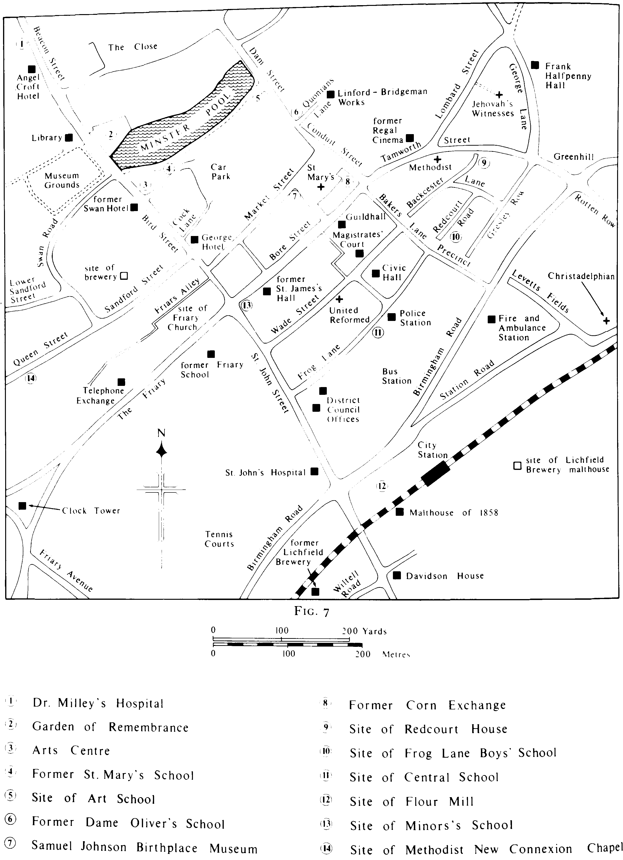
LICHFIELD: central area 1989
The building of housing estates continued on the north and east sides of the city in the 1970s and 1980s, (fn. 27) and Eastern Avenue, running from Stafford Road to Trent Valley Road, was built in 1972. (fn. 28) The main growth, however, was on the south-east side. There had been some building there following the end of the Second World War. A private estate in Cricket Lane between London Road and Tamworth Road was begun in 1946, (fn. 29) and the first phase of the council's Cherry Orchard estate was finished in 1951. (fn. 30) In the earlier 1960s a private estate was built in the Minors Hill area west of Quarryhills Lane. (fn. 31) The Eastern Bypass running close to the south-east boundary from the A5 to Streethay was opened in 1971. (fn. 32) The main housing development was the Boley Park estate north-east of Broad Lane, begun by the late 1970s. (fn. 33) By 1986 it contained c. 1,700 houses with another 500 planned for 1987 and was claimed as one of the largest private estates in the country and among the top 10 in Europe. (fn. 34) A supermarket was opened there in 1984 as part of a shopping centre which was completed in 1985. (fn. 35) The Cappers Lane link road was opened north of the estate in 1984 to join Eastern Avenue and the Eastern Bypass. (fn. 36)
Several industrial estates were laid out on the east side of the city from 1946 to the 1980s. Their growth was encouraged by the building of Eastern Avenue and its extension along the Cappers Lane link road. (fn. 37) Two further commercial developments took place in the late 1980s. In 1988 the foundry of Chamberlin & Hill in Beacon Street was demolished and a Safeway supermarket was built on the site. In 1989, after Wintertons had moved their smithfield from Greenhill, the site was cleared and a W. H. Smith DIY store and a Tesco supermarket were built there.
Tourism was promoted in the 1980s. In 1986 the tourist information centre in Breadmarket Street was moved to premises in Donegal House in Bore Street, claimed as the largest and most comprehensive centre in Staffordshire. (fn. 38) The dean and chapter were active in the work. In 1980 they organized a music festival centred on the cathedral which became an annual event in 1982, with its scope later enlarged to include drama and opera. (fn. 39) The first part of the Lichfield Cathedral Visitors' Centre in the former diocesan registry in the Close was opened in 1986, and the centre was completed in 1989. A cathedral bookshop and coffee shop were opened in the Close in 1988. (fn. 40)
Lichfield rural district, formed in 1895, centred on Lichfield. At first the council met in the workhouse, its clerk's office was in Breadmarket Street, and its surveyor's office was successively in a private house, in a room in the workhouse, and from 1917 in two rooms in Mill House, Station Road. In 1917 the council bought the former grammar school and master's house in St. John Street from Dr. H. M. Morgan, the owner from 1903, and from 1920 the school was used as the council chamber and the house as offices. The premises were also used by the guardians of Lichfield poor law union until their dissolution in 1930, and the register office of Lichfield registration district was in the house until 1939. (fn. 41) With the reorganization of local government in 1974 the buildings passed to the new Lichfield district, which in 1987 also opened offices in Frog Lane designed by Butler Wones Partnership. (fn. 42)
In 1974 the city was absorbed into Lichfield district, but in 1980 it re-emerged as a parish council which was granted city status later the same year with the chairman of the council styled a mayor. The sheriff's office survived the changes of 1974, and the sheriff continues to perambulate the city bounds every September. Several other ancient institutions and customs survive. One of the medieval manorial courts, that held on St. George's day (23 April), still meets. A court of pie powder continues to be proclaimed on Shrove Tuesday with the only surviving fair, and after the ceremony the mayor and civic party retire to the guildhall for refreshments which traditionally include simnel cake. The Greenhill Bower, with festivities dating back to the Middle Ages, is held on Spring Bank Holiday Monday. Of the numerous city companies, only the smiths' survives, and it admits among its freemen people who have given outstanding service to Lichfield. The Conduit Lands Trust, although it ceased in 1963 to be concerned with the provision of water, remains extensively involved in its second object, the promotion of the common good of the city. A similar object is pursued by the Swinfen Broun Charitable Trust. It was established in 1974, at the time of the reorganization of local government, under the will of Lt.-Col. M. A. Swinfen Broun (d. 1948) of Swinfen Hall in Weeford, who left half his residuary estate to the mayor and corporation of Lichfield. (fn. 43)