The Records of St. Bartholomew's Priory and St. Bartholomew the Great, West Smithfield: Volume 2. Originally published by Oxford University Press, Oxford, 1921.
This free content was digitised by double rekeying. All rights reserved.
E A Webb, 'The parish: Itinerary of cloth fair', in The Records of St. Bartholomew's Priory and St. Bartholomew the Great, West Smithfield: Volume 2(Oxford, 1921), British History Online https://www.british-history.ac.uk/st-barts-records/vol2/pp232-247 [accessed 30 April 2025].
E A Webb, 'The parish: Itinerary of cloth fair', in The Records of St. Bartholomew's Priory and St. Bartholomew the Great, West Smithfield: Volume 2(Oxford, 1921), British History Online, accessed April 30, 2025, https://www.british-history.ac.uk/st-barts-records/vol2/pp232-247.
E A Webb. "The parish: Itinerary of cloth fair". The Records of St. Bartholomew's Priory and St. Bartholomew the Great, West Smithfield: Volume 2. (Oxford, 1921), British History Online. Web. 30 April 2025. https://www.british-history.ac.uk/st-barts-records/vol2/pp232-247.
In this section
CHAPTER XIV - THE ITINERARY OF THE CLOTH FAIR PRECINCT, THE ALMSHOUSES, AND THE LONG LANE PRECINCT
Itinerary of Cloth Fair
The fair ground as it probably appeared in monastic times has been already described. (fn. 1) It was then variously known as 'the Great Green of the Market', (fn. 2) 'the Market of St. Bartholomew', and 'the vacant land of the Fair of St. Bartholomew'. (fn. 3) Since the suppression it has been generally known as Cloth Fair. Its monastic bounds apparently remained unchanged, as a convenience to the Rich family who retained the property within the Cloth Fair precinct in their own hands, whilst that in the Close precinct was disposed of either as glebe to the rectory, or by sale to divers people, save the monastic buildings called in the rental the 'Capital Mansion House' which were retained and separately leased by Lord Rich, as has been seen.
It would seem from Agas's map, which dates from about the year 1563, that the first Lord Rich, who died in 1567, allowed the fair ground to remain in its monastic condition during his lifetime. It is also probable that his son Robert, the second Lord Rich, who died in 1581, did no serious building here, because Hoefnagel's map of about 1572 shows the ground still open, and there are no records of building operations having taken place there in his time. But when Robert, third Baron Rich (the husband of Penelope), created later Earl of Warwick, came into possession in 1581, he took steps to develop the property. After having obtained from the queen, in the year 1583, confirmation of his rights and privileges, (fn. 4) he started to cover the vacant ground by granting apparently thirty-one year building leases. This was in or about the year 1590, for in that year Lord Rich wrote to a Mr. Hicks to ask Lord Burleigh to persuade the Lord Mayor of London not to stop his building at St. Bartholomew's. (fn. 5) This appeal unfortunately seems to have been effectual as the erection of the crowded buildings went on; in fact it appears that Rich exceeded his rights, for about the year 1595 the Court of Aldermen directed that 'Lord Rich be waited upon touching a building set up by him on the city's soil near Gt. St. Bartholomew's'; (fn. 6) and later they directed that 'an encroachment in Long Lane near St. Bartholomew's by the tenant of Lord Rich be viewed'. (fn. 7)
It is probable that the buildings in Long Lane, and from the church to the Smithfield gate of the Fair (that is to say the buildings on the north side of the great churchyard), and the buildings, demolished in 1917, in Cloth Fair eastward of the north door of the church, were completed by the year 1597, for the leases in the rental of 1616 date from that year. (fn. 8) The north and south sides of Cloth Fair, Kinghorn Street, and the north side of Middle Street had leases dating from 1598. The leases on the south side of Middle Street, on both sides of Newbury Street, and from Sun Court to New Court, dated from 1608 to 1614. The houses were probably all finished, or nearly so, when Lord Rich conveyed the property to his son Henry on the latter's marriage with Isabel Cope, in the year 1612. Building, however, was still going on somewhere in the parish between 1651 and 1653; (fn. 9) even as late as 1669 there is a record that the Court of Aldermen ordered 'a stay to be made of buildings in the parish of St. Bartholomew', (fn. 10) but this was probably in the Close precinct.
It is interesting to note that the outcry raised in the sixteenth and early in the seventeenth centuries on the erection of these houses, was raised again early in the twentieth century on their demolition. At the latter time Cloth Fair was one of the last bits of Elizabethan London left, and as such it was a favourite subject for the antiquary and artist. When therefore in 1914 the Corporation decided to remove the picturesque old houses backing on to the graveyard, under their improvement scheme of that year, and when they pulled down the houses on both sides of the Fair in 1917 under a sanitary scheme, known as the City of London (Housing of Working Classes) Order 1913, there was considerable protest. But on both occasions there was compensation, for in the first the only remaining bay of the nave of the church, with its interesting thirteenth-century window and remains of its twelfth and thirteenth-century aisle vaulting, was uncovered, and in the second the apse of the church and the Lady Chapel were opened to view. In addition, insanitary buildings were removed and also light and air were admitted into this part of the parish and a playground was provided for the children.
But for a change in the names of the streets, about the year 1638, there had been but little alteration in the Cloth Fair precinet since the survey was made for Sir Henry Rich in 1616. The twentiethcentury changes really commenced about 1892, when the houses on the south side of Cloth Fair, Nos. 12–16, were rebuilt; in the same year, Nos. 9½, 10, and subsequently No. 11, had to make way for the restored north transept of the church and the beautiful porch which stand in their place. In 1916 the picturesque Dick Whittington public-house, No. 24 Cloth Fair, was acquired and subsequently was demolished by the Corporation as part of their sanitary scheme (pl. LXXXVII); and in 1914 part of the west end of the Fair, and in 1917 more of the east end of the Fair, as mentioned above, were removed. The grotesque figures from the Dick Whittington, and the coat of arms from Warwick House (No. 22 Cloth Fair), are preserved in the Guildhall Museum.
There still remains (pl. LXXXVIII a, p. 235) in the western half of Cloth Fair, on the north side, an interesting example of a Jacobean house (numbered 41 and 42) which has a wooden projecting window and a weather-boarded fourth story. No. 40 is still occupied by a wholesale firm in the cloth trade—Mitchell, Inman & Co.
Cloth Fair was described by Strype in the year 1720 as 'a place generally inhabited by drapers and mercers and is of some note': (fn. 11) it was never a place of residence like the Close, because of the unreasonable and inconsiderate way in which it was crowded with small houses, as already shown.
On the Hearth Tax Roll, of about 1666, the Cloth Fair precinct is separately assessed. The only building with 13 hearths is the Almshouses, but as these were but three one-roomed cottages it is probable that the assessor thought all the twelve tenements in Back Court were almshouses. Besides this instance of 13 hearths there were two houses with 8 hearths, two with 7, and two with 6; there were 12 with 5 hearths and 159 with less.
An itinerary of the Cloth Fair precinct may advantageously be made by following the survey of 1616, already alluded to, and comparing it with the present conditions; and to facilitate the comparison a plan of the whole parish as described in 1616 has been made (p. 77). The exact title of the survey of that year in the Record Office is: 'A survaie of the libertie of Great St. Bartholomewes and Cloth faire there, being part of the Inheritance of Sr. Henry Rich, Knight. Made and taken in November 1616 by Gilbert Thacker'. (fn. 12) The survey commences at the east end of the parish and works westward.
Newbury Street in the south-east of the precinct has, in the P.O. Directory, thirty-one numbers, but there are only eighteen occupants, as of recent years the dwelling-houses have for the most part been rebuilt as small factories, such as fancy-box makers, scarf manufacturers, spring-blind makers, &c. In 1616 the survey shows that there were thirty-three houses let to eleven lessees, whose leases were for thirty-one years and were all dated 1614; the rent paid was in all £23 16s. 8d., but the surveyor says they were then—two years later—worth £187 10s. The south side of the street was at that time called 'Rugman's Row' and consisted of eighteen houses, whilst the north side was called 'Kentish Row' with fifteen houses. The houses are described in the Rental as 'uniformly built with bricke and have amongest them there the benefit of a pump standing in the streete about the middle of the rowe and have prospect backwards into the gardens of Sir Henry North (fn. 13) and Mr. Doctor Martin'. The average width of the houses on that side was only 11 ft. 4 in.; of those on the opposite side 14 ft. 4 in. The second house in Rugman's Row was occupied by 'Anthony Low, Esq., Counsellor at Law', who paid £11 a year rent. He died in 1641, when a mural tablet was placed in the church to his memory. (fn. 14)
In an account of the profits arising from the fair in 1629 (fn. 15) reference is made to 'where the Rugg men have 15 shops', so we may assume that the name of the Row was derived from the fact that rugs were sold there during fair time. In 1639 the street was re-named New Street, which was changed, at the end of the nineteenth century, to Newbury Street.
Middle Street, 'Cloth Fair' (as it is always called in the records), is now in line with Cloth Fair on the north of Newbury Street. There are twenty-four numbers in the P.O. Directory but only fifteen occupiers, for the same reason as in Newbury Street. There are now in the street a mantle manufacturer, a blouse manufacturer, a gold blocker, a surgical bootmaker, a cats' meat dealer, and so on. In 1616 there were thirty houses held by nine persons who paid in all £39 14s. annual rent; worth, says Gilbertone Thacker, £274 a year. The leases of the houses on the north side were all dated the 40th Queen Elizabeth (1598); those on the south dated from 1608 to 1614, from which it would seem that the north side of Middle Street was built before the south side and before either side of Newbury Street.
The south side of Middle Street is called in the survey 'Court House Row', doubtless from the fact that the Court of Pie-powder was held at this time at the 'Hand and Shears' public-house there; (fn. 16) a house which still stands (though rebuilt) at the west corner of the south side of the street. The north side of the street is variously called 'Kelshawe's Rowe' in the survey of 1616, 'Kelsick Rowe' in 1629, and 'Kelsey Row' in the Exchequer Plea Rolls of 1719; it was probably called after a man named Kelshaw.
East Passage is for pedestrians only and runs between the backs of the Middle Street and Long Lane houses.
Back Passage is a continuation of East Passage westward at theback of Cloth Fair into New Court, and is figured on Ogilby's map of 1677.
Cloth Street runs southward from Long Lane at the back of the Manchester Hotel and gives access to East Passage, Middle Street, and Newbury Street. In the survey it is not described as a street or row but the land at its southern end is described as 'the East end of Cloth Fair', and in Ogilby's map a considerable part of the land is shown to be open as a garden or yard. There were five houses here. (fn. 17) One at the south end was described as 'one faire stable of bricke and a hay lofte and lodging for a groom over the same situate at the south-east corner of Cloth Faire with an entrance, the breadth of an ordinary house, at the end of Rugman's Rowe'. This entrance being apparently in Rugman's Row would have led in the eighteenth and early nineteenth century to the Aldersgate workhouse, leased by the parish of St. Botolph and built on the site of Dr. Martin's garden. It now leads into Collingridge's printing works.
Leading out of Cloth Street into Aldersgate Street, on the site of the house just described, by the south side of the Manchester Hotel, is a passage now without a name. It is protected by a gate and was known in the eighteenth century as Cox's passage. (fn. 18)
Three of the five houses mentioned as being in Cloth Street were at the back of Edward Walmsley's house, which was the Green Dragon Inn in Long Lane; they were held by Richard Toppin on lease with his houses in Longtyled-house Row, which is referred to below. The fifth house is described as consisting of '8 bayes enclosing two sydes of a large yard built open below and above with faire chambers and garrets over them, the whole length of the 8 bayes'. It was apparently to the immediate east of Dr. Martin's stables. In 1629 this street was called 'Green Yard Gate' (fn. 19) in reference probably to the inn. In the parish map of 1828 'Wiggan's stable buildings' are shown here, which must have belonged to the Green Dragon; they are now covered by the Manchester Hotel.
Cloth Fair: the Eastern end of the North side (pl. LXXXIXa, p. 238). Before its demolition in 1917 this part consisted of fifteen houses, Nos. 24 to 38, or if the Rising Sun Tavern, which now occupies No. 38, were two houses converted into one, the number of houses would then be sixteen, the same as given in the survey of 1616, where it is stated that 'The Starre Tavern' consisted of two houses so converted. The latter was probably a predecessor of the 'Rising Sun', which still remains standing, being outside the Corporation's scheme. In 1616 these houses were known as Longtyled-house Rowe. They were held on lease by five tenants at a total annual rent of £18 0s. 8d., but valued as then worth £152 a year. Three of the leases dated from 1598, one from 1603, and one from 1604. One of the leases was held by David Dee, presumably the rector of that name; Richard Toppin had a lease of five houses in which, says the survey, the three houses in Cloth Street referred to above were included; and it adds '1 other being the Ould Court House in his own occupation', (fn. 20) meaning that the old court-house was not here but in the same lease. In our opinion the Old Court House was in Long Lane. It is not included in the 'particular' of Long Lane, apparently because it was included in the lease of these Longtyled-house Row houses. But the survey, it will be seen below, describes some houses under the description of 'From Smithfield Gate to the ould Court house', which can from internal evidence be none other than Barley Mow Passage, beginning at the south and ending in Barley Mow gateway; on the east side of the gateway is the Barley Mow tavern and this was probably the old Court-house. Toppin had one lease of two houses and another of one house in Long Lane, but they were all farther east than the Barley Mow and none in his own occupation.
One house in Longtyled-house Row had the sign of the 'Red Lyon', which on the plan we have placed opposite the end of Red Lion Passage, though in 1783 the vestry minutes refer to the Red Lion as being in King Street. (fn. 21) The proprietor at that time was severely reprimanded by the vestry for allowing card-playing in his house, and in 1803 his licence was cancelled (though renewed later) for allowing 'tippling' during Divine Service. The Dick Whittington at No. 24, referred to above, claimed to be the oldest licensed house in the City, but it is not once mentioned in the Vestry Minute Books; moreover, the house in the year 1800 is figured in the European Magazine as a butcher's shop, and in a drawing by T. H. Shepherd as a hairdresser's. (fn. 22)
Kinghorn Street, which up to the end of the nineteenth century was known as King Street, runs south from Red Cow Gate to the position of the gate already described as leading into the monastic close, for which reason no doubt it was known at the time of the survey as 'the Close gate rowe'. (fn. 23) In 1917 there were five houses on the west side, Nos. 6 to 10, and one on the east side which backed on to the north side of Middle Street. In 1616 there were ten houses, four let on a thirty-one years' lease from 1598 to one person, and six to another person at a total rent of £18 5s., valued at £76 a year. The first house mentioned was occupied by Francis Anthony, the well-known empiric, whose memorial is in the church. (fn. 24)
Red Lion Passage lies at the back of Kinghorn Street westward. The only house besides the schools standing on the west side was pulled down in 1917, being included in the Corporation's sanitary scheme, and the site was conveyed to the rector and churchwardens for an open space or playground. On the east side is a model dwelling known as Bartholomew House, erected in 1890. According to Ogilby's map of 1677 there was no thoroughfare through the passage to the Close precinct as there is now. In the survey it is called 'Harts horne rowe' and consisted of three houses held on lease by Thomas Rogers for thirty-one years from Lady Day 1598, for which he paid a rent of £4 15s., valued by the surveyor at £32 a year. One of the houses was the sign of the Hart's horne, which contained, as already shown, 'a low chamber called the stone room under part of Sir Percival Hart's house'. (fn. 25) Whether the name of Hartshorne has any connexion with Sir Percival Hart, or whether the name of Horne's yard in Rocque's map for Back Court (which was at the back of Hartshorn Row) refers to a man or to a corruption of the word Hartshorne, we cannot say: it is probably a mere coincidence that King Street should have been changed at the suggestion of the Metropolitan Board of Works in 1885 to Kinghorn Street.
Cloth Fair: the Eastern end of the South side. There were twelve houses here before the demolition in 1917, numbered 12 to 23. No. 23 was rebuilt so recently as 1894 and Nos. 12 to 16 in 1892, so these were left to be pulled down after the War. No. 22 (pl. LXXXVIIIb, p 235) was known as Warwick House, because it had on its north front the arms of the Rich family (gu. a chevron between three crosses botony or) in a plaster cartouche. (fn. 26) It was an old gabled half-timbered house of the end of the sixteenth century. In 1616 there were eleven houses here called 'Newman's Rowe', from one Humphrey Newman who had been an original leaseholder of Nos. 12 to 16 at the west end of the row. It is probable that at that time No. 23 at the corner of Kinghorn Street was reckoned as in that street, which would then make the number of houses tally with the number before the demolition. There were five leaseholders; the leases were, like those in the other streets, for thirty-one years. One was dated 1582, which as it is the first mentioned was probably Warwick House; three from 1598 and one from 1612; the rents paid amounted to £17 6s. 8d. and the yearly value was £88.
Back Court, before the demolition of the Cloth Fair houses, was a small yard at the back of Nos. 18 to 21. It was entered by a narrow covered way between Nos. 21 and 22 and continued as a narrow alley to the transept of the church. The difficulty of keeping this back alley clean and respectable was the origin of the sanitary scheme of the Corporation. The backs of the Newman's Row houses westwards, Nos. 12 to 17, projected over this passage until the close of the nineteenth century, when, in 1891, Nos. 12 to 16 were rebuilt. The backs of all the Newman's Row houses opened on to Back Court, on the south side of which, at its eastern end, still stood one of Thomas Rogers' two cottages, until it fell in 1904 (pl. XC), and two almshouses pulled down in 1896, all of which backed on to the Lady Chapel. (fn. 27) At its western end the south side of the alley was, in the first half of the nineteenth century, a burial-ground for the poor (pl. LIX, p. 119).
In the survey of 1616 Back Court is called 'The Ould Gallery' and consisted of twelve small tenements. The two houses at the eastern end just mentioned were held by Thomas Rogers with his three houses in Hartshorn Row. They were valued at £10 a year. The other ten, though they were all occupied, must have been small one-roomed cottages valued at £2 to £4 a year. In 1632 Lady Saye and Sele bought some of them to build her three almshouses, (fn. 28) which were, in 1632, placed against the Lady Chapel and the east end of the north aisle of the church. In the survey there is a note in another hand 'all thes that is cros is into the skole hous and ames houses built by my lady see'. Rogers' two houses were not marked with a cross; three or probably four, that were so marked, had been converted into three almshouses, and six would have stood against the church, below the school windows, and between the school-house turret stair, still standing, and the transept.
Our Lady's Green. There was a portion of the Fair precinct known as our Lady's Green, a name probably handed down from monastic times, but there was no street so named. It was that portion of the monastic fair ground that extended from the east end of the Lady Chapel to the north transept. This is shown, as to the east end, from an entry in 'Mr. Barks' book, referred to above, in which he describes 'Hartshorn Thomas Rogers house' which was in Red Lion Passage as being in 'Ladyes Greene'. As to the space between the east end and the transept, when T. Rayner assigned his interest to Edward Holmes in a lease granted to R. Holmes in 1598, he refers to the three houses built on the site of the transept (referred to below) as being in Cloth Fair lately known as 'Our Ladys Green'. (fn. 29) And when in 1629 Alderman Sir Hugh Hamersley was in possession of the same lease and assigned it to the rector and churchwardens for the poor he described the property as in 'Ladyes Green—lying upon the church on the south within the Cloth Fair', thus leaving no doubt as to the site of 'Our Ladys Green'.
Holmes before 1629 had built three houses on the transept site known as 'Holmes his buildings', leaving some eight booths on the property which possibly were those in Back Court.
Cloth Fair: the Western end of the North side (pl. LXXXIX b, p. 238). This includes Sun Court, New Court, and the east side of Barley Mow Passage, which all run at right angles to Cloth Fair. The houses in this section were not included in either of the Corporation's schemes, so are still standing. Sun Court takes its name from the 'Rising Sun' public-house on its east side (No. 38), which, as suggested above, was the successor of the Star Tavern. (fn. 30) New Court runs parallel with Sun Court, between Nos. 42 and 43, and turning east joins it and encloses a block of buildings consisting of the cloth and woollen warehouse (Nos. 39 and 40) and the old Jacobean house (Nos. 41 and 42), both referred to above. (fn. 31) Barley Mow Passage runs parallel, again farther west, through a covered way (where was a parish gate) (fn. 32) into Long Lane. The houses between it and New Court (Nos. 43 to 45) now present no features of interest.
The block between Sun Court and New Court is described, in the survey of 1616, as 'The 11 houses upon the square in Launders Green'. Reference has already been made to this and the next block up to Barley Mow Passage as being the laundry ground of the monastery. (fn. 33) The eleven houses were held under five leases, each for thirty-one years from 1614, which was therefore probably the date of the Jacobean house referred to above. The total annual rent paid was £7 6s. 8d. and the value assessed by the surveyor was £85. There is a note in the survey that 'In the middest of this square is contayned a courte comon to all these tennants with a pumpe of very pure water in the middle thereof, into which courte there is an entry for all the tennants to come into their houses in the faire tyme whilst all the shopps be ymployed'. This well was probably formed to supply water for the laundry.
The next block is headed in the survey as 'Thomas Rogers Builders (fn. 34) in Launders Green', probably the same Thomas Rogers who is mentioned in connexion with Hartshorn Row; (fn. 35) but as the survey describes this block later on we will keep to the same order.
Cloth Fair: the Western end of the South side. This now (1921) consists only of the north porch of the church; of ground vacant by the demolition, in 1914, of the houses Nos. 6 to 9 Cloth Fair; of the house No. 5 (demolished after the war under the Corporation improvement scheme), and of No. 4 not included in the scheme.
The survey of 1616 describes the houses then standing on the site of the north transept of the church under the title 'Holmes his buildings'. These consisted of the three houses referred to above; the original lease was for thirty-one years from 40 Elizabeth (1598) at a yearly rent of 20s., valued at £24 a year. The first of the three, described as 'situate close to the church wall', was in the tenure of Richard Holmes; the third was known by 'the sign of Three Tonnes'.
We learn from a deed in the parish safe, quoted above, (fn. 36) that these three houses were built in 1598 by Edward Holmes (the elder), to whom Godfrey Rayner sold his interest in the lease in 1602. The lease subsequently came into the possession of Alderman Sir Hugh Hamersley (as stated above), (fn. 37) who sold it to the rector and churchwardens for £10, the income to be applied to the benefit of the poor. Before this, however, the churchwardens somehow had the benefit of the lease because there are among the churchwardens' papers of the years 1616, 1617, and 1618, receipts from the steward of Lord Rich for 20s. for one whole year's rent 'for certain tenements called the three tuns sometime Holmes' '. In the survey only one of the houses is called 'the three tuns'. Again in 1629 the churchwardens' accounts show that they 'received £8 at the three tuns' from one John Sankey for his whole year's rent. There is also a lease (fn. 38) by the churchwardens for twenty-one years of the Three Tuns in Cloth Fair at a rent of £14, a previous lease of 1669 to be cancelled and £30 paid. There is also a lease dated 1690 (fn. 39) granted by the churchwarden to one George Webb of 'that shop or shed on the east side of the passage leading to the parish church, together with a room lying over the gateway' for 20s. down and 30s. paid yearly for the use of the poor. And in 1704 the same shop was let for six years at a rental of £3 a year. (fn. 40) The shop was one of 'Holmes' buildings', but we have no record of the room lying over the gateway.
The section westward of the north porch was called in the survey 'from the church to the Smithfield gate'. There were ten houses, the total rents due to Lord Rich amounting to £2 13s. 4d. but valued at £102. The dates of the leases varied from 1597 to 1606. The first seven houses are described as having 'prospects backward into the churchyard' (pls. XC, p. 239, XCI, XCII a). These would have been the picturesque Elizabethan houses demolished in 1914 (referred to above). The first is described as 'situate at the new north doore of the church'. (fn. 41) The leases of the other three houses were held by Robert Chamberlayne, whose monument is in the church, and who died at sea the year before the survey was made. The first house was known by the 'signe of the Horslytter'; the third by the 'signe of the Coach with two stables of deale board, and was a coachman's shop'. It is described as 'joyning to the church in Smithfield containing at the entrance thereof out of Smithfield two stables for about 8 horses, one small yard and dwelling-house within the same opening on the churchway south and abutting on the churchyard east'. 'The Coach' therefore faced Smithfield (as shown on the plan) and with the second of Chamberlayne's houses (of which no description is given) was all there was, besides the gateway, to represent the façade of the great monastic church. The small yard referred to was brick paved, and in 1906 was built over when the lofty building at the west end of the graveyard was erected. Chamberlayne only paid 13s. 4d. ground rent, but the houses were valued at £50.
The surveyor then returns to Thos. Rogers' buildings as above. They consisted of four houses all leased to Rogers (at a sum not mentioned) for thirty-one years from 1609. One occupied by a blacksmith had a forge, one was empty, one was built from the ground floor to the first floor of brick, the remainder of timber. The fourth was a large house with a three-stall stable, a gate of entrance, a large room of three bays with a room and garrets over of the same size, and a cellar below. It joined at the north end the house of Thomas Back, which was in Long Lane and was also in Rogers' occupation. Rogers, says the surveyor, also had a house of his own used with this. It contained a cellar, a kitchen, a hall over, two chambers and a garret, with a pump at the kitchen corner. At the back of the three-bays building there was 'a pretty court or yard enclosed on the east side with 5 bayes of stabling' and 'a house of office'. This must have been an important place seeing that it was valued at £46 a year, and Sir Percival Hart's house in the Lady Chapel was only valued at £40.
Mr. Bark (fn. 42) in his account of the profits of Bartholomew Fair, giving the number of shops as booths at fair time, says 'Launder's Green, Mr. Thos. Rogers his buildings viii bayes and one shop' and 'Launder's Green ye second rowe vii bayes and one shop'. The 'bayes' were probably the stalls of a stable used as booths.
Barley Mow Passage east side is called in the survey 'From Smithfield Gate to the ould Court-house'. At present there is but one house numbered 51; it is at the back of the Barley Mow, which is No. 50 Long Lane, but in 1616 there were nine small tenements, or rather eight and two booths. The first is described as joining 'The Bores Head nr. Smithfeild Gate', which, with seven other tenements, were all held by one lessee at an annual rental of 32s. 6d. and valued at £43. The two booths at the northern end are described as 'the last of that rowe towards Mr. Rogers'. The rent of these two booths was only 10s., valued at 30s. The old court-house to which this passage led, which we have suggested was the Barley Mow Tavern, is not mentioned in the survey here or in Long Lane for reasons already given. (fn. 43)
Of West Smithfield the eastern part only is in the parish, commencing with Nos. 55 to 57 which are south of the Smithfield Gate. The Gate House (over the gate) is also reckoned as part of No. 57, for, though in separate ownership to the house on the south of the arch, there is a common stair to the two houses. Nos. 55 to 57 are all halftimbered houses covered with tiles made to resemble bricks, such as were removed from the Gate House in 1916. (fn. 44) Nos. 58 and 59 are the lofty building erected by Biggerstaff the bankers in 1907. They, together with the Smithfield Gate, occupy the position of the west façade of the church which the survey includes as mentioned above with the houses 'from the church to the Smithfield Gate'. The houses north of the entrance to Cloth Fair, Nos. 60 to 66, called in Henry VIII's grant to Rich Le Ramyge (fn. 45) are not included in the survey of 1616, probably because they had been sold previously. Nos. 62 and 63 are in St. Sepulchre's parish, as we have seen. (fn. 46) No. 60, which in 1616 was the 'Boar's Head', is now (1921) the London Joint City and Midland Bank; No. 66 is Lloyds Bank.
It is explained in the history of the Fair how the shops in the Cloth Fair precinct were reserved for Lord Rich during fair time to let as booths for the fair. (fn. 47) The leases also contained a covenant whereby the tenant undertook that there should 'not be entertained or harboured any inmates or more families than one in the same messuage at once without the consent of the parson and churchwardens of the parish of Great St. Bartholomew's obtained in writing', and that 'no tenant or lodger shall there use the trade of making tobacco pipes'.
The Almshouses.
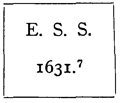
As these were in the Cloth Fair precinct they may be conveniently referred to here (pl. LXII, p. 120, and pl. LXXXVI a, p. 215). They were founded by Elizabeth, Lady Saye and Sele, a daughter of Elizabeth Scudamore, to whom there is a tablet in the church. (fn. 48) In her will, dated the 5th February 1631/2, she bequeathed to the parish 'the three houses and tenements she had built in the Cloth Fair upon ground she had bought that year of the Lord of Holland to place three widows in, and for their maintenance a house and tenement that she had bought that year, the corner house as you go by the church, of one Perry'. (fn. 49)
The almshouses had to be rebuilt in 1693 by the parishioners at a cost of £30. (fn. 50) In 1763 one of the houses fell (fn. 51) and was not rebuilt, and the other two were repaired by order of the vestry, which, in July of that year, empowered 'the churchwardens to repair the two almshouses which were still standing in Cloth Fair; to get the rubbish removed of a third which had lately fallen; to repair the house belonging to the almshouses and to enclose the ground where the demolished house stood'. This latter house had stood against the church in the angle formed by the junction of the Lady Chapel with the north ambulatory of the church; the other two, adjoining on the east, backed against the Lady Chapel.
These two remaining houses were again rebuilt in 1823 at a cost of £92, (fn. 52) and the fact was inscribed on a tablet fixed outside the building as follows: (fn. 53)
Inscription on tablet
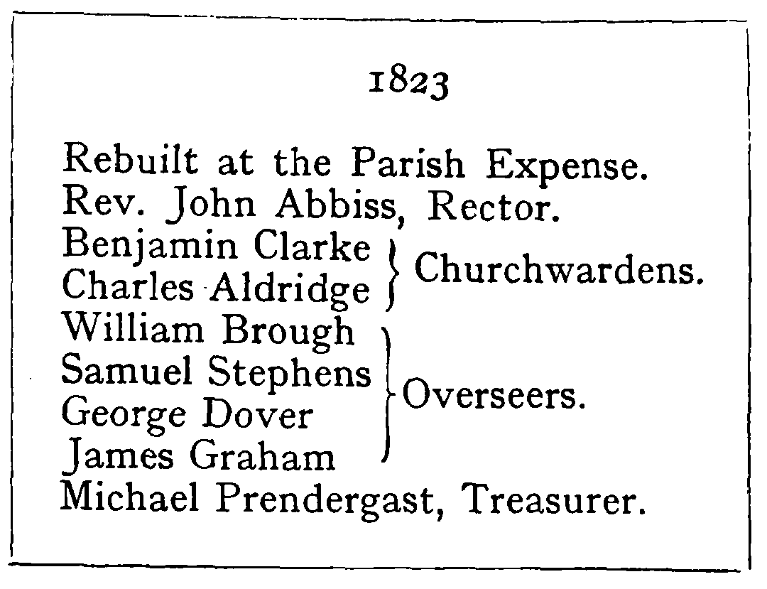
Inscription on tablet
The tablet is now preserved in the south triforium of the church.
In 1852 the vestry resolved to apply a certain £21 'for the purpose of erecting an almshouse on the spot adjoining the others where one formerly stood'. (fn. 54) But in the following April the resolution was rescinded for one reason that in the meantime, the site having been used as a burial-ground, 'there was no ground on which it could be built'. The evidence of one Samuel Stephens, who was overseer when the houses were rebuilt in 1823, was invoked to show that there had never been more than the two houses. He made an affidavit (fn. 55) that the two houses had the same frontage aforetime as then, and that when he was churchwarden from 1819 to 1821 he had given directions for the burial of the poor in the vacant site 'and that no almshouse or building existed on the said burial-grounds nor was any new ground enclosed for the churchyard'. Stephens, of course, was wrong about the original number of almshouses, but right as regards the burials; for, although these burials against the church wall were removed in 1864 to form a dry area round the church, still two bodies were found there in 1911 during the search for the foundations of a chapel.
Under the City of London Parochial Charities Act of 1883 the parish was deprived of its almshouses, and they were, in 1894, bought back from the commissioners for £150, and pulled down in 1897 for the restoration of the Lady Chapel of the church (as is shown later). (fn. 56)
Long Lane Precinct.
That Long Lane formed a separate precinct is proved by the Hearth Tax Roll giving a separate list for 'Long Lane Precinct', and by the fact that it had its own constable and watch-house; in January 1705/6 Anne Doncastell is registered as being 'buried from the middle of Long Lane near the watch-house'.
Long Lane has already been referred to in the chapter on the bounds. John Stow, writing in the year 1598, said 'The north wall towards Long Lane being taken down a number of tenements are there erected for such as will give great rents', which date is confirmed by the fact that the leases in the survey of 1616 are dated 1597 and 1598. In 1720 Strype wrote: (fn. 57) 'The Lane or rather street is good; the houses pretty good for timber buildings, and is very well inhabited by shopkeepers who deal in apparel, linen and upholsterers goods, both new and old'. Now the western half of the street is largely occupied by butchers' cutlers and butchers' clothiers; the rest with traders of all kinds. No. 56 is still (1921) a timber house. It stands on the west side of Sun Court and has a wooden painted gable front and a wooden side. No. 73, on the eastern side of the Cloth Fair gateway, has a projecting window in front and a half-timbered back covered with tiles like bricks, as was the Smithfield gate-house. Here the licensed houses are numerous, but the numbers of those attending the meat market to be catered for are very large. There is at No. 50, the Barley Mow. The White Hart is at No. 69. Next door but one, Nos. 71 and 72, is the old Red Cow, which stretches across the Cloth Fair or Red Cow gateway. The Dick Whittington was next door in Cloth Fair, and the Hand and Shears in Middle Street (both already referred to) is only a few yards away. The presence of so many licensed houses within the parish has certainly been detrimental to the residents of the lower classes, both men and women. In the parish map of 1828 there was another house at No. 61 by the sign of the Sun and Punch Bowl, and the present White Hart bore the sign of 'The Grapes'. In 1697 there was a house with the sign of the 'Black Swan', for in that year one Mary Howard was 'buried from ye Black Swan in Long Lane'. (fn. 58)
In the survey of 1616 there were forty-six houses in Long Lane. The principal one was the Green Dragon Inn referred to above under Cloth Street. It stood on the site of the monastic garner (fn. 59) and on that of a portion of the Manchester Hotel which is within the parish. We learn from the survey that the Green Dragon contained a hall, a kitchen, a large cellar, twelve lodging chambers, and three others, one stable, 51 ft. long and 18 ft. broad, another for eight horses and another for three, a court-yard 66 ft. square, a draw well, and a little room joining Cloth Fair. This inn is especially marked in Ogilby's map of 1677.
Thomas Back, the bailiff of Lord Rich, held a lease (twenty-three years from 36 Elizabeth—1594) of three of the houses; one he occupied himself and one was occupied by Thomas Rogers, which, says the survey, was joined at the back to Rogers' building in Launders Green. This house would have been on the east side of the Barley Mow Tavern. Rogers' own house was on the west side of it, which the survey describes as 'contained in the rest of his building in Launders Green', but he was not the occupier. The survey also says of it that it was 'the last towards Smithfield', by which we assume that the adjoining house at the corner faced Smithfield and not Long Lane.
From the Hearth Tax Roll (fn. 60) we learn that there were two houses in the Long Lane precinct assessed at 9 hearths; three at 8; three at 7; four at 6, and forty-five at 5 and under.
The surveyor of 1616 thus summarizes the inheritance of Sir Henry Rich in the Close, in Cloth Fair and Long Lane, as given in the survey of 1616:
| 'General Conclusion. | £ | s. | d. |
| Number of tenants | 59 | 0 | 0 |
| Number of tenements | 208 | 0 | 0 |
| Rent paid | 334 | 0 | 2 |
| Yearly value | 2,099 | 10 | 0 |
| Clear improvement | 1,765 | 9 | 10 |
The profits of the faire, tolls, &c., coming to the Lord of the libertie said to be £140.
(Signed) GILBERTONE THACKER. 27th Decr., 1616.'